Showing 563 items
matching panama-canal
-
 Port Melbourne Historical & Preservation Society
Document - CD-ROM, Clipping, E C CROCKFORD, Town Clerk, 1900 - 1910
Digital scan of two books of newspaper clippings (cat no 162 & 251) collected by Town clerk, E C CROCKFORDmelbourne harbor trust - port of melbourne authority, sandridge lagoon, livestock, piers and wharves, amalgamation, local government - town of port melbourne, law, town planning - proposals shelved, celebrations fetes and exhibitions, built environment - domestic, business and traders - hotels, engineering - canals and drainage, fishermans bend, transport, flood, business and traders, health - general health, transport - tramways, sport - lawn bowls, edward c crockford, town clerks -
Port Melbourne Historical & Preservation Society
Book - Submission for AFC Construction Achievement Award, Bayside clean-up project, Roche Bros, 1991
(1)Submission for 1991 AFCC Construction Achievement Award. Bayside clean-up project. (2-3) Two clippings form "The Age" regarding the project.natural environment, engineering - canals and drainage, roger bacon, urban land authority, reeves construction engineers, rms consultants -
Port Melbourne Historical & Preservation Society
Document - Report, Improvement of the Port of Melbourne, Improvement of the Port of Melbourne, 11 Jun 1855
Improvement of the Port of Melbourne -report upon the various plans for the improvement of Port of Melbourne, January 1854 Ten page foolscap on blue paper bound together with thread; .report by Capt C Paisley, Appendix and Particulars of Works by the Colonial Engineer, Lieut. H. Amsinck, RNmelbourne harbor trust - port of melbourne authority, piers and wharves, transport - railways, engineering - canals and drainage, port of melbourne, lieut h amsinck - colonial engineer, captain c paisley -
Port Melbourne Historical & Preservation Society
Plan - Drainage Improvements, Ross Street, Port Melbourne, Borough of Port Melbourne, 3 Nov 1892
Plan of Ross Street drainage improvement diversion drain, 1892.Signatures of J. J. Bartlett (Mayor), A. V. Heath (Borough Surveyor), W. Harrison, Laurence Brady (Contractor)engineering - canals and drainage, james john bartlett, arthur victor heath, town clerks, w harrison, laurence brady -
Port Melbourne Historical & Preservation Society
Plan - Open drainage channel, cnr Beach Street and Railway Place, Port Melbourne, Frederick William Bull, Principal Surveyor, 1862
Plan for open drainage channel at corner of Beach Street and Railway Place, 1892."Open Channel at Foot of Railway Place":Signed by Frederick William Bull, Principal Surveyorengineering - canals and drainage, engineering department - borough of sandridge, frederick william bull, business and traders - hotels -
Port Melbourne Historical & Preservation Society
Plan - Drainage works, cnr Crockford and Raglan Streets, Sandridge, George Kelly, Borough Surveyor, 3 Jun 1864
Sectional plan for drainage work after flood 1864. Corner Crockford Street and Raglan Street.Borough of Sandridgeengineering department - borough of sandridge, engineering - canals and drainage, business and traders - hotels, george kelly -
Port Melbourne Historical & Preservation Society
Plan - Drainage works, cnr Crockford and Raglan Streets, Sandridge, George Kelly, Borough Surveyor, 6 Jun 1864
Ground plan for drainage work after flood 1864. Corner Crockford Street and Raglan Street.Borough of Sandridgeengineering department - borough of sandridge, engineering - canals and drainage, business and traders - hotels, george kelly -
Port Melbourne Historical & Preservation Society
Document - Specifications, Main drain, west branch, Evans Street to Esplanade East, Port Melbourne, Arthur Victor Heath, Town Clerk et al, 14 Mar 1893
Specifications for the construction of main drain west branch 1893 (together with plan attached - refer 75.2)A.V. Heath (Town Surveyor):J.J. Bartlett (Mayor)engineering - canals and drainage, arthur victor heath, town clerks, james john bartlett, mayors -
Port Melbourne Historical & Preservation Society
Plan - Main drain, west branch, Evans Street to Esplanade East, Port Melbourne, 14 Mar 1893
Plan of main drain west branch, from Evans Street to Esplanade East (together with written specifications attached - refer 75.1) 1893.J.J. Bartlett (Mayor) 14/3/93engineering - canals and drainage, arthur victor heath, town clerks, james john bartlett, mayors -
Port Melbourne Historical & Preservation Society
Document - Invitation, Town Clerk, Port Melbourne to attend conference wih South Melbourne Council, 21 May 1892
Request from Town Clerk to attend conference with South Melbourne Council 25 May 1892 to discuss drainage to pumping stationlocal government - borough of port melbourne, built environment - civic, engineering - canals and drainage -
Port Melbourne Historical & Preservation Society
Document - Delivery docket, A E HOCKING for repaired magneto, 8 Jan 1923
Found in pages of item 588 (Town Clerk's Reports); probably related to the running of the pumphouseDelivery docket from A.E. HOCKING of Crockford Street for repaired magneto, signed by George BEAZLEY on behalf of Port Council, 1923Small figures on back in pencilsandridge lagoon, engineering - canals and drainage, george beazley, a e hocking -
Port Melbourne Historical & Preservation Society
Document, Report on the storm water drainage of Port Melbourne, 14 Jun 1904
Amongst items donated to the Society by Bill Thakray.Report on the storm-water drainage of Port Melbourne. Report to Mayor and Councillors of the Town of Port Melbourne, 1904.engineering - canals and drainage, bill thakray -
Port Melbourne Historical & Preservation Society
Functional object - Timber planking section, Outfall Timber Drain Reconstruction, c. 1927
This section of timber was cut from a large quantity of the abandoned timber outfall drain during reconstruction by Melbourne Water. Made available to the PMH&PS by Paul Balassone.Section of timber cut from part of the old abandoned timber outfall drain at Esplanade East during reconstruction 2004engineering - canals and drainage, melbourne water -
Port Melbourne Historical & Preservation Society
Plan - Melbourne and suburbs sewerage works, MMBW, 1 Jul 1908
MMBW map of Melbourne and Suburbs sewerage work to 1-7-1908. Reticulation areas in red, reticulation areas under construction in blue.engineering - canals and drainage, engineering - board of works -
Port Melbourne Historical & Preservation Society
Book - Minutes, Port Melbourne Town Council, Edward C Crockford, Town Clerk, c. 1900
Large volume of rough minutes Port Melbourne Town Council May 1901 - April 1904, with typed and printed minutes inserted throughout - dark green, dark red binding loose and partly missingdeaths and funerals, built environment, port melbourne town hall, societies clubs unions and other organisations, local government - town of port melbourne, social activities, built environment - civic, excelsior hall, engineering - canals and drainage, transport - tramways, edward c crockford, town clerks, port melbourne library -
Port Melbourne Historical & Preservation Society
Plan - Port Melbourne, MMBW, 1987
Very large MMBW plan of Port Melbourne 1987 made up of several sections taped together; drains indicated in blackPMH&PS stamp on backengineering - canals and drainage, mmbw, melbourne and metropolitan board of works -
Port Melbourne Historical & Preservation Society
Photograph - Renewal of storm water drain, Esplanade West, Port Melbourne, Janet Bolitho, Jul 2002
Five coloured photographs of renewal of storm water drain Esplanade West. .01 Esplanade East Street sign .02 Digging .03 Putting in pipe .04 large casing on end of crane .05 Workersbuilt environment - civic, engineering - canals and drainage, natural environment, sandridge lagoon, esplanade east, hmas lonsdale, stormwater drain, melbourne and metropolitan board of works -
 Port Melbourne Historical & Preservation Society
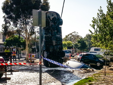
Document - Sink-hole, Liardet Street, Port Melbourne, 17 Dec 2014
In the early hours of Tuesday 16 December, 2014 a water main burst in Liardet St. The resulting sink-hole swallowed two cars and left a massive hole which took 8 days to repair and re-open the road. Several houses on the city side of Liardet St suffered water damage and water also entered the underground car park of the apartment block on the beach side.Photos taken of the damage and vehicle recoveries when a sink-hole opened up on Liardet Street on Tuesday 16 December 2014.built environment - domestic, engineering - roads streets lanes and footpaths, engineering - canals and drainage, liardet street, water supply, fran egan -
Port Melbourne Historical & Preservation Society
Audio - CD-ROM, Talking Book, Fisher Folk of Fisherman's Bend, 2006
Four (4) discs with white labels. Talking book of "Fisher Folk of Fisherman's bend". Distribution copy. Insight into lives of some 19th century fishing families.fishermans bend, families, domestic life, migrants, engineering - canals and drainage, industry - fishing, fisher folk, allan meiers, johann meiers, henry meiers, beazley family, butcher family -
Port Melbourne Historical & Preservation Society
Map, City of Port Melbourne, Oct 1963
Gives a visual understanding of the Port Melbourne area in 1963A detailed map of the Port Melbourne area in October 1963. Details roads and laneways, undeground cables, light and power poles, sewer, bridges, piers reserve and park areas.local government, built environment, piers and wharves, natural environment - beaches and foreshore, parks and gardens, piers and wharves - princes pier, piers and wharves - station pier, engineering - roads streets lanes and footpaths, engineering - canals and drainage -
 Bendigo Historical Society Inc.
Newspaper - LYDIA CHANCELLOR COLLECTION: 'OUR ART: WELL HOUSED IN BENDIGO.'
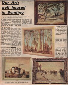
A Bendigo Advertiser supplement titled 'Our Art: well housed in Bendigo.' The Education Officer of the Bendigo Art Gallery, Geoff Paynter, gives an insight into some of the acquisitions purchased by, or donated to, the gallery. There is also an article imbedded within this article on 'Woman of the franchise era.' 14/5/1969.bendigo, buildings, bendigo art gallery, lydia chancellor collection, collection, bendigo, bendigo art gallery, gallery, art, art work, recreation, landscapes, australian landscape, history, r.h.s. abbott prize , john rowell, 'mountain road, ' 'gums, ' sir hans heyton, alfred sisley, 'canal scene, ' dr. and mrs. j. a. neptune scott, impressionism, 'the derelict, ' sali herman, bendigo art prize, emmeline pankhurst, victorian women's franchise league, print, photograph, porcelain, porcelain study design no. 599, w. j. strauchair, 'bondi 1961, ' william dobell, william beebe, arthur boyd, 'pinchin's farm, ' 'the clearing, ' louis buvelot, george bell, 'farm buildings, ' franz kempf, 'burnt orange fern at the wind's return, ' 'old bendigo art gallery, ' kenneth jack, 'the digger and his log, ' sir arthur streeton -
 St Kilda Historical Society
Photograph - Photo map, 17/01/1951
One of a series of photo-maps produced for the Department of Crown Lands and Survey (1857-1983). For correlation with a current map, and access to other historical photo maps of Victoria, see the Historic Photo-Maps Index published by the Department of Environment, Land, Water and Planning at https://services.land.vic.gov.au/DELWPmaps/historical-photomaps/Black and white aerial photograph1414-21 538 Run 19 Lens 12" Melbourne Metropolitan 12150 17.1.51 M586st kilda, st kilda botanical gardens, peanut farm, elwood, 1951, point ormond, elwood canal, st kilda beach -
 St Kilda Historical Society
Photograph - Photo map, 30/01/1960
One of a series of photo-maps produced for the Department of Crown Lands and Survey (1857-1983). For correlation with a current map, and access to other historical photo maps of Victoria, see the Historic Photo-Maps Index published by the Department of Environment, Land, Water and Planning at https://services.land.vic.gov.au/DELWPmaps/historical-photomaps/Black and white aerial photographVic 1091-112 Melbourne & Metropolitan Project Run 23East 30.1.1960 Lens 10" 8.200elwood, point ormond, elwood park, elwood canal, 1960 -
 St Kilda Historical Society
Photograph - Photo map, 14/12/1963
One of a series of photo-maps produced for the Department of Crown Lands and Survey (1857-1983). For correlation with a current map, and access to other historical photo maps of Victoria, see the Historic Photo-Maps Index published by the Department of Environment, Land, Water and Planning at https://services.land.vic.gov.au/DELWPmaps/historical-photomaps/Black and white aerial photographVic 1806 Melbourne 1964 Project Run 18 14.12.63 Lens 205 152.70 M/M 5.150 161elsternwick, elsternwick park, elwood, elwood canal, elwood beach, elwood park, 1963 -
 St Kilda Historical Society
Photograph - Photo map, 08/02/1966
One of a series of photo-maps produced for the Department of Crown Lands and Survey (1857-1983). For correlation with a current map, and access to other historical photo maps of Victoria, see the Historic Photo-Maps Index published by the Department of Environment, Land, Water and Planning at https://services.land.vic.gov.au/DELWPmaps/historical-photomaps/Black and white aerial photographVic 1916 Melbourne 1966 Project Run 13 E 8.2.66 Lens 122 151.75MM 9.800 111st kilda, balaclava, caulfield, caulfield north, st kilda east, elsternwick, elsterwick park, elwood park, elwood canal, elwood beach, ripponlea, 1966 -
 St Kilda Historical Society
Photograph - Photo map, 11/01/1968
One of a series of photo-maps produced for the Department of Crown Lands and Survey (1857-1983). For correlation with a current map, and access to other historical photo maps of Victoria, see the Historic Photo-Maps Index published by the Department of Environment, Land, Water and Planning at https://services.land.vic.gov.au/DELWPmaps/historical-photomaps/Black and white aerial photographVic 2132 State Aerial Survey Melbourne 1968 Proj. Run 29E 11.1.68 5100 ASL 194elwood, elwood beach, elwood park, elsternwick park, ripponlea, elwood canal, balaclava, st kilda, 1968 -
 St Kilda Historical Society
Photograph - Photo map, 11/01/1968
One of a series of photo-maps produced for the Department of Crown Lands and Survey (1857-1983). For correlation with a current map, and access to other historical photo maps of Victoria, see the Historic Photo-Maps Index published by the Department of Environment, Land, Water and Planning at https://services.land.vic.gov.au/DELWPmaps/historical-photomaps/Black and white aerial photographVic 2132 State Aerial Survey Melbourne 1968 Proj. Run 29E 11.1.68 5100 ASL 196elwood, elwood park, elwood canal, elwood beach, st kilda marina, mc moran reserve, point ormond, 1968 -
 St Kilda Historical Society
Photograph - Photo map, 14/12/1963
One of a series of photo-maps produced for the Department of Crown Lands and Survey (1857-1983). For correlation with a current map, and access to other historical photo maps of Victoria, see the Historic Photo-Maps Index published by the Department of Environment, Land, Water and Planning at https://services.land.vic.gov.au/DELWPmaps/historical-photomaps/Black and white aerial photographVic 1807 Melbourne 1963 Project Run 17 14.12.63 Lens 205 152.70 M/M 5.150 36st kilda, st kilda botanical gardens, balaclava, st kilda east, elwood canal, ripponlea, caulfield north, elwood, caulfield, 1963 -
 St Kilda Historical Society
Photograph - Photo map, Department of Crown Lands and Survey (1857-1983), 22/01/1970
One of a series of photo-maps produced for the Department of Crown Lands and Survey (1857-1983). For correlation with a current map, and access to other historical photo maps of Victoria, see the Historic Photo-Maps Index published by the Department of Environment, Land, Water and Planning at https://services.land.vic.gov.au/DELWPmaps/historical-photomaps/Black and white aerial photographVic 2358 Department of Crown Lands and Survey Victoria,.© Melbourne 1970 Project Run 42E 22.1.70 5,100 ASL 77st kilda, st kilda east, st kilda marina, elwood, elwood canal, elsternwick park, point ormond, balaclava, mc moran reserve, ripponlea, st kilda botanical gardens, peanut farm, 1970 -
 St Kilda Historical Society
Photograph - Photo map, Department of Crown Lands and Survey, 22/01/1970
One of a series of photo-maps produced for the Department of Crown Lands and Survey (1857-1983). For correlation with a current map, and access to other historical photo maps of Victoria, see the Historic Photo-Maps Index published by the Department of Environment, Land, Water and Planning at https://services.land.vic.gov.au/DELWPmaps/historical-photomaps/Black and white aerial photographVic 2358 Department of Crown Lands and Survey Victoria,.© Melbourne 1970 Project Run 43E 22.1.70 5,100 ASL 208elwood, elwood beach, point ormond, elwood park, elwood canal, mc moran reserve, 1970