Showing 10959 items matching "plan"
-
 Ringwood and District Historical Society
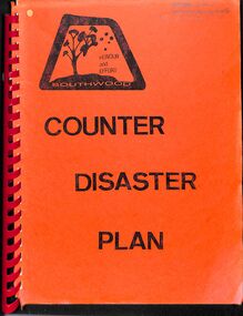
Manual, Southwood Primary School, Ringwood - Counter Disaster Plan Manual (undated - circa - post 1983) (Later version than 11626)
Bound Manual describing evacuation and emergency procedures. Includes Action Plan, Staff members, Instructions, Types of Threats and school building plan. Similar content (but later version) to VC 11626 -
 Lakes Entrance Historical Society
Book, Perrott Lyon Mathieson Pty. Ltd, Lake Tyers Beach and Surrounds Strategy Plan, 1991
A commissioned study of the Lake Tyers Beach and surrounding area prior to future planning with regard to urban development, tourism and conservation of natural beauty. Contains illustrations and a plan of proposed boat ramps.waterfront, township, tourism -
 Whitehorse Historical Society Inc.
Plan - Building Plan of Drainage, Plan of Drainage, 1939 - 1940
Plans of drainage no 204510 for Mr P. J. Markham, o & o, and W. G. Tuck, Agent. Three plans: the original proposed (31-7-1939); the approved plan (19-10-1939); and the as-built plan (10-8-1940).Three Melbourne and Metropolitan Board of Works Plans of Drainage No. 204510 for Mr. P. J. Markham, o & o, and W. G. Tuck, Agent. Municipality - Blackburn & Mitcham [of] Mitcham Post Office and residence.non-fictionPlans of drainage no 204510 for Mr P. J. Markham, o & o, and W. G. Tuck, Agent. Three plans: the original proposed (31-7-1939); the approved plan (19-10-1939); and the as-built plan (10-8-1940).mitcham post office, tuck, w. g., markham, patrick joseph, melbourne and metropolitan board of works -
 Federation University Historical Collection
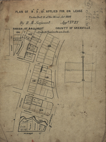
Plan, Lease Applied for by R.M. Serjeant, c1890, c1890
Plan of a lease showing streets around Skipton and Windermere Streets, Redan. Scale 4 chains to 1 inch (!:3168)serjeant, r.m.serjeant, robert m. serjeant, george street, skiptn street, windermere stret, rubicon stret, cobdon street, ascot street, lease, redan, ballarat, robert malachi serjeant, band of hope and albion mine -
 Melbourne Tram Museum
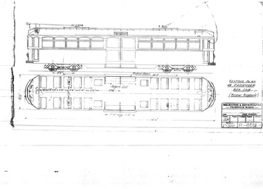
Drawing, Melbourne & Metropolitan Tramways Board (MMTB), "Seating Plan 48 passenger box car (Hopper Windows)", Aug. 1937
Print of drawing R4661, "Seating Plan 48 passenger box car (Hopper Windows)", showing a side elevation and floor plan of a tramcar like a SW6 but with two large central sliding doors.trams, tramways, sw6 class, bogie trams, new tramcars, tramcar construction, proposals -
University of Melbourne, Burnley Campus Archives
Plan, Rough Interim Plan of Agricultural College Estate Dookie, 1964
Plan of Dookie College showing buildings, numbered paddocks with acreage, other details (windmills, tanks, troughs, dams) named. Key to soil types. Dated April 1964. Scale 1 inch to 28 chains.paddocks, dookie agricultural college, soils, dookie area -
 Federation University Historical Collection
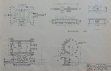
Plan, Steam Engine Cylinder - 120 hp
plan, chambers -
 Federation University Historical Collection
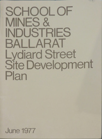
Book, School of Mines & Industries Ballarat Lydiard Streete Site Development Plan, 1977, 06/1977
Ballarat School of Mines and industry is a predecessor of Federation University Australia.Brown soft covered book of the Lydiard Street Site Development Plan.ballarat school of mines, development plan, site development, lydiard street, site influences, campus plan, ballarat school of mines campus -
Tatura Irrigation & Wartime Camps Museum
Document, Geological Plan, Eildon Dam Site, 1945
To record details of geological aspects of EildonA series of maps illustrating rock formations etc., locations, boundaries and planswater/irrigation, documents, maps -
Whitehorse Historical Society Inc.
Document, Recreation strategy plan (2004 - 2009), 1/03/2004 12:00:00 AM
Report on recreation facilities within City of Whitehorse and proposals for future planning.Report on recreation facilities within City of Whitehorse and proposals for future planning.Report on recreation facilities within City of Whitehorse and proposals for future planning.city of whitehorse, sports and recreations, sportsgrounds, sporting clubs -
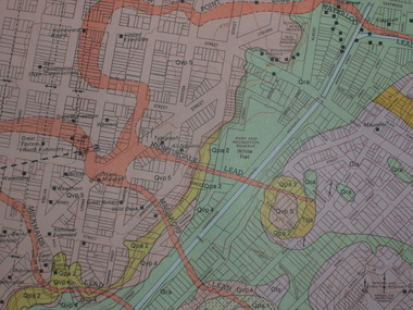
Lakes Entrance Historical Society
Book, Town and Country Planning Board Melbourne, Gippsland Lakes Land Use Strategy Plan, 1978
Background report to the strategy plan to guide future development of the Gippsland Lakeswaterways, recreation -
 Ringwood and District Historical Society
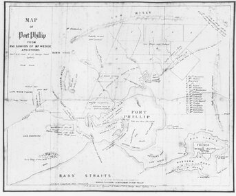
Photograph, Map of Melbourne & Vicinity - 1853. Survey of Port Phillip. Plan in Bonwick's "Settlement of Port Phillip"
Catalogue card reads, 'Map of Melbourne & Vicinity - 1853. Survey of Port Phillip. Plan in Bonwick's "Settlement of Port Phillip"'. -
Federation University Historical Collection
Book, University of Ballarat Interim Strategic Plan, 1997, 1989
A4 book compiled by the University of Ballarat Financial and Resource Services Branch. Appendices include: * Statutory requirements for Financial & Planning Services Branch * Halls of Residence Strategic Plan * Campus Amentities Strategic Plan * Finanace Database Volume Statistics * Client Survey - PLanning Services and Budgeting Services * Recent In-House I.T. Development * Processes to be investigated/Introduced Tables include: * Staffing by level, gender and age * Fianancial & Resource Services Budget, 1997 * Fianancial & Resource Services Budget, 1998 strategic plan, fiancial planning, robert hook, mission, vision, values, staffing, information technology, halls of residence, student accomodation -
University of Melbourne, Burnley Campus Archives
Work on paper (item) - Student Work, Caitlin Taylor, Luminous Landscape Design Documentation Plan, 5th November 2018
Submitted as an assignment for HORT90035, a subject at Burnley Horticultural College coordinated by Andrew Laidlaw. -
Clunes Museum
Plan - PLANS, NEW NORTH CLUNES MINE - UNDERGROUND WORKINGS
.1 HEADER PAGE: "UNDERGROUND WORKINGS - NEW NORTH CLUNES MINE" .2 PLAN .3 PLAN TRANSVERSE SECTIONS .4 PLAN LONGITUDINALSECTIONS.2 "656" PRINTED ON PLAN (FRONT)" .3 PRINTED ON PLAN R-272/.S/1B .4 R-272/S/1Aunderground workings, new north clunes mine -
 University of Melbourne, Burnley Campus Archives
Plan, Master Plan Burnley Gardens, c.1996
Plan of Burnley Gardens showing P.R.I. (Plant Research Institute) and V.C.A.H. Buildings and Open Space areas. Map used - photogrammetric plot prepared for the V.C.A.H. By Stereometric Services from aerial photography taken 10-7-1988.vcah, burnley gardens, stereometric services, master plan -
 Federation University Historical Collection
Drawing - Architectural Plan, Ballarat School of Mines Gauge Tower Architectural Plan by Henry Richards Caselli, 04/11/1880
The Ballarat School of Mines was the first of its type in Australia. The Albert Street frontage was the 'working end' of the campus with the mining laboratory, gauge tower and caretakers cottage. All the structures in the foreground have been demolished to make way for the Flecknoe Building and the M.B. John Building. The gauge tower is also depicted in the 1881 Annual Report.Original double mounted and framed architectural plan for the Ballarat School of Mines Gauge Tower. The plan includes sections and elecation. Some areas have been coloured, and the drawing is at a scale of four feet to one inch. Verso in ink "Gauge Tower School of Mines" Signed left "H.R. Caselli architect 4.11.80henry caselli, henry richards caselli, architectural plan, ballarat school of mines, gauge tower, buildings, architect -
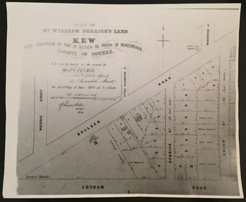 Kew Historical Society Inc
Print - Subdivision Plan, F Price, Plan of Mr William Derrick's Land, Kew being Subdivision of Part of Section 86, Parish of Boroondara, County of Bourke, 1872, 1872 [Original]
This work forms part of the collection assembled by the historian Dorothy Rogers, that was donated to the Kew Historical Society by her son John Rogers in 2015. The manuscripts, photographs, maps, and documents were sourced by her from both family and local collections or produced as references for her print publications. Many were directly used by Rogers in writing ‘Lovely Old Homes of Kew’ (1961) and 'A History of Kew' (1973), or the numerous articles on local history that she produced for suburban newspapers. Most of the photographs in the collection include detailed annotations in her hand.The Rogers Collection provides a comprehensive insight into the working habits of a historian in the 1960s and 1970s. Together it forms the largest privately-donated collection within the archives of the Kew Historical Society.A photographic reproduction of a plan in the Vale Collection of the State Library of Victoria showing William Derricks land in the area bordered by Bulleen Road (High Street); Cotham Road and Union Street. The plan dates from 1872.william derrick, subdivision plans -- kew (vic.) -
Federation University Historical Collection
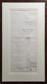
Plan, Ballarat - Mining Lease No 5611
Plan showing mining lease no 5611 along Yarrowee Creek, Ballarat. Bonshaw Pre-Emptive Right is recorded on the plan.ballarat, yarrowee, yarrowee creek, mining, mining lease, ballaarat, bonshaw, magpie, pre-emptive right -
 St Kilda Historical Society
Document, Plan of Town of Melbourne 1837 AD, 1837 (original)
Shows the outcome of the first land sales held in Melbourne, on 1 June and 1 November 1837. All the names and prices for each lot are displayed.Photocopy of "Plan of Town of Melbourne 1837 A.D." showing first land sales.All lots printed with name of buyer and price paid.melbourne - history, town of melbourne- 1837, 19th century -
Whitehorse Historical Society Inc.
Document, Office plan - 13 Walkers Road, Nunawading, 1/05/2001 12:00:00 AM
Building plan for proposed offices at 13 Walkers Rd Nunawading with draft conditions.Building plan for proposed offices at 13 Walkers Rd Nunawading with draft conditions.Building plan for proposed offices at 13 Walkers Rd Nunawading with draft conditions.plans, commercial development, walkers road, nunawading, no 13, grech, e.j. and associates -
Whitehorse Historical Society Inc.
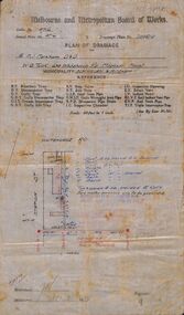
Document, Melbourne and Metropolitan Board of Works Drainage Plan, 15/09/1939 12:00:00 AM
Plan of drainage for Ethel Vanner's house at 590 Whitehorse Road, Mitcham, 1939.Plan of drainage for Ethel Vanner's house at 590 Whitehorse Road, Mitcham, 1939.Plan of drainage for Ethel Vanner's house at 590 Whitehorse Road, Mitcham, 1939.water supply, melbourne and metropolitan board of works, vanner, ethel v., whitehorse road, mitcham, no. 590 -
Whitehorse Historical Society Inc.
Document, Waste Management Plan, 1/04/1995
City of Whitehorse Waste Management Plan dated April 1995. 43 pageswaste disposal, city of whitehorse, garbage collection, incinerators -
Ballarat Heritage Services
Document, RPD, Canadian Valley Outline Development Plan, 06/2005
According to the 2001 census the Canadian Valley was home to around 7700 residents.An overall framework for future planning and management of the Canadian Valley on the southern side of Ballarat. canadian valley, mount helen, mount clear, buninyong, ballarat technology park, federation university, university of ballarat, canadian creek, urban sprawl, koala management, urbanisation, urban growth management -
 Melbourne Tram Museum
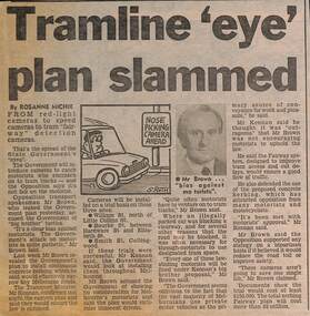
Newspaper, Herald Sun, "Tramline 'eye' plan slammed", 5-4-1989
Provides information about a proposal "speed camera" style camera for use in Fairways to detect motorists who should have not have been using the lane. Proposed by the Minister for Transport Jim Kennan, opposed by the Opposition Transport spokesman Alan Brown. Gave some proposed locations. Article written by Rosanne Michie. Yields information about a proposal to monitor compliance of Fairways,Newspaper clipping - "Tramline 'eye' plan slammed" - The Sun 5-4-1989tramways, trams, melbourne, public transport, fairways -
Lakes Entrance Historical Society
Book, Streeter Neil and Battista Marlene, East Gippsland Rail Trail Concept Plan, 1987c
Concept plan for establishment of rail trail on disused railway reserve Bairnsdale to Orbost.recreation -
Lakes Entrance Historical Society
Book, Parks Victoria Compiler, MacLeod Morass & Jones Bay Draft Management Plan 2003, 2003
A draft plan for the startegies to manage the Macleod Morass and Jones Bay Wildlife reservesenvironment, fauna, natural resources, restoration, vegetation -
Lakes Entrance Historical Society
Book, DCNR, Forest Management Plan 1995, 1995
A plan providing guidelines for the balanced use of state forests in East Gippsland Victoriaforest, conservation -
 Bendigo Military Museum
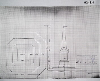
Plan - MONUMENT PLANS, 9.7.1992
All three pertain to the erection of a Monument in front of the Soldiers Memorial Institute in Pall Mall Bendigo to honour Ex Servicemen and Women. Refer Cat No 8245.2.1) Plan, white paper, black print on black graph paper showing front elevation and plan of a monument, signed, dated and stamped. .2) Plan, white paper black print showing plan and section A.A of same structure as .1). .3) Plan, white paper black print showing position of proposed monument as in .1) in front of a building with gardens surrounding. signed, dated and stamped.On all three written and stamped, " Planning and Environment Act 1987 Bendigo Planning scheme - Plan refrred to in Permit No 096/92 - Application No 096 (signature) 9.7.92 - for and on behalf of the responsible authority"brsl, smirsl, plans, monument -
 Federation University Historical Collection
Plan, Ballarat Goldfield - Geological Survey of Victoria, 1981, 1981
Coloured geological plan showing the Ballarat goldfields. It includes coloured scales and nuggets from the Ballarat Goldfield. It also shows leads and mines.ballarat, geology, geological, gold nuggets, mining, mining companies, gold leads