Showing 792 items
matching plan of kew
-
 Kew Historical Society Inc
Journal, The Kewriosity Sheet Vol.4 No.1 : August 1982
Community effort for St Paul's [School for the Blind] / p1. Annual elections for the City of Kew - North Ward [J. Ormando, P.R. Palmer]; College Ward [P.M. Tunney, P.N.V. Wallinga]; Studley Park Ward [R.E.H. Saunders, M.J. Slattery] / p1. Scrabble / p1. School Holiday Program / p1. R.A.A.V. [Rheumatism and Arthritis Association of Victoria] / p1. Early Planning for Retirement Group / p1. Calling all pioneers!!! [Kew Historical Society; Allen family] / p1. Hyde Park Fellowship [Hyde Park Uniting Church] / p2. What's doing in Kew for August / p2&3. Starlight Theatre Company presents "Gi Gi" / p3. Kew's library grows [Large print books] / p3. Remember boneseed blitz [Studley Park] / p3. "Drop in" [Kew Uniting Church] / p3. Kew Garden Club / p3. Kew Elder Citizen's Club / p3. In the Streets of Kew [transport history] / Barbara Giles p4. Play Centre [Toddler/Kindy Gym Play Centre] / p4. Native Plant Group / p4.The Kewriosity Sheet (1979-83) was first published in the City of Kew (Victoria) in June 1979 as a two-sided 'community newssheet'. It aimed to: 'share news about Kew happenings and Kew people, and to exchange ideas about living in Kew'. Later issues gradually evolved into a 4-page, quarto sized publication. The Kewriosity Sheet was superseded by the Kew Council publication 'Kewriosity' (1983-1994).non-fictionCommunity effort for St Paul's [School for the Blind] / p1. Annual elections for the City of Kew - North Ward [J. Ormando, P.R. Palmer]; College Ward [P.M. Tunney, P.N.V. Wallinga]; Studley Park Ward [R.E.H. Saunders, M.J. Slattery] / p1. Scrabble / p1. School Holiday Program / p1. R.A.A.V. [Rheumatism and Arthritis Association of Victoria] / p1. Early Planning for Retirement Group / p1. Calling all pioneers!!! [Kew Historical Society; Allen family] / p1. Hyde Park Fellowship [Hyde Park Uniting Church] / p2. What's doing in Kew for August / p2&3. Starlight Theatre Company presents "Gi Gi" / p3. Kew's library grows [Large print books] / p3. Remember boneseed blitz [Studley Park] / p3. "Drop in" [Kew Uniting Church] / p3. Kew Garden Club / p3. Kew Elder Citizen's Club / p3. In the Streets of Kew [transport history] / Barbara Giles p4. Play Centre [Toddler/Kindy Gym Play Centre] / p4. Native Plant Group / p4. community publications --- kew (vic.), the kewriosity sheet, newsletters - kew (vic.) -
Kew Historical Society Inc
Journal, The Kewriosity Sheet Vol.4 No.4 : November 1982
Kew Philharmonic Orchestra / p1. Kew Garden Club / p1. Native Plant Group / p1. Early Planning for Retirement Group / p1. An Advent Carol Service [The Ministers of the Kew Fraternal; Trinity Grammar School] / p1. Kew Library / p1. 66th anniversary of Hyde Park Uniting Church] / p2. Hyde Park Fellowship [Hyde Park Uniting Church] / p2. What's doing in Kew for November / p2&3. Trash and Treasure [Holy Trinity] / p3. Toddler-Kindy Play Gym [Group] / p3. East Kew Bowling Club / p3. Inner East Foster Care [Agency] / p3. School Fair [East Kew Primary School] / p3. The Way We Were [Kew history] / Barbara Giles p4. Building confidence through movement / p4. Exercise the rhythmic way [Rosemary Smart] / p4.The Kewriosity Sheet (1979-83) was first published in the City of Kew (Victoria) in June 1979 as a two-sided 'community newssheet'. It aimed to: 'share news about Kew happenings and Kew people, and to exchange ideas about living in Kew'. Later issues gradually evolved into a 4-page, quarto sized publication. The Kewriosity Sheet was superseded by the Kew Council publication 'Kewriosity' (1983-1994).non-fictionKew Philharmonic Orchestra / p1. Kew Garden Club / p1. Native Plant Group / p1. Early Planning for Retirement Group / p1. An Advent Carol Service [The Ministers of the Kew Fraternal; Trinity Grammar School] / p1. Kew Library / p1. 66th anniversary of Hyde Park Uniting Church] / p2. Hyde Park Fellowship [Hyde Park Uniting Church] / p2. What's doing in Kew for November / p2&3. Trash and Treasure [Holy Trinity] / p3. Toddler-Kindy Play Gym [Group] / p3. East Kew Bowling Club / p3. Inner East Foster Care [Agency] / p3. School Fair [East Kew Primary School] / p3. The Way We Were [Kew history] / Barbara Giles p4. Building confidence through movement / p4. Exercise the rhythmic way [Rosemary Smart] / p4. community publications --- kew (vic.), the kewriosity sheet, newsletters - kew (vic.) -
Kew Historical Society Inc
Journal, The Kewriosity Sheet Vol.4 No.6 : February 1983
Kew Recreation Program / p1&2. [1983] Kew Festival / p1. East Kew Uniting Church / p1. Emergency overnight accommodation/ Foster care for children [Greek Orthodox Community) / p2. What's doing in Kew for February / p2&3. Kew Garden Club / p3. Kew (Daytime) Gardening Club / p3. Native Plant Group / p3. Are you interested in poetry / p3. Scrabble / p3. Save the Children Fund / p3. Institute of Early Childhood Development (short courses) / p4. Make Today Count (health & wellbeing) / p4. Kew Library (family history; genealogy) / p4. Hyde Park Fellowship (Hyde Park Uniting Church) / p4. Early Planning for Retirement Group / p4. Uniting Church East Kew / p4.The Kewriosity Sheet (1979-83) was first published in the City of Kew (Victoria) in June 1979 as a two-sided 'community newssheet'. It aimed to: 'share news about Kew happenings and Kew people, and to exchange ideas about living in Kew'. Later issues gradually evolved into a 4-page, quarto sized publication. The Kewriosity Sheet was superseded by the Kew Council publication 'Kewriosity' (1983-1994).non-fictionKew Recreation Program / p1&2. [1983] Kew Festival / p1. East Kew Uniting Church / p1. Emergency overnight accommodation/ Foster care for children [Greek Orthodox Community) / p2. What's doing in Kew for February / p2&3. Kew Garden Club / p3. Kew (Daytime) Gardening Club / p3. Native Plant Group / p3. Are you interested in poetry / p3. Scrabble / p3. Save the Children Fund / p3. Institute of Early Childhood Development (short courses) / p4. Make Today Count (health & wellbeing) / p4. Kew Library (family history; genealogy) / p4. Hyde Park Fellowship (Hyde Park Uniting Church) / p4. Early Planning for Retirement Group / p4. Uniting Church East Kew / p4.community publications --- kew (vic.), the kewriosity sheet, newsletters - kew (vic.) -
Kew Historical Society Inc
Journal, The Kewriosity Sheet Vol.4 No.11 : July 1983
... planning; Louis Kahan - Kew Synagogue windows) / p3. C.A.B ...Art exhibition: Trinity Grammar School / p1. A new Musical at St Hilary's Kew ('Rocky & the Bloke' / p1. Visitors welcome (Rheumatism and Arthritis Association of Victoria) / p1. Uniting Church Congregational Casserole Dinner / p2. 1st Kew Scout Group bottle recycling depot change / p2. Native Plant Group / p2. Save the Children Fund / p2. Kew Citizens' Advice Bureau / p2. Kew Historical Society / p2. Kew Library (displays) / p2. Billabong Club for boys and girls primary school age (Kew Baptist Church) / p2. Th treasures of our city (Villa Alba; Historic houses; Heritage planning; Louis Kahan - Kew Synagogue windows) / p3. C.A.B. volunteers need (Citizens' Advice Bureau) / p3. Daytime Garden Club / p3. East Kew Uniting Church (calendar of events) / p4. Kew Garden Club / p4. Evening Mission Group (Kew Uniting Church) / p4. Hyde Park Fellowship (Hyde Park Uniting Church) / p4. 'Rotaract Rave' / p4. Scrabble / p4.The Kewriosity Sheet (1979-83) was first published in the City of Kew (Victoria) in June 1979 as a two-sided 'community newssheet'. It aimed to: 'share news about Kew happenings and Kew people, and to exchange ideas about living in Kew'. Later issues gradually evolved into a 4-page, quarto sized publication. The Kewriosity Sheet was superseded by the Kew Council publication 'Kewriosity' (1983-1994).non-fictionArt exhibition: Trinity Grammar School / p1. A new Musical at St Hilary's Kew ('Rocky & the Bloke' / p1. Visitors welcome (Rheumatism and Arthritis Association of Victoria) / p1. Uniting Church Congregational Casserole Dinner / p2. 1st Kew Scout Group bottle recycling depot change / p2. Native Plant Group / p2. Save the Children Fund / p2. Kew Citizens' Advice Bureau / p2. Kew Historical Society / p2. Kew Library (displays) / p2. Billabong Club for boys and girls primary school age (Kew Baptist Church) / p2. Th treasures of our city (Villa Alba; Historic houses; Heritage planning; Louis Kahan - Kew Synagogue windows) / p3. C.A.B. volunteers need (Citizens' Advice Bureau) / p3. Daytime Garden Club / p3. East Kew Uniting Church (calendar of events) / p4. Kew Garden Club / p4. Evening Mission Group (Kew Uniting Church) / p4. Hyde Park Fellowship (Hyde Park Uniting Church) / p4. 'Rotaract Rave' / p4. Scrabble / p4. community publications --- kew (vic.), the kewriosity sheet, newsletters - kew (vic.) -
 Kew Historical Society Inc
Photograph - Flood at Fairfield Park, 1934
Flooding of the Yarra Valley, including that section of the Yarra bordering Kew and Kew East in the north and west of the municipality, was a regular occurrence. Extreme flood events of the Yarra River are recorded to have occurred in 1891, 1901, 1916, 1923 and 1934. The Municipality of Kew's response to these floods was to enact planning decisions restricting residential development in flood prone areas following the floods of 1916, 1921 and 1934. While floods continued after the development of the Upper Yarra Reservoir (construction 1948-57), the regularity and extent of these inundations diminished.Black and white print positive. Yarra River at Fairfield in 1934. Major flood resulting in submerged buildings in middle ground and onlookers on far bankReverse: "Flood of Yarra at Fairfield Park 1934"fairfield park, yarra valley, river yarra, floods -- 1934 -
 Kew Historical Society Inc
Photograph - Yarra in Flood, 1934
Flooding of the Yarra Valley, including that section of the Yarra bordering Kew and Kew East in the north and west of the municipality, was a regular occurrence. Extreme flood events of the Yarra River are recorded to have occurred in 1891, 1901, 1916, 1923 and 1934. The Municipality of Kew's response to these floods was to enact planning decisions restricting residential development in flood prone areas following the floods of 1916, 1921 and 1934. While floods continued after the development of the Upper Yarra Reservoir (construction 1948-57), the regularity and extent of these inundations diminished.Black and white print positive. 1934 floods of the Yarra Valley. Location Fairfield looking towards wooded hillside. Houses floating in river.Reverse: "From Fairfield Park (11936?) back towards hill (Wurundjeri Spur?)"floods -- 1934, yarra valley, yarra river, fairfield park -
Kew Historical Society Inc
Flyer - 60 Pakington Street, Kew
... Subdivision plans and real estate flyers/brochures reveal... to the Society by the former City of Kew, a number of other plans ...Subdivision plans and real estate flyers/brochures reveal a number of aspects of urban development and history. The Kew Historical Society's collection of these plans, as well as advertisements extracted from magazines, cover key aspects of community development and architectural history of Kew and Kew Eat as well as surrounding suburbs. While most of the plans in the collection were gifted to the Society by the former City of Kew, a number of other plans and advertisements have been donated by individuals, of which this is an example. Single page illustrated flyer, advertising 60 Pakington Street, Kew for sale. Annotation in pen and ink at right.neville collection, 60 pakington street -- kew (vic.), real estate advertisements -- kew (vic.) -
Kew Historical Society Inc
Flyer - 45 Pakington Street, Kew
... Subdivision plans and real estate flyers/brochures reveal... to the Society by the former City of Kew, a number of other plans ...Subdivision plans and real estate flyers/brochures reveal a number of aspects of urban development and history. The Kew Historical Society's collection of these plans, as well as advertisements extracted from magazines, cover key aspects of community development and architectural history of Kew and Kew Eat as well as surrounding suburbs. While most of the plans in the collection were gifted to the Society by the former City of Kew, a number of other plans and advertisements have been donated by individuals, of which this is an example.Single page illustrated real estate flyer advertising 45 Pakington Street, Kew for sale by auction. Annotation in pen and ink at rightpeter neville, real estate advertisements -- kew (vic.), 45 pakington street -- kew (vic.) -
Kew Historical Society Inc
Plan - Tramway Estate, Camberwell North, 1937
... Subdivision plans and real estate flyers/brochures reveal... to the Society by the former City of Kew, a number of other plans ...Subdivision plans and real estate flyers/brochures reveal a number of aspects of urban development and history. The Kew Historical Society's collection of these plans, as well as advertisements extracted from magazines, cover key aspects of community development and architectural history of Kew and Kew Eat as well as surrounding suburbs. While most of the plans in the collection were gifted to the Society by the former City of Kew, a number of other plans and advertisements have been donated by individuals, of which this is an example.Single page subdivision plan listing properties for sale in the Tramways Estate, Camberwell North. The large estate was bounded by Doncaster Road, Burke Road, Marwan Avenue, Maud Street, Severn Street, and extended over Glass's Creek at Mayland's Avenue. Within the plan, lots 3 to 342 are listed as lots. The plan includes annotations in ink indicating the prices realised by a number of lots. A key explains that lots with an 'H' represent a house, whereas the 37 shaded lots represent those being offered by this agent. subdivision plans -- camberwell (vic.), tramways estate -
Kew Historical Society Inc
Plan - Subdivisional Sale of 11 Villa Sites, East Kew, 1939
... Subdivision plans and real estate flyers/brochures reveal... to the Society by the former City of Kew, a number of other plans ...Subdivision plans and real estate flyers/brochures reveal a number of aspects of urban development and history. The Kew Historical Society's collection of these plans, as well as advertisements extracted from magazines, cover key aspects of community development and architectural history of Kew and Kew Eat as well as surrounding suburbs. While most of the plans in the collection were gifted to the Society by the former City of Kew, a number of other plans and advertisements have been donated by individuals, of which this is an example.Single page residential subdivision plan advertising house lots for sale, in what was then designated as East Kew but is now Kew, in the following streets: Burke Road, Enfield Street. The flyer includes a smaller locality plan at right. Information on the flyer indicates that the land was previously owned by the Melbourne & Metropolitan Tramways Board.subdivision plans -- kew (vic.), enfield street -- kew (vic.), burke road -- kew (vic.) -
Kew Historical Society Inc
Plan - Camberwell Panorama Estate, 1923
... Subdivision plans and real estate flyers/brochures reveal... to the Society by the former City of Kew, a number of other plans ...Subdivision plans and real estate flyers/brochures reveal a number of aspects of urban development and history. The Kew Historical Society's collection of these plans, as well as advertisements extracted from magazines, cover key aspects of community development and architectural history of Kew and Kew Eat as well as surrounding suburbs. While most of the plans in the collection were gifted to the Society by the former City of Kew, a number of other plans and advertisements have been donated by individuals, of which this is an example.Promotional brochure for the Camberwell Panorama Estate. The four page bifold handout advertises 216 home sites bounded by Bulleen Road, The Nook, Fortuna Avenue, and Doncaster Road. Other streets in the subdivision include: Sunburst Avenue, The Moor, and Macedon Avenue. The brochure has been damaged at some time in the past and so masking tape obscures the tram on page 1. Page 2 includes the plan of the subdivision, page 3 information about the site and a locality plan, while page 4 includes photographs and terms of sale. subdivision plans -- balwyn north (vic.), camberwell panorama estate -
Kew Historical Society Inc
Plan - Saxonwood Estate, Doncaster [East]
... Subdivision plans and real estate flyers/brochures reveal... to the Society by the former City of Kew, a number of other plans ...Subdivision plans and real estate flyers/brochures reveal a number of aspects of urban development and history. The Kew Historical Society's collection of these plans, as well as advertisements extracted from magazines, cover key aspects of community development and architectural history of Kew and Kew Eat as well as surrounding suburbs. While most of the plans in the collection were gifted to the Society by the former City of Kew, a number of other plans and advertisements have been donated by individuals, of which this is an example.Undated, multi-page subdivision plan advertising lots for sale bounded by Blackburn Road, George Street, Windermere Avenue, and Saxonwood Drive in what is currently Doncaster East. Other streets in the subdivision include: Mowbray Court, Stafford Court, Rugby Court, and Robin Hood Court. The front page includes a Birdseye view of the estate which identifies existing and projected civic amenities, as well as the estate's relationship to surrounding suburbs and the city centre. Red crosses on the detailed plan of lots on page two indicate those that have been sold. The final page includes a locality plan. saxonwood estate -- doncaster east (vic.), subdivision plans -- doncaster east (vic.) -
Kew Historical Society Inc
Plan - Charteris Estate, Ivanhoe [East], 1927
... Subdivision plans and real estate flyers/brochures reveal... to the Society by the former City of Kew, a number of other plans ...Subdivision plans and real estate flyers/brochures reveal a number of aspects of urban development and history. The Kew Historical Society's collection of these plans, as well as advertisements extracted from magazines, cover key aspects of community development and architectural history of Kew and Kew Eat as well as surrounding suburbs. While most of the plans in the collection were gifted to the Society by the former City of Kew, a number of other plans and advertisements have been donated by individuals, of which this is an example.Original 4-page bifold handout advertising 43 residential lots for sale in the Charteris Estate subdivision in Ivanhoe [now classified as Ivanhoe East]. This brochure was created to sell the third section of the estate which it labels as 'The Most Superb Section'. Streets within the subdivision include: Burke Road North, McArthur Road, Castella Street, and the Government Boulevard. In addition to the overall plan spread across pages 2 and 3, each page includes a number of interesting photographs including: a number of the new Burke Road Bridge, a sports ground, Hoyts Picture Theatre in Ivanhoe, a croquet ground, and Ivanhoe shopping centre [named Motor Cross Junction].charteris estate - east ivanhoe (vic), subdivision plans -- ivanhoe east (vic.), d.c. mcarthur, charterisville -
Kew Historical Society Inc
Plan - Pointed Firs Estate, Camberwell North, 1936
... Subdivision plans and real estate flyers/brochures reveal... to the Society by the former City of Kew, a number of other plans ...Subdivision plans and real estate flyers/brochures reveal a number of aspects of urban development and history. The Kew Historical Society's collection of these plans, as well as advertisements extracted from magazines, cover key aspects of community development and architectural history of Kew and Kew Eat as well as surrounding suburbs. While most of the plans in the collection were gifted to the Society by the former City of Kew, a number of other plans and advertisements have been donated by individuals, of which this is an example.Original multi-page sales brochure of the Pointed Firs Estate, advertised as located in Camberwell North, but now in Balwyn North. The 4-page bifold brochure includes promotional material as well as a detailed plan of the 28 lots for sale, a photograph of the locality with the plan overlaying it, as well as aerial photos and street views. The estate included lots in Doncaster Road, Thackeray Street, Houghton Street, an dMaud Street. pointed firs estate -- balwyn north, subdivisions -- balwyn north (vic.) -
Kew Historical Society Inc
Booklet - Old Kew Golf Links Estate, 1926
... Subdivision plans and real estate flyers/brochures reveal... to the Society by the former City of Kew, a number of other plans ...Subdivision plans and real estate flyers/brochures reveal a number of aspects of urban development and history. The Kew Historical Society's collection of these plans, as well as advertisements extracted from magazines, cover key aspects of community development and architectural history of Kew and Kew Eat as well as surrounding suburbs. While most of the plans in the collection were gifted to the Society by the former City of Kew, a number of other plans and advertisements have been donated by individuals, of which this is an example.8-page brochure advertising 80 residential home sites for sale in a subdivision called the 'Old Kew Golf Links Estate'. These sites had historic importance in Kew's history as they had previously belonged to Kodak Pty Ltd who were refused permission by Kew Council to use the land for industrial development. The estate, advertised was advertised as being within five miles of Melbourne. The brochure is notable as it includes photographs of Kew East Primary School, the former Kew Golf Club clubhouse, and 'The Moorings' Boathouse (aka Chipperfield's Boat House). The aerial photograph, overlaid with names of notable sites, on the final page is of interest as it shows the area before the intrusion of the Eastern Freeway, which resulted in changing the course of a section of the Yarra River. old kew golf links estate, subdivision -- kew (vic.), subdivisions -- kew east (vic), chipperfield's boathouse, kew east primary school, kew golf club -
Kew Historical Society Inc
Plan - Willsmere Park Estate, Kew, 1926
... Subdivision plans and real estate flyers/brochures reveal... to the Society by the former City of Kew, a number of other plans ...Subdivision plans and real estate flyers/brochures reveal a number of aspects of urban development and history. The Kew Historical Society's collection of these plans, as well as advertisements extracted from magazines, cover key aspects of community development and architectural history of Kew and Kew Eat as well as surrounding suburbs. While most of the plans in the collection were gifted to the Society by the former City of Kew, a number of other plans and advertisements have been donated by individuals, of which this is an example.Original 4-page, bifold subdivision plan of the Willsmere Park Estate, Kew. The 1926 land sale advertised '40 superb villa allotments' on the 'Yarra Heights'. Streets within the subdivision included: Willow Grove, Kilby Road, Elm Grove and Belford Road. The double page spread on pages 2 and 3 shows the detailed plan of the 40 lots, surrounded by public parkland [Willsmere Park] and the Kew Golf Links. By the time that this version of the plan was released, only the lots on Willow Grove and Kilby Road remained. willsmere park estate -- kew (vic.), subdivisions - kew (vic.), subdivisions -- kew east (vic.), willsmere park -- kew east (vic.) -
Kew Historical Society Inc
Booklet - Yarraleen Estate, Bulleen, c.1966
... Subdivision plans and real estate flyers/brochures reveal... to the Society by the former City of Kew, a number of other plans ...Subdivision plans and real estate flyers/brochures reveal a number of aspects of urban development and history. The Kew Historical Society's collection of these plans, as well as advertisements extracted from magazines, cover key aspects of community development and architectural history of Kew and Kew Eat as well as surrounding suburbs. While most of the plans in the collection were gifted to the Society by the former City of Kew, a number of other plans and advertisements have been donated by individuals, of which this is an example.Original 8-page booklet advertising a new residential development in Bulleen entitled 'Yarraleen'. The glossy multi-colour brochure includes historic and contemporary photographs of the Yarra Valley, graphic designs of potential residential development, photographs of key facilities (Marcellin College, Golf links, local swimming holes, the Beaver Swim School, Carey Grammar School Oval and grandstand, shopping strips, and farmland).subdivisions -- bulleen (vic.), yarraleen estate -
Kew Historical Society Inc
Plan - 30 Choice Home Sites in Kilby Road, Meldrum Street and Fairway Drive, 1965
... Subdivision plans and real estate flyers/brochures reveal... to the Society by the former City of Kew, a number of other plans ...Subdivision plans and real estate flyers/brochures reveal a number of aspects of urban development and history. The Kew Historical Society's collection of these plans, as well as advertisements extracted from magazines, cover key aspects of community development and architectural history of Kew and Kew Eat as well as surrounding suburbs. While most of the plans in the collection were gifted to the Society by the former City of Kew, a number of other plans and advertisements have been donated by individuals, of which this is an example.Original 4-page, bifold brochure, one of two in the collection, of home sites created following the creation of the Eastern Freeway which separated a section of land owned by the Kew Golf Club from the main course. The new estate featured 30 lots in Meldrum Street, Kilby Road and Fairway Drive. subdivisions -- kew east (vic.), subdivisions -- kew (vic.), kew golf club -
Kew Historical Society Inc
Plan - 30 Choice Home Sites in Kilby Road, Meldrum Street and Fairway Drive, 1965
... Subdivision plans and real estate flyers/brochures reveal... to the Society by the former City of Kew, a number of other plans ...Subdivision plans and real estate flyers/brochures reveal a number of aspects of urban development and history. The Kew Historical Society's collection of these plans, as well as advertisements extracted from magazines, cover key aspects of community development and architectural history of Kew and Kew Eat as well as surrounding suburbs. While most of the plans in the collection were gifted to the Society by the former City of Kew, a number of other plans and advertisements have been donated by individuals, of which this is an example.Original 4-page, bifold brochure, one of two in the collection, of home sites created following the creation of the Eastern Freeway which separated a section of land owned by the Kew Golf Club from the main course. The new estate featured 30 lots in Meldrum Street, Kilby Road and Fairway Drive.subdivisions -- kew east (vic.), subdivisions -- kew (vic.), kew golf club -
Kew Historical Society Inc
Plan - Burke Road Junction Estate, East Kew, 1940
... Subdivision plans and real estate flyers/brochures reveal... to the Society by the former City of Kew, a number of other plans ...Subdivision plans and real estate flyers/brochures reveal a number of aspects of urban development and history. The Kew Historical Society's collection of these plans, as well as advertisements extracted from magazines, cover key aspects of community development and architectural history of Kew and Kew Eat as well as surrounding suburbs. While most of the plans in the collection were gifted to the Society by the former City of Kew, a number of other plans and advertisements have been donated by individuals, of which this is an example.Original 4-page bifold brochure advertising the Burke Road Junction Estate in Kew East. Advertised for sale in 1940, the estate comprised 16 'Central Allotments' fronting High Street, Kilby Road, and Glass Street. Pages 1 & 4, the front and back covers, includes a panoramic photograph of the junction which features a number of shops still extant, but also with buildings long demolished and redeveloped. These include the petrol station and the dairy on the southeast and southwest corners of Burke Road and High Street/Doncaster Road. The dairy includes a statue of a cow on its roof. Pages 2 & 3 include a detailed plan of the estate. subdivisions -- kew east (vic.), burke road junction estate -
 Kew Historical Society Inc
Photograph - River Yarra in Flood from Kilby Road
Flooding of the Yarra Valley, including that section of the Yarra bordering Kew and Kew East in the north and west of the municipality, was a regular occurrence. Extreme flood events of the Yarra River are recorded to have occurred in 1891, 1901, 1916, 1923 and 1934. The Municipality of Kew's response to these floods was to enact planning decisions restricting residential development in flood prone areas following the floods of 1916, 1921 and 1934. While floods continued after the development of the Upper Yarra Reservoir (construction 1948-57), the regularity and extent of these inundations diminished.Print copy of an original photo of the River Yarra in Flood, taken from Kilby Road.VIEW ACROSS YARRA IN FLOOD / FROM KILBY RD KEWkilby road, floods -- kew (vic.), kilby farm -
Kew Historical Society Inc
Collection, Floods in North Kew (Series), 1929–1934
Flooding of the Yarra Valley, including that section of the Yarra bordering Kew and Kew East in the north and west of the municipality, was a regular occurrence. Extreme flood events of the Yarra River are recorded to have occurred in 1891, 1901, 1916, 1923 and 1934. The Municipality of Kew's response to these floods was to enact planning decisions restricting residential development in flood prone areas following the floods of 1916, 1921 and 1934. While floods continued after the development of the Upper Yarra Reservoir (construction 1948-57), the regularity and extent of these inundations diminished. Natural disasters had an impact on the development and settlement of Melbourne and its suburbs. Flooding in the Melbourne region was a regular event in the nineteenth and for most of the twentieth centuries. Changes in the impact of natural disasters could occur due to a number of factors. This collection of small snapshots, mostly taken from Kellett Grove in North Kew, provide provenanced evidence of flooding in the area before the development of the unnatural flood barrier that is the Eastern Freeway.Collection of 16 monochrome photographs, annotated on verso by different hands, of the flooding of the River Yarra in North Kew in the third and fourth decades of the twentieth century [1920s & 1930s]. Individual photos include the dates of different floods. Many of the photos were taken from the rear of 8 Kellett Grove; a house still extant in 2023yarra river -- north kew, floods -- yarra valley, floods -- north kew, floods -- 1929, floods -- 1934, natural disasters -- kew -
![Giant Red Gum. Victoria Park [Kew]](/media/collectors/550653872162f11fb04854aa/items/658f5e1a101c4283c6ae8194/item-media/658f5e76101c4283c6ae8404/item-fit-380x285.jpg) Kew Historical Society Inc
Kew Historical Society IncPhotograph - Giant Red Gum. Victoria Park [Kew], c.1950
In 1871, Victoria Park, beside the Boroondara General Cemetery was set aside as a public reserve. As the Park developed, exotic plants were added to existing specimens. In 1910, a photograph of ‘The Oldest Inhabitant: A Giant Red-gum Tree’ in the Park was included in the Jubilee History of Kew. Fifty-one years later the tree was re-photographed by Colin Campbell. A 2007 Master Plan developed for the City of Boroondara advises the retention of this now dead River Red Gum, including a ‘managed risk zone’ and planting under the heavily lopped tree.This work forms part of the collection assembled by the historian Dorothy Rogers (1905-1973), donated to the Kew Historical Society by her son in 2015. The manuscripts, photographs, maps, and documents were sourced by her from both family and local collections or produced as references for her print publications. Many were directly used by Rogers in writing ‘Lovely Old Homes of Kew’ (1961) and 'A History of Kew' (1973), or the numerous articles on local history that she produced for suburban newspapers. Most of the photographs in the collection include detailed annotations in her hand. The Rogers Collection provides a comprehensive insight into the working habits of a historian from the 1960s to the 1970s. Small monochrome snapshot of the former giant River Red Gum that until it died was a major feature of Victoria Park, Kew. In the background is the red brick wall of the Boroondara General (Kew) Cemetery.Annotation verso: "Giant Red Gum. Victoria Park. Still there over 100 yrs old"dorothy rogers, victoria park (kew), river red gums -
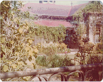 Kew Historical Society Inc
Photograph - 'Mynda', 5 Molesworth Street, 1979
'A suburban villa of 1885 designed by Lloyd Tayler for his daughter and son-in-law on a plan centred upon an octagonal top-lit hall. A square bay window to the drawing room projects from the front corner of the house at 45 degress, showing for the first time the diagonal emphasis which was to be developed in other works of the architect and to become in due course a characteristic of the Federation Style.' (National Trust Victoria Citation)Original colour positive photograph (Kodak print) of the front garden of 'Mynda', 5 Molesworth Street, KewInk on reverse: "Miss Anderson's / No.5 Molesworth St. / Cottage garden / Taken and ***"historic gardens -- kew (vic.), mynda, 5 molesworth street -- kew (vic.) -
Kew Historical Society Inc
Archive (series) - Subject File, Maps and plans, 1838-1998
... Kew Historical Society Inc 1 Civic Drive Kew melbourne Maps ...Reference, Research, InformationSecondary Values (KHS Imposed Order)Subject file containing a range of maps from different historical periods. Some have newspaper articles with background historical information. Some are maps produced by the MMBW, Members of Parliament, Melways, and hand-drawn maps locating where buildings, people and places were formerly in evidence. -
![Wallpaper from 'Reno', St John's Parade [Kew]](/media/collectors/550653872162f11fb04854aa/items/57975996d0cdd1098c81d980/item-media/579759ded0cdd1098c81f6fa/item-fit-380x285.jpg) Kew Historical Society Inc
Kew Historical Society IncDecorative object - Wallpaper sample from 'Reno', St John's Parade, 1890s
Comparatively few weatherboard houses in Kew survived from the early years of settlement into the second half of the 20th century. One such property was ‘Reno’, which once stood on the east side of St John’s Parade. Its earliest recorded owner was the architect Samuel Cocking who lived there from c.1865 until his death in 1888. The original landholding was bordered by Cotham Road, Glenferrie Road, Wellington Street, and Charles Street. The southern portion of this land included a fine orchard, with many imported trees. The old summer house, at first in the orchard, was later removed to the house garden. The MMBW Detail Plan No.1576 (1904) shows the remaining portion of the original land holding, including a semi-circular pathway at the front, and garden features such as an aviary, a fountain and grotto, and a fernery. None of these are apparent in photographs dating from the 1960s, where the garden, which once included rare plants provided by Baron Von Mueller, surrounds the cottage in a tangled frenzy. Despite a ‘local significance’ classification by the National Trust, the house was demolished in 1977. Wallpaper fragment from ‘Reno’. This small fragment of floral wall paper is a bolder design than the delicately drawn flowers in 1977.0005.1. The flowers in this example were impressionistically created using printing blocks that allowed for different thicknesses of paint to be applied in the hand-blocking process. wallpaper, reno, st john's parade, kew -
![Wallpaper from 'Reno', St John's Parade [Kew]](/media/collectors/550653872162f11fb04854aa/items/57975a62d0cdd1098c8232a8/item-media/57975cabd0cdd1098c836f91/item-fit-380x285.jpg) Kew Historical Society Inc
Kew Historical Society IncDecorative object - Wallpaper sample from 'Reno', St John's Parade, 1870s
Comparatively few weatherboard houses in Kew survived from the early years of settlement into the second half of the 20th century. One such property was ‘Reno’, which once stood on the east side of St John’s Parade. Its earliest recorded owner was the architect Samuel Cocking who lived there from c.1865 until his death in 1888. The original landholding was bordered by Cotham Road, Glenferrie Road, Wellington Street, and Charles Street. The southern portion of this land included a fine orchard, with many imported trees. The old summer house, at first in the orchard, was later removed to the house garden. The MMBW Detail Plan No.1576 (1904) shows the remaining portion of the original land holding, including a semi-circular pathway at the front, and garden features such as an aviary, a fountain and grotto, and a fernery. None of these are apparent in photographs dating from the 1960s, where the garden, which once included rare plants provided by Baron Von Mueller, surrounds the cottage in a tangled frenzy. Despite a ‘local significance’ classification by the National Trust, the house was demolished in 1977.Wallpaper fragment from ‘Reno’. This large single example is interesting as it represents a change in fashion and style from the finely drawn flowers (1971.0002.1) of an older paper, parts of which can be seen behind this sample. Typically the updating of wallpapers was accomplished by laying a new paper over the old. The ‘newer’ wallpaper is of a single colour, the tone of which may have suffered from colour distortion due to ageing. The new block-printed design, featuring repeated sprays of flowers and leaves combines a bold use of colour with an elegance of design.reno, st john's parade, kew, samuel cocking, wallpaper -
![Wallpaper fragment - Reno, St John's Parade [Kew]](/media/collectors/550653872162f11fb04854aa/items/57975cd6d0cdd1098c838ddb/item-media/57975d42d0cdd1098c83c222/item-fit-380x285.jpg) Kew Historical Society Inc
Kew Historical Society IncDecorative object - Wallpaper sample from 'Reno', St John's Parade, 1870s
Comparatively few weatherboard houses in Kew survived from the early years of settlement into the second half of the 20th century. One such property was ‘Reno’, which once stood on the east side of St John’s Parade. Its earliest recorded owner was the architect Samuel Cocking who lived there from c.1865 until his death in 1888. The original landholding was bordered by Cotham Road, Glenferrie Road, Wellington Street, and Charles Street. The southern portion of this land included a fine orchard, with many imported trees. The old summer house, at first in the orchard, was later removed to the house garden. The MMBW Detail Plan No.1576 (1904) shows the remaining portion of the original land holding, including a semi-circular pathway at the front, and garden features such as an aviary, a fountain and grotto, and a fernery. None of these are apparent in photographs dating from the 1960s, where the garden, which once included rare plants provided by Baron Von Mueller, surrounds the cottage in a tangled frenzy. Despite a ‘local significance’ classification by the National Trust, the house was demolished in 1977. Wallpaper fragment from ‘Reno’. These three boldly designed samples from a single room are in shades of green and brown, highlighted by yellow and red floral sprays. While more accurately printed and coloured, the fragment lacks the freedom of design of the earlier samples.wallpaper, reno, st john's parade, kew, samuel cocking -
![Reno, St John's Parade [Kew] - Reno, St John's Parade [Kew]](/media/collectors/550653872162f11fb04854aa/items/57975dcbd0cdd1098c840aaf/item-media/57975e31d0cdd1098c84343d/item-fit-380x285.jpg) Kew Historical Society Inc
Kew Historical Society IncDecorative object - Wallpaper samples from 'Reno', St John's Parade, 1880-1910
Comparatively few weatherboard houses in Kew survived from the early years of settlement into the second half of the 20th century. One such property was ‘Reno’, which once stood on the east side of St John’s Parade. Its earliest recorded owner was the architect Samuel Cocking who lived there from c.1865 until his death in 1888. The original landholding was bordered by Cotham Road, Glenferrie Road, Wellington Street, and Charles Street. The southern portion of this land included a fine orchard, with many imported trees. The old summer house, at first in the orchard, was later removed to the house garden. The MMBW Detail Plan No.1576 (1904) shows the remaining portion of the original land holding, including a semi-circular pathway at the front, and garden features such as an aviary, a fountain and grotto, and a fernery. None of these are apparent in photographs dating from the 1960s, where the garden, which once included rare plants provided by Baron Von Mueller, surrounds the cottage in a tangled frenzy. Despite a ‘local significance’ classification by the National Trust, the house was demolished in 1977.Wallpaper fragment from ‘Reno’. These two large fragments of wallpaper have a formality of design that is accentuated by the wide borders and narrow vertical lines that separate the repeated designs of rose garlands in vases on a vertical trellis design. The design is in tones of pink and green with gilding.reno, st john's parade, kew, samuel cocking, wallpaper -
![Wallpaper from 'Reno', St John's Parade [Kew]](/media/collectors/550653872162f11fb04854aa/items/57975eabd0cdd1098c846619/item-media/57975ee7d0cdd1098c8484f7/item-fit-380x285.jpg) Kew Historical Society Inc
Kew Historical Society IncDecorative object - Wallpaper samples from 'Reno', St John's Parade, 1880-1914
Comparatively few weatherboard houses in Kew survived from the early years of settlement into the second half of the 20th century. One such property was ‘Reno’, which once stood on the east side of St John’s Parade. Its earliest recorded owner was the architect Samuel Cocking who lived there from c.1865 until his death in 1888. The original landholding was bordered by Cotham Road, Glenferrie Road, Wellington Street, and Charles Street. The southern portion of this land included a fine orchard, with many imported trees. The old summer house, at first in the orchard, was later removed to the house garden. The MMBW Detail Plan No.1576 (1904) shows the remaining portion of the original land holding, including a semi-circular pathway at the front, and garden features such as an aviary, a fountain and grotto, and a fernery. None of these are apparent in photographs dating from the 1960s, where the garden, which once included rare plants provided by Baron Von Mueller, surrounds the cottage in a tangled frenzy. Despite a ‘local significance’ classification by the National Trust, the house was demolished in 1977. Wallpaper fragment from ‘Reno’. This small fragment is part of the larger design shown in the previous sample (1971.0002.5). It includes a detail of the trellis element from the larger scheme.wallpaper, samuel cocking, reno, st john's parade, kew