Showing 25578 items matching "plenty-township-estate"
-
 Greensborough Historical Society
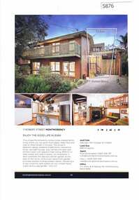
Advertising Leaflet, Buckingham and Company Estate Agents, 11 Robert Street Montmorency, 2018_11
Advertising for 11 Robert Street Montmorency, 3 bedroom house, sold November 2018 for $767,000. Previous sales: August 1999 for $198,500 and May 1979 $16,500.Colour page from real estate magazine. robert street montmorency -
 Whitehorse Historical Society Inc.
Document, Walker Estate: special character area, 1/05/1999 12:00:00 AM
Urban character study of the Walker EstateUrban character study of the Walker EstateUrban character study of the Walker Estatemitcham road, mitcham, walker estate, agra street, mitcham, benares street, mitcham, calcutta street, mitcham, delhi street. mitcham, meerut street, mitcham, simla street, mitcham -
Whitehorse Historical Society Inc.
Map, Township of Norwich, ca 1850
Plan of the Township of Norwich being subdivision of Section III, Parish of Nunawading, County of Bourke, consisting of suburban farms, vineyard sites and town lots, for sale by auction by W. Casey & Co. [c. 1850]. Original in Vale Maps Collection, La Trobe Library.norwich village, vermont, parish of nunawading, vermont south, maps -
 Ringwood and District Historical Society
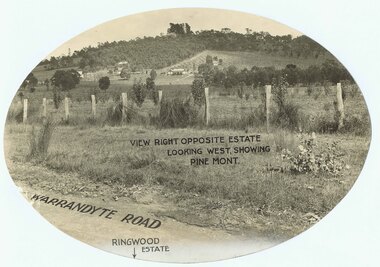
Photograph, Promotional photograph - View opposite Ringwood Estate, Warrandyte Road, looking west towards Pine Mont. (no date)
Printing on photograph reads, "View right opposite estate looking west, showing Pine Mont. Warrandyte Road". Catalogue card reads, "Pinemont Estate (Loughnan's Hill). Right opposite estate looking west." -
 Kew Historical Society Inc
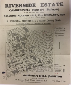
Plan - Subdivision Plan, Riverside Estate, Camberwell North (Balwyn), 1938, 1939
This subdivision known as the Riverside Estate wa sone of the largest and most significant in Balwyn's history.Subdivision Plan for 41 lots within the wider Riverside Estate in Camberwell North, now Balwyn, in February 1938. The auction featured lots in Burke Road, The Boulevard, Mt View Road, Wattle Avenue, Kyora Parade, Cascade Street, Riverside Avenue, Walbundry Avenue, Inverness Way, Bulleen Road and Doncaster Road.Allotments for sale are shaded grey on the map. Certain lots have an H in a circle. These are presumably where houses had already been constructed.subdivision plans - balwyn (vic), riverside estate - balwyn (vic) -
 Greensborough Historical Society
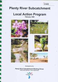
Book, Plenty River Subcatchment: Local Action Plan / Plenty River Subcatchment Working Group, 1999_02
Plenty River Subcatchment Implementation Program was developed to provide information on local catchment management issues and actions to address these issues.44 page book in spiral binding. Col. illus and maps. 2 copies.plenty river, yarra river -
 Eltham District Historical Society Inc
Photograph, Construction of new bridge over the Plenty River, Main Road, Lower Plenty, c.Aug. 1966
Construction of the Main Road bridge over the Plenty River. Includes structural members, construction personnel, vehicles and a Clarke mobile crane.Local significanceBlack and white printlower plenty, main road, plenty river, bridge, bridge construction, civil engineering, cranes, mobile cranes -
 Kiewa Valley Historical Society
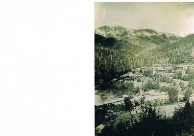
Photograph Bogong Township, Bogong Township Circa 1940s right side view, circa 1950
The Bogong Township (circa 1930s) was constructed by The State Electricity Commission of Victoria as a base camp for construction workers under the Kiewa Hydroelectric Scheme starting in 1938. The Scheme employed 4000 men during its construction phase. A small number were first housed at Bogong Village and when required the Mount Beauty Township was established(1949). Construction at the dams and Power Stations was interrupted during World War II. June 1951 started construction at full pace. The Bogong Township was developed firstly as an accommodation centre (base camp) for construction workers employed under the Kiewa Hydroelectric Scheme. Due to the influx of European workers into the Township the beautification of the immediate surrounds(gardens etc.) had a distinct European flavour. This environment has been very beneficial for tourism in later years. Strict environmental control has not allowed for any extensive redevelopment in tourist accommodation and basically restricted it to the accommodation initially built for the construction workers. Activities such a bike riding, snow skiing, restricted horse riding and bush walking on the Alpine plains and mountains are now a viable part of the Kiewa Valley Tourist Industry.Scanned copy of original black and white photo. Paper manufacturer is Kodak. Paper is Kodak XtraLife II.On reverse side "Kodak ExtaLife II paper"bogong village, bogong township, sec alpine constructions, victorian alpine tourism, winter sports. -
Clunes Museum
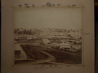
Photograph - PHOTOGRAPHS, VIEW IN TOWNSHIP, CLUNES, SOUTH EAST
Five reproduced black and white images of Clunes and surrounds; Camp Parade, Clunes South West View in Township, Clunes South East Port Phillip and Colonial Goldmining Company Victoria Quartz Mining Company Registered, Clunes Criterion Quartz Mining Company Registered Clunes clunes township, clunes mines -
 Lakes Entrance Historical Society
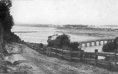
Postcard - Cunninghame township, Lakes Entrance Victoria c1905, 1905c
Also Black and white copy 12.5x20.5 Good condition P01146.1Black and white postcard of Cunninghame township, mud flats, North Arm Bridge, wooden bridge to mud island in North Arm, post and rail fence, beside main road. Road appears to have a sand surface. Bicycle leaning against fence. Lakes Entrance Victoriabridges, fences, topography, roads and streets -
 Clunes Museum
Photograph, BEAUCHAMP PHOTOGRAPHY, CLUNES TOWNSHIP, CIRCA 1870
PHOTOGRAPH OF CLUNES TOWNSHIP LOOKING WEST TAKEN FROM MRS.GREENWOODS HOME IN GEORGE STREET, CLUNES. BUILDINGS SHOWN INCLUDE JAMES MOLONEY AND CRITERION HOUSE. .1 SEPIA PHOTOGRAPH MOUNTED WITH POINTS OF INTEREST NOTED AROUND THE BORDER OF THE PHOTOGRAPH .2 LARGER SEPIA PHOTOGRAPH MOUNTEDFROM GEORGE STREET, LOOKING WESTlocal history, photography, clunes township -
 Kew Historical Society Inc
Plan - Subdivision Plan, Rimington Nursery Estate, 1949
Pru Sanderson, in her groundbreaking ‘City of Kew Urban Conservation Study : Volume 2 - Development History’ (1988), summarised the periods of urban development and subdivisions of land in Kew. The periods that she identified included 1845-1880, 1880-1893, 1893-1921, 1921-1933, 1933-1943, and Post-War Development. These periods were selected as they represented periods of rapid growth or decline in urban development. An obvious starting point for Sanderson’s groupings involved population growth and the associated economic cycles. These cycles also highlighted urban expansion onto land that was predominantly rural, although in other cases it represented the decline and breakup of large estates. A number of the plans in the Kew Historical Society’s collection can also be found in other collections, such as those of the State Library of Victoria and the Boroondara Library Service. A number are however unique to the collection.The Kew Historical Society collection includes almost 100 subdivision plans pertaining to suburbs of the City of Melbourne. Most of these are of Kew, Kew East or Studley Park, although a smaller number are plans of Camberwell, Deepdene, Balwyn and Hawthorn. It is believed that the majority of the plans were gifted to the Society by persons connected with the real estate firm - J. R. Mathers and McMillan, 136 Cotham Road, Kew. The Plans in the collection are rarely in pristine form, being working plans on which the agent would write notes and record lots sold and the prices of these. The subdivision plans are historically significant examples of the growth of urban Melbourne from the beginning of the 20th Century up until the 1980s. A number of the plans are double-sided and often include a photograph on the reverse. A number of the latter are by noted photographers such as J.E. Barnes.The house lots in the Rimington Nursery Estate were advertised for sale on Saturday 22nd October 1949. The nine lots in the sale were in Stoke Avenue and Burke Road. Mathers & McMillan of 136 Cotham Road, Kew, offered the lots for sale. [The final sale of lots within the Rimington Nursery Estate occurred as late as 1958.]subdivision plans - kew, rimington nursery estate, monist victor road - kew (vic.) -
 Kew Historical Society Inc
Plan - Subdivision Plan, Mount Ida Estate, 1925
The Kew Historical Society collection includes almost 100 subdivision plans pertaining to suburbs of the City of Melbourne. Most of these are of Kew, Kew East or Studley Park, although a smaller number are plans of Camberwell, Deepdene, Balwyn and Hawthorn. It is believed that the majority of the plans were gifted to the Society by persons connected with the real estate firm - J. R. Mathers and McMillan, 136 Cotham Road, Kew. The Plans in the collection are rarely in pristine form, being working plans on which the agent would write notes and record lots sold and the prices of these. The subdivision plans are historically significant examples of the growth of urban Melbourne from the beginning of the 20th Century up until the 1980s. A number of the plans are double-sided and often include a photograph on the reverse. A number of the latter are by noted photographers such as J.E. Barnes.The Mount Ida Estate was a subdivision of fifty-two residential allotments bordering Tooronga Road, Leura Grove, Constance Street, and Mount Ida Avenue in Hawthorn East. The report of the sale of the Estate in The Argus (21 September) claimed that over 1,000 people attended the auction and that all allotments were sold on the day. On the other side of Constance Street, the plan identifies the ‘Eastern Recreation Reserve’ (now Anderson Park).subdivision plans - hawthorn -
Whitehorse Historical Society Inc.
Document, Fulton Park Estate, 1970s
Real estate brochure for the sale of 49 blocks at Fulton Park Estate Blackburn South.Real estate brochure for the sale of 49 blocks at Fulton Park Estate Blackburn South. Agents: E Flintoff & Sons and K F LangReal estate brochure for the sale of 49 blocks at Fulton Park Estate Blackburn South. fulton road, blackburn south, freda court, blackburn south, lucia street, blackburn south, mira street, blackburn south, lana street, blackburn south, residential development, fulton park estate -
 City of Kingston
Pamphlet - Colour, Ozone Hill Estate, Cheltenham, 1923
Sales plan for land in the suburb of Cheltenham, along both sides of Victori Avenue, off Weatherall Road.The developing urban area of Cheltenham within the City of Kingston. This land sale pamphlet illustrates the subdivision of land within the municipality and the changing demographic of the district as new houses are constructed.Colour pamphlet advertising for sale the Ozone Hill Estate, Cheltenham. Incorporates a map of the estate on either side of Victor Avenue, off Weatherall Road. Handwritten in blue ink on the subdivision map: 'Sold' is written on subdivisions 1-4, 8, 11, 13, 16-26, 28, 29, 33, 39-41 Handwritten in blue ink on the subdivision map: 'House being erected' is written on subdivisions 22 and 33. Handwrittten in grey pencil adjacent to subdivisions 21 and 22: Tennis / Courts / being / constructed / here Handwritten in grey pencil at bottom of page: Revised to 30/1/24 Handwritten in grey pencil on subdivision map: assumed land sale price is recorded on subdivisions 5-9, 9-10, 12, 14-15, 27, 30-32, 34-38. land sales, cheltenham, estate -
 City of Kingston
Pamphlet - Colour, Stillwell and Co, Cheltenham Charman Estate Realising Auction, 1921
Sales plan for land in the suburb of Cheltenham, along Charman Road and Weatherall Street.The developing urban area of Cheltenham within the City of Kingston. This land sale pamphlet illustrates the subdivision of land within the municipality and the changing demographic of the district as new houses are constructed.Colour pamphlet advertising realising auction of the Charman Estate, Cheltenham. Incorporates a map of the estate, showing subdivisions along Charman Road and Weatherall Street.land sales, cheltenham, estate -
 Eltham District Historical Society Inc
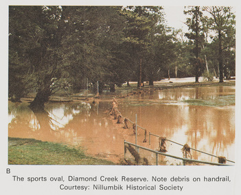
Work on paper (Sub-Item) - Photograph, The Sports Oval, Diamond Creek Reserve, Diamond Creek Township, 8 April 1977
Colour photograph. Note debris on the rail fencing around the oval. The Diamond Creek in flood at Diamond Creek township, 8 April 1977 Nillumbik Historical Society collectionflood, diamond creek, flooding, oval, nillumbik historical society, rail -
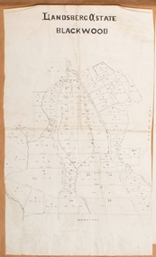 Bacchus Marsh & District Historical Society
Map, Landsberg Estate Blackwood
The date this map was created has not been identified. It was possibly created at the time the Landsberg Estate near Blackwood was subdivided and sold into smaller lots in December 1886.Single page map showing land allotments which made up the Landsberg Estate near Blackwood. Scale 20 chains to 1 inch. The map is pasted into a bound volume containing 76 maps or plans in total. High resolution digital image stored on BMDHS computer network. bacchus marsh victoria maps, landsberg estate blackwood -
Ringwood and District Historical Society
Envelope, Sales, Auctions and Subdivisions - Pinemont Estate, Ringwood 1931
Sales, Auctions and Subdivisions - Pinemont Estate 1931 -
Stawell Historical Society Inc
Map, The Litho Co Ballarat, Glyntowyn Estate Campbells Bridge 1909, 1909
Shows Hoestead CC McCulloch ESQPaper map / Poster Advertising Subdivision of EstateMitchell Bros & White. 5003 Acres The Litho Co Ballarat Black Printing with Red Coloured Sectionsfarming -
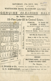 Whitehorse Historical Society Inc.
Document, Central Estate, 1935
Clearing saleClearing sale - 22 lots in Central Estate.Clearing sale g. woods & co. auctioneer, g. c. karnaghan estate agent, whitehorse road, blackburn, williams road, harold street, o'hara street -
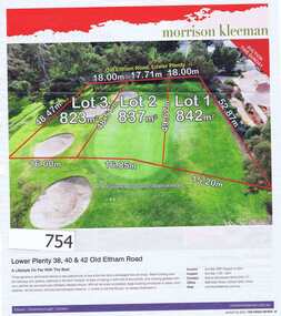 Greensborough Historical Society
Advertisement, Fairfax Media, Lower Plenty 38, 40 & 42 Old Eltham Road, 22/08/2012
This advert appear in the Weekly Review on 22/08/2012.It features the sale of 38, 40 & 42 Old Eltham Rd, Lower Plenty in 2012. Land borders Heidelberg Golf Club.A 1 page multi coloured Real Estate advertisement.Nillower plenty, morrison kleeman, old eltham road -
 Kew Historical Society Inc
Plan - Subdivision Plan, Harvest Home Estate, 1919
Pru Sanderson, in her groundbreaking ‘City of Kew Urban Conservation Study : Volume 2 - Development History’ (1988), summarised the periods of urban development and subdivisions of land in Kew. The periods that she identified included 1845-1880, 1880-1893, 1893-1921, 1921-1933, 1933-1943, and Post-War Development. These periods were selected as they represented periods of rapid growth or decline in urban development. An obvious starting point for Sanderson’s groupings involved population growth and the associated economic cycles. These cycles also highlighted urban expansion onto land that was predominantly rural, although in other cases it represented the decline and breakup of large estates. A number of the plans in the Kew Historical Society’s collection can also be found in other collections, such as those of the State Library of Victoria and the Boroondara Library Service. A number are however unique to the collection.The Kew Historical Society collection includes almost 100 subdivision plans pertaining to suburbs of the City of Melbourne. Most of these are of Kew, Kew East or Studley Park, although a smaller number are plans of Camberwell, Deepdene, Balwyn and Hawthorn. It is believed that the majority of the plans were gifted to the Society by persons connected with the real estate firm - J. R. Mathers and McMillan, 136 Cotham Road, Kew. The Plans in the collection are rarely in pristine form, being working plans on which the agent would write notes and record lots sold and the prices of these. The subdivision plans are historically significant examples of the growth of urban Melbourne from the beginning of the 20th Century up until the 1980s. A number of the plans are double-sided and often include a photograph on the reverse. A number of the latter are by noted photographers such as J.E. Barnes.The ‘Harvest Home Estate’ was advertised as being a subdivision in East Kew. Now, Campbell and Owen Streets on which the allotments were located are classed as being in Kew. The Estate included 11 residential allotments abutting the Outer Circle Railway line [at the end of Owen Street]. Understandably, the vendors focused on the availability of transport by tram, noting that the Estate was near the High Street tram terminus at the Harp of Erin. A small note on the subdivision advises that the Cotham Road tram was only 3 minutes away. The location – ‘The most elevated position in lovely Kew’ – was also promoted as an advantage.subdivision plans - east kew, harvest home estate -
 City of Kingston
Pamphlet - Black and white, J. F. Brady, The Hill Estate, Highett, c. 1905
Sales plan for land in the suburb of Highett, bounded by Sandford Street, Turner Street and Point Nepean RoadThe developing urban area of Highett within the City of Kingston. This land sale pamphlet illustrates the subdivision of land within the municipality and the changing demographic of the district as new houses are constructed close to infrastructure.Black and white pamphlet advertising for sale the Hill Estate, Highett. Incorporates a map of the estate bordered by Sandford Street, Turner Street and Point Nepean Road.Handwritten in grey pencil on reverse: The Hillland sales, highett, estate -
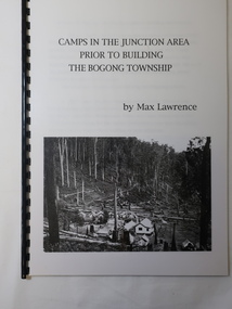 Kiewa Valley Historical Society
Booklet - Camps at Bogong Junction. 1930s, Camps in the Junction Area Prior to Building the Bogong Township by Max Lawrence
During the construction of the Kiewa Hydro Electric Scheme at Bogong Junction camps of tents were built from 1935. These were replaced by houses for the workers in 1940 when the Bogong township was built.The SECV constructed the Bogong township to house workers on the Kiewa Hydro Electric SchemeA plastic Folder with a black spiral spine and black back cover. 3 pages typed on one side naming and describing the camps at Bogong Junction in the 1930s.miners camp, staff camp, reservoir camp, bogong township, lewis construction camp, albion quarry camp -
![Map, Late the Property of Robert Lawson Esq. [Landsberg Estate Blackwood]](/media/collectors/5e461d8021ea67224c82f2a1/items/67763722eb6d2cbd24dff14f/item-media/677637b7eb6d2cbd24dff29d/item-fit-380x285.jpg) Bacchus Marsh & District Historical Society
Bacchus Marsh & District Historical SocietyMap, Late the Property of Robert Lawson Esq. [Landsberg Estate Blackwood]
The date this map was created has not been identified. It was possibly created at the time the Landsberg Estate near Blackwood was subdivided and sold into smaller lots in December 1886. This land once belonged to Robert Lawson who died in 1869. Lawson was a well known school teacher who founded Scotch College in Melbourne before setting up a school near Blackwood. This map is similar to another map in the BMDHS collection titled 'Landsberg Estate Blackwood' Victorian Collections record 459 and was possibly produced at the same time.Single page map showing land allotments which made up the Landsberg Estate near Blackwood. Scale 20 chains to 1 inch. The map is pasted into a bound volume containing 76 maps or plans in total. High resolution digital image stored on BMDHS computer network. At the top of the map: 'Late the Property of Robert Lawson Esq.'bacchus marsh victoria maps, landsberg estate blackwood -
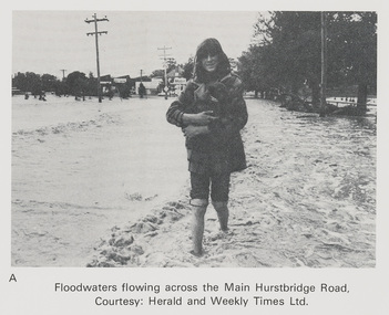 Eltham District Historical Society Inc
Work on paper (Sub-Item) - Photograph, Floodwaters flowing across Main Hurstbridge Road, Diamond Creek Township, 8 April 1977
Black and white photograph of young woman walking through floodwaters, possibly carrying an animal. The Diamond Creek in flood at Diamond Creek township, 8 April 1977 Herald and Weekly Times collectionflood, diamond creek, flooding, herald and weekly times, rescue -
 City of Kingston
Pamphlet - Black and white, Stott & Burke, Highland Estate Bentleigh, c.1915
Sales plan for land in the suburb of Bentleigh, along Collins and Ross Streets, bounded by Jasper Road.The developing urban area of Bentleigh within the City of Kingston. This land sale pamphlet illustrates the subdivision of land within the municipality and the changing demographic of the district as new houses are constructed.Black and white pamphlet advertising for private sale the Highland Estate, Bentleigh. Incorporates a map of the estate between Collins St and Ross St, bordered by Japser Road. Handwritten in grey pencil on map: additional subdivisions numbered 15-19 drawn along Ross St Handwritten in grey pencil on map: indecipherable annotations to subdivisions 1, 3 and 14land sales, bentleigh, estate -
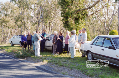 Eltham District Historical Society Inc
Photograph, Bonds Road, Lower Plenty, Autumn Excursion to Lower Plenty area, 18 April 1998, 18/04/1998
Eltham Heritage Study Tour; Russell Yeoman and society members on Bonds Road opposite Rosehill 1856(?) property. Includes people from the Friends of the Lower Plenty.Roll of 35mm colour negative film, 2 stripsKodak Gold 200-6activities, anne paul, blanche shallard, bonds road, lower plenty, opal smith, rosehill, sue law, doug orford, russell yeoman -
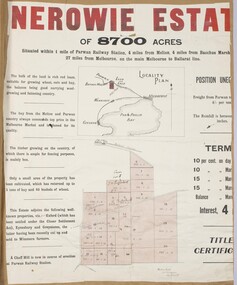 Bacchus Marsh & District Historical Society
Map, Nerowie Estate Land Sale 1910
The Nerowie Estate was a large rural property of 8,700 acres (3520 hectares) near the locality of Parwan only a few kilometers east of Bacchus Marsh. It had once formed a large part of the land owned by the pioneering Staughton family.A single page paper map showing the land offered for sale from the Nerowie Estate at Parwan near Bacchus Marsh in 1910. The map is pasted into a bound volume containing 76 maps or plans in total. High resolution digital image stored on BMDHS computer network. nerowie estate parwan, land sales parwan, land sales bacchus marsh, staughton family bacchus marsh