Showing 645 items
matching railway road bridge
-
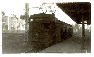
 Ballarat Tramway Museum
Photograph - Black and White photograph - laminated, John Phillips, 1968
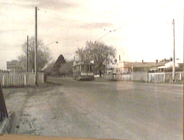
Black and white photo of No. 31, inward bound from Victoria St. crossing the Buniyong railway overbridge. Meaghers Hotel in background and ad for Eureka Caravan park. No cars on the road. 'Smash Imperialism' graffiti on bridge beam. Tram fitted with lights, small number over headlight, and long Twin Lakes sign under headlight. Image on data base file, made from digital photo of photo 22/6/02.trams, tramways, ballarat, victoria st., tram 31 -
 Kew Historical Society Inc
Plan - Subdivision Plan, H C Crouch, Old Golf Links Estate, 1930s
The land in North Kew between the Outer Circle Railway and the River Yarra was released in sections. This release included 80 lots. Most of this area was released during the Depression years in the early 1930s.Subdivision plans are historically important documents used as evidence of the growth of suburbs in Australia. They frequently provide information about when the land was sold on which a built structure was subsequently constructed as well as evidence relating to surveyors and real estate and financial agents. The numerous subdivision plans in the Kew Historical Society's collection represent working documents, ranging from the initial sketches made in planning a subdivision to printed plans on which auctioneers or agents listed the prices for which individual lots were sold. In a number of cases, the reverse of a subdivision plan in the collection includes a photograph of a house that was also for sale by the agent. These photographs provide significant heritage information relating house design and decoration, fencing and household gardens.One part of a massive subdivision of the Old Golf Links Estate in North Kew of 80 allotments bordering Sutherland Avenue, Ramsay Avenue, Belford Road, Beresford Street and Coleman Avenue. Inset on the plan at the top left, the route of the Outer Circle Railway is clearly marked. The Kew Golf Links is identified in its current location. The land on which Greenacres Golf Club was to be constructed is at this time marked as ‘Recreation Ground’. The ‘new bridge’ over the Yarra at Burke Road is also marked on the inset map. The Plan identifies the surveyor (sic) H.C. Crouch BCE MVIS, 443 Little Collins St., Melbourne. The date of the subdivision auction sale in identified as Saturday September 25th at three o'clock.Annotations: "E" top left. "Golf Links" top right. Lots 73-76 ticked and listed as "6" poundssubdivisions -- kew (vic.), old golf links estate -
 Kew Historical Society Inc
Photograph - Looking towards Kew from Strathalbyn Street and High Street, c.1916
An electrified tram route from Melbourne along High Street replaced an original Horse Tram that terminated at the Kew Cemetery. This new tram only reached the bridge over the Outer Circle railway at the Harp Junction. The line was later extended to North Balwyn.Black and white print positive showing the view west along High Street, Kew (formerly Bulleen Road). In the centre distance is the Boroondara General (Kew) Cemetery. In the foreground, the road crosses the Outer Circle railway. The photograph reflects the level of urbanisation in Kew during the First World War. "Looking towards Kew from Strathalbyn St / High St corner, about 1916. Courtesy Mrs E Bennett, Kew East / Property of Miss Foley"trams -- kew, trams -- kew east, mmtb, m&mtb, tramways, harp junction -
 Kew Historical Society Inc
Photograph - The last train at Barker Station, 1952
The Kew railway was opened in 1887, and diverged from the main (Box Hill–Lilydale) line about half-way between Hawthorn and Glenferrie. From the point of divergence the line was slightly less than one mile long, and it had only one intermediate station — Barker. There were four road over-bridges and two level crossings, including one over the busy Barkers Road. The line supported a passenger and goods service, and was electrified in December 1922, at the same time as the main line to Box Hill. There were a number of peak hour services which ran from Flinders Street station (Melbourne) to Kew, but in 1938 all but one of these were diverted to the Ashburton line, where traffic was growing. This had an adverse effect on Kew traffic, as passengers from Kew needed to cross over a footbridge at Hawthorn to change trains, and the main line trains were usually already crowded by the time they reached Hawthorn. At about the same time the off-peak trains were replaced by road buses. In 1952 all passenger trains were withdrawn, but the road bus service continued for many years. Goods trains were finally withdrawn in 1957, and the railway was dismantled in 1958-59. (Source: Frank Stamford, 'The Hawthorn - Kew Railway')Small black and white snapshot of the last passenger train at Barker Railway Station in 1952. The photograph, one of 12, is part of a larger album of newspaper clippings, timetables, tickets and photos relating to the Kew Railway Line, taken and compiled by Lachlan Richardson, while a resident of Kew. The album dates from the 1950s. The album is part of a larger subject file on the Kew Line, compiled over time by members of the Kew Historical Society."Last train at Barker Station / 1 August 1952"kew railway line, transport -- railways -- kew (vic.), barker railway station, kew branch line -
 Kew Historical Society Inc
Photograph - Barker Station, August 1952
The Kew railway was opened in 1887, and diverged from the main (Box Hill–Lilydale) line about half-way between Hawthorn and Glenferrie. From the point of divergence the line was slightly less than one mile long, and it had only one intermediate station — Barker. There were four road over-bridges and two level crossings, including one over the busy Barkers Road. The line supported a passenger and goods service, and was electrified in December 1922, at the same time as the main line to Box Hill. There were a number of peak hour services which ran from Flinders Street station (Melbourne) to Kew, but in 1938 all but one of these were diverted to the Ashburton line, where traffic was growing. This had an adverse effect on Kew traffic, as passengers from Kew needed to cross over a footbridge at Hawthorn to change trains, and the main line trains were usually already crowded by the time they reached Hawthorn. At about the same time the off-peak trains were replaced by road buses. In 1952 all passenger trains were withdrawn, but the road bus service continued for many years. Goods trains were finally withdrawn in 1957, and the railway was dismantled in 1958-59. (Source: Frank Stamford, 'The Hawthorn - Kew Railway')Small black and white snapshot of the last passenger train at Barker Railway Station in 1952. The photograph, one of 12, is part of a larger album of newspaper clippings, timetables, tickets and photos relating to the Kew Railway Line, taken and compiled by Lachlan Richardson, while a resident of Kew. The album dates from the 1950s. The album is part of a larger subject file on the Kew Line, compiled over time by members of the Kew Historical Society."Barker Station / August 1952"kew railway line, transport -- railways -- kew (vic.), barker railway station, kew branch line -
 Kew Historical Society Inc
Photograph - Kew Railway Station: Denmark Street entrance, 1952
The Kew railway was opened in 1887, and diverged from the main (Box Hill–Lilydale) line about half-way between Hawthorn and Glenferrie. From the point of divergence the line was slightly less than one mile long, and it had only one intermediate station — Barker. There were four road over-bridges and two level crossings, including one over the busy Barkers Road. The line supported a passenger and goods service, and was electrified in December 1922, at the same time as the main line to Box Hill. There were a number of peak hour services which ran from Flinders Street station (Melbourne) to Kew, but in 1938 all but one of these were diverted to the Ashburton line, where traffic was growing. This had an adverse effect on Kew traffic, as passengers from Kew needed to cross over a footbridge at Hawthorn to change trains, and the main line trains were usually already crowded by the time they reached Hawthorn. At about the same time the off-peak trains were replaced by road buses. In 1952 all passenger trains were withdrawn, but the road bus service continued for many years. Goods trains were finally withdrawn in 1957, and the railway was dismantled in 1958-59. (Source: Frank Stamford, 'The Hawthorn - Kew Railway')Small black and white snapshot of the entrance to Kew Station from Denmark Street in 1952. The photograph, one of 12, is part of a larger album of newspaper clippings, timetables, tickets and photos relating to the Kew Railway Line, taken and compiled by Lachlan Richardson, while a resident of Kew. The album dates from the 1950s. The album is part of a larger subject file on the Kew Line, compiled over time by members of the Kew Historical Society.kew railway line, transport -- railways -- kew (vic.), kew branch line, kew railway station -
 Kew Historical Society Inc
Photograph - Kew Station 22/4/51, F3
The Kew railway was opened in 1887, and diverged from the main (Box Hill–Lilydale) line about half-way between Hawthorn and Glenferrie. From the point of divergence the line was slightly less than one mile long, and it had only one intermediate station — Barker. There were four road over-bridges and two level crossings, including one over the busy Barkers Road. The line supported a passenger and goods service, and was electrified in December 1922, at the same time as the main line to Box Hill. There were a number of peak hour services which ran from Flinders Street station (Melbourne) to Kew, but in 1938 all but one of these were diverted to the Ashburton line, where traffic was growing. This had an adverse effect on Kew traffic, as passengers from Kew needed to cross over a footbridge at Hawthorn to change trains, and the main line trains were usually already crowded by the time they reached Hawthorn. At about the same time the off-peak trains were replaced by road buses. In 1952 all passenger trains were withdrawn, but the road bus service continued for many years. Goods trains were finally withdrawn in 1957, and the railway was dismantled in 1958-59. (Source: Frank Stamford, 'The Hawthorn - Kew Railway')Small black and white snapshot of Kew Railway Station, looking south to Barker Station. The photograph, one of 12, is part of a larger album of newspaper clippings, timetables, tickets and photos relating to the Kew Railway Line, taken and compiled by Lachlan Richardson, while a resident of Kew. The album dates from the 1950s. The album is part of a larger subject file on the Kew Line, compiled over time by members of the Kew Historical Society.kew railway line, transport -- railways -- kew (vic.), kew branch line, kew railway station -
 Kew Historical Society Inc
Photograph - Kew Branch Line : The Hawthorn Grove crossing, August 1952
The Kew railway was opened in 1887, and diverged from the main (Box Hill–Lilydale) line about half-way between Hawthorn and Glenferrie. From the point of divergence the line was slightly less than one mile long, and it had only one intermediate station — Barker. There were four road over-bridges and two level crossings, including one over the busy Barkers Road. The line supported a passenger and goods service, and was electrified in December 1922, at the same time as the main line to Box Hill. There were a number of peak hour services which ran from Flinders Street station (Melbourne) to Kew, but in 1938 all but one of these were diverted to the Ashburton line, where traffic was growing. This had an adverse effect on Kew traffic, as passengers from Kew needed to cross over a footbridge at Hawthorn to change trains, and the main line trains were usually already crowded by the time they reached Hawthorn. At about the same time the off-peak trains were replaced by road buses. In 1952 all passenger trains were withdrawn, but the road bus service continued for many years. Goods trains were finally withdrawn in 1957, and the railway was dismantled in 1958-59. (Source: Frank Stamford, 'The Hawthorn - Kew Railway')Small black and white snapshot of the Hawthorn Grove crossing, August 1952. The photograph, one of 12, is part of a larger album of newspaper clippings, timetables, tickets and photos relating to the Kew Railway Line, taken and compiled by Lachlan Richardson, while a resident of Kew. The album dates from the 1950s. The album is part of a larger subject file on the Kew Line, compiled over time by members of the Kew Historical Society.kew railway line, transport -- railways -- kew (vic.), kew branch line, hawthorn grove -- hawthorn (vic.), railway crossings -
 Kew Historical Society Inc
Photograph - Seven Carriage Train at Barker Station
The Kew railway was opened in 1887, and diverged from the main (Box Hill–Lilydale) line about half-way between Hawthorn and Glenferrie. From the point of divergence the line was slightly less than one mile long, and it had only one intermediate station — Barker. There were four road over-bridges and two level crossings, including one over the busy Barkers Road. The line supported a passenger and goods service, and was electrified in December 1922, at the same time as the main line to Box Hill. There were a number of peak hour services which ran from Flinders Street station (Melbourne) to Kew, but in 1938 all but one of these were diverted to the Ashburton line, where traffic was growing. This had an adverse effect on Kew traffic, as passengers from Kew needed to cross over a footbridge at Hawthorn to change trains, and the main line trains were usually already crowded by the time they reached Hawthorn. At about the same time the off-peak trains were replaced by road buses. In 1952 all passenger trains were withdrawn, but the road bus service continued for many years. Goods trains were finally withdrawn in 1957, and the railway was dismantled in 1958-59. (Source: Frank Stamford, 'The Hawthorn - Kew Railway')Small black and white snapshot of a seven carriage train approaching Barker Railway Station. The photograph, one of 12, is part of a larger album of newspaper clippings, timetables, tickets and photos relating to the Kew Railway Line, taken and compiled by Lachlan Richardson, while a resident of Kew. The album dates from the 1950s. The album is part of a larger subject file on the Kew Line, compiled over time by members of the Kew Historical Society."Seven Carriage Train at Barker Station"kew railway line, transport -- railways -- kew (vic.), barker railway station, kew branch line -
 Kew Historical Society Inc
Photograph - Farewell to 'Our Lady of Fatima'. Xavier College 22/4/51
The Kew railway was opened in 1887, and diverged from the main (Box Hill–Lilydale) line about half-way between Hawthorn and Glenferrie. From the point of divergence the line was slightly less than one mile long, and it had only one intermediate station — Barker. There were four road over-bridges and two level crossings, including one over the busy Barkers Road. The line supported a passenger and goods service, and was electrified in December 1922, at the same time as the main line to Box Hill. There were a number of peak hour services which ran from Flinders Street station (Melbourne) to Kew, but in 1938 all but one of these were diverted to the Ashburton line, where traffic was growing. This had an adverse effect on Kew traffic, as passengers from Kew needed to cross over a footbridge at Hawthorn to change trains, and the main line trains were usually already crowded by the time they reached Hawthorn. At about the same time the off-peak trains were replaced by road buses. In 1952 all passenger trains were withdrawn, but the road bus service continued for many years. Goods trains were finally withdrawn in 1957, and the railway was dismantled in 1958-59. (Source: Frank Stamford, 'The Hawthorn - Kew Railway')Small black and white snapshot of a train leaving Kew Station with the Xavier Chapel on the hill in the background, hence the ironic title provided by the photographer. The photograph, one of 12, is part of a larger album of newspaper clippings, timetables, tickets and photos relating to the Kew Railway Line, taken and compiled by Lachlan Richardson, while a resident of Kew. The album dates from the 1950s. The album is part of a larger subject file on the Kew Line, compiled over time by members of the Kew Historical Society."Farewell to 'Our Lady of Fatima'. Xavier College 22/4/51"kew railway line, transport -- railways -- kew (vic.), kew branch line, xavier college, kew railway station -
 Kew Historical Society Inc
Photograph - Kew Branch Line: Looking along cutting towards Barker Station 22/4/51
The Kew railway was opened in 1887, and diverged from the main (Box Hill–Lilydale) line about half-way between Hawthorn and Glenferrie. From the point of divergence the line was slightly less than one mile long, and it had only one intermediate station — Barker. There were four road over-bridges and two level crossings, including one over the busy Barkers Road. The line supported a passenger and goods service, and was electrified in December 1922, at the same time as the main line to Box Hill. There were a number of peak hour services which ran from Flinders Street station (Melbourne) to Kew, but in 1938 all but one of these were diverted to the Ashburton line, where traffic was growing. This had an adverse effect on Kew traffic, as passengers from Kew needed to cross over a footbridge at Hawthorn to change trains, and the main line trains were usually already crowded by the time they reached Hawthorn. At about the same time the off-peak trains were replaced by road buses. In 1952 all passenger trains were withdrawn, but the road bus service continued for many years. Goods trains were finally withdrawn in 1957, and the railway was dismantled in 1958-59. (Source: Frank Stamford, 'The Hawthorn - Kew Railway')Small black and white snapshot looking along cutting towards Barker Station 22/4/51. The photograph, one of 12, is part of a larger album of newspaper clippings, timetables, tickets and photos relating to the Kew Railway Line, taken and compiled by Lachlan Richardson, while a resident of Kew. The album dates from the 1950s. The album is part of a larger subject file on the Kew Line, compiled over time by members of the Kew Historical Society."Looking along cutting towards Barker Station 22/4/51"kew railway line, transport -- railways -- kew (vic.), barker railway station, kew branch line -
 Kew Historical Society Inc
Photograph - The last train at Kew Station, August 1952
The Kew railway was opened in 1887, and diverged from the main (Box Hill–Lilydale) line about half-way between Hawthorn and Glenferrie. From the point of divergence the line was slightly less than one mile long, and it had only one intermediate station — Barker. There were four road over-bridges and two level crossings, including one over the busy Barkers Road. The line supported a passenger and goods service, and was electrified in December 1922, at the same time as the main line to Box Hill. There were a number of peak hour services which ran from Flinders Street station (Melbourne) to Kew, but in 1938 all but one of these were diverted to the Ashburton line, where traffic was growing. This had an adverse effect on Kew traffic, as passengers from Kew needed to cross over a footbridge at Hawthorn to change trains, and the main line trains were usually already crowded by the time they reached Hawthorn. At about the same time the off-peak trains were replaced by road buses. In 1952 all passenger trains were withdrawn, but the road bus service continued for many years. Goods trains were finally withdrawn in 1957, and the railway was dismantled in 1958-59. (Source: Frank Stamford, 'The Hawthorn - Kew Railway')Small black and white snapshot of the last passenger train at Kew Railway Station in 1952. The photograph, one of 12, is part of a larger album of newspaper clippings, timetables, tickets and photos relating to the Kew Railway Line, taken and compiled by Lachlan Richardson, while a resident of Kew. The album dates from the 1950s. The album is part of a larger subject file on the Kew Line, compiled over time by members of the Kew Historical Society."The last train at Kew Station, August 1952"kew railway line, transport -- railways -- kew (vic.), kew branch line, kew railway station -
 Kew Historical Society Inc
Photograph - Kew Branch Line: Weeds at Kew Station 14/51
The Kew railway was opened in 1887, and diverged from the main (Box Hill–Lilydale) line about half-way between Hawthorn and Glenferrie. From the point of divergence the line was slightly less than one mile long, and it had only one intermediate station — Barker. There were four road over-bridges and two level crossings, including one over the busy Barkers Road. The line supported a passenger and goods service, and was electrified in December 1922, at the same time as the main line to Box Hill. There were a number of peak hour services which ran from Flinders Street station (Melbourne) to Kew, but in 1938 all but one of these were diverted to the Ashburton line, where traffic was growing. This had an adverse effect on Kew traffic, as passengers from Kew needed to cross over a footbridge at Hawthorn to change trains, and the main line trains were usually already crowded by the time they reached Hawthorn. At about the same time the off-peak trains were replaced by road buses. In 1952 all passenger trains were withdrawn, but the road bus service continued for many years. Goods trains were finally withdrawn in 1957, and the railway was dismantled in 1958-59. (Source: Frank Stamford, 'The Hawthorn - Kew Railway')Small black and white snapshot of how the Kew Branch Line was allowed to run down. The photograph, one of 12, is part of a larger album of newspaper clippings, timetables, tickets and photos relating to the Kew Railway Line, taken and compiled by Lachlan Richardson, while a resident of Kew. The album dates from the 1950s. The album is part of a larger subject file on the Kew Line, compiled over time by members of the Kew Historical Society.kew railway line, transport -- railways -- kew (vic.), barker railway station, kew branch line -
 Kew Historical Society Inc
Photograph - Kew Railway Station, May 1950
The Kew railway was opened in 1887, and diverged from the main (Box Hill–Lilydale) line about half-way between Hawthorn and Glenferrie. From the point of divergence the line was slightly less than one mile long, and it had only one intermediate station — Barker. There were four road over-bridges and two level crossings, including one over the busy Barkers Road. The line supported a passenger and goods service, and was electrified in December 1922, at the same time as the main line to Box Hill. There were a number of peak hour services which ran from Flinders Street station (Melbourne) to Kew, but in 1938 all but one of these were diverted to the Ashburton line, where traffic was growing. This had an adverse effect on Kew traffic, as passengers from Kew needed to cross over a footbridge at Hawthorn to change trains, and the main line trains were usually already crowded by the time they reached Hawthorn. At about the same time the off-peak trains were replaced by road buses. In 1952 all passenger trains were withdrawn, but the road bus service continued for many years. Goods trains were finally withdrawn in 1957, and the railway was dismantled in 1958-59. (Source: Frank Stamford, 'The Hawthorn - Kew Railway')Small black and white snapshot of Kew Railway Station inMay 1950. The photograph, one of 12, is part of a larger album of newspaper clippings, timetables, tickets and photos relating to the Kew Railway Line, taken and compiled by Lachlan Richardson, while a resident of Kew. The album dates from the 1950s. The album is part of a larger subject file on the Kew Line, compiled over time by members of the Kew Historical Society."Kew Railway Station, May 1950"kew railway line, transport -- railways -- kew (vic.), kew branch line, kew railway station -
 Kew Historical Society Inc
Photograph - Kew Railway Station, 1951
The Kew railway was opened in 1887, and diverged from the main (Box Hill–Lilydale) line about half-way between Hawthorn and Glenferrie. From the point of divergence the line was slightly less than one mile long, and it had only one intermediate station — Barker. There were four road over-bridges and two level crossings, including one over the busy Barkers Road. The line supported a passenger and goods service, and was electrified in December 1922, at the same time as the main line to Box Hill. There were a number of peak hour services which ran from Flinders Street station (Melbourne) to Kew, but in 1938 all but one of these were diverted to the Ashburton line, where traffic was growing. This had an adverse effect on Kew traffic, as passengers from Kew needed to cross over a footbridge at Hawthorn to change trains, and the main line trains were usually already crowded by the time they reached Hawthorn. At about the same time the off-peak trains were replaced by road buses. In 1952 all passenger trains were withdrawn, but the road bus service continued for many years. Goods trains were finally withdrawn in 1957, and the railway was dismantled in 1958-59. (Source: Frank Stamford, 'The Hawthorn - Kew Railway')Small black and white snapshot of Kew Railway Station in 1950. The photograph, one of 12, is part of a larger album of newspaper clippings, timetables, tickets and photos relating to the Kew Railway Line, taken and compiled by Lachlan Richardson, while a resident of Kew. The album dates from the 1950s. The album is part of a larger subject file on the Kew Line, compiled over time by members of the Kew Historical Society."Kew Station / 14/51 / 22/4/51 F5"kew railway line, transport -- railways -- kew (vic.), kew branch line, kew railway station -
 Kew Historical Society Inc
Journal, Newsletter No.145, December 2023
The Henty Collection [Significance Assessment] / Robert Baker p1. History News - Tributes: Alison Virginia Kemp (1947–2023), Kay Cole JP (1930–2023), Jane Mayo Carolan 1949–2023) ; New Members / p3-4. As it happened 100 years ago [Burke Road Bridge, Kew Primary School, Wilfred Kent Hughes] / David White (ed) / p4. City of Boroondara Triennial Operational Grant 2023–6 / p4. Berma Sellars 'Bib' Stilwell: entrepreneur, businessman, racing driver / Julie King p5-6. The Jellis Affair: make of it what you will [sexual violence, Victorian legal system, Kew Court of Petty Sessions] / Suzanne McWha p7-8. St Andrew's College: Mont Victor Road / Felicity Renowden p9-10. Good Neighbour "Mickey": Memories of the Kew Railway / James Foley p.11. Membership and Donations / p12.Published quarterly since 1977, the newsletters of the Kew Historical Society contain significant research by members exploring relevant aspects of the Victorian and Australian Framework of Historical Themes. Frequently, articles on people, places and artefacts are the only source of information about an aspect of Kew, and Melbourne’s history.non-fictionThe Henty Collection [Significance Assessment] / Robert Baker p1. History News - Tributes: Alison Virginia Kemp (1947–2023), Kay Cole JP (1930–2023), Jane Mayo Carolan 1949–2023) ; New Members / p3-4. As it happened 100 years ago [Burke Road Bridge, Kew Primary School, Wilfred Kent Hughes] / David White (ed) / p4. City of Boroondara Triennial Operational Grant 2023–6 / p4. Berma Sellars 'Bib' Stilwell: entrepreneur, businessman, racing driver / Julie King p5-6. The Jellis Affair: make of it what you will [sexual violence, Victorian legal system, Kew Court of Petty Sessions] / Suzanne McWha p7-8. St Andrew's College: Mont Victor Road / Felicity Renowden p9-10. Good Neighbour "Mickey": Memories of the Kew Railway / James Foley p.11. Membership and Donations / p12.kew historical society (vic.) -- periodicals., kew historical society (vic.) -- newsletters, kew historical society (vic.) -- journals -
 Kew Historical Society Inc
Photograph - Railway level crossing in Glenferrie Road, Glenferrie, E.J. Dower, c.1912
One of a series of photographs, taken by Edgar James Dower in the second decade of the twentieth century. Born and raised in Olinda, his family later moved to Surrey Hills. He worked as an adult as a clerk in the city office of the Metropolitan Gas Company, and in his role as a 'collector', he was able to photograph scenes including the construction of tramlines and associated buildings in Kew, Hawthorn, Camberwell and Surrey Hills. Later he established a real estate agency with his brother - the E.J. Dower Real Estate Agency, Dandenong Office.The image is an historically significant record of the development of transport infrastructure which was used to connect Victorians in the first two decades of the twentieth century. This development resulted from increases in population and the consequent extension of Melbourne's suburbs. The photographs, both individually and collectively, richly detail the labour of workers and the tools and machinery used to create and extend Melbourne's public transport network in the years preceding and during World War 1.Digital copy of an original mounted photograph showing Glenferrie Road Hawthorn, looking north towards the old railway level crossing that existed before the line was elevated on a bridge over Glenferrie Road. "The Don Store" at right is immediately behind the old railway level crossing. The tree and shops at left before the crossing were to be removed / demolished as part of the realignment of the train tracks.Annotated verso: "1914 [deleted]/1913 / Glenferrie Road showing railway gates / Taken just before the commencement of the regrading of railway line to Camberwell".theme --- travelling by tram, theme -- connecting victorians by transport and communications, glenferrie road -- hawthorn (vic.), railways -- hawthorn, the don store -- hawthorn (vic.) -
 Kew Historical Society Inc
Photograph - Railway level crossing in Glenferrie Road, Glenferrie, E.J. Dower, 1912
One of a series of photographs, taken by Edgar James Dower in the second decade of the twentieth century. Born and raised in Olinda, his family later moved to Surrey Hills. He worked as an adult as a clerk in the city office of the Metropolitan Gas Company, and in his role as a 'collector', he was able to photograph scenes including the construction of tramlines and associated buildings in Kew, Hawthorn, Camberwell and Surrey Hills. Later he established a real estate agency with his brother - the E.J. Dower Real Estate Agency, Dandenong Office.The image is an historically significant record of the development of transport infrastructure which was used to connect Victorians in the first two decades of the twentieth century. This development resulted from increases in population and the consequent extension of Melbourne's suburbs. The photographs, both individually and collectively, richly detail the labour of workers and the tools and machinery used to create and extend Melbourne's public transport network in the years preceding and during World War 1.Digital copy of an original mounted photograph showing Glenferrie Road Hawthorn, looking north towards the old railway level crossing that existed before the line was elevated on a bridge over Glenferrie Road. "The Don Store" at right is immediately behind the old railway level crossing. The tree and shops at left before the crossing were to be removed / demolished as part of the realignment of the train tracks.Annotated verso: "Glenferrie Road, Glenferrie, showing railway gates and Walker's Store / Taken prior to the construction of electric tramline and the regrading of Camberwell Railway Line / Taken by E.J. Dower about 1912".theme --- travelling by tram, theme -- connecting victorians by transport and communications, glenferrie road -- hawthorn (vic.), railways -- hawthorn, the don store -- hawthorn (vic.) -
 Kew Historical Society Inc
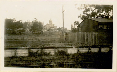
Photograph - Filling in the Outer Circle Railway cutting at East Kew, 1939
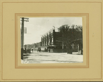
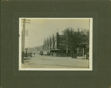
W.D. Vaughan (Kew's Civic Century, 1960, pp.195-6) quotes Council Minutes of 1938 and 1939 to record that: "After protracted negotiations between the Council, the Railways Department and the Tramways Board agreement was reached in June, 1938, for the filling of the railway cutting at the Harp Junction and shifting tram tracks to the High Street alignment ... The Outer Circle railway land from Princess Street to Park Crescent was purchased by the Kew Council in October, 1939, for 2,750 [pounds]. The land from Park Crescent to High Street was leased for 1 [pound] per annum. Considerable work was done in levelling the embankments to the original surface level."Important and rare photograph of the period, showing major works by Kew Council in Kew East working on a significant piece of urban infrastructure.Small, original black and white positive (photograph) showing workers and vehicles filling in the tracks of the former Outer Circle railway at East Kew. In the background is the metal bridge with brick piers, adjacent to the Harp Junction. The bridge crossed the cutting, linking the two parts of High Street. Behind the tip truck, painted on the side with the name 'Fowler Quarries' [located Keilor Road, North Essendon], one can see shops [including T.G. Garroway, Cash Grocer] in High Street. What appears to be the City of Kew Steamroller is immediately in front of the bridge. A group of passers-by watch from the bridge and from the road. Annotation in pencil on verso: "Filling in Outer Circle line at High St East Kew prior to straightening High St. (c. Feb 1930?)outer circle railway, railway cuttings, harp junction, high street -- kew east -
![The Punt, Echuca / [by] Nicholas Caire, circa 1876](/media/collectors/550653872162f11fb04854aa/items/57825721d0cdd1176ce1789a/item-media/57825765d0cdd1176ce19829/item-fit-380x285.jpg) Kew Historical Society Inc
Kew Historical Society IncPhotograph, Anglo-Australasian Photographic Company, The Punt, Echuca, c. 1876
Nicholas Caire was born on Guernsey in the Channel Islands in 1837. He arrived in Adelaide with his parents in about 1860. In 1867, following photographic journeys in Gippsland, he opened a studio in Adelaide. From 1870 to 1876 he lived and worked in Talbot in Central Victoria. In 1876 he purchased T. F. Chuck's studios in the Royal Arcade Melbourne. In 1885, following the introduction of dry plate photography, he began a series of landscape series, which were commercially successful. As a photographer, he travelled extensively through Victoria, photographing places few of his contemporaries had previously seen. He died in 1918. Reference: Jack Cato, 'Caire, Nicholas John (1837–1918)', Australian Dictionary of Biography.An original, rare photograph from the series 'Views of Victoria: General Series' by the photographer, Nicholas Caire (1837-1918). The series of 60 photographs that comprise the series was issued c. 1876 and reinforced a neo-Romantic view of the Australian landscape to which a growing nationalist movement would respond. Nicholas Caire was active as a photographer in Australia from 1858 until his death in 1918. His vision of the Australian bush and pioneer life had a counterpart in the works of Henry Lawson and other nationalist poets, authors and painters.Views of Victoria (General Series) No.34; ‘The Punt, Echuca’; Albumen silver photograph | Photo on card with Title and Description on reverse | Mounted 24 x 30 cm; Photo 12 x 17 cm.On Reverse: ‘The subject of this illustration is the principal crossing-place on the River Murray at Echuca, as regards the ordinary road traffic from the district of Riverina, New South Wales. After the periodical floods, the Punt is found to be insufficient for the large traffic; but this inconvenience will not be found to occur again to any great extent, as the new Railway Bridge from Moama will considerably lessen the road traffic through the Township of Echuca.’nicholas caire (1837-1918), echuca (vic), landscape photography -
![The Fairfield Bridge [circa 1891]](/media/collectors/550653872162f11fb04854aa/items/579eab98d0cdd117c4af1c89/item-media/579eac23d0cdd117c4afb1ad/item-fit-380x285.jpg) Kew Historical Society Inc
Kew Historical Society IncPrint, The Fairfield Bridge [circa 1891], c. 1891
This work forms part of the collection assembled by the historian Dorothy Rogers, that was donated to the Kew Historical Society by her son John Rogers in 2015. The manuscripts, photographs, maps, and documents were sourced by her from both family and local collections or produced as references for her print publications. Many were directly used by Rogers in writing ‘Lovely Old Homes of Kew’ (1961) and 'A History of Kew' (1973), or the numerous articles on local history that she produced for suburban newspapers. Most of the photographs in the collection include detailed annotations in her hand. The Rogers Collection provides a comprehensive insight into the working habits of a historian in the 1960s and 1970s. Together it forms the largest privately-donated collection within the archives of the Kew Historical Society.A reproduction of a photograph of the Fairfield Bridge. The bridge was one of the first constructed for the Outer Circle Railway in 1891. Its supervising engineer was [Sir] John Monash. The bridge was later to be repurposed as a road linking the Chandler Highway to Fairfield."Outer Circle Railway Bridge over River Yarra at Fairfield (last section of line opened 1891)"fairfield bridge, chandler highway bridge, dorothy rogers, john monash, outer circle railway -
 Kew Historical Society Inc
Plan - Subdivision Plan, Oswinia Estate, East Kew, c.1925
Prue Sanderson, in her groundbreaking ‘City of Kew Urban Conservation Study : Volume 2 - Development History’ (1988), summarised the periods of urban development and subdivisions of land in Kew. The periods that she identified included 1845-1880, 1880-1893, 1893-1921, 1921-1933, 1933-1943, and Post-War Development. These periods were selected as they represented periods of rapid growth or decline in urban development. An obvious starting point for Sanderson’s groupings involved population growth and the associated economic cycles. These cycles also highlighted urban expansion onto land that was predominantly rural, although in other cases it represented the decline and breakup of large estates. A number of the plans in the Kew Historical Society’s collection can also be found in other collections, such as those of the State Library of Victoria and the Boroondara Library Service. A number are however unique to the collection.Subdivision plans are historically important documents used as evidence of the growth of suburbs in Australia. They frequently provide information about when the land was sold on which a built structure was subsequently constructed as well as evidence relating to surveyors and real estate and financial agents. The numerous subdivision plans in the Kew Historical Society's collection represent working documents, ranging from the initial sketches made in planning a subdivision to printed plans on which auctioneers or agents listed the prices for which individual lots were sold. In a number of cases, the reverse of a subdivision plan in the collection includes a photograph of a house that was also for sale by the agent. These photographs provide significant heritage information relating house design and decoration, fencing and household gardens.The ‘Oswinia Estate’ subdivision in East Kew was planned and auctioned in the first half of the 1920s. 169 allotments were created in the triangular section of land bordered by High Street, Burke Road and the Government Boulevard (later Kilby Road). The only piece of land excluded was that where the previous Kew Pound had been located at the east tip of the triangle. Allotments were created fronting Glass, High, Namur, Oswin Streets, Irymple Avenue, and the Government Boulevard. The name for the Estate was derived from Oswin’s farm, which had been one of the largest landholdings in East Kew. The selling agents annotated the plan in our collection with crosses indicating those lots that had been sold. The inset locality plan is particularly interesting as it shows the route and stations of the Outer Circle Railway. When the subdivision plan was created, it included the proposed bridge over the Yarra at Burke Road. The bridge was to be officially opened in 1926.subdivision plans - east kew, oswinia estate, high street, glass street, namur street, government boulevard - kilby road, irymple street, oswin street -
 Kew Historical Society Inc
Plan, J R Mathers & McMillan, 5 Splendid vVlla Allotments,: Segtoune St. & Windsor St., Kew, 1928
Prue Sanderson, in her groundbreaking ‘City of Kew Urban Conservation Study : Volume 2 - Development History’ (1988), summarised the periods of urban development and subdivisions of land in Kew. The periods that she identified included 1845-1880, 1880-1893, 1893-1921, 1921-1933, 1933-1943, and Post-War Development. These periods were selected as they represented periods of rapid growth or decline in urban development. An obvious starting point for Sanderson’s groupings involved population growth and the associated economic cycles. These cycles also highlighted urban expansion onto land that was predominantly rural, although in other cases it represented the decline and breakup of large estates. A number of the plans in the Kew Historical Society’s collection can also be found in other collections, such as those of the State Library of Victoria and the Boroondara Library Service. A number are however unique to the collection.Subdivision plans are historically important documents used as evidence of the growth of suburbs in Australia. They frequently provide information about when the land was sold on which a built structure was subsequently constructed as well as evidence relating to surveyors and real estate and financial agents. The numerous subdivision plans in the Kew Historical Society's collection represent working documents, ranging from the initial sketches made in planning a subdivision to printed plans on which auctioneers or agents listed the prices for which individual lots were sold. In a number of cases, the reverse of a subdivision plan in the collection includes a photograph of a house that was also for sale by the agent. These photographs provide significant heritage information relating house design and decoration, fencing and household gardens.In 1928, five residential allotments bordering Segtoune and Windsor Streets were advertised for sale as part of a subdivision. Four of the blocks faced Segtoune Avenue. The auctioneers proclaimed the advantages of the sites: ‘Situate one minute from the High Street Electric Tram, which now runs direct to Spencer Street via Bridge Road and Flinders Street. Opposite the East Kew Railway Station (Outer Circle Line), which may be reopened In connection with the new Line from Kew to Doncaster; Adjacent lo the Kew Recreation Reserve, Sports Oval, and Swimming Bath; Half Minute from the Shopping Centre of East Kew, Accessible to the State School and Other Educational Centres’. The Harp of Erin Hotel and the route of the Outer Circle Railway line are marked on the plan. The Recreation Reserve and Sport Oval refer to Victoria Park. The Swimming Baths were located on the site of the current Kew Recreation Centre.subdivision plans - kew, segtoune street -- kew (vic.), windsor street -- kew (vic.) -
 Kew Historical Society Inc
Postcard, R McGeehan, The Effect of Storm. Train Passing Through Flood Waters, South Yarra, 25-1-07, 1907
SHARP DOWNPOUR. ONE INCH IN 45 MINUTES. SOUTHERN SUBURBS DELUGED. TRAIN STOPPED AT SOUTH YARRA. One of the sudden downpours of rain which occasionally fall in Melbourne occurred yesterday afternoon, when nearly an inch of rain fell in the course of three quarters of an hour, and caused a flood for an hour or two in certain localities. During the early part of the day, the sky had been clouded over, but there was nothing to indicate a storm of such intensity as that which followed. At about half-past 1 o'clock residents of South Yarra, South Melbourne, Prahran, and St. Kilda noticed a few drops of rain. Still, it appeared unlikely that there would be anything exceptional, until with startling suddenness at about 10 minutes to 1 o'clock, one of the heaviest downpours within the memory of residents burst upon those suburbs. A strange feature of the storm was that it was practically confined to an area of about three miles square. The city was but little affected, though at a spot as close as the Observatory 86 points of rain were recorded in three-quarters of an hour. Thunder and lightning accompanied the downpour, which was cyclonic in character, the rain driving heavily from all points of the compass as the cyclone passed. It was in South Yarra and Prahran that the rain fell heaviest. Within a few minutes after it commenced, the low-lying portions of Toorak-road and practically the whole length of Chapel-street were under water. The depression at the intersection of Toorak-road and Darling-street speedily filled to the dimensions of a small lake. Several shops were inundated, while the water from the higher levels rushed down like a mountain torrent, and in several in-stances swept through the rear of houses and shops, carrying furniture in a floating mass against the further walls. In one case a footbridge was carried bodily away and dashed to pieces. Darling-street itself Great Davis-street, and other low-lying and flat thoroughfares in the vicinity became flooded from kerb to kerb, while on the other side of the railway-bridge the valley between Kensington-road and River-street became filled for some minutes to a depth of several feet. Meanwhile the waters from South Yarra hill, seeking a lower level, found it in the railway cutting, and the excavations from South Yarra station to Prahran on the one line, and to the Chapel-street bridge on the other, were converted into a couple of canals. At the platforms at South Yarra the water was two feet deep on the permanent way, and towards Hawksburn, at the sudden depression under Chapel-street bridge, it was at one time deep enough to cover a tall man's head. Into this swirling mass of water the 1:50 p.m. train from Oakleigh plunged on its way to Melbourne. The impact caused a mighty fountain of water to rise to a height of about 20 feet above the level of Chapel-street and send clouds of spray in all directions. Under the belief that a terrible explosion had occurred residents braved the rain and rushed to the spot, only to find that the train had been brought to a stand-still in the middle of what seemed to be a river. The water was so high that it had entered the fire-box from below, extinguishing the fires and cutting off the steam supply. In the meantime the officials at the South Yarra station had been preparing for emergencies. Inspectors were on duty at intervals along the line, and the moment the alarm was given an extra engine was backed carefully down and continued on to connect with the stranded train without losing its own power. There was a delay of about ten minutes in the service for an hour or two, but by 5 o'clock all the trains were running on time again, and the water had run off all but the spot beneath the Chapel-street bridge. Here the water remained about four feet deep until nightfall, and throughout the afternoon several hundreds of people including biograph operators and photographers, were gathered around watching each train pass through. Even with the water two feet lower, this was a work attended with considerable difficulty. Each train had to absolutely force its way through the weight of water, almost enveloped by the spray thrown up, and it was only just able to negotiate the "ford" by using every ounce of steam. ... The Argus, 26 January 1907, p19.The item forms part of the Laurie Bennett collection of thirty-six postcards and photographs of Kew and early Melbourne, donated to the Kew Historical Society in 1980. The postcards in the Bennett collection, like other images in the Society's holdings date from the 1890s to the present and comprehensively indicate points-of-view or scenes considered historically, aesthetically or socially significant in the period in which they were produced.Postcard depicting a flood at South Yarra Station in 1907. The title and photographer's name are identified on the front of the postcard. Donated by L. Bennett, 1980flood - south yarra, trains - melbourne, postcards, r mcgeehan - prahran -
 Sunbury Family History and Heritage Society Inc.
Photograph, c1900s
The people in the horse and cart are driving their vehicle over the original Macedon Road bridge which spans the Jacksons Creek in Sunbury. In the 1970s the road was diverted to take out the downhill bend at the approach to the bridge and a newer bridge was built close to the original one, which now takes pedestrian traffic.The original Macedon Street bridge is one of five heritage bridges in Sunbury. Two of them are built along Macedon Street and the other three are along the railway line.A sepia photograph in post card format of two people in a horse and cart going over a bridge with trees on each side of them.macedon street bridge, jacksons creek, sunbury -
 Port Fairy Historical Society Museum and Archives
Photograph
Aerial-Port Fairy 1972Coloured aerial photograph aerial, moyne river, douglas house, railway, water tower, traffic bridge, pedestrian bridge -
Canterbury History Group
Photograph - Canterbury Road, c1970
... melbourne Canterbury Canterbury Road Carnell & Sons Railway Bridges ...Black & white photograph of Canterbury Road shops looking to the east from Balwyn Road. c1970.canterbury, canterbury road, carnell & sons, railway bridges -
Canterbury History Group
Document - Canterbury Railway Station, Guiney, Michael, 2011
Four pages of historical information of the development of railway services in Canterbury. Includes contract and correspondence numbers and dates from 28 December 1880 to 19 December 1971canterbury, canterbury railway station, canterbury road, signal boxes, railway crossings, railway gates, railway bridges, railway lines, stationmasters houses, victorian railways -
Canterbury History Group
Document - Canterbury. Provision of Railway Bridge - Up Line, Office of Chief Traffic Manager, 9/09/1968 12:00:00 AM
... Railways Railway Bridges Railway Lines Trains Notification from ...Notification from Victorian Railways of the new railway bridge being opened for the Up Line service on Sunday 15 September 1968canterbury, canterbury station, canterbury road, victorian railways, railway bridges, railway lines, trains -
 Melton City Libraries
Photograph, Melton Railway Bridge, c.1884
"The Melton Viaduct, opened in 1886, is of State heritage significance as a very large and visually distinctive wrought iron, lattice girder trestle bridge over the Werribee River (now Melton Reservoir). It comprises 18.3 and 9.1 metre spans, in a generally alternate arrangement, of total length 375 metres, and standing 38 metres over the Werribee River. Wrought iron small section iron was used to build tension trussed trestle legs, which supported four lines of rivetted wrought-iron deck-type double lattice trusses. It has bluestone abutments and pier bases of coursed rock-faced bluestone with drafted margins. The larger half-piers, now usually submerged in the Melton Reservoir have sharp tapered cutwaters and curved coping at the tops. While designed to carry two rail tracks it has only ever been used as a single track line. Despite several alterations to its deck structure, it remains an outstanding example of a lighter structural design employing open metal trestle supports and metal truss girders. The direct Melbourne to Ballarat railway link of which the Melton viaduct was the major engineering work contributed significantly to the history and development of Victoria. This new link reflected Ballarat’s diversifying economy as well as the commercial and political influence of the metropolis. Construction of the bridge, and the associated large workers camp, were extensively photographed, documenting an important episode in local history. The railway enabled the development of new industries in the Melton area, notably the timber industry and a chaff industry of national importance, greatly facilitated the later transition of the Shire from a pastoral to a farming economy, and struck a major blow to Melton township’s era as a wayside town servicing Ballarat road (especially coach) traffic". Melton Railway Bridge being built across the Werribee Rivertransport