Showing 111528 items matching "road"
-
 Eltham District Historical Society Inc
Photograph, Looking south along Main Road from just north of Elsa Court, Eltham, February 1968, Feb 1968
Shows where the future duplication of Main Road ends just north of Elsa Court.In February 1968 an unknown person took a series of photos from the Eltham Hotel at Pitt Street heading north along Main Road through the shopping centre to just north of Elsa Court covering the length of the section of Main Road which was duplicated shortly thereafter. Shows the condition and environment of the streesscape of Main Road, Eltham immediately prior to the duplication between Pitt Street and Elsa Court through the shopping centre. Also shows a number of shops and businesses that operated at that time.Black and white photographduplication, eltham, main road, elsa court, railway line -
 Eltham District Historical Society Inc
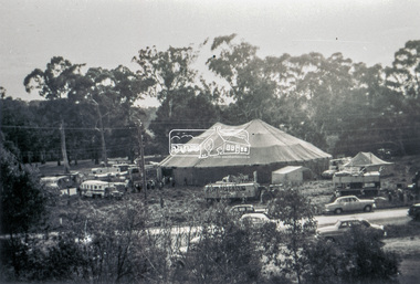
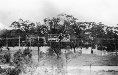
Slide - Photograph, Grace Mitchell, Ashtons Circus set up in Bremner's Reserve, Main Road, Eltham, c.1955
View from Grace Mitchell's shop at the corner of Mount Pleasant Road and Main Road. Grace Mitchell was probably best known for her Eltham shop at the corner of Mt Pleasant Road and Main Road. Grace's memories covered many local identities who were patrons of her shop between 1954 and 1971. From the elevated position of her shop and home Grace was able to view a varied passing parade of Eltham events from ERSILAC, Easter and Eltham Festival parades passing on their way to Eltham Lower Park, circuses in Wingrove Park (then Bremner’s Reserve), roadworks and other happenings. Bremner's Reserve was renamed Wingrove Park c.1970 This photo was from a series of images presented by Grace Mitchell at a Society talk 10 March 1993 on the theme of “My Eltham”.35mm Kodak 5052 TMX Black and White transparency, 1 strip, 6 frames Black and white print 17 x 25.4 cmashtons circus, bremner's flat, circus, grace mitchell, main road, mount pleasant road, wingrove park -
 Eltham District Historical Society Inc
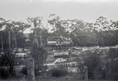
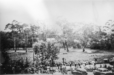
Photograph, Grace Mitchell, Bremners Flat, Main Road, Eltham, 1958c
View from Grace Mitchell's shop at the corner of Mount Pleasant Road and Main Road. Grace Mitchell was probably best known for her Eltham shop at the corner of Mt Pleasant Road and Main Road. Grace's memories covered many local identities who were patrons of her shop between 1954 and 1971. From the elevated position of her shop and home Grace was able to view a varied passing parade of Eltham events from ERSILAC, Easter and Eltham Festival parades passing on their way to Eltham Lower Park, circuses in Wingrove Park (then Bremner’s Reserve), roadworks and other happenings. Bremner's Reserve was renamed Wingrove Park c.1970 This photo was from a series of images presented by Grace Mitchell at a Society talk 10 March 1993 on the theme of “My Eltham”.Black and white print 17 x 25.4 cmbremner's flat, main road, mount pleasant road, wingrove park -
 Eltham District Historical Society Inc
Photograph, Grace Mitchell, Diamond Creek in flood, Bremners Flat, Main Road, Eltham, c.1958
View from Grace Mitchell's shop at the corner of Mount Pleasant Road and Main Road. Grace Mitchell was probably best known for her Eltham shop at the corner of Mt Pleasant Road and Main Road. Grace's memories covered many local identities who were patrons of her shop between 1954 and 1971. From the elevated position of her shop and home Grace was able to view a varied passing parade of Eltham events from ERSILAC, Easter and Eltham Festival parades passing on their way to Eltham Lower Park, circuses in Wingrove Park (then Bremner’s Reserve), roadworks and other happenings. Bremner's Reserve was renamed Wingrove Park c.1970 This photo was from a series of images presented by Grace Mitchell at a Society talk 10 March 1993 on the theme of “My Eltham”.Black and white print 17 x 25.4 cmbremner's flat, diamond creek, floods, main road, mount pleasant road, wingrove park -
 Eltham District Historical Society Inc
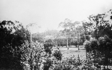
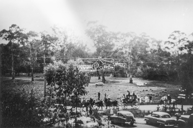
Photograph, Grace Mitchell, Possibly the Ersilac Parade travelling along Main Road, Eltham, c.1958
View from Grace Mitchell's shop at the corner of Mount Pleasant Road and Main Road. Grace Mitchell was probably best known for her Eltham shop at the corner of Mt Pleasant Road and Main Road. Grace's memories covered many local identities who were patrons of her shop between 1954 and 1971. From the elevated position of her shop and home Grace was able to view a varied passing parade of Eltham events from ERSILAC, Easter and Eltham Festival parades passing on their way to Eltham Lower Park, circuses in Wingrove Park (then Bremner’s Reserve), roadworks and other happenings. Bremner's Reserve was renamed Wingrove Park c.1970 This photo was from a series of images presented by Grace Mitchell at a Society talk 10 March 1993 on the theme of “My Eltham”.Black and white print 17 x 25.4 cmcars, bremner's flat, eltham, ersilac parade, main road, mount pleasant road, wingrove park, festival, horse drawn carriage -
 Eltham District Historical Society Inc
Photograph, Grace Mitchell, Possibly the Ersilac Parade travelling along Main Road, Eltham, 1958c
View from Grace Mitchell's shop at the corner of Mount Pleasant Road and Main Road. Grace Mitchell was probably best known for her Eltham shop at the corner of Mt Pleasant Road and Main Road. Grace's memories covered many local identities who were patrons of her shop between 1954 and 1971. From the elevated position of her shop and home Grace was able to view a varied passing parade of Eltham events from ERSILAC, Easter and Eltham Festival parades passing on their way to Eltham Lower Park, circuses in Wingrove Park (then Bremner’s Reserve), roadworks and other happenings. Bremner's Reserve was renamed Wingrove Park c.1970 This photo was from a series of images presented by Grace Mitchell at a Society talk 10 March 1993 on the theme of “My Eltham”.Black and white print 17 x 25.4 cmcars, bremner's flat, eltham, ersilac parade, main road, mount pleasant road, wingrove park, festival, horse drawn carriage -
 Eltham District Historical Society Inc
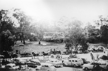
Photograph, Grace Mitchell, Possibly the Ersilac Parade travelling along Main Road, Eltham, c.1958
View from Grace Mitchell's shop at the corner of Mount Pleasant Road and Main Road. Grace Mitchell was probably best known for her Eltham shop at the corner of Mt Pleasant Road and Main Road. Grace's memories covered many local identities who were patrons of her shop between 1954 and 1971. From the elevated position of her shop and home Grace was able to view a varied passing parade of Eltham events from ERSILAC, Easter and Eltham Festival parades passing on their way to Eltham Lower Park, circuses in Wingrove Park (then Bremner’s Reserve), roadworks and other happenings. Bremner's Reserve was renamed Wingrove Park c.1970 This photo was from a series of images presented by Grace Mitchell at a Society talk 10 March 1993 on the theme of “My Eltham”.Black and white print 17 x 25.4 cmcars, bremner's flat, eltham, ersilac parade, main road, mount pleasant road, wingrove park, festival, horse drawn carriage -
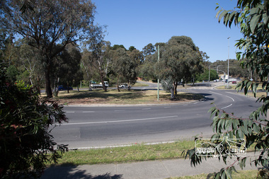
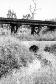 Eltham District Historical Society Inc
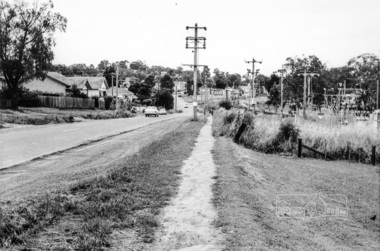
Photograph, Looking west from Main Road from just north of intersection with Diamond Street, Eltham, February 1968, Feb 1968
The watercourse passes under the road and railway at this point. Significant flash flooding occurred along this water course on Christmas Day 2011 causing significant damage to the railway line and road and flooding of Judge Book Village. The drain was swept away including the support pillars of the rail lines timber framework. Judge Book Village had some 40 units flooded before the water entered Diamond Creek. The water had flowed down and flooded Valonia Drive then Grove Street before flowing down the watercourse to Main RoadIn February 1968 an unknown person took a series of photos from the Eltham Hotel at Pitt Street heading north along Main Road through the shopping centre to just north of Elsa Court covering the length of the section of Main Road which was duplicated shortly thereafter. Shows the condition and environment of the streesscape of Main Road, Eltham immediately prior to the duplication between Pitt Street and Elsa Court through the shopping centre. Also shows a number of shops and businesses that operated at that time.Black and white photographduplication, eltham, main road, diamond street, watercourse, drainage, railway line -
 Ringwood and District Historical Society
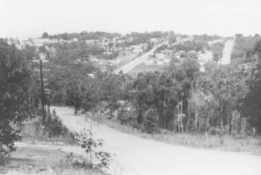
Photograph, View of Glenvale Road, Ringwood. Warnes Road in left background 1964
See Also #25Written on back of photograph, "1964 - View of Glenvale Road. Supplied by Garrett Gundry. Warnes Road in left background. Deep Creek Road in centre background." -
 Eltham District Historical Society Inc
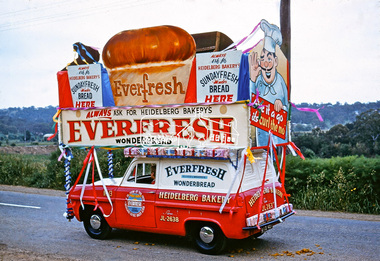
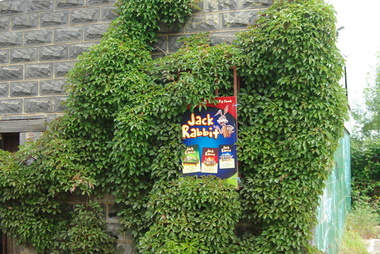
Photograph, Heidelberg Bakery display, Ersilac Parade, Main Road, Eltham, c.1960, 1960c
Heading south along Main Road approaching Bridge Street. Registration GIB is c.1955Digital file only (Wes's 35mm)don muir collection, heidelberg bakery display, ersilac parade, main road, eltham, c.1960 -
 Greensborough Historical Society
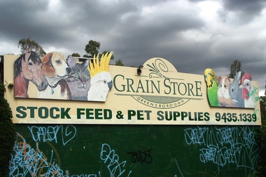
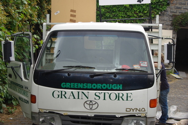
Photograph - Digital Image, Marilyn Smith, Greensborough Grain Store, 183 Para Road. Signs, 06/11/2017
This photograph shows signage at 183 Para Road when the building was used for Greensborough Grain Store.Digital copy of colour photographgreensborough grain store, para road greensborough -
 Greensborough Historical Society
Photograph - Digital Image, Marilyn Smith, Greensborough Grain Store, 183 Para Road. Exterior, 06/11/2017
This photograph shows the exterior of the building at 183 Para Road when it was used for Greensborough Grain Store.In 2017, the Greensborough Grain Store closed its Para Road premises and now trades online.Digital copy of colour photographgreensborough grain store, para road greensborough -
 Eltham District Historical Society Inc
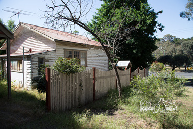
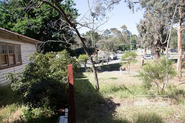
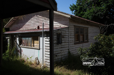
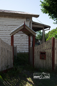
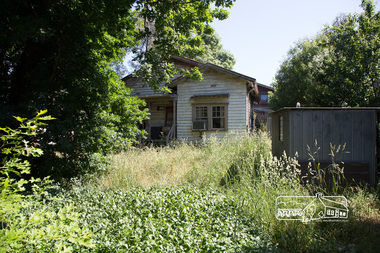
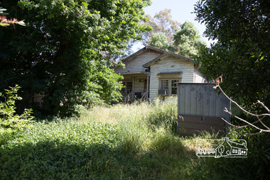
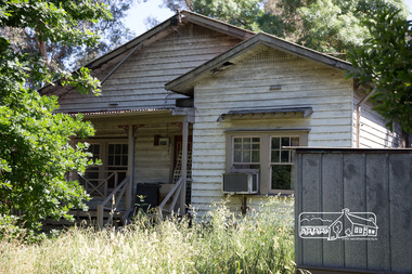
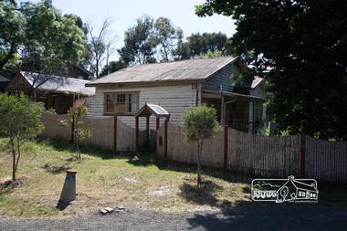
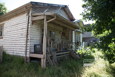
Photograph, Peter Pidgeon, Derelict house, 528 Main Road, Eltham, 13 November 2017, 13/11/2017
House dates back to early 1930s. Situated adjacent to intersection of Main Road and Fitzsimons LaneBorn Digitaleltham, streets, main road, fitzsimons lane -
 Eltham District Historical Society Inc
Photograph, Peter Pidgeon, Derelict house, 528 Main Road, Eltham, 13 November 2017, 13/11/2017
House dates back to early 1930s. Situated adjacent to intersection of Main Road and Fitzsimons LaneBorn Digitaleltham, streets, main road, fitzsimons lane -
 Eltham District Historical Society Inc
Photograph, Peter Pidgeon, Derelict house, 528 Main Road, Eltham, 13 November 2017, 13/11/2017
House dates back to early 1930s. Situated adjacent to intersection of Main Road and Fitzsimons LaneBorn Digitaleltham, streets, main road, fitzsimons lane -
 Eltham District Historical Society Inc
Photograph, Peter Pidgeon, Derelict house, 528 Main Road, Eltham, 13 November 2017, 13/11/2017
House dates back to early 1930s. Situated adjacent to intersection of Main Road and Fitzsimons LaneBorn Digitaleltham, streets, main road, fitzsimons lane -
 Eltham District Historical Society Inc
Photograph, Peter Pidgeon, Derelict house, 528 Main Road, Eltham, 13 November 2017, 13/11/2017
House dates back to early 1930s. Situated adjacent to intersection of Main Road and Fitzsimons LaneBorn Digitaleltham, streets, main road, fitzsimons lane -
 Eltham District Historical Society Inc
Photograph, Peter Pidgeon, Derelict house, 528 Main Road, Eltham, 13 November 2017, 13/11/2017
House dates back to early 1930s. Situated adjacent to intersection of Main Road and Fitzsimons LaneBorn Digitaleltham, streets, main road, fitzsimons lane -
 Eltham District Historical Society Inc
Photograph, Peter Pidgeon, Derelict house, 528 Main Road, Eltham, 13 November 2017, 13/11/2017
House dates back to early 1930s. Situated adjacent to intersection of Main Road and Fitzsimons LaneBorn Digitaleltham, streets, main road, fitzsimons lane -
 Eltham District Historical Society Inc
Photograph, Peter Pidgeon, Derelict house, 528 Main Road, Eltham, 13 November 2017, 13/11/2017
House dates back to early 1930s. Situated adjacent to intersection of Main Road and Fitzsimons LaneBorn Digitaleltham, streets, main road, fitzsimons lane -
 Eltham District Historical Society Inc
Photograph, Peter Pidgeon, Derelict house, 528 Main Road, Eltham, 13 November 2017, 13/11/2017
House dates back to early 1930s. Situated adjacent to intersection of Main Road and Fitzsimons LaneBorn Digitaleltham, streets, main road, fitzsimons lane -
 Eltham District Historical Society Inc
Photograph, Peter Pidgeon, Derelict house, 528 Main Road, Eltham, 13 November 2017, 13/11/2017
House dates back to early 1930s. Situated adjacent to intersection of Main Road and Fitzsimons LaneBorn Digitaleltham, streets, main road, fitzsimons lane -
 Eltham District Historical Society Inc
Photograph, Peter Pidgeon, Derelict house, 528 Main Road, Eltham, 13 November 2017, 13/11/2017
House dates back to early 1930s. Situated adjacent to intersection of Main Road and Fitzsimons LaneBorn Digitaleltham, streets, main road, fitzsimons lane -
 Eltham District Historical Society Inc
Photograph, Peter Pidgeon, Derelict house, 528 Main Road, Eltham, 13 November 2017, 13/11/2017
House dates back to early 1930s. Situated adjacent to intersection of Main Road and Fitzsimons LaneBorn Digitaleltham, streets, main road, fitzsimons lane -
 Whitehorse Historical Society Inc.
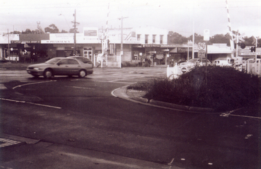
Photograph, Railway crossing on Springvale Road, 1/06/2009
One of a collection of photographs taken of the Nunawading Railway Station prior to the lowering of the railway line and building of the new railway station on the western side of Springvale Road so that the Springvale Road Rail Crossing can be eliminated.Black & white photograph of the precinct surrounding the Nunawading Station and the Springvale Road Railway crossing. This photograph is the railway crossing with Springvale Road, Nunawading, taken from the north west corner looking over crossing to some of the Nunawading shops. See NP 3545 to NP3567 for the complete set of photographsnunawading railway station, springvale road nunawading, redevelopment of railway line/springvale road., nunawading recreation centre -
 Whitehorse Historical Society Inc.
Document, 520 Mitcham Road, 2005
Papers relating to objections to development of 520-528 Mitcham Road Mitcham.Papers relating to objections to development of 520-528 Mitcham Road Mitcham. Includes: statement by Neil Edwin Kerby & Margaret Anne Kerby; Title searches for 449 Mitcham Road Mitcham and adjacent properties; plan of 1906 subdivision; ASIC extract of development company organisational details; aerial photos of the area; photographs of nearby properties and of Mitcham Road streetscapes and list of Mitcham objectors. CD copy at NP3771Papers relating to objections to development of 520-528 Mitcham Road Mitcham. mitcham road mitcham, nos. 520-528, kerby, neil edwin, kerby, margaret anne, mitcham road mitcham no. 449, 520 mitcham road pty ltd, listermay nominees pty ltd, land subdivision -
 Greensborough Historical Society
Photograph - Digital Image, Marilyn Smith, Greensborough Grain Store, 183 Para Road. Delivery truck, 06/11/2017
This photograph shows delivery truck at 183 Para Road when the building was used for Greensborough Grain Store.In 2017, the Greensborough Grain Store closed its Para Road premises and now trades online.Digital copy of colour photographgreensborough grain store, para road greensborough -
Greensborough Historical Society
Photograph - Digital Image, Marilyn Smith, Greensborough Grain Store, 183 Para Road. Closure notice, 04/10/2017
This Facebook post explains the move by Greensborough Grain Store to close the business at 183 Para Road in 2017.In 2017, the Greensborough Grain Store closed its Para Road premises and now trades online.Digital copy of Facebook postgreensborough grain store, para road greensborough -
 Surrey Hills Historical Society Collection
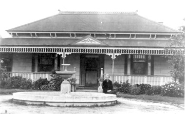
Photo, 'Spenceycroft', Canterbury Road
The photo is of ‘Spenceycroft’ at 654 Canterbury Road, Surrey Hills. For many years this home was hidden behind a large fence sheltering it from the noise of traffic along Canterbury Road, however it dates back to the very early days of settlement in the Surrey Hills area. Canterbury Road was then known as Delany’s Road. ‘Spenceycroft’ is thought to incorporate part of the original farmhouse built on the site by George Klepper, who planted a vineyard in the area. George’s family was one of a number of German families who settled in Surrey Hills during the later part of the 19th century. Later, the land associated with ‘Spenceycroft’ was worked as a dairy farm by James and Elizabeth Rayment. In recent years 'Spenceycroft' has been sold several times and has become increasingly derelict. Sold again in 2015 when it had become quite derelict, it was demolished and re-developed.A black & white photo of double-fronted Victorian style home with a fountain centre front and low foliage in front of the veranda. A woman is sitting by the fountain. 'spenceycroft', canterbury road, james rayment, elizabeth rayment, george klepper