Showing 554 items matching "significant trees"
-
 City of Kingston
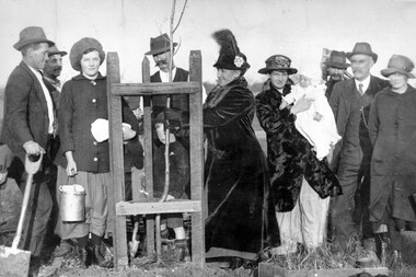
Photograph - Black and white, c. 1917
Members of the local community have gathered to plant an avenue of honour. Through community fundraising, funds for over 140 trees had been raised.An avenue of honour was planted after World War I (WWI) to commemorate those from the area who had died during service. The arboreal Avenue of Honour has been an enduring and highly popular form of public commemoration of military service in Australia. With a significant groundswell of community endeavour, as a nation, Australians have chosen to recognise service, sacrifice and suffering through community plantings of memorial Avenues of Honour. The earliest recorded Avenues of Honour were created in response to Australia’s participation in the Boer War, but the majority were established during and after World War I and, to a lesser extent, World War II. (https://avenuesofhonour.org/about/)A group of about eleven (11) people, including children and a baby, have gathered to plant trees along to create an avenue of honour for the fallen of World War I (WWI). From left to right: Moss Daff, Mr Stratford, Alice Edwards, Len Alln with Ron Allan, Mrs Wood (sen), Mrs Wood (jnr) with baby, name unrecorded, Mr McKittrick and Maud Edwards. White round sticker with black printed text on reverse: 99 Handwritten in red ink: 50%cheltenham, world war i, commemoration, avenue of honour -
 Wodonga & District Historical Society Inc
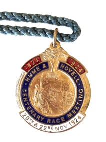
Memorabilia - Hume and Hovell Centenary Race Meeting - Albury
Great celebrations took place in Albury, NSW for the celebration of the Centenary of the Hume and Hovell expedition. The Hume and Hovell journey of discovery to Port Phillip took place during 1824-1825. On November 20, 1824, they successfully crossed the Murray River not far from Albury and proceeded on a route to Port Phillip. To celebrate the Centenary of this crossing, the city of Albury held a series of activities during the week of Sunday 16th November to Saturday 22nd November 1924. As part of these celebrations the Albury Race Club held a special race meeting conducted on Thursday 20th and Saturday 22nd November 1924. This badge was produced as a memorabilia for that meeting. Prize money over the two day meeting totalled over £3,000. The star events were the Centenary Cup of I mile and 3 furlongs with a prize of £1000 (one thousand pounds) and a Gold Cup valued at one hundred guineas, donated by Mrs. Jas. Mitchell of Tabletop, and the John Campbell Handicap of one mile carrying $500 and trophy valued at 50 guineas donated by the chairman of the Club, Mr. J. Campbell. A gold whip donated by Mr. Norman Crow was presented to the jockey riding the Cup winner. This item is significant because it is an example of memorabilia produced for the centenary celebrations for the Hume and Hovell Expedition.An enamelled fob medallion featuring a central image with a tree at the top and text. The tree is the Hovell Tree at Albury. The central image is of indigenous man facing Albury’s civic buildings with the Murray River in between. The fob is attached to a blue twisted cord.1824 1924 HUME & HOVELL CENTENARY RACE MEETING 20th and 22nd Nov 1924 On back: 244B SIMPSONhume & hovell, hume & hovell centenary, albury race club -
 Merri-bek City Council
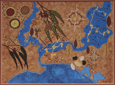
Acrylic on watercolour paper, Mandy Nicholson, Cultural Map of Melbourne, 2003
Primarily a painter, Mandy Nicholson also produces ceramics, carvings, murals, prints, designs and children’s clothing. Born in 1975, Nicholson was raised in Healesville and belongs to the Wurundjeri-willam (Woiwurrung language) clan of the Kulin Nation. Mandy’s paintings often represent important cultural rituals and are executed in her distinct graphic style using the traditional motifs of her people blended with contemporary interpretation. Cultural Map of Melbourne shows significant sites across Melbourne. These include scar trees, corroboree trees, stone quarries, bush tucker sites, significant rivers, fresh water wells and traditional campsites. -
 Eltham District Historical Society Inc
Photograph - Digital Photograph, Alan King, Stonygrad, 34 Hamilton Road, North Warrandyte, 30 January 2008
Vassilieff dynamited rock from his own property to build his house. Stonygrad is reminiscent of a grotto and in parts, of a sculpture. Covered under Heritage Overlay, Nillumbik Planning Scheme. Published: Nillumbik Now and Then / Marguerite Marshall 2008; photographs Alan King with Marguerite Marshall.; p135 Stonygrad, the home built by Expressionist painter and sculptor Danila Vassilieff, is reminiscent of a grotto and in parts, of a sculpture. Vassilieff, who amongst others influenced painter Sydney Nolan and Albert Tucker, was a member of the artists group the Angry Penguins. He was also a highly regarded art teacher at the nearby Koornong Experimental School and taught at Eltham High School. Art critic Robert Hughes described Vassilieff’s painting as ‘lyrical without social commentary’, and said Vassilieff was ‘the most oddly neglected artist in recent Australian History’. Vassilieff, who was born in 1897 in Russia, had an unusually adventurous life before he settled in Warrandyte. The 12th of 18 children, he lived on a farm in the Don Basin. Vassilieff trained with the Imperial Military Academy at St Petersburg and fought in World War One as an officer in the White Russian Army against the communists. In 1920 he was captured, then escaped from prison, stole a horse and rode bareback 150 miles to the Black Sea, helped at first by Tartar freebooters. He then travelled to India, Shanghai and arrived in Queensland as a refugee in 1923 where he began painting. He and his wife Anisia bought a sugar farm near Ingram, and later he constructed railway lines at Mataranka, in the Northern Territory.4 In 1929 Vassilieff went to Brazil for formal art training from former fellow-officer Dmitri Ismailovich, but he soon left to travel up the Amazon River. He then worked as a sidewalk artist in the West Indies and travelled for two years in England, France and Spain. In 1937 he arrived in Melbourne where he lived until his death in 1958. His first major Australian series was the Carlton streetscapes and from 1951 he sculpted in local hard limestone. Vassilieff rejected all dogma and regarded religious subjects as suitable only for decorative arts. In 1944 he helped defeat a communist attempt to take over the Contemporary Art Society. For a short time, from around 1955, Vassilieff taught at various Victorian schools. The Angry Penguins painted mainly between 1937 and 1947, and included Arthur Boyd, Albert Tucker, Sidney Nolan and Joy Hester. The group formed as they felt isolated from European thought and art (including Surrealism) from which their work was derived. They were also angry at what they considered to be the complacency and insularity of their society. They maintained Australians at first were scarcely aware of the threats of the Wall Street Crash and Hitler and were little interested in the Spanish Civil War. The Angry Penguins also objected to the White Australia Policy. Hughes said although most of the Melbourne Expressionists in the 1940s were unskilled and their work crude in style, they helped jolt Australian painting from its pastoral complacency. Their style influenced nearly every painting produced by significant figurative artists in Melbourne in the 1950s such as Charles Blackman. From 1939 Vassilieff built Stonygrad, mainly with local stone. The house stands at the end of a private road surrounded by trees with the quiet occasionally broken by the sounds of bellbirds. To build his house Vassilieff dynamited rock and cut trees from his own property. The original section of the three-level house is of irregular-shaped pieces of solid stone, exposed inside like the exterior. Vassilieff later built sections with timber and brick. Inside is rustic and cave-like, and several rooms are linked by arched openings with no doors. One undulating wall was carved out of rock from which two sculptured heads protrude. Several ceilings are of rough-hewn logs and the built-in table and bookcase are rough, as is a timber ladder leading to a bedroom. Not for the elderly or unsteady! Yet the general impression in the muted light is beautiful, with artistic originality.This collection of almost 130 photos about places and people within the Shire of Nillumbik, an urban and rural municipality in Melbourne's north, contributes to an understanding of the history of the Shire. Published in 2008 immediately prior to the Black Saturday bushfires of February 7, 2009, it documents sites that were impacted, and in some cases destroyed by the fires. It includes photographs taken especially for the publication, creating a unique time capsule representing the Shire in the early 21st century. It remains the most recent comprehenesive publication devoted to the Shire's history connecting local residents to the past. nillumbik now and then (marshall-king) collection, danila vassilieff, hamilton road, north warrandyte, stonygrad -
 Eltham District Historical Society Inc
Photograph - Digital Photograph, Alan King, St Andrews Hotel, 2 February 2008
The c1860 St Andrews Hotel, with the c1930 additions, and the Canary Island Palm, and the surrounding site to the title boundaries are historically, socially and aesthetically significant to the Shire of Nillumbik. The St Andrews Hotel is historically significant because it may have given its name 'St Andrews' to the town (another suggestion is that the name came from St Andrews church) and for its connection to Ewen Hugh Cameron (1831-1915) the prosperous local farmer, member of the Eltham Roads Board/Shire Council and local MP. It is also significant as the oldest hotel building in the former Shire of Eltham, as one of the few surviving buildings connected with the Caledonian goldfields era and as one of a handful of early structures to have survived the 1960s bushfires; the additions and alterations to the hotel reflect its long life. The hotel is socially significant because it has served as an important meeting place for more than 160 years. The Canary Island Palm is historically significant as a rare example of exotic tree planting in this rural area. The tree is aesthetically and historically significant as a local landmark and for its contribution to the streetscape and landscape value. Covered under Heritage Overlay, Nillumbik Planning Scheme. Published: Nillumbik Now and Then / Marguerite Marshall 2008; photographs Alan King with Marguerite Marshall.; p71 Built around 1860, St Andrews Hotel has changed little since it first welcomed thirsty gold diggers from the Caledonia Goldfields. The timber building, with gabled roof, beamed ceilings and a massive fireplace, is Nillumbik Shire’s oldest hotel and has always been an important community centre, particularly in its early days. Fortunately, the hotel and the near-by Canary Island Palm Tree, which is quite rare in this area, survived the 1960s bushfires, along with a few other early buildings. St Andrews (formerly Queenstown) was founded on gold, as were Panton Hill (formerly Kingstown), Research and Diamond Creek, from the mid-1850s to the 1860s. But by the early 20th century common use changed the name Queenstown to St Andrews, possibly after this hotel or after the church or the mining district.1 The Caledonia Diggings were probably named by Scottish settlers after the Roman name for Scotland, despite this land bearing little similarity to their homeland.2 Queenstown, which was proclaimed as a township in 1861, was the gold-mining centre on the Upper Diamond and in the 1850s had up to 600 European inhabitants and a small camp of Chinese on the flats along the creek. Queenstown was the administrative centre of the Upper Diamond with three hotels, a brewery and a slaughterhouse.3 It is unclear which hotel was the district’s first, as distinct from the earliest unlicensed grog shops, some of which operated in tents. John Corke Knell was one of eight unlicensed storekeepers supplying drink to miners at Caledonia in 1857, named by Sgt. McNamara of the Caledonia Police Station.4 In February 1859, Knell apparently bought most of the present hotel’s site at the first township land sales. As he was a local storekeeper, he might have first established a store there.5 Knell and his wife Eliza were early licensees of the St Andrews Hotel. The hotel had eight bedrooms – including three for public use – and the dining-room seated 30 people. It is thought they named the hotel St Andrews after Eliza’s hometown of St Andrews in Scotland. St Andrews Hotel was an important local centre in several ways. In the same building the Knells also operated a post office and general store. In 1867 Mrs Knell was appointed Deputy Registrar of Births and Deaths for Queenstown. The hotel was also used to hold inquests into people’s deaths when the police residence became too small.6 The hotel also became a fashionable destination at Christmas for parties from Melbourne. In 1868, possibly following her husband’s death, Mrs Knell applied for a temporary licence, which was then transferred to Robert Smith after their marriage in 1869. But then, possibly after Robert’s death, Mrs Smith operated the hotel until 1892. This contradicts a report in The Evelyn Observer 1882 that JC Knells of the St Andrews Hotel was granted a publican’s licence in the Queenstown Police Court. At that time he was supposed to have been dead for around 14 years! Although Mrs Smith was a respected citizen, known for her geniality and as an ideal hostess, she had a minor brush with the law when she was fined ten shillings for not lighting a lamp outside her licensed premises.7 From 1892 several publicans owned the hotel including W Atkins, from 1895. In 1909 the licensee was apparently Mrs Smith’s son, Walter Knell, who held the licence until at least the 1920s. Not surprisingly, this old hotel has attracted romantic stories. Mrs Smith is said to be seen roaming the pub in her nightdress – even though she was buried in the Queenstown Cemetery in 1911.8 A musical The Hero of Queenstown, set in the hotel, was written and produced by local actor Reg Evans in the 1970s.This collection of almost 130 photos about places and people within the Shire of Nillumbik, an urban and rural municipality in Melbourne's north, contributes to an understanding of the history of the Shire. Published in 2008 immediately prior to the Black Saturday bushfires of February 7, 2009, it documents sites that were impacted, and in some cases destroyed by the fires. It includes photographs taken especially for the publication, creating a unique time capsule representing the Shire in the early 21st century. It remains the most recent comprehenesive publication devoted to the Shire's history connecting local residents to the past. nillumbik now and then (marshall-king) collection, st andrews hotel -
 Lakes Entrance Historical Society
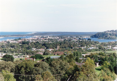
Photograph - Township, Tambo Shire, 1990c
Also second copy photographic enlargements of significant sites in the Tambo ShireColor photograph of the township, showing a distant view of the Ninety Mile Beach, the Gippsland Lakes and islands, Kalimna Heights, the bridge over the North Arm, Cunninghame Arm, and a broad view of the town and tree lined streets. Lakes Entrance Victoriabridges, topography, township, waterways -
 Falls Creek Historical Society
Document - Hand-Written - Re Sites 4 & 4a. (Almost Indecipherable)
Bob (Herman) Hymans (a former member of the Royal Netherlands Navy) was born in Bloemendaal, Holland on 30th September 1922. During World War II he fought against the Japanese in the Dutch East Indies (now Indonesia) and was imprisoned in Changi and on the Burma Railway. After gaining qualifications as a Ski Instructor, Bob arrived in Falls Creek in July 1950. Working as an Instructor and Supervisor at Bogong Lodge, Bob decided his future was in accommodation. He was successful in negotiating an indenture for land from the State Electricity Commission (SEC). It took Bob two years to build his Grand Coeur Chalet but, tragically, it was burned down in August 1961. Bob also built the first Chairlift in Australia. This was a single chairlift and the structure was built from wooden electricity poles. He was constantly full of new ideas and proposals for the village. Bob Hymans died on 7th July 2007. This Collection of documents and letters tells the story of Bob's endeavours to develop Falls Creek into the ski village it is today.This item is significant because it documents proposals put forward by Bob Hymans to develop facilities in the Falls Creek Tourist Area.A response from Mr. Hymans in response to the release of information related to the design of the extension to Christie Street in Falls Creek. As a result he wished to apply for a long-term lease of each site. I am in receipt of a letter from the General Superintendent Kiewa of the 3rd of April 1964. It was to inform me that the creation of new sites divided (?) with a 50’ ski road between them in trees of Site 4. Consequently, I wish to apply through your Committee for long term leases for the two sites. Yours faithfully H. Hymansfalls creek tourist area management committee, bob hymans, falls creek administration -
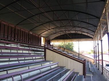
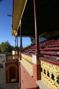
 Ballarat Heritage Services
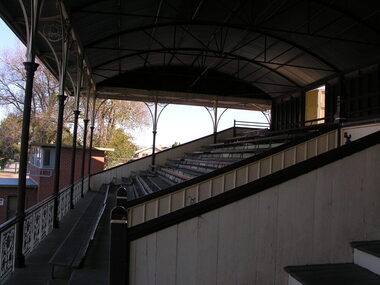
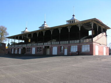
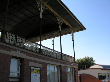
Photograph - Photograph - Colour, Dorothy Wickham, Cast Iron lace on the Grandstand at City Oval, Ballarat, c2015
Cricketer W.G. Grace said the City Oval was the 'most English' of any grounds he had played on in Australia. The City Ova Grandstand was constructed in 1898 to the designs of Clegg, Kell and Miller. The arched roof is supported by iron columns with cast iron brackets. Three squat lanterns are a feature of the roof, and support flagpoles. The cast iron balustrading at the front of the grandstand features a sunflower pattern, and the upper tiered section covers dressing rooms and internal stairways. Registered by Heritage Victoria, it is significant as a large and intact grandstand. The design, especially the roof, is unique in Victoria and the setting is enhanced by the ancillary ticket boxes and nearby mature trees. It was classifed by the National Trust on 11 June 1981. Colour photograph of the iron work at the Ballarat City Oval Grandstand.grandstand, ballarat city oval, cast iron, iron lace -
 Ballarat Heritage Services
Photograph - Photograph - Colour, Dorothy Wickham, Ballarat Coat of Arms of the City Oval Grandstand, Ballarat, 2017
Cricketer W.G. Grace said the City Oval was the 'most English' of any grounds he had played on in Australia. The City Ova Grandstand was constructed in 1898 to the designs of Clegg, Kell and Miller. The arched roof is supported by iron columns with cast iron brackets. Three squat lanterns are a feature of the roof, and support flagpoles. The cast iron balustrading at the front of the grandstand features a sunflower pattern, and the upper tiered section covers dressing rooms and internal stairways. Registered by Heritage Victoria, it is significant as a large and intact grandstand. The design, especially the roof, is unique in Victoria and the setting is enhanced by the ancillary ticket boxes and nearby mature trees. It was classifed by the National Trust on 11 June 1981. Colour photograph of the Ballarat Coat of Arms on the City Oval Grandstand, Ballarat. ballarat, ballarat coat of arms, city oval grandstand, grandstand -
 Ballarat Heritage Services
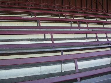
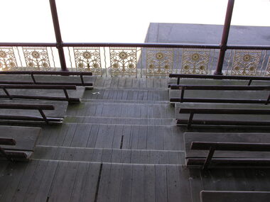
Photograph - Photograph - Colour, Dorothy Wickham, Seats at the City Oval Grandstand, Ballarat, c2015
Cricketer W.G. Grace said the City Oval was the 'most English' of any grounds he had played on in Australia. The City Ova Grandstand was constructed in 1898 to the designs of Clegg, Kell and Miller. The arched roof is supported by iron columns with cast iron brackets. Three squat lanterns are a feature of the roof, and support flagpoles. The cast iron balustrading at the front of the grandstand features a sunflower pattern, and the upper tiered section covers dressing rooms and internal stairways. Registered by Heritage Victoria, it is significant as a large and intact grandstand. The design, especially the roof, is unique in Victoria and the setting is enhanced by the ancillary ticket boxes and nearby mature trees. It was classifed by the National Trust on 11 June 1981. Colour photograph of the Ballarat City Oval grandstand.ballarat city oval, grandstand, cast iron -
 Ballarat Heritage Services
Photograph - Grandstand, L.J. Gervasoni, Ballarat City Oval Grandstand, c2014
Cricketer W.G. Grace said the City Oval was the 'most English' of any grounds he had played on in Australia. The City Ova Grandstand was constructed in 1898 to the designs of Clegg, Kell and Miller. The arched roof is supported by iron columns with cast iron brackets. Three squat lanterns are a feature of the roof, and support flagpoles. The cast iron balustrading at the front of the grandstand features a sunflower pattern, and the upper tiered section covers dressing rooms and internal stairways. Registered by Heritage Victoria, it is significant as a large and intact grandstand. The design, especially the roof, is unique in Victoria and the setting is enhanced by the ancillary ticket boxes and nearby mature trees. It was classifed by the National Trust on 11 June 1981. Colour photograph of the Ballarat City Oval Grandstandballarat, heritage, city oval, grandstand, cast iron, ballarat city oval -
 Ballarat Heritage Services
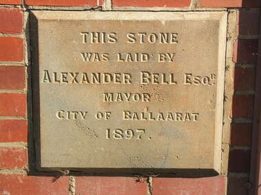
Photograph - Photograph - Colour, Dorothy Wickham, Foundation stone, Grandstand, City Oval, Ballarat
Cricketer W.G. Grace said the City Oval was the 'most English' of any grounds he had played on in Australia. The City Ova Grandstand was constructed in 1898 to the designs of Clegg, Kell and Miller. The arched roof is supported by iron columns with cast iron brackets. Three squat lanterns are a feature of the roof, and support flagpoles. The cast iron balustrading at the front of the grandstand features a sunflower pattern, and the upper tiered section covers dressing rooms and internal stairways. Registered by Heritage Victoria, it is significant as a large and intact grandstand. The design, especially the roof, is unique in Victoria and the setting is enhanced by the ancillary ticket boxes and nearby mature trees. It was classifed by the National Trust on 11 June 1981. Foundation stone at the City Oval grandstand.foundation stone, grandstand, city oval, ballarat, alexander bell -
 Ballarat Heritage Services
Photograph - Grandstand, Seats, Grandstand, City Oval, Ballarat, c2014
Cricketer W.G. Grace said the City Oval was the 'most English' of any grounds he had played on in Australia. The City Ova Grandstand was constructed in 1898 to the designs of Clegg, Kell and Miller. The arched roof is supported by iron columns with cast iron brackets. Three squat lanterns are a feature of the roof, and support flagpoles. The cast iron balustrading at the front of the grandstand features a sunflower pattern, and the upper tiered section covers dressing rooms and internal stairways. Registered by Heritage Victoria, it is significant as a large and intact grandstand. The design, especially the roof, is unique in Victoria and the setting is enhanced by the ancillary ticket boxes and nearby mature trees. It was classifed by the National Trust on 11 June 1981. Colour photograph of the grandstand at Ballarat City Oval. ballarat city oval, grandstand, seating -
 Ballarat Heritage Services
Grandstand, Seats, Grandstand, City Oval, Ballarat, c2014
Cricketer W.G. Grace said the City Oval was the 'most English' of any grounds he had played on in Australia. The City Ova Grandstand was constructed in 1898 to the designs of Clegg, Kell and Miller. The arched roof is supported by iron columns with cast iron brackets. Three squat lanterns are a feature of the roof, and support flagpoles. The cast iron balustrading at the front of the grandstand features a sunflower pattern, and the upper tiered section covers dressing rooms and internal stairways. Registered by Heritage Victoria, it is significant as a large and intact grandstand. The design, especially the roof, is unique in Victoria and the setting is enhanced by the ancillary ticket boxes and nearby mature trees. It was classifed by the National Trust on 11 June 1981. Colour photograph of the grandstand at Ballarat's City Oval. city oval, ballarat city oval, grandstand, seating -
 Ballarat Heritage Services
Photograph - Photograph - Colour, City Oval Grandstand, Ballarat, c2015
Cricketer W.G. Grace said the City Oval was the 'most English' of any grounds he had played on in Australia. The City Ova Grandstand was constructed in 1898 to the designs of Clegg, Kell and Miller. The arched roof is supported by iron columns with cast iron brackets. Three squat lanterns are a feature of the roof, and support flagpoles. The cast iron balustrading at the front of the grandstand features a sunflower pattern, and the upper tiered section covers dressing rooms and internal stairways. Registered by Heritage Victoria, it is significant as a large and intact grandstand. The design, especially the roof, is unique in Victoria and the setting is enhanced by the ancillary ticket boxes and nearby mature trees. It was classifed by the National Trust on 11 June 1981. Colour photograph of the grandstand at Ballarat City Oval. grandstand, ballarat city oval -
 Ballarat Heritage Services
Photograph - Photograph - Colour, Iron lace, Grandstand, City Oval, Ballarat, c2014
Cricketer W.G. Grace said the City Oval was the 'most English' of any grounds he had played on in Australia. The City Ova Grandstand was constructed in 1898 to the designs of Clegg, Kell and Miller. The arched roof is supported by iron columns with cast iron brackets. Three squat lanterns are a feature of the roof, and support flagpoles. The cast iron balustrading at the front of the grandstand features a sunflower pattern, and the upper tiered section covers dressing rooms and internal stairways. Registered by Heritage Victoria, it is significant as a large and intact grandstand. The design, especially the roof, is unique in Victoria and the setting is enhanced by the ancillary ticket boxes and nearby mature trees. It was classifed by the National Trust on 11 June 1981. Colour photograph of the Ballarat City Oval Grandstand. ballarat city oval, grandstand -
 Ballarat Heritage Services
Photograph - Grandstand, Iron lace, seats and floor, Grandstand, City Oval, Ballarat
Cricketer W.G. Grace said the City Oval was the 'most English' of any grounds he had played on in Australia. The City Ova Grandstand was constructed in 1898 to the designs of Clegg, Kell and Miller. The arched roof is supported by iron columns with cast iron brackets. Three squat lanterns are a feature of the roof, and support flagpoles. The cast iron balustrading at the front of the grandstand features a sunflower pattern, and the upper tiered section covers dressing rooms and internal stairways. Registered by Heritage Victoria, it is significant as a large and intact grandstand. The design, especially the roof, is unique in Victoria and the setting is enhanced by the ancillary ticket boxes and nearby mature trees. It was classifed by the National Trust on 11 June 1981. Colour photograph of the Iron lace, seats and floor at the City Oval grandstand, Ballaratcity oval ballarat, grandstand, iron, sun -
 The Beechworth Burke Museum
Photograph - Stereoscopic Photograph
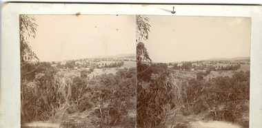
This photograph offers a view of Beechworth, located at the foot of the Victorian Alps. It captures the gorge and native vegetation in the foreground, with the Beechworth township visible in the middle, where the hospital is marked with an arrow. Distant hills form the backdrop. Originally settled c1839, Beechworth was officially proclaimed a town in 1856.This photograph is historically significant as it captures the landscape of Beechworth, providing valuable insight into the town's visual and historical character.Two sepia-toned square photographs showing the view of a town with trees in the foreground and hills in the far distance, mounted.Obervse: Above the right photograph there is an arrow pointing down. Reverse: 97.2195/ View across the Gorge/ looking over Beechworth/ (Hospital under arrow)/ 84-110-1/ A03082beechworth, town, landscape, ovens district, stereoscopic -
 Eltham District Historical Society Inc
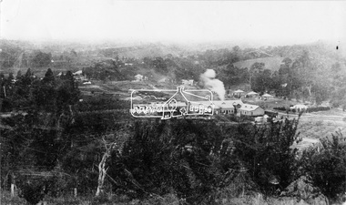
Negative - Photograph, Cool Stores, Hurstbridge, 1917
View overlookng Hurstbridge with the Cool Stores complex in the middle of the view (opened in March 1915) surrounded by an orchard of fruit trees. Local orchardists housed their fruits in cold storage here before despatch by rail to domestic and international markets, sometimes out of season.This photo forms part of a collection of photographs gathered by the Shire of Eltham for their centenary project book, "Pioneers and Painters: 100 years of the Shire of Eltham" by Alan Marshall (1971). The collection of over 500 images is held in partnership between Eltham District Historical Society and Yarra Plenty Regional Library (Eltham Library) and is now formally known as 'The Shire of Eltham Pioneers Photograph Collection.' It is significant in being the first community sourced collection representing the places and people of the Shire's first one hundred years.Digital image 4 x 5 inch B&W Negshire of eltham pioneers photograph collection, hurstbridge, cool stores, orchards, cool store -
 Lakes Entrance Historical Society
Photograph - Historic House, 2000
House built 1911 for James Carpenter as family home. Original front lawn of violets was venue for Violet Picking Days, around 1920 and 1930. Exterior now aluminium cladding. Occupied by Mac and Margo Kerby, pharmicists, 1960's to early 1980's. Ian Daniel 1990's. Name of house 'Corumbene' Also One Colour photograph of front fence. 02442.1Colour photograph of a substantial weatherboard triple fronted Californian Bungalow. Bull nose veranda returns around angle to side main decorative timber frieze under veranda roof. Two cypress trees and one Norfolk Island Pine of significant age. Situated at 90 Carpenter Street, Lakes Entrance.houses, heritage study -
 Falls Creek Historical Society
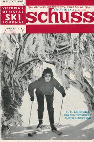
Journal - Schuss Vol. 26. No 7 September - October 1960
Schuss was advertised as Victoria’s Official Ski Journal It was issued monthly from 1935 to 1961 except during the war when summer issues covered two months. This continued after the war, but it averaged 10 issues annually over its 25 year life. Schuss was published by the Ski Club of Victoria which had a membership of 38 Ski Clubs and demanded to be recognised as the prime authority on skiing in the state. The other 30 ski clubs with 85% of the members disagreed and the politics of skiing became heated. These clubs formed the Federation of Victorian Ski Clubs with their own journal, Ski Horizon. With the establishment of the Victorian Ski Association, Ski-Horizon published its last issue in Nov - Dec. 1955 and the role of the official journal was fully taken over by “Schuss”. This item is significant because it contains stories, images and information documenting the development of the ski facilities at Falls Creek.The journal includes stories and events chronicling developments in Victoria and internationally. The cover features a photo of a female skier passing beneath trees, which was provided by the Herald newspaper. Pages 323 - 329 included an extensive report of the Australian National Ski Championships held at Falls Creek In August 1960, written by R. J. Zatorski. Results were included with this report. Fred Griffith contributed a report and results of the N.E.D.S.A. Junior Championships on pages 334 - 338. A selection of photos from both Championship events was included. Finally Falls Creek was able to boast of the existence of three electricity- powered street lights in the Village. After a long wait Skyline Lodge was also fully connected to electricity on 25th August 1960.schuss journal, skyline lodge, n.e.d.s.a. events at falls creek, national ski championships -
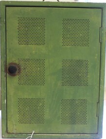 Wodonga & District Historical Society Inc
Domestic object - Meat Safe known as a "Coolgardie Safe", Early 1900s
The Coolgardie safe was invented in the late 1890s on the Western Australian goldfields. Its invention was credited to a local contractor named Arthur Patrick McCormick. It was a practical system to preserve food prior to modern refrigeration. The wire grid kept the food safe from vermin and allowed breeze to blow through. It was often covered with wet hessian so that as the breeze circulated the water evaporated, creating the same concept as coolant in modern refrigerators and ice boxes. In most respects it was a variation of the bushman’s hessian bag hanging in a tree. In larger towns and cities during this time period large "ice works" could deliver block ice to areas that required a form of refrigeration. These ice blocks where held in early refrigerators to keep perishables cool. In isolated or rural households, the Coolgardie or meat safe was the next best, practical solution for food preservation. This safe was used in the home of the Conway family in Wodonga.This item is very significant to the Wodonga region as it represents the initiative and problem solving skills of the early settlers. It also reflects the primitive conditions in which they lived before the arrival of more modern services such as electricity.Meat safe or Coolgardie safe manufactured in Australia. This safe is made from metal and has been painted in green paint. 2 sides of the safe have a pattern of 6 squares of holes to allow for ventilation and air flow. The holes would also guard against insects and other vermin. There is one shelf inside, dividing it into 2 sections. The safe has a hook attached so that it can be suspended, often from a tree or on a verandah to increase air flow. The safe would often be covered by wet hessian to promote further cooling and preservation of foods such as milk, butter and meat.coolgardie safe, food preservation, pioneers innovation -
 The Beechworth Burke Museum
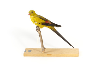
Animal specimen - Regent Parrot, Trustees of the Australian Museum, 1880-1860
This specimen is part of a collection of almost 200 animal specimens that were originally acquired as skins from various institutions across Australia, including the Australian Museum in Sydney and the National Museum of Victoria (known as Museums Victoria since 1983), as well as individuals such as amateur anthropologist Reynell Eveleigh Johns between 1860-1880. These skins were then mounted by members of the Burke Museum Committee and put-on display in the formal space of the Museum’s original exhibition hall where they continue to be on display. This display of taxidermy mounts initially served to instruct visitors to the Burke Museum of the natural world around them, today it serves as an insight into the collecting habits of the 19th century. The Regent Parrot has two separate populations separated by the Nullarbor Plain: one in the Mallee regions of eastern Australia, and the other in the Wheatbelt region of southern Western Australia. Though the populations are widely separated, the birds of each region do not appear especially different, one being a little duller than the other. There are, however, other differences between the two populations, especially in how they have fared: eastern populations are endangered, while the western population is thought to be increasing. The Regent Parrot eats seeds of grasses and plants and cereal crops, especially wheat. It also eats buds and flowers, insect larvae, psyllids and lerps. It forages in pairs or small parties, usually on the ground, but also in the canopy of trees or in spilled grain on the ground. The Regent parrot is endangered in NSW and Vulnerable in VIC This Particular specimen has been mounted correctly.This specimen is part of a significant and rare taxidermy mount collection in the Burke Museum. This collection is scientifically and culturally important for reminding us of how science continues to shape our understanding of the modern world. They demonstrate a capacity to hold evidence of how Australia’s fauna history existed in the past and are potentially important for future environmental research. This collection continues to be on display in the Museum and has become a key part to interpreting the collecting habits of the 19th century.A slim parrot with a long, dusky tapering tail and back-swept wings. It is mostly yellow, with blue-black wings and tail. There is a prominent yellow shoulder patch and red patches in the wings. The bill is deep pink. It is mounted on a thin wooden branch that is attached to a wooden mount with the scientific name located Label: T.L. 430MM / W.S. 540MM / WT. 200GMS / SEX [female symbol] Mount: Polytelis / Anthopeplus / Regent Parrot taxidermy mount, regent parrot, taxidermy, animalia, burke museum, bird, parrot -
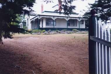
 City of Kingston
Photograph - Colour, Circa 1993
Edithvale is a suburb in the City of Kingston. It is located between Aspendale and Chelsea on the Port Phillip Bay and built within remnant areas of the Carrum Carrum swamp. The foreshore precinct comprises a wide sandy beach, with low sand dunes and numerous historic boat sheds. The suburb consists of older style dwellings and former holiday houses, combined with mid-century housing and newer homes. The large blocks are increasingly subdivided and the existing dwellings demolished to accommodate units and townhouses, thus changing the landscape of the area and reducing the tree canopy.The beachside suburb of Edithvale was previously part of the extensive Carrum Carrum Swamp. The area was once a source of fish and eels for the Mayone-Bulluk clan of the Bunurong people. Over time the area was drained and predominantly devoted to dairy farming and holiday houses. The farms were gradually sold and subdivided with a large number of homes built after World War II and in the 1960s. Edithvale is mainly residential with a shopping strip along Nepean Highway but little significant industry was ever established in the area apart from a plaster works and confectionary factory, both now closed.Aerial colour photograph of Edithvale as viewed from Alexandra Avenue in the north to Ella Grove Chelsea/Edithvale in the south. The area is built-up with residential housing and facilities including Edithvale Primary School, numerous churches and the Edithvale Railway station. Large sections depict the remnant Carrum Carrum swamp. Edithvale Common and the former "Duck Inn" (Melbourne Water/Friends of Edithvale Seaford Wetlands) can be seen. Edithvale Recreational reserve, the velodrome and Edithvale Public Golf Course are prominent. The image shows vacant land in the area now known as Aspendale Gardens and the newer residential section of Chelsea Heights is not developed. A bike path has been established to cover the secondary drain. The Golf Links Court residential development located off Hughes Avenue is a large vacant block.Yellow circular adhesive sticker on plastic Black ink (marker): * (asterisk) Black type on white adhesive sticker: P000108edithvale, aspendale, chelsea, carrum carrum swamp -
 Eltham District Historical Society Inc
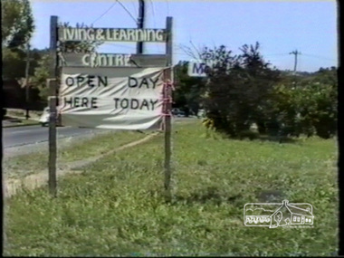
Film - Video (VHS), Open Day Eltham Living and Learning Centre, 1988
This cottage-like dwelling has changed ownership several times since it was first built in the 1850s by local tanner John Pearson. The Living and Learning Centre as we know it today is the product of the energetic, reforming era of the Whitlam Government. Set up by the local council in 1974. Unedited amateur video (filmed by Vivienne?) with some voiceover and chatting with others. Significant VHS tape noise/flicker and colour pulsing. Opens with Living & Learning Centre sign on Main Road and “Open Day Here Today” attached to it. Views of entrance into carpark, dog obedience class demonstration near entrance, leadlight construction display in workshop, basket weaving, face painting, exterior garden landscape with herb garden, brick pottery shed, peppercorn tree, children’s activities, interior views showing artworks of life drawings, general engagement with other people (audio), candle room, pottery, children’s entertainer in garden, wool spinning, some attempts at engagement with Claire Fitzpatrick, Thai Chi demonstration, floral presentations, patchwork, needlepoint, knitting, some interior scenes very dark, weaving, cane basket weaving.VHS Video cassette (poor quality) Converted to MP4 file format 00:31:39; 746MBeltham living and learning centre, open day, dog obedience class, leadlight, basket weaving, face painting, artworks, life drawing, candle room, pottery, wool spinning, claire fitzpatrick, thai chi, patchwork, needlepoint, knitting, weaving, cane basket weaving, main road, eltham, video recording, shire of eltham archives -
 Royal Australian and New Zealand College of Obstetricians & Gynaecologists (RANZCOG)
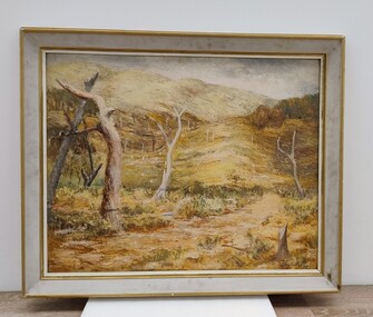
Painting, John 'Jack' Courier, Untitled (Landscape), 1965
It is likely this item was received from the estate of John 'Jack' Courier. Courier left a bequest to the College consisting of a significant number of artworks by himself and others.Untitled landscape painting. The painting depicts a series of dead tree trunks in a hilly landscape, with the suggestion of a path between the trees in the foreground. There are indistinct examples of trees with leaves in the middle background on the left and right of the painting. Lower right hand corner of painting is inscribed 'Courier/65'. The painting is housed in a white wooden frame with golden trim. The number '10', enclosed in a circle, is handwritten on the upper right hand corner of the back of the frame.'Courier/65'. -
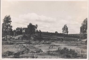
 Bendigo Historical Society Inc.
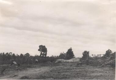
Photograph - Napoleon Reef Gold Mine Battery Site, 1936
The Napoleon (BML) gold mine (1932) was located beside McDougall Road, Golden Gully, between Martin and Hattam Street. It had a depth of 921 feet. It was one of the latest and most lavish of Bendigo's mines. Plant and equipment were electrically driven. The four-compartment shaft, extra large by goldfield's standards, measured 17 feet 6 inches by 5 feet 2 inches and was cement lined below 900 feet instead of being red gum boxed as was the usual practice. The workshop was equipped to carry out all repairs for the equally lavish BML mines on the Nell Gwynne and Carshalton reefs. (The Gold Mines of Bendigo, Book 2, Arthur Victor Palmer)Significant to mining history of Bendigo.Black and white photograph. Image shows flat, open landscape with four large eucalypt trees in centre of image. Four men working with shovels on left hand side of image, one man with wheelbarrow and dog alongside. Wooden framed structure on right hand side. Written in pencil on back of photograph: ' Battery excavations started 22/9/36' and 'excavations started'.napoleon gold mine, napoleon reef gold mine -
 Bendigo Historical Society Inc.
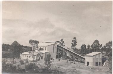
Photograph - Napoleon Mine Battery, 1936
The Napoleon (BML) gold mine (1932) was located beside McDougall Road, Golden Gully, between Martin and Hattam Street. It had a depth of 921 feet. It was one of the latest and most lavish of Bendigo's mines. Plant and equipment were electrically driven. The four-compartment shaft, extra large by goldfield's standards, measured 17 feet 6 inches by 5 feet 2 inches and was cement lined below 900 feet instead of being red gum boxed as was the usual practice. The workshop was equipped to carry out all repairs for the equally lavish BML mines on the Nell Gwynne and Carshalton reefs. (The Gold Mines of Bendigo, Book 2, Arthur Victor Palmer)Significant to mining history of Bendigo.Black and white photograph: landscape view of mine sheds. Battery shed fully completed with trestleway to another shed. Trees in background. Written in pencil on back of photograph: 'completed battery 5/12/36'napoleon gold mine, napoleon reef gold mine -
 Bendigo Historical Society Inc.
Photograph - Napoleon Gold Mine, 1935
Significant to mining history of Bendigo.Black and white photograph : Napoleon Gold Mine main shaft 1934. Image shows landscape view, some earth workings on site. Five men walking on different parts of site. Trees in background. Written in pencil on back of photograph in pencil: 'Napoleon main shaft site 23/8/34''napoleon gold mine -
Clunes Museum
Postcard - POSTCARD FROM THE ROCKS, HORNBY STUDIO
ONE SEPIA POSTCARD TITLED "CLUNES FROM ROCKS" IN WHITE HAND WRITING ON IMAGE. SIGNIFICANT BUILDINGS SHOWN ARE THE POST OFFICE , BANKS, SOME MATURE TREES AND MT BECKWORTH IN THE BACKGROUNDON BACK: DEAR ALLIE, AS I PROMISED YOU A VIEW OF CLUNES I AM SENDING YOU THIS ONE. HE IS SOLD OUT OF THE ONES WITH THE CREEK. i HOPE YOU ARE WELL. i REMAIN YOUR AFFECT COUSIN RANDAL STAMPED IWTH "POSTCARD" - CORRESPONDENCE AND KODAK AUSTRALIAclunes from the rocks, postcard