Showing 8789 items
matching south road
-
 Canterbury History Group
Photograph - Canterbury From Balwyn Hill, c1910
... View looking south down Balwyn Road, over Canterbury Road... and Wagons Horse Drawn Vehicles View looking south down Balwyn Road ...View looking south down Balwyn Road, over Canterbury Road to Logan Street and Cross Street. "Hazeldene" is on left, with a horse and cart waiting on the road. On the right is the old Baptist church. Now demolished and replaced by a new Baptist church.canterbury, canterbury gardens, canterbury road, logan street, cross street, balwyn road, hazeldene, baptist church, carts and wagons, horse drawn vehicles -
 Greensborough Historical Society
Article - Article, Book, Dianne Edwards, Turner Brothers Bakery, 1978
... on the Plenty Road at South Yan Yean (now Mernda)..., built in the 1880s on the Plenty Road at South Yan Yean (now ...Account of Turner Brothers bakery, built in the 1880s on the Plenty Road at South Yan Yean (now Mernda)1 p. text and photographyan yean, mernda, turners bakery, turner family -
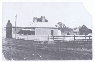
 Eltham District Historical Society Inc
Photograph - Aerial Photograph, Landata, Eltham, Feb. 1956
... by Leane Drive and Parsons Road to north, Nyora Road to south... by Leane Drive and Parsons Road to north, Nyora Road to south ...Centred on present day Shalbury Avenue, Eltham bounded by Leane Drive and Parsons Road to north, Nyora Road to south, Reynolds Road to east and the Diamond Creek to west Historic Aerial Imagery Source: Landata.vic.gov.au Aerial Photo Details: Project No :250 Project : MELBOURNE OUTER SUBURBS PROJECT Run : 18 Frame : 95 Date : 02/1956 Film Type : B/W Camera : EAG9 Flying Height : 10000 Scale : 12000 Film Number : 1176 GDA2020 : 37°41'57"S, 145°09'51"E MGA2020 : 338145, 5825965 (55) Melways : 22 C1 (ed. 42)aerial photo, 1956-02, neil webster collection, eltham, diamond creek (creek), melway 22c1, nyora road, parsons road, reynolds road, shalbury avenue -
 Eltham District Historical Society Inc
Photograph - Aerial Photograph, Landata, Eltham, Vic, Apr. 1972
... to south, Parsons Road to east and Banks Road to west. Historic... to south, Parsons Road to east and Banks Road to west. Historic ...Centred on present day Zig Zag Road near Coolabah Drive, Eltham bounded by Allendale Road to north, Park West Road to south, Parsons Road to east and Banks Road to west. Historic Aerial Imagery Source: Landata.vic.gov.au Aerial Photo Details: Project No :985 Project : MELBOURNE 1972 Run : 26 Frame : 191 Date : 04/1972 Film Type : B/W Camera : RC10 Flying Height : 5700 Scale : 9600 Film Number : 2636 GDA2020 : 37°41'56"S, 145°09'26"E MGA2020 : 337533, 5826000 (55) Melways : 22 A1 (ed. 42)aerial photo, neil webster collection, 1972-04, allendale road, eltham, eltham north, zig zag road, banks road, coolabah drive, melway 22a1, park west road, parsons road -
 Eltham District Historical Society Inc
Photograph - Aerial Photograph, Landata, Eltham, Vic, Apr. 1972
... Hughes Road to south, Eucalyptus Road to east and Susan Street... and Kent Hughes Road to south, Eucalyptus Road to east and Susan ...Centred on present day Dalton Street at Mount Pleasant Road, Eltham bounded by Arthur Street to north, Yarra River and Kent Hughes Road to south, Eucalyptus Road to east and Susan Street to west. Historic Aerial Imagery Source: Landata.vic.gov.au Aerial Photo Details: Project No :985 Project : MELBOURNE 1972 Run : 28 Frame : 208 Date : 04/1972 Film Type : B/W Camera : RC10 Flying Height : 5700 Scale : 9600 Film Number : 2635 GDA2020 : 37°43'29"S, 145°08'54"E MGA2020 : 336816, 5823118 (55) Melways : 21 J8 (ed. 42)aerial photo, neil webster collection, 1972-04, eltham, arthur street, dalton street, eucalyptus road, kent hughes road, melway 21j8, mount pleasant road, susan street, yarra river -
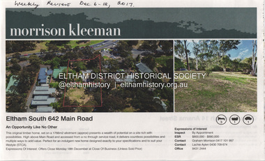 Eltham District Historical Society Inc
Document - Property Binder, 642 Main Road, Eltham
... , house 624 Main Road Eltham South...., house 624 Main Road Eltham South. Main Road Eltham Property ...Newspaper advertisement: Weekly Review, 6-12 December 2017, house 624 Main Road Eltham South.main road, eltham, property, houses -
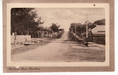 Whitehorse Historical Society Inc.
Postcard, Blackburn Road Blackburn circa 1914, 1914
... '. Scene shows Blackburn Road looking South from railway gates..., Blackburn'. Scene shows Blackburn Road looking South from railway ...Black and white postcard titled 'Blackburn Road, Blackburn'. Scene shows Blackburn Road looking South from railway gates. Shop on one corner. Unmade road.hooke, albert arthur, blackburn road, blackburn, janet emily -
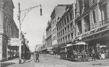 Melbourne Tram Museum
Photograph - Black and White photograph, c1900
... Malvern Road, looking south. Has an city bound cable tram... Prahran from near Malvern Road, looking south. Has an city bound ...Black and white photograph of Chapel St Prahran from near Malvern Road, looking south. Has an city bound cable tram in the photograph. Taken from a postcard.in ink in the corners "Postcard" and number 51326trams, tramways, cable trams, chapel st -
 Lakes Entrance Regional Historical Society (operating as Lakes Entrance History Centre & Museum)
Photograph, Edie Jemmeson, 1927 c
... Black and white photograph of Palmers Road looking south... Black and white photograph of Palmers Road looking south towards ...This photograph was used in the 150 year Lakes Entrance 1858 to 2008 display as the before picture paired with colour photograph number 03727.1 as the after picture size 10 x 15 cm road now paved with many buildings showingBlack and white photograph of Palmers Road looking south towards the sand dunes and ocean, teatree along the side of the road photographers shadow in foreground, Lakes Entrance Victoriatopography, sand dunes -
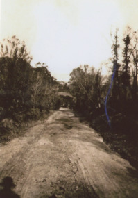
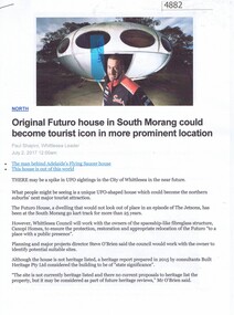 Greensborough Historical Society
Article - Website, Paul Shapiro, Original Futuro house in South Morang, by Paul Shapiro, 02/07/2017
... -Kart Track on McDonalds Road South Morang, where it is being..., and moved to the TUKE Go-Kart Track on McDonalds Road South Morang ...Of Finnish design, the building has been used as a sales booth at the Apollo Parkways estate, and moved to the TUKE Go-Kart Track on McDonalds Road South Morang, where it is being used as a storage building.3 p. text and col. and black and white photographs (digital reprint of original publication)futuro house, apollo parkways -
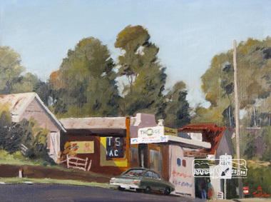 Eltham District Historical Society Inc
Photograph, Ted Dalton, The Corner Store, Ted Dalton, c.1980, 1980c
... View of the old Burgoyne store looking south-east across... melbourne View of the old Burgoyne store looking south-east across ...View of the old Burgoyne store looking south-east across Main Road, Eltham near the intersection with Bridge Street.Digital scan of painting c.1980 oil on board 44.5 x 59.5 cm signed lower rightburgoyne store, eltham, main road, ted dalton -
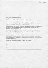 Whitehorse Historical Society Inc.
Document, Box Hill Aged Men's Retreat
... Middleborough Road Blackburn South No. 220...The Salvation Army purchased 220 Middleborough Road... Road, Blackburn South in 1919 and established the Box Hill Aged ...The history of the Box Hill Aged Men's RetreatA document outlining the history of the Box Hill Aged Men's Retreat which became Inala Villagenon-fictionThe history of the Box Hill Aged Men's Retreatbox hill aged men's retreat, inala village, salvation army, middleborough road blackburn south no. 220 -
Whitehorse Historical Society Inc.
Article, Childcare Centre crush, 2016
... centre in Holland Road Blackburn South are lobbying council... Holland Road Blackburn South Child Care centres Neighbours ...Neighbours of a proposed two-storey, 118-place childcare centre in Holland Road Blackburn South.Neighbours of a proposed two-storey, 118-place childcare centre in Holland Road Blackburn South are lobbying council to have it rejected due to the chaotic traffic conditions and lack of parking.Neighbours of a proposed two-storey, 118-place childcare centre in Holland Road Blackburn South.city of whitehorse, holland road, blackburn south, child care centres -
 Whitehorse Historical Society Inc.
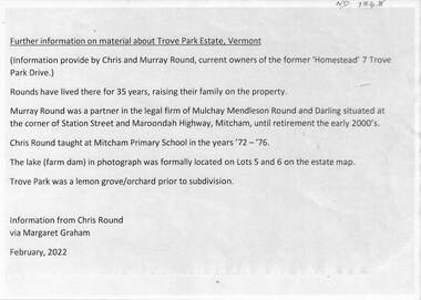
Document - Real estate notes, maps, flyers, Trove Park Estate, 1969, 2022
... road (east) and Jolimont Road (south)... road (east) and Jolimont Road (south) A history of the Trove ...A history of the Trove Park Estate, Vermont from 1880's to 2022 is provided by notes, maps, pictures and auction flyers. The Estate was originally part of the Uplands Estate of 34 acres in the Mount Pleasant district.A history of the Trove Park Estate, Vermont from 1880's to 2022 is provided by notes, maps, pictures and auction flyers. The Estate was originally part of the Uplands Estate of 34 acres in the Mount Pleasant district.A history of the Trove Park Estate, Vermont from 1880's to 2022 is provided by notes, maps, pictures and auction flyers. The Estate was originally part of the Uplands Estate of 34 acres in the Mount Pleasant district.trove park drive estate vermont, mt pleasant, trove park, uplands vermont, bishop edward, round chris & murray, mulcahy mendelson & round, trove park drive vermont no 7 -
Whitehorse Historical Society Inc.
Map, Melbourne Metropolitan Area Base Map, 1957?
... , creeks and contours mostly south of Canterbury Road. Prep. from..., creeks and contours mostly south of Canterbury Road. Sheet 254 ...Sheet 254 of part of the Municipality of Nunawading and part of the Parish of Nunawading, showing roads, block numbers, creeks and contours mostly south of Canterbury Road.Sheet 254 of part of the Municipality of Nunawading and part of the Parish of Nunawading, showing roads, block numbers, creeks and contours mostly south of Canterbury Road. Prep. from State Aerial and Cadastral survey information, August 1957. Scale: 400 ft = 1 inchSheet 254 of part of the Municipality of Nunawading and part of the Parish of Nunawading, showing roads, block numbers, creeks and contours mostly south of Canterbury Road. city of nunawading, cadastral -
Whitehorse Historical Society Inc.
Document, John McClare, n.d
... a selection on the south side of Canterbury Road.... Madden took a selection on the south side of Canterbury Road.... a selection on the south side of Canterbury Road. John McClare ...Potted history of John and Mary McClare, arrived in Melbourne 1855 from Galway, Ireland.Potted history of John and Mary McClare, arrived in Melbourne 1855 from Galway, Ireland. Bought 55 acres on Canterbury Road. He paid 4 ponds per acre. he carried goods to the goldfields with his bullock team. Later he had a tannery and leather business on Canterbury Road. Their 1st child, Agnes was first white child born in the district. in 1862 John brought out his wife's brother and 2 sisters. Katherine and John Madden. John Madden took a selection on the south side of Canterbury Road.Potted history of John and Mary McClare, arrived in Melbourne 1855 from Galway, Ireland. mcclare, john, bowen, michael, mcclare, mary, mcclare, agnes, mcclare james, mcclare, rose, madden, katherine, madden, john, delaney's road, canterbury road, vermont, vermont -
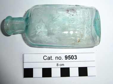 Coal Creek Community Park & Museum
Bottle, glass, c.1908 - c.1938
... , made by Crown Chemical Co. City Road, South Melbourne'. source... Cordial Extract, made by Crown Chemical Co. City Road, South ...Border Watch (Mt. Gambier South Australia) newspaper, Advertisement. Tuesday 6 January 1925, page 4, 'Iona Cordial Extract, made by Crown Chemical Co. City Road, South Melbourne'. source Trove.Pale aqua tinted clear glass bottle, ellipse shaped in cross section, embossed text on one side and monogram on base. Slightly asymmetrical, glass surface has some oxidisation (may have been buried or burnt).'TRADE MARK IONA CROWN CHEMICAL CO MELB' on side. AGM monogram on basecordial -
Port Melbourne Historical & Preservation Society
Document - Lagoon Confectioners List and Prices of Manufactured LInes, c.1950
... Albert Road, South Melbourne. These included Boiled Sweets... Confectioners commenced manufacturing in 1921 at 118 Albert Road, South ...Lagoon Confectioners commenced manufacturing in 1921 at 118 Albert Road, South Melbourne. These included Boiled Sweets, Chocolate Novelties Counted Lines and1/2d Novelties. In 1970 they moved to premises in Graham Street, Port Melbourne. Small folded pale green pamphlet listing Lagoon Confectioners range of products and prices.lagoon confectionery pty ltd, industry - manufacturing -
 Whitehorse Historical Society Inc.
Photograph, Horse Trough
... of Canterbury and Blackburn Roads Blackburn South. This trough was one... Roads Blackburn South. This trough was one of many donated ...Water troughs were installed to provide relief for working horses in the first half of the 20th century. As the use of motorised transport increased the use for water troughs declined.Coloured photograph of a horse trough located on the corner of Canterbury and Blackburn Roads Blackburn South. This trough was one of many donated by Annis and George Bills. See ND883 and ND885 for articles in the 'Sun'.horse troughs bills george and annis -
 Whitehorse Historical Society Inc.
Photograph, Whitehorse Road, Mitcham
... Black and white photograph of the shops on the south side...Whitehorse Historical Society Inc. 2-10 Deep Creek Road ...Black and white photograph of the shops on the south side of Whitehorse Road, Mitcham in the 1940's. Frock shop on the right of photo (See also Post office and State Savings Bank for Landmarks)whitehorse road, mitcham c1940's, roads and streets -
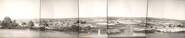 Federation University Historical Collection
Photograph (Black & White), Keith E. Rash, Ballarat From Sovereign Hill Looking East, 1951
... Sovereign Hill and look towards the South East. Geelong Road.... The Photos were taken from Sovereign Hill and look towards the South ...Keith Rash was highly involved in research relating to Ballarat. He took this photo in the Gold centenary year.Six small black and white photographs have been taped together to form a panorama of Ballarat. The Photos were taken from Sovereign Hill and look towards the South East. Geelong Road is evident in the foreground. In the centre of the panorama is Mt Warrenheip, and to the right is Mt Buninyong. Stamped lower right 'K.E.Rash'ballarat, sovereign hill, ballarat east, keith rash, mount buninyong, mount warrenheip -
Whitehorse Historical Society Inc.
Document, Notes on the poultry industry
... Interview with T.H. (Harry) Pettigrove, Fulton Road, South... with T.H. (Harry) Pettigrove, Fulton Road, South Blackburn. He ...Interview with T.H. (Harry) Pettigrove, Fulton Road, South Blackburn. He closed his hatchery in Blackburn in 1975 and moved to Somerville.Interview with T.H. (Harry) Pettigrove, Fulton Road, South Blackburn. He closed his hatchery in Blackburn in 1975 and moved to Somerville. He transferred the business to Somerville and then his son continued with the business. He describes the operations of the poultry industry in the 1930's and 1940's.Interview with T.H. (Harry) Pettigrove, Fulton Road, South Blackburn. He closed his hatchery in Blackburn in 1975 and moved to Somerville. poultry farms, pettigrove, t.h., harry -
 Whitehorse Historical Society Inc.
Photograph, Michael McDonnell and Family, c1925
... outside their family home in Whitehorse Road (south side, four... home in Whitehorse Road (south side, four blocks from Rooks ...Black and white photo of Michael McDonnell and his family outside their family home in Whitehorse Road (south side, four blocks from Rooks Road.) c1925. Molly (mother) and Michael and their four children - Leo, Eileen, Jack and Frank in front .|Original on CD ROMmcdonnell, family, michael, molly -
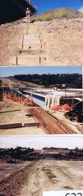 Greensborough Historical Society
Photographs, Gary Partington, Greensborough By-Pass, 1986_
... in the south to Diamond Creek Road in the north. It is intersected... from Grimshaw Street in the south to Diamond Creek Road ...The Greensborough by-pass extends from Grimshaw Street in the south to Diamond Creek Road in the north. It is intersected by the eastern end of the Metropolitan Ring Road.Unpublished photographs of the construction of the Greensborough by-pass.21 colour photographs of the construction phase of the Greensborough By-pass.greensborough bypass, roads, greensborough, gary partington, metropolitan ring road -
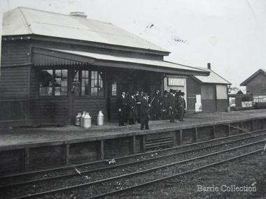 Melton City Libraries
Photograph, Melton Train Station, Unknown
... The Melton South Railway Station, Brooklyn Road Originally... The Melton South Railway Station, Brooklyn Road Originally built ...The Melton South Railway Station, Brooklyn Road Originally built in the town of Leeor in 1898, the station building was relocated to Melton South in 1898. Black and white image of Melton Train Stationtransport, local architecture -
 Kew Historical Society Inc
Photograph - Kew Junction, Herald & Weekly Times, 1962
... the intersection of High Street South, Studley Park Road, Princess Street..., showing the intersection of High Street South, Studley Park Road ...This is an aerial oblique image looking north. It shows Kew Junction before construction of VicRoads (Country Roads Board), Murphy's (Leo's) supermarket, and office towers. It also shows a building on the land now known as the Raoul Wallenberg Reserve, the Kew Municipal Offices in Walpole Street, and St Paul's School for the Blind in Fernhurst Grove, and Kew Bowling Club in Wellington Street.An aerial photograph of Kew Junction, showing the intersection of High Street South, Studley Park Road, Princess Street, High Street and Denmark Street. A number of buildings, now demolished can be identified in the photo, including Jellis’ Bakeries on the corner of Princess Street and Studley Park Road." Annotation on reverse: "Kew Historical Society from Mr L. H. Chinner".kew junction, aerial photograph (kew), oblique aerial, st paul's school for the blind, kew municipal offices, high street kew, studley park road, kew war memorial, kew post office, kew police station, kew court house, high street south, kew, wellington street kew, denmark street kew -
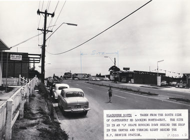 Whitehorse Historical Society Inc.
Photograph, Site of Blackburn Fibrous Plaster Works, 9/11/1962 12:00:00 AM
... Works, Canterbury Road, Blackburn South. On left hand side can... Plaster Works, Canterbury Road, Blackburn South. On left hand side ...The Blackburn South Post Office was in 1962 housed in a building originally built as a P.O. for the 1956 Olympics games. It was located in the grounds of the M.C.C. and was transported to the Blackburn South site. Demolished c1970s. Information supplied by Stan Hander, 34Drummond Street, Blackburn South. He worked near the P.O. during the Olympics.Black and white photo of site of Blackburn Fibrous Plaster Works, Canterbury Road, Blackburn South. On left hand side can be seen the Blackburn South Post Office ( see History below).blackburn fibrous plaster works, blackburn south post office., hander, stan, olympic games -
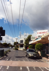 Whitehorse Historical Society Inc.
Photograph, Mitcham North Shopping Centre, 2006
... Park Road) looking south. Communications towers situated... Park Road) looking south. Communications towers situated ...Coloured Photo of Mitcham North Shopping Centre (opposite Park Road) looking south. Communications towers situated on roof of a security service building. Land surveyor and chemist on right (west side ).mitcham north shopping centre, shops, shopping centre -
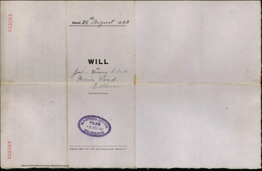 Eltham District Historical Society Inc
Document - Will, J.H. Clark, John Henry Clark, Main Road, Eltham, 25 Aug 1953
... and bootmaker of Main Road, Eltham South. Appointed Executor John... and bootmaker of Main Road, Eltham South. Appointed Executor John ...Last will and testament of John Henry Clark, photographer and bootmaker of Main Road, Eltham South. Appointed Executor John Francis Carrucan of Dalton Street, Eltham.bootmakers, j.h. clark photo, john francis carrucan, john henry clark, photographer, probate, prov, will -
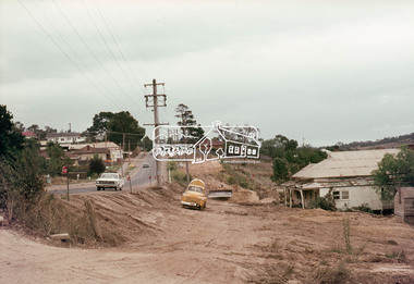 Eltham District Historical Society Inc
Photograph, Main Road widening, Eltham, c.March 1968, 1968
... Immediately prior to duplication of Main Road. Looking... melbourne Immediately prior to duplication of Main Road. Looking ...Immediately prior to duplication of Main Road. Looking south from Eltham Shire offices. Remains of old Gahan house on right just prior to demolition35mm Colour positive transparency Mount - Agfacolor Service (Blue stepped)duplication, eltham, gahan house, main road