Showing 171449 items
matching streets
-
 Marysville & District Historical Society
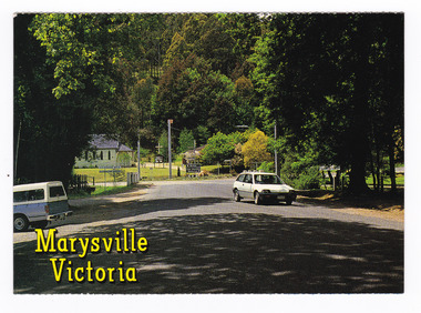
Postcard (item) - Colour postcard, Nucolorvue Productions Pty. Ltd, Marysville Victoria-The picturesque main street, Pre 2009
A colour photograph of the tree lined main street in Marysville in Victoria.A colour photograph of the tree lined main street in Marysville in Victoria. The main street is Murchison Street. This postcard was produced by Nucolor Productions Pty. Ltd. as a souvenir of Marysville.MARYSVILLE VICTORIA/ The picturesque main street. NU-COLOR-VUE/ AUSTRALIA'S NATIONAL POSTCARD COMPANY AFFIX/ STAMP/ HERE/ 11MA015/ NCV 7957 ADDRESS/ POSTCODE COPYRIGHT Nucolorvue Productions Pty. Ltd./ Telephone (03) 560-1788/ Made in Australiamarysville, main street, murchison street, victoria, nucolorvue productions, postcard, souvenir -
 Marysville & District Historical Society
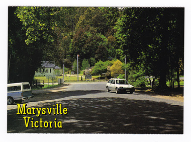
Postcard (item) - Colour postcard, Nucolorvue Productions Pty. Ltd, Marysville Victoria-The picturesque main street, Pre 2009
A colour photograph of the tree lined main street in Marysville in Victoria.A colour photograph of the tree lined main street in Marysville in Victoria. The main street is Murchison Street. This postcard was produced by Nucolor Productions Pty. Ltd. as a souvenir of Marysville.MARYSVILLE VICTORIA/ The picturesque main street. NU-COLOR-VUE/ AUSTRALIA'S NATIONAL POSTCARD COMPANY AFFIX/ STAMP/ HERE/ 11MA015/ NCV 7957 ADDRESS/ POSTCODE COPYRIGHT Nucolorvue Productions Pty. Ltd./ Telephone (03) 560-1788/ Made in Australiamarysville, main street, murchison street, victoria, nucolorvue productions, postcard, souvenir -
 Bendigo Historical Society Inc.
Slide - No 5 Michelsen Street North Bendigo Early Cottage
The Bendigo & Region Branch is the National Trust’s voice in the region. The Branch works with council and the community on local heritage issues. New members are always welcome at any of the Branch’s meetings and events.No 5 Michelsen Street North Bendigo Early Cottage - SlideNo 5 Michelsen Street is now a block of units.history, bendigo, national trust collection bendigo, 5 michelsen street north bendigo -
 Northern District School of Nursing. Managed by Bendigo Historical Society Inc.
Photograph - Nursing staff "Eurella"
The Northern District School of Nursing opened in 1950 in to address the issues around nurse recruitment, training and education that had previously been hospital based. The residential school was to provide theoretical and in-house education and practical training over three years. The students would also receive practical hands-on training in the wards of associated hospitals. The Northern District School of Nursing operated from Lister House, Rowan Street, Bendigo. It was the first independent school of nursing in Victoria and continued until it closed in 1989.Three (unnamed) off duty nurses relax on the cast-iron lace verandah of "Eurella", the NDSN school's first hostel, View StreetOff duty nurses relax find time for a chat on the cast-iron lace verandah of "Eurella", the NDSN school's first hostel, View Street (late 1950s). Opposite Barkly Street.ndsn, nursing, uniforms -
 Kew Historical Society Inc
Slide - Former Livery Stables, Walpole Street, 1980
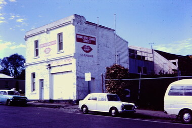
One of a group of slides taken by Mrs C Dickins, the mother of Joy Stewart, of built heritage in Kew. 35mm colour transparency (slide) of a rendered brick commercial building at 6 Walpole Street, Kew, taken in 1980 (now demolished). The double-fronted, two-storey building has a street frontage. Behind the formal rendered front, there is a wooden rear section then an extensive building with a pitched roof made of what appears to be galvanised iron sheeting. The ground floor facing Walpole Street includes a window and door on the left and a wide opening on the right to allow vehicular access; and earlier access by horses and carts when it was a livery stable. The second floor has two sash windows. Painted advertising signage includes: Brown's Office Cleaning Service, and Coakley Motors which would indicate the probable tenancy of the building at this or an earlier period. The building was located across the street from the (former) Kew Library and (former) Kew Town Hall. "Walpole Street"coakley motors -- kew (vic.), livery stables -- kew (vic.), walpole street -- kew (vic.) -
 Glenelg Shire Council Cultural Collection
Negative - Glass Plate Negative - Bentinck Street and Railway Station Portland, 1890-1910
Glass plate negative. Image shows Bentinck Street and Railway Station looking north from Post Office balcony, shows Gordon Hotel without its portico and on the north corner of Julia Street and the Bank of Australasia.Front: 'Bentinck Street Portland' - green -
 Kew Historical Society Inc
Photograph - High Street, Kew East
In 1980, Mr Laurie Bennett presented the Kew Historical Society with a number of photographs and postcards from the estate of his mother Eileen Mary Bennett (nee Clark). His mother was the daughter of Lawrence FH Clark(?-1946) and Mary Clark (?-1925) of 22 Harp Road, East Kew, in whose yard the photograph was taken. A year before the donation occurred a notice appeared in the Canberra Times stating that: "BENNETT, Eileen Mary. — May 8th at Tuross Heads, N.S.W. Late of 22 Harp Rd, East Kew, (Vic). Dearly loved wife of the late Harold Bennett, loved mother and mother in law of Laurie and Shirley (Melbourne), Kevin and Doreen (Canberra), grandmother of Linda, Stephen, Paul, Gabrielle, Peter, Mark and Jon."Part of a large collection of photographs and postcards in the collection. This dated photograph allows the researcher to identify development by 1916 in Kew and East Kew.High Street, Kew East in 1916 looking west. "High Street, East kew, near rail bridge."laurie bennett, eileen mary bennett, eileen mary clark -
 Lakes Entrance Historical Society
Postcard - Main Street Bairnsdale, Bulmer, 1920 to 1930 c
Black and white postcard showing Main Street Bairnsdale taken from the water tower Bairnsdale VictoriaMain Street Reserves Bairnsdaletownships, roads and streets -
 Northern District School of Nursing. Managed by Bendigo Historical Society Inc.
Photograph - NDSN Hostel/office block
The Northern District School of Nursing opened in 1950 in to address the issues around nurse recruitment, training and education that had previously been hospital based. The residential school was to provide theoretical and in-house education and practical training over three years. The students would also receive practical hands-on training in the wards of associated hospitals. The Northern District School of Nursing operated from Lister House, Rowan Street, Bendigo. It was the first independent school of nursing in Victoria and continued until it closed in 1989.Coloured photograph shows view of NDSN Lister House Short Street hostel and new office block; 1966, across to Greater Bendigo.1966 / Short Street Hostel/ New Office Block/ from Faye Stauchndsn, nursing -
Tatura Irrigation & Wartime Camps Museum
Photograph - copy, Boomerang Cafe in Hogan Street Tatura, 1930
Small duplicate of photograph, also cataloged L0110 Black and white photograph of Boomerang cafe in Hogan Street, Tatura, 19301930 Boomerang Cafe Hogan Street, Tatura.nell myers, sarah colliver, boomerang cafe tatura, n. lenehan -
 Sunbury Family History and Heritage Society Inc.
Photograph, Frank Breen, Macedon Street-100 years ago, c1990
The mural of an impression of Macedon Street in Sunbury 100 years ago was painted by Frank Breen, on the brick garage wall of the Catholic Presbytery and it faced the garden in front of the former Sunbury Courthouse. Before the railway arrived in Sunbury in 1859, Macedon Street was the town's business centre. Early local businesses and and institutions that the artist included in the mural include on the LHS former courthouse, Out Lady of Mt. Carmel and the Sir John Franklin Hotel. On the RHS are some shops and the Ballcourt Hotel.The mural gives an impression of Sunbury's first business centre before it shifted closer to the railway station which arrived in Sunbury in 1859.A non-digital coloured photograph of an artist's impression of a street in Sunbury 100 years ago. The photograph has been encased in a cream card with an inscription on the back. 'MACEDON STREET 100 YEARS AGO'/ARTIST: FRANK BREEN/OLD SUNBURY COURTHOUSE/ SUNBURY, VICTORIA, AUSTRALIAmurals, macedon street, frank breen, sunbury courthouse, our lady of mount carmel, hotels -
Tatura Irrigation & Wartime Camps Museum
Photograph, Clock Tower Tatura, 1950
Photogrpah of memorial clock tower, built 1940 in memory of Dr J. Park. Money raised by public subscription, built by W. J. Montgomery. Cost - clock tower 168 pounds 15 shillings; electric clock 34 pounds 5 shillings.Black and white photograph of clock tower, Hogan Street, Tatura.on back: Clock Tower Hogan Street Tatura 1950dr j. park, monuments tatura -
 Surrey Hills Historical Society Collection
Compact disc, Victorian Directory 1916-1920 (Sands & McDougall) (5 discs)
... streets ...The Sands and McDougall directories are amongst the most comprehensive. You can find out more details about places in which people lived, the other residents in the area, the services available in the region...all of which help to paint a picture of your ancestors' life. Apart from the Street,Alphabetical, Trade and Professional directories, this volume also contains Government and Official, Ecclesiastical, Legal, Municipal, Colonial, Societies and Institutions directories. This compendium of Sands and McDougall's directories covers 1916-1920. Each is very comprehensive containing the following sub-directories: city streets Directory: with a street index, and street by street listings of all houses and the householder at each address. Country directory: that lists people alphabetically for each town and their occupation. Alphabetical Directory: covering the whole of Victoria. Melbourne and Suburban Professional & Trade Directory: listing people by their trade. Country Professional & Trade Directory: complements the Melbourne list to give coverage of all Victoria. It also includes Agriculture and Pastoral; Government and Official; Legal and Judicial including Justices of the Peace; Ecclesiastical.The Sands and McDougall directories are amongst the most comprehensive. You can find out more details about places in which people lived, the other residents in the area, the services available in the region...all of which help to paint a picture of your ancestors' life. Apart from the Street,Alphabetical, Trade and Professional directories, this volume also contains Government and Official, Ecclesiastical, Legal, Municipal, Colonial, Societies and Institutions directories. This compendium of Sands and McDougall's directories covers 1916-1920. Each is very comprehensive containing the following sub-directories: city streets Directory: with a street index, and street by street listings of all houses and the householder at each address. Country directory: that lists people alphabetically for each town and their occupation. Alphabetical Directory: covering the whole of Victoria. Melbourne and Suburban Professional & Trade Directory: listing people by their trade. Country Professional & Trade Directory: complements the Melbourne list to give coverage of all Victoria. It also includes Agriculture and Pastoral; Government and Official; Legal and Judicial including Justices of the Peace; Ecclesiastical.streets, trade, agriculture, government, legal, ecclesiastical, farmers, farm workers, clergy -
 Port Fairy Historical Society Museum and Archives
Photograph
Moyne river bridge photograph taken in 1956 showing Blakes caravan park in backgroundColoured landscape of the Moyne River bridge taken from the balcony of the house (Riverside) on the corner of Regent Street and Gipps street From Tom Bartlett's Gipps Street looking East over bridge 1956bridge, moyne river, traffic, gipps street -
 Orbost & District Historical Society
Photograph - Opening of Orbost Museum
This is a photograph of Mr & Mrs Peter Nixon about to board Kaye Lynn's covered jinker which is pulled by a horse to travel to open the Orbost Historical Society's Museum in Nicholson Street, Orbost. The original location of the Museum 1967 was in the building which is now (2022) used by the Cricket Club & Senior Citizens. The Library was also located there. Since 1994 and following the Orbost Shire's amalgamation into East Gippsland, the Library and Museum were located into the Shire's Business Centre in Ruskin Street, Orbost.photograph of an event in Orbost A b/w photograph of large car on the right hand side, two people in the centre, and a horse and sulky on the left. They are in a street.On back: Mr and Mrs Nixon are about to board Kaye Lynn's covered jinker to travel to open Orbost Historical Museum in Nicholson Street, Orbost. peter nixon mp, orbost museum, kaye lynn -
 City of Kingston
Pamphlet - Colour, Duffus Bros, Railway Reserve Highett, c. 1923
Sales plan for land in the suburb of Highett, titled Railway Reserve, incorporating properties along Wolseley Street, Livingston Street, Highett Road and Worthing Road. The developing urban area of Highett within the City of Kingston. This land sale pamphlet illustrates the subdivision of land within the municipality and the changing demographic of the district as new houses and shops are constructed close to infrastructure.Colour pamphlet advertising thirty eight shop and villa sites for sale at the Railway Reserve, Highett. Incorporates a map of the reserve with properties available on Wolseley Street, Livingston Street, Highett Road and Worthing Road. Handwritten in grey pencil: assumed sale price recorded on subdivisions 1-7, 10, 22, 23 and 34 Handwritten in grey pencil on subdivision 4: C. Nevill / City of Melbourne bank Handwritten in grey pencil across subdivision 7: 49' Handwritten in grey pencil across subdivision 21 and 22: 134' Handwritten in grey pencil across subdivision 25 and 26: 200' Handwritten in grey pencil across subdivision 36 and 37 and both top and bottom: 120' Hand drawn in blue pencil: outline of subdivision 4 Hand drawn in blue pencil: outline of subdivisions 7, 23, 28, 37, 38 along left hand side, subdivisions 38, 37 and 36 on Wolseley Street, subdivisions 30 and 29 along Wolseley Street, subdivisions 29 and 24 along the middle of the plan, subdivisions 24 and half of 25 along Livingston Street, half of subdivision 20 along the middle of the plan, subdivisions 21 and 22 along the Right of Way between Livingston Street and Highett Road, and along the right hand border of subdivision 7. Handwritten in ink adjacent to the subdivision plan, updside down, in the bottom right hand corner: 276 / 54 / 280 / 45 / 320 / 202 / 200 / 134 / horizontal line / 11/14 Handwritten in ink adjacent to the subdivision plan, updside down, in the bottom right hand corner: 1714)2200(15 / 1714 / horizontal line / 486land sales, highett -
 City of Kingston
Pamphlet - Colour, S. M. Reynolds, Estate Agent, Moorabbin Shire Hall Estate Second Section, c. 1930
Sales plan for land in the suburb of Moorabbin, bounded by South Road and Highbury Street, including Prince Street, Charming Street, Thomas Avenue and Keith Road.The developing urban area of Moorabbin within the City of Kingston. This land sale pamphlet illustrates the subdivision of land within the municipality and the changing demographic of the district as new houses are constructed close to infrastructure.Colour pamphlet advertising for private sale the Moorabbin Shire Hall Estate, Moorabbin. Incorporates a map of the estate bordered by South Road and Highbury Street, including Prince Street, Charming Street, Keith Road and Thomas Avenue.Handwritten in grey pencil on subdivision map below subdivision 63: £4 Handwritten in grey pencil on subdivision map below subdivision 66: 4 Handwritten in grey pencil on subdivision map below subdivision 80: 3. Handwritten in grey pencil on subdivision map below subdivision 81: 4 Handwritten in grey pencil on subdivision map below subdivision 83: 2 Handwritten in grey pencil on subdivision map below subdivision 96: £3 Handwritten in grey pencil on subdivision map below subdivision 97: 3 Handwritten in grey pencil on subdivision map to the left of subdivision 102: 3 Handwritten in grey pencil on subdivision map on the corner of Thomas Avenue and Highbury Street: vertical line next to a square with a cross in it.land sales, estate, moorabbin -
 Kew Historical Society Inc
Photograph, High Street (Kew), circa 1900, c. 1900
Small inscribed (later) copy of High Street from Kew Junction"High Street Looking Up From Kew Junction"high street - kew (vic), bulleen road - kew (vic) -
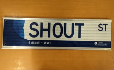 City of Whittlesea
Sign (item) - Street Sign, Shout St - Gallipoli WW1 street sign
Provided to History Collection due to being an additional/spare production item.Commemorative for ANZAC Centenary 2014-2018 - Serving Victoria's Stories & Making Connections. Gallipoli WW1; Shout Streetstreet sign -
 Kew Historical Society Inc
Photograph, Stuart Tompkins Studio, Electricity Supply Poles, Warrigal Road, Ashwood, 1965
Research provided by Stuart Tompkins Studio, Box Hill, into alternatives for median strip street lighting to be used in Burke Road, Kew. The photographers identified variants in different suburbs appropriate to Kew's needs.The series from which the photograph is drawn provides a snapshot by a commercial photographic studio of each named vicinity in 1965 as well as providing examples of public works infrastructure being commissioned by local government in the 1960s. The photos originally formed part of the Engineering Department's files in the City of Kew before being donated to the kew Historical Society.Electricity Supply Poles, Warrigal Road, Ashwood, 1965. Stuart Tompkins Studio provided this photograph for the Kew City Council. The photograph, taken at the intersection of Warrigal Road and High Street South, Ashwood looks north along High Street Road. The intent of the photograph was to provide the Council with models of electricity supply poles. In the photo, wooden and steel poles can be seen in the median strip. The photograph also includes the shops bordering High Street Road during this period. [There are three copies of this photograph in the Collection.]. Typed inscription on reverse: "Electricity Supply Poles. Photographed for Kew City Council 8/2/65. No.4 Warrigal Road - Ashwood. South of High Street Road looking north. Wooden and steel poles with different brackets in median strip." Studio stamp: "Stuart Tompkins Studio. 547 Station Street, Box Hill. WX1439."electric light poles, public works -- 1960s, civic infrastructure -- 1960s -
 Kew Historical Society Inc
Photograph, Stuart Tompkins Studio, Electricity Supply Poles, Warrigal Road, Ashwood, 1965
Research provided by Stuart Tompkins Studio, Box Hill, into alternatives for median strip street lighting to be used in Burke Road, Kew. The photographers identified variants in different suburbs appropriate to Kew's needs.The series from which the photograph is drawn provides a snapshot by a commercial photographic studio of each named vicinity in 1965 as well as providing examples of public works infrastructure being commissioned by local government in the 1960s. The photos originally formed part of the Engineering Department's files in the City of Kew before being donated to the kew Historical Society.Electricity Supply Poles, Warrigal Road, Ashwood, 1965. Stuart Tompkins Studio provided this photograph for the Kew City Council. The photograph, taken at the intersection of Warrigal Road and High Street South, Ashwood looks north along High Street Road. The intent of the photograph was to provide the Council with models of electricity supply poles. In the photo, wooden and steel poles can be seen in the median strip. The photograph also includes the shops bordering High Street Road during this period. [There are three copies of this photograph in the Collection.]. Typed inscription on reverse: "Electricity Supply Poles. Photographed for Kew City Council 8/2/65. No.4 Warrigal Road - Ashwood. South of High Street Road looking north. Wooden and steel poles with different brackets in median strip." Studio stamp: "Stuart Tompkins Studio. 547 Station Street, Box Hill. WX1439."electric light poles, civic infrastructure - 1960s, public works -- 1960s -
 Kew Historical Society Inc
Photograph, Stuart Tompkins Studio, Electricity Supply Poles, Warrigal Road, Ashwood, 1965
Research provided by Stuart Tompkins Studio, Box Hill, into alternatives for median strip street lighting to be used in Burke Road, Kew. The photographers identified variants in different suburbs appropriate to Kew's needs.The series from which the photograph is drawn provides a snapshot by a commercial photographic studio of each named vicinity in 1965 as well as providing examples of public works infrastructure being commissioned by local government in the 1960s. The photos originally formed part of the Engineering Department's files in the City of Kew before being donated to the kew Historical Society.Electricity Supply Poles, Warrigal Road, Ashwood, 1965. Stuart Tompkins Studio provided this photograph for the Kew City Council. The photograph, taken at the intersection of Warrigal Road and High Street South, Ashwood looks north along High Street Road. The intent of the photograph was to provide the Council with models of electricity supply poles. In the photo, wooden and steel poles can be seen in the median strip. The photograph also includes the shops bordering High Street Road during this period. [There are three copies of this photograph in the Collection.]. Typed inscription on reverse: "Electricity Supply Poles. Photographed for Kew City Council 8/2/65. No.4 Warrigal Road - Ashwood. South of High Street Road looking north. Wooden and steel poles with different brackets in median strip." Studio stamp: "Stuart Tompkins Studio. 547 Station Street, Box Hill. WX1439."electric light poles, public infrastructure -- 1960s, civic works -- 1960s -
 Tarnagulla History Archive
Photographs of postcard: Commercial Road Showing Union Bank, Commercial Road Showing Union Bank, circa 1890-1900
... streets ...Donald Clark Collection. Two photographic copies of a postcard titled 'Commercial Road Showing Union Bank'. Depicts main street of Tarnagulla. Copy photograph. streets, buildings, bank -
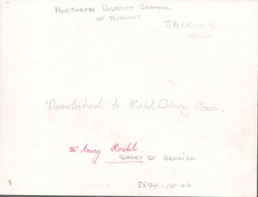 Northern District School of Nursing. Managed by Bendigo Historical Society Inc.
Photograph - Nurses hostel "McEniry"
The Northern District School of Nursing opened in 1950 in to address the issues around nurse recruitment, training and education that had previously been hospital based. The residential school was to provide theoretical and in-house education and practical training over three years. The students would also receive practical hands-on training in the wards of associated hospitals. The Northern District School of Nursing operated from Lister House, Rowan Street, Bendigo. It was the first independent school of nursing in Victoria and continued until it closed in 1989.NDSN McEniry House, Short Street Bendigo, demolished to build dining room. Photo has two names Sander's House and McEniry House, further research required.NDSN McEniry House, Short Street Bendigo, demolished to build dining room.ndsn, nursing -
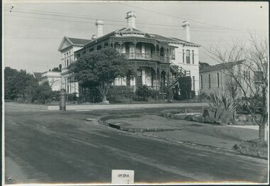 Uniting Church Archives - Synod of Victoria
Photograph, undated
Otira was designed and built in 1887 by architect Mr Crouch, first Secretary of the Institute of Architects for Mr Henry Berry, founder of a successful wholesale grocery business. The house was acquired by the Methodist Church in 1923 for use as a home missionary training college. The house is of faced stone on a bluestone foundation. The large front door is surrounded by lead light windows surmounted by a fan light. The land on which the house stands has now been subdivided.B & W gloss photograph mounted on card of Otira, the Home Missionary Training College located at 73 Walpole Street Kew. The photograph was taken from the street.Otira 73 Walpole Street Kew. Home MIssionaries Training College. otira, methodist home missionary training college walpole street kew, henry berr crouch -
 Port Melbourne Historical & Preservation Society
Photograph - Station Hotel, corner Bridge and Station Streets, Port Melbourne, c. 1950
Black & white photograph of the Station Hotel with Railway reserve & Bridge Street in the foreground.On reverse ' Station Hotel Cnr Bridge & Station Streets'business and traders - hotels, built environment - commercial, built environment - domestic, station hotel -
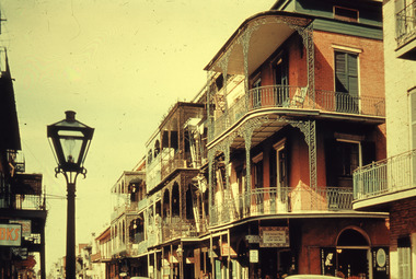 Robin Boyd Foundation
Slide, Commercial, 1956-1957
Robin Boyd developed a close friendship with the founder of the Bauhaus in Weimar Germany, Walter Gropius, who had moved to the USA in the 1930s. Through this connection, Boyd was invited to be the Massachusetts Institute of Technology (MIT) Bemis Professor at the School in the North American academic year 1956-7. Robin and Patricia Boyd, with their youngest daughter Suzy, were based in Cambridge, Massachusetts for the year. Boyd gave some lectures at MIT and he was also invited to give lectures at many other universities, allowing him to travel widely within the USA, especially on the East Coast. This gave him the opportunity to meet architects like Frank Lloyd Wright, Eero Saarinen, Paul Rudolph and many others, and visit the offices of Skidmore, Owings and Merrill, and places like Taliesin and the General Motors Technical Center Detroit. On the way home, the Boyds visited London, Berlin, Paris and Le Corbusier’s Ronchamp Chapel in France.Colour slide in a mount. St Peter Street, New Orleans, Louisiana, USASt. Peter Street / RB / C (All Handwritten)mit bemis professorship, mit, robin boyd, slide -
Glenelg Shire Council Cultural Collection
Photograph - Photograph - Julia St Portland, Victoria, n.d
Black and white photo. Julia St. Portland, between Percy and Bentinck Streets, looking westBack: 'Julia Street, Portland' - black print -
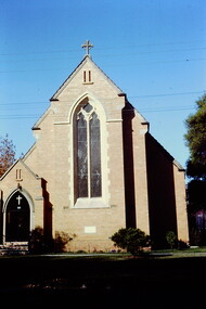 Kew Historical Society Inc
Slide - St Hilary's Anglican Church, Kew, 1979
One of a group of slides taken by members of the Society of built heritage in Kew in 1979-80. The selection of subject matter reflects the priorities of the period. The colour of some slides has degraded.The slides represent a snapshot in time of built architecture in Kew, much of which has changed in the forty-plus period since they were created.Colour positive transparency (slide) of St Hilary's Anglican Church in John Street Kew, 1979."St Hilary's Church of Engand John Street"historic houses -- kew (vic.), churches -- kew (vic.), anglican churches -- kew (vic.), st hilary's church -- kew (vic.) -
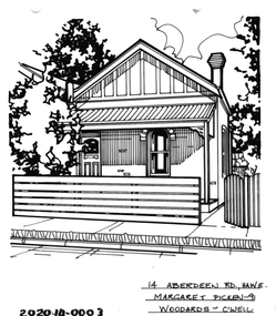 Hawthorn Historical Society
Drawing - Property Illustration, 14 Aberdeen Street, Hawthorn
'After training as a Cartographic Draftsman within the mining industry, I worked as a property illustrator for real estate firms in the eastern suburbs of Melbourne for 23 years from 1983. I initially photographed houses with a Polaroid camera and made a 'thumbnail' sketch while there. The photos were used to scale off a sketch in pencil and then that sketch was overlaid with drafting film and the 'pen and ink' completed. The pens I used were the Rotring ‘Rapidigraph’ drafting pens. The ink was also made by Rotring (German).The film was ‘Rapidraw’, polyester drafting film, double matte. It takes a very fine line and doesn’t bleed. As well as house sketches, there were often floor plans and site plans ordered. Aerial sketches were ordered when the property needed an overall view.' (Margaret Picken, 2020)This property illustration is one of a series created by Margaret Picken for a range of real estate agents in Melbourne between c. 1983 and c. 2006. Each work is signed and dated by the artist.Gift of Margaret Picken, 2020Pen and ink property illustration on drafting film of 14 Aberdeen Street, Hawthorn by Margaret Picken.14 Aberdeen Street Hawthorn Margaret Pickenartist - margaret picken 1950-