Showing 2182 items
matching timor st
-
 Eltham District Historical Society Inc
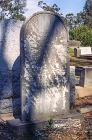
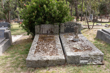
Negative - Photograph, Harry Gilham, Grave of Janet and William Morris, Eltham Cemetery, Victoria, Sep 2009
William Morris was born in Little Eltham in 1851. He was married three times; his second wife had the same surname as his first so they may have been sisters. He was described as "jolly and hearty" and ran a publican's booth at the Eltham Races in 1903, reportedly doing a good trade. He was an Eltham Shire Councillor between 1897 and 1918 and was Shire President in 1911. The Evelyn Hotel was situated in Main Road Eltham, immediately opposite its competitor the Eltham Hotel. It had opened as the Fountain of Friendship Hotel by 1854, when it was described as having "twelve spacious apartments all canvassed and papered", but had changed its name by 1878. The proprietor from about 1889 until 1919 was William Morris; he was also the licensee for most of that time. (The William Morris who was a butcher at Eltham in the early 1900s was no relation.) It advertised that it had "good stables", located behind the hotel in Pitt Street, a necessity for hotels at the time. Mail coaches en route from Heidelberg to Queenstown (now St Andrews), Panton Hill and Kangaroo Ground changed horses there. It was de-licensed as a hotel in 1919 but continued to operate as a boarding house until it was destroyed by fire in 1931. William died in 1922 and is buried in Eltham Cemetery with several other family members. Janet The Beloved Wife of William Morris Who died 5th October 1880 Aged 24 years Also Alfred George Morris Died 11th September 1880, aged 1 year Also William Morris Died 8th December 1922 Aged 74 years At RestRoll of 35mm colour negative film, 6 stripsKodak GC 400-9eltham cemetery, gravestones, alfred george morris, janet morris, william morris, evelyn hotel -
 Eltham District Historical Society Inc
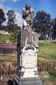
Negative - Photograph, Harry Gilham, Grave of Alfred and Margaret Armstrong, Eltham Cemetery, Victoria, Sep 2009
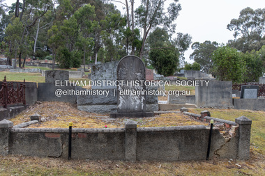
Alfred Patrick Armstrong was born in England in 1825 and was employed under the renowned Isambard Kingdom Brunel as a civil engineer during the construction of the Great Western Railway and the South Wales Railway. He came to Melbourne in 1852 and purchased property in Eltham. He became a mining surveyor and was Inspector of Mines and the Mining Registrar for the St Andrews Division of the Castlemaine Mining District. In 1855, he chaired a meeting calling for a bridge to be erected across the Yarra River between Eltham and Temple Stow. He was registered as an innkeeper in 1858, was a recognised collector of the £110 raised for the building of the first building of State School No. 209 (Eltham Primary) and was a Trustee for the Church of England site on the Eltham Cemetery Trust in 1860. He was elected to the Eltham District Road Board (forerunner of Eltham Shire Council) from 1867 to 1871 and then served as an Eltham Shire Councillor from 1871 to 1878 (including Shire President in 1873). Margaret Armstrong to whom he was married in 1854 at St Pauls Church, Melbourne, died on the 27th March 1887. Alfred died in 1893, having been in ill health for some time, and is buried in Eltham Cemetery with his wife Margaret. The monument features a tall pillar capped with a draped urn: a symbol of death. In Loving Memory of Alfred Armstrong Died May 27tth 1893 Aged 68 years Also of his wife Margaret Died March 27th 1887 Aged 63 years This burial site is of special interest as the monument has the tallest pillar-a vase-a draped cloth top (unfulfilled life) and additional panels of names around the sides and the base, which include: Ada Gertrude Armstrong, beloved daughter of Alfred & Margaret Armstrong, died May 30th 1878, aged 21 years Mary Armstrong, beloved mother to Alfred Armstrong, died April 10th, 1886 aged 82 years Arthur Vivian Harrison, died 4th Nov. 1899, aged 8 years Arthur Reynolds Stockwood Armstrong, son of Alfred Armstrong, died 4th Nov. 1908, aged 43 years Laura Augusta Harrison nee Armstrong, died 26th July 1921, aged 64 yearsRoll of 35mm colour negative film, 6 stripsKodak GC 400-9eltham cemetery, gravestones, alfred armstrong, margaret armstrong, ada gertrude armstrong, arthur reynolds stockwood armstrong, arthur vivian harrison, laura augusta harrison (nee armstrong), mary armstrong -
 Eltham District Historical Society Inc
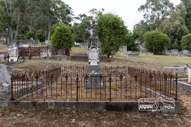
Photograph, Peter Pidgeon, Grave of Alfred and Margaret Armstrong, Eltham Cemetery, Victoria, 5 April 2021
Alfred Patrick Armstrong was born in England in 1825 and was employed under the renowned Isambard Kingdom Brunel as a civil engineer during the construction of the Great Western Railway and the South Wales Railway. He came to Melbourne in 1852 and purchased property in Eltham. He became a mining surveyor and was Inspector of Mines and the Mining Registrar for the St Andrews Division of the Castlemaine Mining District. In 1855, he chaired a meeting calling for a bridge to be erected across the Yarra River between Eltham and Temple Stow. He was registered as an innkeeper in 1858, was a recognised collector of the £110 raised for the building of the first building of State School No. 209 (Eltham Primary) and was a Trustee for the Church of England site on the Eltham Cemetery Trust in 1860. He was elected to the Eltham District Road Board (forerunner of Eltham Shire Council) from 1867 to 1871 and then served as an Eltham Shire Councillor from 1871 to 1878 (including Shire President in 1873). Margaret Armstrong to whom he was married in 1854 at St Pauls Church, Melbourne, died on the 27th March 1887. Alfred died in 1893, having been in ill health for some time, and is buried in Eltham Cemetery with his wife Margaret. The monument features a tall pillar capped with a draped urn: a symbol of death. In Loving Memory of Alfred Armstrong Died May 27tth 1893 Aged 68 years Also of his wife Margaret Died March 27th 1887 Aged 63 years This burial site is of special interest as the monument has the tallest pillar-a vase-a draped cloth top (unfulfilled life) and additional panels of names around the sides and the base, which include: Ada Gertrude Armstrong, beloved daughter of Alfred & Margaret Armstrong, died May 30th 1878, aged 21 years Mary Armstrong, beloved mother to Alfred Armstrong, died April 10th, 1886 aged 82 years Arthur Vivian Harrison, died 4th Nov. 1899, aged 8 years Arthur Reynolds Stockwood Armstrong, son of Alfred Armstrong, died 4th Nov. 1908, aged 43 years Laura Augusta Harrison nee Armstrong, died 26th July 1921, aged 64 yearsBorn Digitaleltham cemetery, gravestones, ada gertrude armstrong, alfred armstrong, arthur reynolds stockwood armstrong, arthur vivian harrison, laura augusta harrison (nee armstrong), margaret armstrong, mary armstrong -
 Eltham District Historical Society Inc
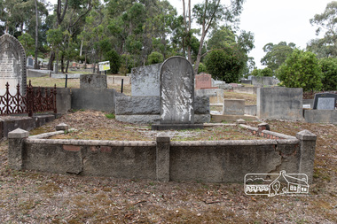
Photograph, Peter Pidgeon, Grave of Janet and William Morris, Eltham Cemetery, Victoria, 5 April 2021
William Morris was born in Eltham in 1848 or 1849. He was married three times; his second wife had the same surname as his first so they may have been sisters. He was described as "jolly and hearty" and ran a publican's booth at the Eltham Races in 1903, reportedly doing a good trade. He was an Eltham Shire Councillor between 1897 and 1918 and was Shire President in 1911. The Evelyn Hotel was situated in Main Road Eltham, immediately opposite its competitor the Eltham Hotel. It had opened as the Fountain of Friendship Hotel by 1854, when it was described as having "twelve spacious apartments all canvassed and papered", but had changed its name by 1878. The proprietor from about 1889 until 1919 was William Morris; he was also the licensee for most of that time. (The William Morris who was a butcher at Eltham in the early 1900s was no relation.) It advertised that it had "good stables", located behind the hotel in Pitt Street, a necessity for hotels at the time. Mail coaches en route from Heidelberg to Queenstown (now St Andrews), Panton Hill and Kangaroo Ground changed horses there. It was de-licensed as a hotel in 1919 but continued to operate as a boarding house until it was destroyed by fire in 1931. William died in 1922 and is buried in Eltham Cemetery with several other family members. Janet The Beloved Wife of William Morris Who died 5th October 1880 Aged 24 years Also Alfred George Morris Died 11th September 1880, aged 1 year Also William Morris Died 8th December 1922 Aged 74 years At RestBorn Digitaleltham cemetery, gravestones, alfred george morris, evelyn hotel, janet morris, william morris -
 Eltham District Historical Society Inc
Photograph, Peter Pidgeon, Graves of Mary Josephine Swallow, John Swallow (unmarked) and Patricia Catherine Hill, Eltham Cemetery, Victoria, 5 April 2021
On the 29th of May 1954, a local Eltham carpenter by the name of John Swallow, committed a double murder at his home on New Street. This happened on the same day as the federal election of that year. John 48, his wife Mary 47, and stepdaughter Patricia 25, all went to the Eltham Courthouse on Main Road to cast their vote in the election that Saturday. After voting they returned home to their New Street house around midday. Patricia would later recall to ambulance officers, that she was feeling unwell, and so went to lay down when she heard an argument erupt over voting between her mother Mary and stepfather John. A concerned neighbour heard loud thudding noises and yelling coming from John and Mary’s house, he went to investigate. When he arrived at the house he was met by John at the front door. He would later describe John as “having a frantic look upon his face, and manic eyes”. John must have been a sight, bleeding and clutching a cut throat razor by his side. He then announced to the neighbour, “they voted commie!” before turning and going back inside. The distressed neighbour immediately raced home to call the Police. When the police arrived, they found Mary dead on the kitchen floor from catastrophic head injuries; her daughter, Patricia, clinging to life, slumped on her bed. Both women had been attacked by the same weapon, a large hammer, or sledge hammer as reported by the newspapers. John was also discovered in the house, bleeding from self-inflicted wounds from the razor, and had attempted to ingest caustic soda. Patricia was taken to St Vincent’s hospital, but died the following day, the 30th of May. John was also taken to St Vincent’s, where he remained under constant police guard for several months while he recovered from his injuries, at least the physical. He was eventually well enough to be taken to the City Watch House and then Pentridge Prison before his trial in October of the same year. When it came time for John to face the courts, the Judge called a mistrial, the Crown would not prosecute on the grounds of insanity. John was led away from the dock of The Magistrates Court and taken directly to Willsmere, the Kew Mental Asylum. On the 9th of August 1962, John Mervyn Swallow died of heart failure, he was 57. He had been a resident of Kew for four years. John’s body was returned to Eltham Cemetery and buried in the same grave as Mary. There is no mention of his name on the head stone. Patricia’s grave is next to Mary and John. A sad irony has an angel upon her grave, “its head missing”, possibly vandals or just an accident of time and events. What became of the home where all of this took place on New Street shall remain a mystery but within six months of this horrific event, the street had been re-named to Lavender Park Road after the original property near the end of the road, Lavender Park. In Memory Of Mary Josephine Swallow Died 29th May 1954 aged 47 Also Patricia Cathryn Hill Dearly beloved wife of Kel Called home 30th May 1954 Aged 25 yearsBorn Digitaleltham cemetery, gravestones, mary josephine swallow, patricia catherine hill, john swallow -
 Eltham District Historical Society Inc
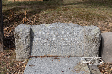
Photograph, Peter Pidgeon, Grave of Sarah Jane Procter, Eltham Cemetery, Victoria, 5 April 2021
Nurse Sarah Procter stretched the limits by enlisted on 12 August, 1915 at 45 years of age, the maximum acceptable age. A sister, Mrs J H Treloar (Amelia) in Hamilton was given as next of kin. Her Attestation shows she had 13 years nursing experience, having earned her Certificate at Stawell Hospital, served for one year with the Women's Hospital with the balance with private amenities. The Embarkation Roll lists her residential address simply as Brunswick - there is no Attestation or other material surviving to suggest a more specific address. She embarked from Melbourne on board RMS Morea on 24 August, 1915 and like many the served in Egypt in 1915, her record is a little hazy, but it appears at in January, 1916 after serving with No. 2 AGH, she was promoted to Nursing Sister and returned on HMAT Ulysses transporting wounded back to Australia. Nurse Procter embarked again on 4 April, 1916 to re-join her unit. She arrived in England 30 December after further service at Alexandria and was initially assigned to No. 2 A.A.H, then at Southall, She was transferred just a few weeks later to No. 1 AAH at Barefield where she remained until February, 1918. She proceeded to join No.5 AGH at Rouen, France in May, 1918; she returned to England on 23 November, 1918 after spending a month off duty with general debility and on return was admitted to South Kensington hospital with rheumatism. She was released around a fortnight later and at the same time promoted to the rank of Sister. Perhaps because of her age, she embarked for Australia soon afterwards and was assigned to No. 11 AGH at Caulfield from 9 February, 1919 until her appointment was terminated on 3 May. Born Stawell, Protestant, Sarah Jane Procter died at 75 years of age in a private hospital in St. Kilda, on 6 July, 1945 as the result of an accident and was interred in Eltham Cemetery. Her National Archives are held as Procter, AWM files as Proctor, the former is correct. (Brian Membery for Wikinorthia) Sarah Jane Procter never married and served in WW1. She enlisted at 45, but said she was only 40 on the enlistment papers. Sarah is buried in CE Monumental Section Grave 182. She was born in Stawell in 1869 and died accidentally in Heidelberg 1945. She lays next to an older brother, George Charles Alfred Procter, born 1865. died 1935 in grave CE 181. In Loving Memory of Sarah Jane Proctor Late Sister A.I.F. Died 6th July 1945 aged 76 years Blessed are they that die in the Lord For their works do follow them.Born Digitaleltham cemetery, gravestones, proctor, george charles alfred procter, sarah jane procter -
 Eltham District Historical Society Inc
Photograph, Peter Pidgeon, Grave of Janet and William Morris, Eltham Cemetery, Victoria, 5 Oct 2022
William Morris was born in Eltham in 1848 or 1849. He was married three times; his second wife had the same surname as his first so they may have been sisters. He was described as "jolly and hearty" and ran a publican's booth at the Eltham Races in 1903, reportedly doing a good trade. He was an Eltham Shire Councillor between 1897 and 1918 and was Shire President in 1911. The Evelyn Hotel was situated in Main Road Eltham, immediately opposite its competitor the Eltham Hotel. It had opened as the Fountain of Friendship Hotel by 1854, when it was described as having "twelve spacious apartments all canvassed and papered", but had changed its name by 1878. The proprietor from about 1889 until 1919 was William Morris; he was also the licensee for most of that time. (The William Morris who was a butcher at Eltham in the early 1900s was no relation.) It advertised that it had "good stables", located behind the hotel in Pitt Street, a necessity for hotels at the time. Mail coaches en route from Heidelberg to Queenstown (now St Andrews), Panton Hill and Kangaroo Ground changed horses there. It was de-licensed as a hotel in 1919 but continued to operate as a boarding house until it was destroyed by fire in 1931. William died in 1922 and is buried in Eltham Cemetery with several other family members. Janet The Beloved Wife of William Morris Who died 5th October 1880 Aged 24 years Also Alfred George Morris Died 11th September 1880, aged 1 year Also William Morris Died 8th December 1922 Aged 74 years At RestBorn Digitaleltham cemetery, gravestones, alfred george morris, evelyn hotel, janet morris, william morris -
 Eltham District Historical Society Inc
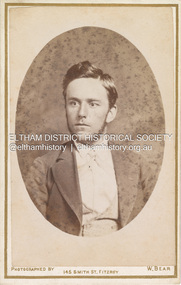
Photograph, W. Bear, Possibly Sarah Ann Shillinglaw’s brother, William Kidd (1853-1901), c.1880
William Bear, Photographer operated from 145 Smith Street, Fitzroy from 1877 to 1882. Prior to that the address was occupied by F.C. Burman to 1876 and followed by W. Latimer in 1883 (Sands Melbourne Directory) Marg Ball suggested the fellow may possibly be a Kidd. Put side by side with Sarah Ann Shillinglaw (nee Kidd) and he certainly could be a brother. Looking at Sarah and her siblings, 2nd eldest William seems the most/only candidate given the date of the photo. William Bear only operated from 145 Smith St., Fitzroy from 1877 through 1882. The fashion/hair/whiskers suggest it is moving out of the 1870s and into the 1880s so it is fairly reasonable to suggest circa 1880 for the photo. At that time, William would be 27 – looks right. The only other two brothers, Samuel and Matthew had both died as youngsters years earlier. Further, the placement of the photo in the album on the opposite page to the only photo of Sarah suggests there is a close relationship. CARTE-DE-VISITE (cdv) 1857-1890 Cartes-de-visite (cdv's) are the most common form of photograph from the nineteenth century, generally measuring two and a half inches by four and an eighth inches (6.3 x 10.5 cm) when mounted, sepia toned, mounted on a card which was generally printed with the photographer's name and address on the back or beneath the portrait. - Frost, Lenore; Dating Family Photos 1850-1920; Valiant Press Pty. Ltd., Berwick, Victoria 1991marg ball collection, shillinglaw family photo album 1, 1877-1882, 1880, w. bear photographer 145 smith st fitzroy, william kidd (1853-1901) -
 Eltham District Historical Society Inc
Document - Photocopy, Diamond Valley News, Newspaper article: Fred looks back by Linley Hartley, Diamond Valley News, c.1985
Fred looks back; Report: Linley Hartley, Picture: Ron Grant Teaching himself German again after 70 years is just one of the many tasks Fred Golgerth, of Greensborough, has undertaken and succeeded in during his lifetime. As the two year old tenth child of a German descendent, Fred learnt to speak German from an Aunt. But World War 1 was raging. Fred’s older brother had gone to Europe with the Australian forces, changing his name … to ….. to sound less German. “I used to get my bottom slapped for speaking German at home,” Fred said. Even his name was changed from Otto to the more anglicised Frederick. Fred claims his involvement with Eltham started two years before he was born! His sister, two years older than him, was a babe in arms when his parents bought a piece of grazing property in Mount Pleasant Rd. “It was about 24 acres on a spur of Mt Pleasant,” Fred said. “My parents bought it from Mr and Mrs Hughes. There was a two-room mud hut in wattle and daub that we lived in from time to time. “My parents had a dairy farm and dairy in West Coburg, and they bought the Mt Pleasant land to put the dry stock on. “At one stage my mother got very ill and my older sister took my younger sister and myself to Eltham for four or five months. I went down to Eltham Primary School then.” That wasn’t the only time Fred stayed in Eltham. His sister, Wilhemina, known as Willa, married Jim Watson who had the Eltham hotel for some years from the end of World War 1. Pillar to post living was the way Fred described his youth, when he stayed with one married sister after another. “After a while Will and Jim lived in the big house at the top of Pitt St, next to the Council depot, and the hotel was managed by Fitzsimmons who had a big place near the river down there on Fitzsimons Lane. There was no bridge in Fitzsimons Lane but we used to cross the river at a ford, rolling up our trouser legs so they wouldn’t get wet, and carrying our shoes. I’d o down to visit some friends I had in Templestowe. And sometimes Jim Watson took his horse drawn lorry across the ford on his way to the brewery, instead of going don through Heidelberg.” “The bridge across the Yarra in Fitzsimons was not built until 1961.” Fred Golgerth, was only a teenager when he was rolled off his pushbike under a car on the bend between Mt Pleasant Rd and the Diamond Creek bridge. He was hospitalised in the little hospital on the east side of Eltham village that served the district in those days. He still carries the scars of the burns he received from the exhaust pipe and recent x-rays have revealed several broken vertebrae. At the time of the accident he was treated for a dislocated neck and was in plaster from his hip to the base of his head for about seven months. But nothing daunted Fred. Bouncing back he began work as an apprentice to a motor mechanic in Bell St, Preston, a man who is still living (at 90) in Queensland and who still communicates with Fred frequently. “He was like a father to me,” Fred declared. He was a marine engineer as well, so I …. that as well as blacksmithing. They taught us properly then.” After finishing his apprenticeship, Fred bought himself a 30 hundredweight Fargo truck and began his own contract carting business, doing most of the work for a firm called Carnegie’s and a subsidiary of that, Howard Radio. It was in the office Fred met his wife. “He taught me to drive the truck giving me lessons in my lunch hours up the Bourke St and Flinders St extension,” she said. “After work I’d have a driving lesson and all the girls from the Howard Radio would pile in the back to get a lift to Richmond Station.” In the 1939 bushfires, the Mt Pleasant Rd property was burnt out and the hut raised. Two years later, Fred and Dorothy were married. Fred paid £7.15.0 ($15.50) for the suit in which he was married. Dorothy had pulled out of the Women’s Air Training Corps to be married. Others with whom she trained went to Darwin and were in a convoy that was bombed. Fred went into the garage business in Brighton and continued his cartage business for a while. His company was employed to do all Brown Gouge’s motor repairs and factory maintenance. Because Fred had a certificate to do steam repair work he often got jobs maintaining industrial boilers. While he was in Brighton, Fred bought an eight-seater 1925 Silver Ghost Rolls Royce from Sir Keith Murdoch. When the couple moved to Rosanna in about 1943, it became a delivery van for the dairy they operated. “I thought I’d like to get back into a dairy business” Fred said. “We used to deliver the milk in the Rolls. “But it was hard work. We couldn’t get the labour and we’d drive to the farm and pick up the milk cans, take them back to the dairy, cool the milk, bottle it and deliver it. The inspectors would come regularly and the walls for bacteria.” Fred was exhausted. The couple gave up the dairy and moved to Eltham to live on the old property where a weatherboard house had now been built. It wasn’t a big house and the glassed in Rolls Royce limousine became the daytime nursery for the Golgerth’s second daughter. We’d put her in there to sleep during the day.” “Dorothy Golgerth was known to drive the Rolls at breakneck speed along Mt Pleasant Rd. Fred took some time off work then began driving a little local bus run by the Lyon Brothers before taking a maintenance job at the Athenaeum Club in the city. He’d ride an old Harley-Davidson to the station and travel into the city by train. Later, when the family moved to Pryor St. (their house stood where McEwans car park is now) Fred could walk to and from the station. “There was no resident doctor in the early days of Eltham,” Fred said. “Dr Cordner used to come from Greensborough to a room in the old house next to the old grocery shop on the corner of York St and Main Rd, Eltham (the grocery shop is now the Eltham Feed and Grain Store). The Golgerths lived in Eltham until “Dollar Day” – the day decimal currency became official. They eventually moved to Greensborough, when they have lived since. Fred has had his share of interesting jobs since then, retiring at 65 seven years ago when he was working in the engineering department at Larundel. Recently, two of his older sisters and a brother died, within a month. They were all in their 80s. They all had a profound influence on Fred, especially during his youth. His sharp wit and amusing anecdotes are the richer for his having been the youngest of a family that made the best of every circumstance. And now, as he enjoys his retirement, he is concentrating on relearning the language of his infancy; teaching himself German from tapes and a ‘teach yourself’ manual. He is fiercely proud of his German ancestry and treasures the diary, written in German in Gothic script, kept by his grandparents during their journey to Australia. On the inside in blue pen: "To Sadie, Wal Margaret & Elizabeth with lots & lots of love & best wishes from Mother"marg ball collection, eltham hotel, herbert james watson, otto (fred) golgerth, wilhemina watson (nee golgerth) -
 Eltham District Historical Society Inc
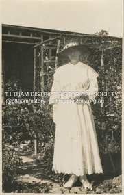
Photograph, Ellen Sweeney in Mrs Cox's garden, Eltham, Easter Sunday, April 16, 1922
Jackson St Casterton Aug 18. 23 Dear Girls, I was very pleased to receive your nice letters with news of your doings in Eltham. You put Casterton S.A., so your letters were a long time reaching me. As I hope to see you all very soon I shall just send a p.c. of me taken in Mrs Cox’s garden Easter Sunday 12 months ago. The river here has been in flood twice and people who lived along its banks had to move. I believe the Eltham PS is greatly improved. Betty says I shall get lost there now. Casterton is on the Glenelg R. in Vic so you will remember that next time. Best wishes to you all. From E. Hooley Ellen Sweeney was a former student of Eltham State School in the 1880s, She became a teacher at the school from 1891-1898. She returned in 1915 until her marriage to William Hooley of Casterton at St Marys, Eltham, Tuesday, April 24, 1923. Wedding at Eltham. (1923, April 27). Advertiser (Hurstbridge, Vic. : 1922 - 1939), p. 2 (AFTERNOON). Retrieved February 14, 2023, from http://nla.gov.au/nla.news-article56655781 Wedding at Eltham PRESENTATIONS TO MISS SWEENEY. On Tuesday last. Miss Sweeney (a member of an old and respected Eltham family), who recently resigned her position as assistant teacher at the Eltham State School to marry Mr. W. Hooley, of Casterton, was presented with a handsome gold wristlet watch. The headmaster, Mr. Dudtield, in making the presentation on behalf of the school committee, parents, and children paid a high tribute to the excellent work done by Miss Sweeney during her connection with the school, and in asking her acceptance of the present, expressed on behalf of all the fullest measure of happiness to Miss Sweeney in her married life. On Thursday evening, a social evening was tendered to Miss Sweeney, at Mrs. T. Jewell's residence Main street, by the choir and parishioners of St. Mary's Church, Eltham, where Miss Sweeney has for some years acted as choir mistress. Mr. Harold Cox, in handing her a handsome gold and oak silver salad bowl and service, expressed the heartiest good wishes to one who had not only labored so strenuously in organising the choir, but had been always foremost in promoting church and public movements in the community. Congratulatory addresses were also contributed by the Rev. F. Norris and Mr. W. P. McMahon. Miss Sweeney sincerely thanked the donors for their beautiful present, and the speakers for the many kind things said in her regard. She felt very much severing her connection with Eltham. She would carry away many happy-. recollections of her old home, and the kindly people of the town. She hoped after some years to return to Eltham. permanently. (Applause.) On Saturday morning. the marriage ceremony was performed at St. Mary's in the presence of a large number of friends. During the nuptial Mass, celebrated by the Rev. F. Parker. (North Fitzroy), assisted-by the Rev. F. Morris .(Eltham). The choral part of the service including the Wedding March, was very efficiently rendered by the choir. MRS HOOLEY (1940, May 10).Eltham and Whittlesea Shires Advertiser (Vic. : 1940 - 1942), p. 4. Retrieved February 14, 2023, from http://nla.gov.au/nla.news-article57491650 MRS HOOLEY Sincere regret was felt, in Eltham and district at the death of Mrs. W. Hooley (nee Miss Ellen Sweeney) a very dear and capable teacher at State Schools in Eltham and other districts, including the Western District. The deceased was one of Nature's ladies, and was a native of Eltham having been born in the historic home, Culla Hill, one of the first settlements on the Yarra. She passed peacefully away on Anzac Day, April 26. The. funeral was the largest and most impressive ever seen in Eltham, and left St. Mary's Church after a requiem mass conducted by Rev. Father Morrison and Father Hollis. The pall bearers were mostly girlhood friends. Deceased leaves a husband, two brothers, Mr. Tom Sweeney of Kew, and Mr. Frank Sweeney of Western Australia and sisters (Mrs. Lane, of W.A., and Mrs. M. Carringham, of Dalton St, Eltham.) POSTCARD 1905-1940s Like the carte-de-visite, postcards enjoyed a collecting craze by large numbers of people, and were often kept in albums through which the interested visitor could browse. Postcards were posted or exchanged in huge numbers. Postal authorities in Australia only allowed the private printing of postcards from 1898. At this time the back of the card was reserved for the address and postage stamp, and the front was used for the message and a picture. In 1902 British authorities allowed a "divided back", so that the left side could be used for the message, the right side for the address and stamp, and the whole of the front was devoted to the picture. France followed suit in 1904, Germany and Australia in 1905, and the United States in 1907. - Frost, Lenore; Dating Family Photos 1850-1920; Valiant Press Pty. Ltd., Berwick, Victoria 1991marg ball collection, postcard, 1922, 1923, ellen hooley (nee sweeney), ellen sweeney, eltham, mrs cox -
 Eltham District Historical Society Inc
Document - Folder, Mitchell, Harold
Harold Mitchel, advertising businessman, was the son of a saw miller in Stawell and recounted his childhood in "Living Large". He eventually lived at St Andrews, was appointed an Officer (AO) of the Order of Australia in 2004 and a Companion (AC) of the Order of Australian in the Queen's Birthday honours 2010, for his community service, leadership, philanthropic contribution to art, heath and education, and support of humanitarian aid in East Timor and Indigenous communities. He also held board positions on a number of arts organisations. He died from complications following knee surgery in February 2024. Contents Newspaper article: "Gong for Mitchell", Diamond Valley Leader, 23 June 2010. Harold Mitchell appointed AC Companion of the Order of Australia in the Queen's Birthday honours. Newspaper article: "The Power and the Passion", The Weekly Review, 23 November 2011. Interview of Harold Mitchell. Newspaper article: "Break point", GoodWeekend, 7 November 2020. Interview of Harold Mitchell. Newspaper article: "Ad man, philanthropist dies at 81", The Age, 12 February 2024. Two obituaries of Harold Mitchell, noting his Order of Australia 2010, his philanthropic interests, his seats on boards of cultural organisations, his business Mitchell & Partners. Newspaper article: Notice of state memorial service for Harold Mitchell AC, The Age, 4 May 2024. Newspaper article: "Farewell for 'a giver, not a taker' who helped others", The Age, 14 May 2024. Report of state memorial service for Harold Mitchell. Newspaper article: "Mitchell's luxury city penthouse yours for 46.25m", The Age, 7 June 2024. Harold Mitchell's penthouse in Park Tower, Spring Street, for sale. Newspaper clippings, A4 photocopies, etcharold mitchell, mitchell & partners, "living large" book, park tower spring street melbourne -
Glen Eira Historical Society
Book - St. Agnes Church, Booran Road, 116, Glen Huntly
Love So Amazing, a 184 page book with sixteen chapters and index. A History of the Parish of St. Agnes Glen Huntly 1888-1993 by Neville Drummond. The chapters document parishioners, events, festivals, church fellowship groups and numerous sports clubs and choirs. It is also a time capsule of interesting facts of Melbourne and particularly of Caulfield. There are various photos including ones of many of the Reverends. There is also a list of gifts and memorials. The book was published in 1993 and donated by Margaret Dunbar on 25/08/2004.glenhuntly, glen huntly, st. agnes church, drummond neville, memorials, organs, booran road, wright nigel, clarke alice, clarke wilfe, agg george, agg val, barren john, barren christine, halstead brian, halstead donna, sturgess nancy, brock jean, hunter ian, cuttriss frank, porter brian, mcdonald norman, fryer neil, thomas malcolm, moore david, hatters alvin, laity alan, blair linda, dowling lawrie, tidy dorothy, worthington mary, cheshire jean, thiele bevan, marks marjorie, parnell joy, parnell bob, rose glynis, jolly betty, hocking hazel, thiele mollie, glazner jean, pereira noble, worthington bill, tidy bruce, goodison gwendoline, elliot june, scoot jo, boxshall ormee, chalres ernie, maghony lois, scheibner esmee, rayner keith rev., macgowan malcolm, macgowan jean, heatherbrae, house names, st. mary’s church, caulfield, st. catherines church, camden town, south caulfield, booran road church of england, bent street, sunday schools, monro roy, leech irene, monro victor, parochial council, slate tiles, timber houses, clarke alfred e., tennis clubs, cricket clubs, football clubs, children, keble clubs, basketball clubs, boy scouts, erlandsen stephen, erlandsen chris, patience tim, stevenson garry, lafitte gabriel, thomas malcolm, thomas richard, hall roderick, baker-smith john, hardwick ken, oram garry, whyte doug, davis richard, dowling laurie, mcphee peter, boys choir, youth clubs, mothers clubs, friendly societies, church furniture, brick, vicarages, newsletters, choirs, gardens -
Glen Eira Historical Society
Letter - Crotonhurst
A letter from Mrs M Ring to the Caulfield Historical Society, dated 14/03/1986, conveying gratitude for the information provided about the house Crotonhurst located at the corner of Hawthorn Road and Glen Eira Road, Caulfield North, and requesting information about the Langdon and Webb families and the property Lirrewa. Enclosed with the letter is a copy of a two page report on the Life of George Frederick Webb. The file also includes a seven page report conducted by Irene Victoria Anderson in 1982 on the history of the Langdon and Webb families and the house Crotonhurst. Two earlier drafts of the same report are included and one of these has further handwritten notes.crotonhurst, rosecraddock, lirrewa, caulfield north, hawthorn road, langdon road, glen eira road, mitchell road, crotonhurst avenue, caulfield city hall, city of caulfield, polo ground, polo parade, neerim road, powderham road, walworth avenue, langdon family, webb family, rosecraddock family, webb george henry frederick, webb george henry webb justice, field matilda, agg sophia sarah, agg sophia sarah annie, webb sophie sarah annie, agg dottie, webb dottie, langdon william farrar, langdon willie, langdon bill, langdon h j mrs, langdon mrs, webb george edward, webb matilda elizabeth, webb isabella elizabeth, webb james hemming, murray peter r, wells john c, langdon marie, langdon clive, murdoch keith, egerton-warburton mr, yorston mr, yorston rita, langdon violet, langdon. philip, gillespie ray, lindsay joan, ring m, paterson mrs, coffey eileen, fitzsimmons eileen, ronald heather, william gluyas, maidment isobel, langdon rr, langdon charles, langdon r b, knox david, langdon dick, hart trevor, mclaughlin j, ballantyne r, webb matilda sarah, somers charles, mckenzie barbara, mcleod lexie, richards barbara, richards lexie, sims betty, anderson irene victoria, short hand writer, lawyers, phthisis, queen’s counsel, judge of the supreme court, court reporter, architectural features, world war 1914-1918, soldiers, point to point steeplechase, master of the hounds, organs, sculptor, statues, stained glass, crests and emblems, elsternwick congregational church, government shorthand writers’ department, eureka treason trials, swamp sand and heath, dickson and yorston, caulfield council, caulfield historical society, harrison ramsay, time without clocks, the hounds are running, melbourne hunt club, st mary’s church, geo. fincham and sons, city hall gallery, mansions -
 Eltham District Historical Society Inc
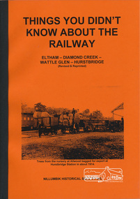
Book, Things You Didn't Know about the Railway: Eltham, Diamond Creek, Wattle Glen, Hurstbridge, 2017
Update of 1st editon by Jock Ryan published in March 2003. 2nd edition (Revised) Nillumbik Historical Society December 2017 Brief history of the agitation and eventual extension and opening of the Hurstbridge Railway line from Eltham to Diamond Creek, Wattle Glen to Hurstbridge, which was opened in June 1912. Includes details of events thereafter including Wattle Day and Railway accidents. Profusely illustrated with black and white photographs from the collection of the Nillumbik Historical Society (Diamond Creek). Agitation for a railway extension began in 1888 when a meeting was held at Arthurs Creek to press for the construction of a railway line from Heidelberg to Kinglake. The Chairman Mr Charles Draper said this was necessary because this was the best fruit growing district in Victoria. Mr Cameron M.P. pointed out that whatever route the line took it would have to follow the Diamond Valley from Eltham. At the same time another meeting was pressing for the line to be extended to Queenstown (St Andrews). However when detailed surveys were made it was discovered that the only possible route was to Hurstbridge because of the hills. In 1912 the railway was opened terminating at Hurstbridge. Bound with orange covers. Text with black and white illustrations. 30 pages.hurstbridge railway line,diamond creek,wattle glen,hurstbridge, nillumbik historical society -
 Eltham District Historical Society Inc
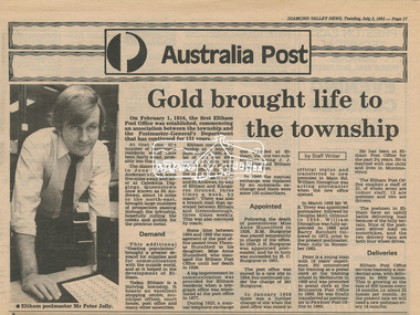
Newsclipping, Diamond Valley News, Gold brought life to the township, Diamond Valley News, 2 July 1985, p17, 2 Jul 1985
A history of Eltham Post Office. Australia Post: Gold brought life to the township - Diamond Valley News, Tuesday July 2, 1985, p17 On February 1, 1854, the first Eltham Post Office was established, commencing an association between the township and the Postmaster-General's Department that has continued for 131 years. At that time, the number of permanent residents would have been fairly small, probably less than 200. The discovery of gold in June 1851, at Anderson’s Creek, some five miles away, and later at Caledonia Diggings, Queenstown (now known as St Andrews), about 14 miles to the north-east, brought large numbers of prospectors passing through the township, hopefully culling the creeks and gullies for the precious metal. This additional "floating population" brought a greater demand for supplies and for communication with the outside world, and so it helped in the development of Eltham. Today, Eltham is a thriving township. It boasts an excellent shopping centre, municipal offices, court house. post office and many other amenities. Eltham continued to develop at a leisurely pace. During 1860, a total of just over 8000 postal articles were handled at the Eltham Post Office. By 1862, the mail route was "to and from Melbourne by way of Eltham and Kangaroo Ground, three times a week, by coach". There was also a branch mail that operated between Eltham and Greensborough, three times weekly. This was also conveyed by coach. Some time between 1864 and 1868 the management of the post office passed from Thomas Hunniford to his daughter, Miss Anne Hunniford, who managed the Eltham Post Office until her death in 1928. A big improvement in communication was provided for Eltham residents when a telegraph office was established at the post office in 1877. During 1923 a manual telephone exchange was provided at Eltham, the first two subscribers being J.J. O’Connor and Eltham Police Station. In 1949 the manual exchange was replaced by an automatic exchange and there were some 150 subscribers. Following the death of postmistress Miss Anne Hunniford in 1928, B.M. Burgoyne was placed temporarily in charge of the office. In 1929, J. N. Burgoyne was appointed postmaster, and he in turn was succeeded by H. C. Burgoyne in 1951. The post office was moved to a new site in 1954, but continued under the charge of Mr Burgoyne. In January 1958 there was a further change of site when the post office was raised to official status and transferred to new premises in Main Rd. William Donoghue was acting postmaster when the new office was opened. In March 1958 Mr W.E. Tovey was appointed postmaster, followed by Douglas McG. Gilmour in 1959. William Donoghue was fully appointed in 1966 and Barry Reichelt followed in 1973, prior to the present postmaster, Peter Jolly in November 1982. Peter is a young man with 18 years' experience. He commenced his training as a postal clerk at the training school in Melbourne in 1968 and was promoted to postal clerk at the Brunswick Post Office in 1969. He was finally transferred as postmaster to Fawkner Post Office in 1980. He has been at Eltham Post Office for the past 2½ years. He is married with one child and lives in Montmorency. The Eltham Post Office employs a staff of 21, of whom seven are indoor staff, 12 are postmen and two are drivers. The postmen in Eltham have an uphill battle delivering mail because of the hilly terrain. Nine of the postmen deliver mail on motorbikes, and the two delivery vans are both four wheel drives. Eltham Post Office services basically a residential area, with deliveries to 5600 homes. This is growing at the rate of 600 homes every 18 months, i.e. about 32 homes per month. At the present rate we will need a new postman every 18 months.Digital file only - Digitised by EDHS from a scrapbook on loan from Beryl Bradbury (nee Stokes), daughter of Frank Stokes.anderson's creek, anne hunniford, b.m. burgoyne, barry reichelt, beryl bradbury (nee stokes) collection, eltham police station, eltham post office, eltham post office history, gold, h.c. burgoyne, j.j. o'connor, j.n. burgoyne, peter jolly, postmaster, telephone exchange, thomas hunniford, w.e. tovey, william donoghue -
 Eltham District Historical Society Inc
Slide, Maroondah Aqueduct, Research, Victoria, 22 Mar. 1981
An inspection tour of the Maroondah Aqueduct was undertaken by the Shire of Eltham Historical Society on Sunday, March 22nd, 1981, commening where the aqueduct crosses Main Rd., Research, just below Eltham College. The Maroondah Aqueduct was part of Melbourne’s water supply system. It carried water over the 66 km from the Maroondah Reservoir on the Watts River at Healesville to the Preston Reservoir. Of this length, 41 km were open channel, 10 km, tunnel through hills and 15 km in 14 inverted siphons across stream valleys. The route of the aqueduct is north of Tarrawarra and Yarra Glen, along the Yarra escarpment south of Christmas Hills and crossing Watsons Creek into the present Shire of Eltham near Henley Rd. The eastern part of the route lies entirely within the former boundaries of the shire. The aqueduct passes south of Kangaroo Ground to Research and crosses the Diamond Creek by siphon at Allendale Rd., Eltham North. It then extends to Reservoir via St. Helena, Greensborough North and Bundoora. Water first flowed through the aqueduct in February 1891 when it was fed by a diversion weir on the Watts River. Records of the building of the aqueduct indicate that it was a significant construction achievement. The present Maroondah Reservoir was completed in 1927 and the aqueduct was enlarged at that time to take increased flows. About 1971 the section of the aqueduct through and north of Research was replaced by a large pipe and that section of the channel is now unused. The channel has remained largely intact (unlike sections at Greensborough and Bundoora where long lengths of the disused aqueduct have been demolished or filled in). The M.M.B.W. relinquished control of the disused aqueduct reserve which is crown land and the Shire of Eltham took control of this section of the reserve as a linear park. The Maroondah Aqueduct is considered to be an important historic structure, not just to the local area but to the metropolitan area generally. It is considered important to preserve substantially intact long lengths of the disused aqueduct, together with its bridges and other associated structures. 35 mm colour positive transparency (1 of 5) Mount - Agfachrome Agfa CS System black 8 dotsactivities, heritage excursion, maroondah aqueduct, research (vic.), shire of eltham historical society -
 Eltham District Historical Society Inc
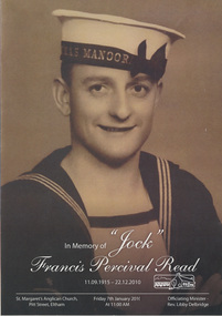
Folder, Francis Percival Read (Jock) (1915-2010)
Franics Read known as Jock, was a life time resident of Eltham. He served in the Navy in WW2. He was well loved as a long time school crossing supervisor and member of EDHS with a remarkable memory of his life's experiences. Contents 1. In Memory of "Jock" Francis Percival Read 11.09.1915 - 22.12.2010; Funeral Service Booklet (3 copies), A4 card folded. Held at St Margaret's Anglican Church, Pitt Street, Eltham, Friday 7th January 2011 at 11:00 AM 2. News clippings - Clip Clop Lollipop!, Diamond Valley News, 14 Dec 1976, p1 - Jock Read with horse, Smokey, Diamond Valley News, 1978 - School Crossing Supervisor Jock Read with horse, Lofty, Diamond Valley News, 1982 - Families shed a tear for Tackey, Diamond Valley News, 23 Apr 1985 - For fallen friends, Diamond Valley News, 16 Nov 1992 - Lollipop man calls it a day, c.1996 - Local digger leads the march, Nillumbik Mail, 3 May 2000, p5 also “Our Anzacs remembered” - Rain holds off for people's march through memories, c.2001 - For Sale; 52-54 Henry Street, Eltham, Barry Plant Real Estate, The Weekly Review, 14 Mar 2002 - Wartime's memories of mates. Photo "Jock Read stands proud in front of the Australian flag in his front yard", Diamond Valley Leader, 19 Apr 2006, p1 - Keeping the Anzac spirit alive, Diamond Valley Leader, 19 Apr 2006, p10 - Meaningful life well lived by Jim Connor, Diamond Valley Leader, 16 Feb 2011, p25 3. Draft of obituary by Jim Connor published in Diamond Valley Leader 16 Feb 2011 4. Jock Read Memorial notes 5. Jock Read Distinguished Life Member, Eltham District Historical Society 6. Distinguished Life Member presentation to Jock Read by Eltham District Historical Society at Chatsworth House, 26 July 2010 7. Photographs (qty 3) 10 x 15 cm of Jock Read at the Distinguished Life Member presentation by Eltham District Historical Society members at Chatsworth House, 26 July 2010 (Photographer possibly Jim Connor) 8. Photographs (qty 9) printed on 3 sheets of A4 photo paper of Jock Read at the Distinguished Life Member presentation by Eltham District Historical Society members at Chatsworth House, 26 July 2010 (Photographer unknown) 9. Transcript of audio tape recorded by Peter Bassett-Smith with Jock Read at the old Police Residence, 728 Main Road, Eltham during Heritage Week display, 28 Apr 1990 10. Transcript of audio tape recorded by Denis Ward of Old characters and other folk around Eltham: a chat with Jock Read and Doug Orford at Eltham District Historical Society meeting held 10 May 2000 11. Interpretative transcript of audio tape EDHS_01636 Jock Read Tape 1 – 2002 12. Transcript of audio tape Main Road Eltham: a chat with Jock Read and Doug Orford at Eltham District Historical Society meeting held 10 Sep 2002 13. Baker's Run - List of names and deliveries forming Jock Read's Baker's run and discussed at meeting held 10 Sep 2002 15. Jock Read - when asked what he used to do around about 14. Nillumbik Council Item; Jock Read Eulogy 16. Photocopy of photo: Wedding Party; Jock Read and Beryl Olivia Burgess, St Katherine's Church, St Helena 17. Celebration of the life of Beryl Olivia Read nee Burgess 1 December 1924 - 17 July 2008harry gilham collection, jock read, frances percival read, 728 main road, alison delaney, bakers delivery run, blacksmith, building industry, david johns, diana bassett-smith, doug orford, funeral service, gwen orford, harry gilham, henry street, heritage week, i remember (poem), industry, jim connor, lofty (horse), matlock police (tv show), peter bassett-smith, russell yeoman, shamus (horse), smokey (horse), sue law, tackey (horse), wally, eulogy -
 Eltham District Historical Society Inc
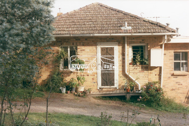
Photograph, 218 Pitt Street, Eltham, c.1985, 1985c
House was rented by Kim Tarpey between October 1983 and June 1985. It was one of the buildings originally part of Birds Orchard. Harold Bird was her landlord, a retired primary school teacher who, when she knew him was driving the mobile library bus. Her partner had him as a teacher at Montmorency Primary in grade 4. The house was next door to what is now a bushland reserve near the Pauline Toner Reserve. It was on the corner of Pitt and Arthur St - the driveway was near the roundabout and went off to the right of the driveway that now belongings to 220 Pitt street and which was bushland at the time. It was sold in 1985 and consequently demolished, a large house has replaced it. It was situated approximately where the front door of No. 218 is nowadays with the facade roughly in line with the now garage wall to the left of this front door.Digital file only - scanned from personal photo album on loan (27 images) List of images EDHS_04644-1.tif Kitchen window looking towards Eucalyptus Road, 218 Pitt Street, Eltham, c.1985 EDHS_04644-2.tif 218 Pitt Street, Eltham, c.1985 EDHS_04644-3.tif 218 Pitt Street, Eltham, c.1985 EDHS_04644-4.tif Kitchen looking towards Pitt Street Reserve, 218 Pitt Street, Eltham, c.1985 EDHS_04644-5.tif 218 Pitt Street, Eltham, c.1985 EDHS_04644-6.tif Bathroom walkway/laundry, 218 Pitt Street, Eltham, c.1985 EDHS_04644-7.tif 218 Pitt Street, Eltham, c.1985 EDHS_04644-8.tif 218 Pitt Street, Eltham, c.1985 EDHS_04644-9.tif 218 Pitt Street, Eltham, c.1985 EDHS_04644-10.tif 218 Pitt Street, Eltham, c.1985 EDHS_04644-11.tif 218 Pitt Street, Eltham, c.1985 EDHS_04644-12.tif 218 Pitt Street, Eltham, c.1985 EDHS_04644-13.tif 218 Pitt Street, Eltham, c.1985 EDHS_04644-14.tif 218 Pitt Street, Eltham, c.1985 EDHS_04644-15.tif 218 Pitt Street, Eltham, c.1985 EDHS_04644-16.tif 218 Pitt Street, Eltham, c.1985 EDHS_04644-17.tif Lounge window looking towards Mount Pleasant Road, 218 Pitt Street, Eltham, c.1985 EDHS_04644-18.tif Fire place in lounge, 218 Pitt Street, Eltham, c.1985 EDHS_04644-19.tif Fire place in lounge, 218 Pitt Street, Eltham, c.1985 EDHS_04644-20.tif View from lounge room window looking towards corner of Eucalyptus and Mount Pleasant roads, 218 Pitt Street, Eltham, c.1985 EDHS_04644-21.tif View from lounge room window looking towards corner of Eucalyptus and Mount Pleasant roads, 218 Pitt Street, Eltham, c.1985 EDHS_04644-22.tif View from lounge room looking towards Pitt Street and Wattle Grove, 218 Pitt Street, Eltham, c.1985 EDHS_04644-23.tif View from lounge room looking towards Pitt Street and Wattle Grove, 218 Pitt Street, Eltham, c.1985 EDHS_04644-24.tif 218 Pitt Street, Eltham, c.1985 EDHS_04644-25.tif Back garden showing previous tank stumps. There was a hole in the wall where a possum got through, 218 Pitt Street, Eltham, c.1985 EDHS_04644-26.tif View from back fence looking towards Pitt Street and Wattle Grove, 218 Pitt Street, Eltham, c.1985 EDHS_04644-27.tif View from back fence on to Eucalyptus Road. Pitt Street Reserve to the right, 18 Pitt Street, Eltham, c.1985218 pitt street, eltham, houses, birds orchard, harold bird, kim tarpey, eucalyptus road -
 Eltham District Historical Society Inc
Photograph, View from lounge room looking towards Pitt Street and Wattle Grove, 218 Pitt Street, Eltham, c.1985, 1985c
House was rented by Kim Tarpey between October 1983 and June 1985. It was one of the buildings originally part of Birds Orchard. Harold Bird was her landlord, a retired primary school teacher who, when she knew him was driving the mobile library bus. Her partner had him as a teacher at Montmorency Primary in grade 4. The house was next door to what is now a bushland reserve near the Pauline Toner Reserve. It was on the corner of Pitt and Arthur St - the driveway was near the roundabout and went off to the right of the driveway that now belongings to 220 Pitt street and which was bushland at the time. It was sold in 1985 and consequently demolished, a large house has replaced it. It was situated approximately where the front door of No. 218 is nowadays with the facade roughly in line with the now garage wall to the left of this front door.Digital file only - scanned from personal photo album on loan218 pitt street, eltham, houses, birds orchard, harold bird, kim tarpey, eucalyptus road -
 Eltham District Historical Society Inc
Photograph, View from back fence looking towards Pitt Street and Wattle Grove, 218 Pitt Street, Eltham, c.1985, 1985c
House was rented by Kim Tarpey between October 1983 and June 1985. It was one of the buildings originally part of Birds Orchard. Harold Bird was her landlord, a retired primary school teacher who, when she knew him was driving the mobile library bus. Her partner had him as a teacher at Montmorency Primary in grade 4. The house was next door to what is now a bushland reserve near the Pauline Toner Reserve. It was on the corner of Pitt and Arthur St - the driveway was near the roundabout and went off to the right of the driveway that now belongings to 220 Pitt street and which was bushland at the time. It was sold in 1985 and consequently demolished, a large house has replaced it. It was situated approximately where the front door of No. 218 is nowadays with the facade roughly in line with the now garage wall to the left of this front door.Digital file only - scanned from personal photo album on loan218 pitt street, eltham, houses, birds orchard, harold bird, kim tarpey, eucalyptus road -
 Eltham District Historical Society Inc
Photograph, View from back fence on to Eucalyptus Road. Pitt Street Reserve to the right, 18 Pitt Street, Eltham, c.1985, 1985c
House was rented by Kim Tarpey between October 1983 and June 1985. It was one of the buildings originally part of Birds Orchard. Harold Bird was her landlord, a retired primary school teacher who, when she knew him was driving the mobile library bus. Her partner had him as a teacher at Montmorency Primary in grade 4. The house was next door to what is now a bushland reserve near the Pauline Toner Reserve. It was on the corner of Pitt and Arthur St - the driveway was near the roundabout and went off to the right of the driveway that now belongings to 220 Pitt street and which was bushland at the time. It was sold in 1985 and consequently demolished, a large house has replaced it. It was situated approximately where the front door of No. 218 is nowadays with the facade roughly in line with the now garage wall to the left of this front door.Digital file only - scanned from personal photo album on loan218 pitt street, eltham, houses, birds orchard, harold bird, kim tarpey, eucalyptus road -
 Eltham District Historical Society Inc
Photograph, George Coop, A day in Melbourne, corner of Cathedral Place and Lansdowne Street, November 1962
Adjacent to Albert Street, St. Patrick’s Cathedral College School occupied this site 1854-1968 when it was controversially demolished to make way for development of the greater Cathedral area. The preserved tower is all that remains. This is a close view of St. Patrick’s College taken from the corner of Cathedral Place and Lansdowne Street. It appears the veranda is an early addition to the main building. In time, even it appears to have had its own modifications with window ‘fill-ins’ to create more enclosed spaces.Digital TIFF file Scan of 35mm Ilford FP3 black and white transparencycathedral place, lansdowne street, melbourne, st. patrick’s cathedral college school -
Federation University Historical Collection
Plan - Main Street Plan, John Carruthers, Plan of Main Street Ballarat done by J Carruthers 1858, 1858
... This is an Historical plan of Ballarat and gives us a look back in time. J ...This is an Historical plan of Ballarat and gives us a look back in time.long thin hand drawn plan of Main Street Ballarat on brown wax paper.j carruthers, main st, main street, free trade hotel, eureka street, specimen hill road, humffray street, star hotel, old kaiser hotel, golden age hotel, royal mail hotel, john carruthers -
 Ballarat Clarendon College
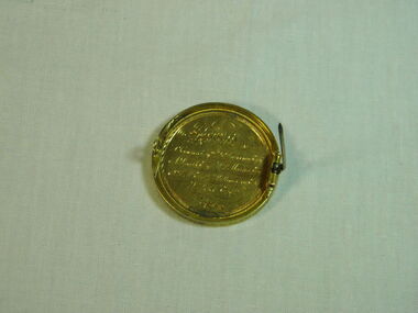
Medal, 1869 (exact); Made prior to November 1869
This medal is one of only a few medals donated by a group of generous gentlemen as tokens of their appreciation of the talent and industry of high achieving students in the years 1869 - 1870. The medal was awarded to Charles J Henderson when he completed his Matriculation Examination at the very young age of 13 years. The 1869 College annual report states that this examination, which granted entry into Melbourne University, was held in Ballarat for the first time in 1869. Candidates had to pass in at least six of the nine possible subjects in order to pass. Charles Henderson (born 3/02/1856) was the eldest son of the Rev. William Henderson of St Anderw's Kirk, Ballarat, distinguished founder of Ballarat College. Charles was only the third student enrolled at Ballarat College in July 1864. The Ballarat College annual report 1869 states the medal was awarded in appreciation of his 'success in passing so creditably the Matriculation examination at the age of thirteen years'. This medal has historic significance because it dates from the first decade of the history of the College. It has social significance because the recipient was the third student enrolled at Ballarat College, the eldest son of the founder of the College. The medal is unique and is one of only a few privately donated between 1869-1870 by a group of gentlemen affiliated with the college.This gold-plated round-shaped medal has front embossed with Minerva head, name of school and school motto. The rear of the medal is inscribed with names of medal donors. There is a straight metal pin hinged to the right side of the rear of the medal. There is a small catch attached to left side of the rear of the medal. The side edge of the medal is inscribed with name of the recipient and title of the award. The medal is housed in a rectangular cardboard box and nestled in cotton wool.The box has a blue lid and white base.Embossed around inner edge of medal front "Studiis Claritudo Venit. Ballarat College". Inscribed on rear of medal 'Presented by T. Cowan Esq.. G. Duncan Esq.. / A. Smith Esq.. W. P Martin Esq.. / J. Bell Esq..J. williamson Esq.. / S. Pike Esq..'; Maker's mark stamped below rear side inscription 'J.T.S'. Inscribed around circumference of medal 'C. J Henderson Matriculation Examination, Nov 1869'.medal, minerva, matriculation, 1869, c j henderson, thomas cowan, james willliamson, gilbert duncan, adam smith, w p martin, john bell, s pike, matriculation examination, gold medal, ballarat college school motto, ballarat college, school motto, studiis claritudo venit -
 Ballarat Clarendon College
Book, George Routledge and Sons, The Crofton boys
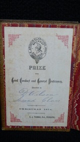
Book prize awarded to David Wilson (1885) for excellence in conduct and general proficiency. Book donated back to school after purchase in a junk shop. Handwritten inscription reveals details of family tree. Significant to the school social history because it was awarded by F J Thomas who led the school for a brief period during 1874 - 1875 and left under undignified circumstances (see Mein's history p. 19). Small calf bound novel with gold detailing on covers and spine; college crest embossed on front cover; marbled endpapers; colour frontispiece with interleave; book plate on front cover verso.Book plate inside front cover: College crest / Prize / for / Good conduct and general proficiency / awarded to / D Wilson / Second class / Chrostmas 1874 / F J Thomas BA, Principal. Handwritten inscription on back of title page: To Alexander (Lal) Wilson (my Godson) from your Uncle Alex Wilson as a keepsake from your father David Wilson, who pressed me to take a book from the first collection of books acquired from your grandfather David Wilson of the (?) Hall Hotel, Armstrong St Ballarat. But as (?) knew he had attended this school and that it was his own merited book received as a prize. I took it in preference to any other of the (?) books he offered me. This gift (/) just previous to his passing away and it was the last time I was priveledged (sic) to see him alive. It might interest you and yours to know that he died as a Christian Gentleman. I have that on the word of the Rev Frank (Menzies?), presbyterian Minister. Being sent by favour of Stewart Wilson. f-j-thomas, ballarat-college. book-prize, 1874, david-wilson -
 Ballarat Clarendon College
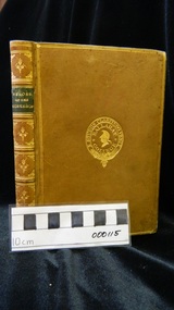
Book, C L Brightwell, Heroes of the laboratory and the workshop, Preface dated 1859
Prize awarded to James Cleeland Shaw (BD 15/10/1862) for excellence in conduct and general proficiency. James entered Ballarat College 1870. Son of Mr. W.H.Shaw the Managing Director of the celebrated Phoenix Foundry which played such an important part in the early industrial history of Ballarat and who lived all his Ballarat life in a house in Armstrong Street South not far from Dana Street. Born in Ballarat on 15th October 1862 and attended Ballarat College 1870-1877. Was articled to Hardy and Madden of Ballarat Solicitors. Practised as a Solicitor in Ballarat for some years. Went to Western Australia in 1897 and acted for a time as Deputy Master of Western Australia Supreme Court. Was for some time partner with Drake Brockman now a judge but latterly practised as Shaw and Shaw in partnership with his brother Frank as Solicitors at 81 St. Georges Terrace, Perth, Western Australia. Example of prize ordered from London where they were specially bound and embossed with the College crest. Awarded by F J Thomas B A, principal under unusual circumstances 1874 - 1876.Preface dated 1859. A clean crisp book of 222 clean unmarked pages . 22 chapters, each dealing with a separate subject including; Berthollet - chemist; James Brindley - originator of canal navigation; Graham & Breguet - watch & clock makers; & Vaucanson - automata. Firmly bound in light brown calf with six compartments between raised bands and gilt title & decorations on the spine ; gilt school crest on the front; marbled end pages and edges.Book plate inside front cover: Ballarat College crest / PRIZE / FOR / Good Conduct and General Proficiency / Awarded to / Master J Shaw / Fifith Class / Christmas 1975 / F J Thomas B A Principalf-j-thomas, ballarat-college, james-shaw, 1875, book-prize -
 Ballarat Clarendon College
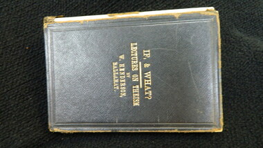
Book, McHutchison & Campbell, If, & what? : twelve lectures on the foundations of christian theism, 1882
Part of a collection obtained by K C Hofmaier 1963 by purchase of a library at gembrrok (Vic) which contained a number of books from the old Ballarat german language library with school text books and theological works formerly the property of the founder of Ballarat College Rev'd Wm Henderson. William Henderson was Minister of St Andrews Kirk at the time of writing. The very strong Presbyterian roots of Ballarat College were a legacy of this man. Socially significant for school community because of its authorship - William Henderson founded ballarat College. Black calf binding with damaged spine; gold lettering on front cover; dark green endpapers; gilt page edges;Handwritten inscription on front endpaper: by Wm Henderson / founder of Ballarat College Handwritten inscription on back of endpaper: Collected by K C Hofmaier 1963 by purchase of a library at gembrrok (Vic) which contained a number of books from the old Ballarat german language library with school text books and theological works formerly the property of the founder of Ballarat College Rev'd Wm Henderson.william-henderson, keith-hofmaier, 1882, ballarat-college, theology.