Showing 622 items
matching victoria border
-
 Wodonga & District Historical Society Inc
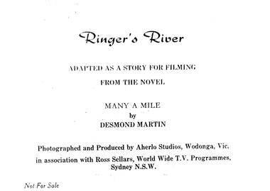
Album - Ringer's River by Des Martin - Cast, Credits & Introduction
Des Martin lived all his life in Wodonga, except for his years of service during World War Two. He was raised on the family property Aherlo in the Huon Creek Valley. In 1937 he joined the 8th Light Horse Regiment but in May 1940 led his Wodonga Troop into the 2/2nd Australian Pioneer Battalion, which saw service in Syria, Java, New Guinea and Borneo. After the war, Des returned to Aherlo and his horses. He was granted permission by the Victorian Racing Club to participate as an amateur “gentleman” rider. He was a founder of the Victorian Amateur Riders Association and also the Murray Valley Hunt Club, for which he was Master for 21 years. He was a prolific writer, cartoonist, photographer and poet, contributing to The Border Morning Mail, The Age, and the Herald and Weekly Times amongst other publications. Des Martin’s other literary works included Australia Astride (1959), A Tale of Twin Cities, Part One (1981) and Backing up the Boys (1998). In 1976, Des wrote an historical novel, “Many a Mile”, based on a fictional region which highly resembled the Albury-Wodonga and Upper Murray area of Victoria. It was set in the last 10 years leading up to Federation. Throughout this period tensions (caused by fluctuating border duties, including an infamous impost on cattle and horses) occasioned the intermittent posting of heavily armed police detachments along the River Murray. Des also wrote eight 50-minute scripts from “Many a Mile” as a television series and were presented to Michael Pate, one of Australia’s leading actors and producers. Also, funding was sought through the Australian Broadcasting Commission ... unfortunately the series never came to fruition. This album is a pictorial precis, including photos and scene descriptions, created to promote the concept of the series and have it produced locally in North Eastern Victoria featuring local settings, skilled horsemen and actors. It was to be called “Ringer’s River” ... Ringer being the title accorded to either a top cattle hand, or the fastest shearer in the wool shed. Des Martin died on 12th April 1995.These albums and images are significant because they document literature written by a prominent member of the Wodonga community. The presentation of this precis was supported by several significant district families and individuals.Documents written to introduce the concept of "Ringer's River" to gain interest for the development of a television seriesdes martin, many a mile, ringer's river, northeast victoria stories -
 Wodonga & District Historical Society Inc
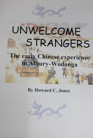
Book - UNWELCOME STRANGERS The early Chinese experience in Albury-Wodonga, Howard C Jones, 2017
Explores a time of particular hardship for Chinese men crossing the Murray at Albury-Wodonga in the 19th century. It describes the cruelties inflicted on the Chinese by both Victoria and New South Wales at the Murray because it was a colonial border.non-fictionExplores a time of particular hardship for Chinese men crossing the Murray at Albury-Wodonga in the 19th century. It describes the cruelties inflicted on the Chinese by both Victoria and New South Wales at the Murray because it was a colonial border.chinese migrants, albury, wodonga -
 Wodonga & District Historical Society Inc
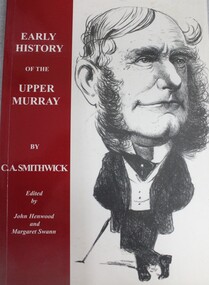
Book - Early History of the Upper Murray, C. A Smithwick, 2003
A collection of 17 articles originally published as stories in The Border Morning Mail. Stories of pioneer life, together with photos of people and places associated with the early history of the Upper Murray.non-fictionA collection of 17 articles originally published as stories in The Border Morning Mail. Stories of pioneer life, together with photos of people and places associated with the early history of the Upper Murray.frontier and pioneer life -- murray river region, murray river region, pioneers victoria -
 Wodonga & District Historical Society Inc
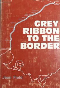
Book - Grey Ribbon to the Border, Jean Field, 1973
A detailed description of towns and area adjacent to the Hume Highway between Melbourne, Victoria and Albury, NSWnon-fictionA detailed description of towns and area adjacent to the Hume Highway between Melbourne, Victoria and Albury, NSWvictoria. countryside adjacent to the hume highway., description and travel victoria, hume highway victoria -
 Wodonga & District Historical Society Inc
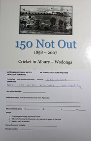
Book - 150 Not Out 1858 - 2007 Cricket in Albury Wodonga, Joe Wooding, 2007
A thoroughly researched book on the history of cricket in Albury from the first organised game of cricket played in Albury in February 1859. It features many great names of cricket with details of some of the games in which they participated. The book includes many interesting anecdotes about the life and times of the region.non-fictionA thoroughly researched book on the history of cricket in Albury from the first organised game of cricket played in Albury in February 1859. It features many great names of cricket with details of some of the games in which they participated. The book includes many interesting anecdotes about the life and times of the region.albury border cricket association, cricket history albury nsw, cricket history wodonga victoria, country cricket -
 Wodonga & District Historical Society Inc
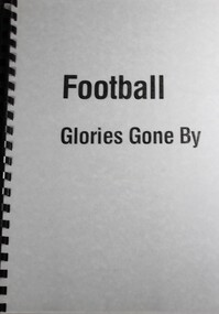
Booklet - Football Glories Gone By, Strad Jones, C. 1940
Handwritten information from the Strad Jones collection. Detailed explanation of the formation of Australian Rules football leagues and competition in Northeast Victoria. It provides information about key families in the Rutherglen area as well as other clubs in what became the Ovens and Murray Football League. Basic rules of football at the time are explained in the introduction. Details of meetings, games and game data, key events and premiership and medal winners are included. Covers period from 1890 to 1940. Clubs referenced in this publication include the initial members of Lake Rovers, Excelsior, Chiltern, Howlong, Corowa, Barnawartha and Border United. Member clubs changed over this period with the inclusion of Beechworth, Wodonga, Wangaratta and Benalla at different stages.Spiral bound containing hand written record and informationnon-fictionHandwritten information from the Strad Jones collection. Detailed explanation of the formation of Australian Rules football leagues and competition in Northeast Victoria. It provides information about key families in the Rutherglen area as well as other clubs in what became the Ovens and Murray Football League. Basic rules of football at the time are explained in the introduction. Details of meetings, games and game data, key events and premiership and medal winners are included. Covers period from 1890 to 1940. Clubs referenced in this publication include the initial members of Lake Rovers, Excelsior, Chiltern, Howlong, Corowa, Barnawartha and Border United. Member clubs changed over this period with the inclusion of Beechworth, Wodonga, Wangaratta and Benalla at different stages.australian rules football, football northeast victoria, ovens and murray football -
 Disability Sport & Recreation Victoria
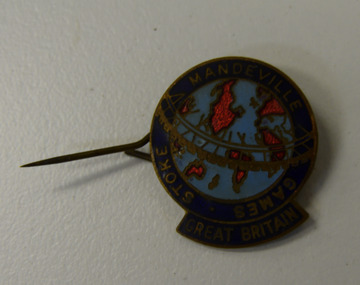
Lapel pin, Stoke-Mandeville Games - Great Britain lapel pin
Round lapel pin.Image of the map of the world, light blue oceans, bright red abstract outlines of continents. Surrounded by navy blue border with STOKE MANDEVILLE GAMES GREAT BRITAIN written in gold.stoke-mandeville games -
 Disability Sport & Recreation Victoria
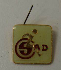
Lapel pin, SAD lapel pin
Unclear what organisation this lapel pin is representing, Small square lapel pin.Pale gold coloured silhouette of a wheelchair athlete, with a red logo spelling out "SAD" or possible "CSAD", on whitish background.and gold border -
 Disability Sport & Recreation Victoria
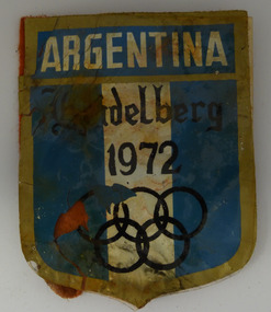
Patch, Argentina patch, Heidelberg 1972
Plastic covered, fabric backed shield patch, with metal pin mechanism on the back.The words "ARGENTINA" and "Heidelberg 1972", the latter in a Germanic style script. A black Olympic Rings motif. A blue and white stripe designed, bordered by a dark gold outline.argentina, paralympics, 1972 paralympics, heidelberg, germany -
 Falls Creek Historical Society
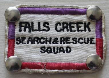
Uniform - Falls Creek Search and Rescue
The Falls Creek Search and Rescue Squad was formed in the mid 1970s. It was partly instigated by Rob Spargo whose family purchased the site where the Falls Creek Hotel is today. The family was instrumental in the establishment and growth of the Falls Creek community and were involved in the foundation of Falls Creek Primary School and Falls Creek Search & Rescue (now Falls Creek SES). Rob was also involved in the start-up of Ski Victoria and has served as a member the Chamber and Resort Management Board. The Falls Creek SES Unit was established in 1981 and includes several members who have served their community with VICSES for more than 30 years.This uniform patch represents an important safety organisation at Falls Creek.A cloth badge with metal studs at each corner. It has a border of purple and crimson machine embroidered stitching and the name of the unit is embroidered in black thread.FALLS CREEK SEARCH & RESCUE SQUADfalls creek ski patrol, skiing safety, falls creek services -
 Melbourne Legacy
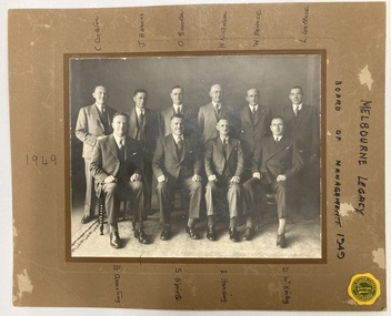
Photograph, Darge, Board of Management 1938 (labelled 1949), 1938
Members of the Legacy Club, Melbourne, Board of Management in 1938 which included Syd Birrell, Carl Carleton, Jack Barnes, Os Gawler, H Nicholson, W (Bill) Pearce, Lionel Wallace, Brian Armstrong, Eric Harding, Doug McKinlay. Another copy of this photo is labelled as being 1938 which appears to be correct as it was written and framed for presentation to J G Gillespie to commemorate his year as President. The names list around the photo may not be correct either. Second from Right is Legatee Eric Harding OBE, MM, who was also a member of the Limbless Soldiers' Association of Victoria as he lost a leg as a gunner in France in WW1. He served with the Australian Field Artillery in the original Anzac Corps. Despite loosing a leg he was active enough to ride with a Light Horse Party at the head of Melbourne's 1975 Anzac Day march. (Source Trove 18/4/1975)A record of the Board of Management of Melbourne Legacy.Black and white photo of the Board of Management mounted on brown card. Names in black pen around the border, including C Carleton, J Barnes, O Gawler, H Nicholson, W Pearce, L Wallace, B Armstrong, S Birrell, E Harding, D McKinlay. A yellow sticker of the photographer 'Darge 360 William Street Melbourne.'board of management, syd birrell, carleton, os gawler, brian armstrong, eric harding -
 Linton and District Historical Society Inc
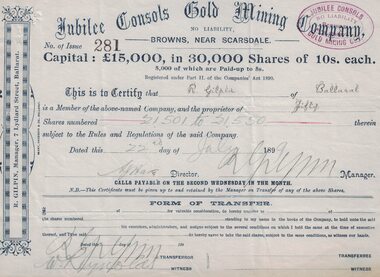
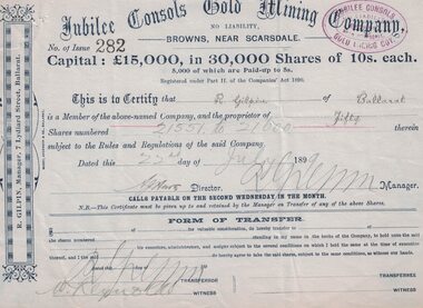
Share certificate, Berry, Anderson and Co Ballarat, Victoria, Jubilee Consols Gold Mining Company, 1899, 22 July 1899
Jubilee Consols Gold Mining Company - 50 shares for R. Gilpin of Ballarat.Blue grey paper with border on left hand side. Certifies that R. Gilpin of Ballarat is the owner of fifty shares in the Jubilee Consols Gold Mining Company at Browns, near Scarsdale. (R. Gilpin was also the manager of the company.)jubilee consols gold mining company, r. gilpin, browns [near scarsdale] -
 Linton and District Historical Society Inc
Share certificate, Berry, Anderson and Co Ballarat, Victoria, Jubilee Consols Gold Mining Company, 1899, 22 July 1899
Blue grey paper with border on left hand side.jubilee consols gold mining company, browns, gilpin -
 Stawell Historical Society Inc
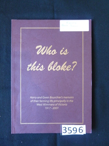
Book, Gwen & Harry Bourchier, Who is this Bloke? Harry and Gwen Bourchier's Memoirs, 2007
Burgandy Card Cover with Gold Line border and Gold PrintWho is the Bloke? Harry and Gwen Bouchier's memoirs of their farming life principally in the West Wimmera of Victoria 1917- 2007 Inside: To the Stawell Historical Society . Gwen Bouchier Gary Bouchier 2008stawell -
 Ringwood and District Historical Society
Photograph, William Maggs portrait, and photo of the Maggs home in Queensland. c1923
Black and white photographsTwo photographs. Written on back of photograph P0112(a): "The home of the late William Maggs, at The Summit, Queensland, close to the NSW border". Written on back of photograph P0112(b): "William Maggs, youngest son of the late Joseph Maggs, Mt. Dandenong Rd., Ringwood East, Victoria. -
 Bacchus Marsh & District Historical Society
Map, Plan of Land at Bacchus Marsh, the Property of James Young, 1868
James Young was a prominent businessman, land owner and public figure in the early colonial period of Bacchus Marsh. In February 1868 he offered for sale through the agent W. Anderson 38 blocks of land which ran from the Lerderderg RIver westwards beyond Gisborne Road in the vicinity of the present day Masons Land. The land for sale was described as, 'unsurpassed Agricultural Land, in the immediate vicinity of Bacchus Marsh, varying in size from 2 to 12 acres each'. The sale notice in the Bacchus Marsh Express of 1st February 1868 page 2, also noted that, ' Plans can be seen at Mr. Young's Border Mills Store, and at the Border Inn'. One of the largest and most important land sales in the early colonial period of Bacchus Marsh.A single page paper map showing 38 blocks of land for sale in 1868 in the vicinity of Masons Lane Bacchus Marsh. Scale 11 chains to 1 inch. The map is pasted into a bound volume containing 76 maps or plans in total. High resolution digital image stored on BMDHS computer network. land sales bacchus marsh, bacchus marsh victoria maps, james young 1816-1871, masons lane bacchus marsh land sales -
 Lakes Entrance Historical Society
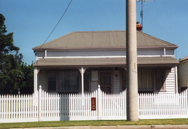
Photograph - Historic House, 1999
Believed to have been built around WW1Colour photograph of a timber dwelling at 216 marine Parade. Hipped roof with bull nose veranda of corrugated iron . Picture window bordered by narrow sash windows each side of front door, which has fan light above. White painted picket fence. Lakes Entrance Victoriahouses, heritage study -
 Bacchus Marsh & District Historical Society
Map, Main Road and Gell Street Allotments
This map shows allotments of land along Gell Street Bacchus Marsh running between Main Road (now called Main Street) and Lerderderg Street. The total area of the map encompasses Main Road, Church Street, Lerderderg Street and Gell Street. 36 allotments of land are shown. Three allotments which connect to Main Road are shaded in pink. The date of the map has not been established but the National Bank building erected in 1865 near the Border Inn is indicated which indicates that the map dates from after 1865. Reports in the Bacchus Marsh Express newspaper on 5 March 1870, page 2, column 6 announced building lots in Gell Street had been withdrawn from sale by the agent J.E. Crook. Later reports in the Express on 1 November 1873, page 2, column 2 advertised 14 allotments of land in Gell Street for sale. Single page map showing allotments of land along the Main Road (Main Street) and Gell Street areas of Bacchus Marsh. Part of a set of maps which are pasted into a bound volume containing 76 maps or plans in total. High resolution digital image stored on BMDHS computer network. bacchus marsh victoria maps, gell street land allotments, main street land allotments -
 Falls Creek Historical Society
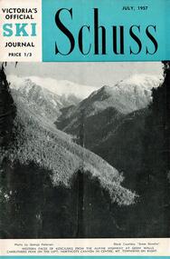
Journal - Schuss Vol. 23. No. 5 July 1957
Schuss was advertised as Victoria’s Official Ski Journal It was issued monthly from 1935 to 1961 except during the war when summer issues covered two months. This continued after the war, but it averaged 10 issues annually over its 25 year life. Schuss was published by the Ski Club of Victoria which had a membership of 38 Ski Clubs and demanded to be recognised as the prime authority on skiing in the state. The other 30 ski clubs with 85% of the members disagreed and the politics of skiing became heated. These clubs formed the Federation of Victorian Ski Clubs with their own journal, Ski Horizon. With the establishment of the Victorian Ski Association, Ski-Horizon published its last issue in Nov - Dec. 1955 and the role of the official journal was fully taken over by “Schuss”. This item is significant because it contains stories, images and information documenting the development of the ski facilities at Falls Creek.The journal features stories and events chronicling developments in Victoria and internationally. In this issue:- Page 173 features a report from the Border Morning Mail (Albury) announcing the opening of a new Comfort Station at Falls Creek. Falls Creek is also to have a reticulated village water supply Page 187 in Falls Creek Notes gives greater detail on the opening of the Comfort Station, as well as events to be held in September for Schoolgirls and Schoolboys. The transport provided for skiers by Bob Hymans and Cecil Dobson is also praised. Page 189 advertises two job vacancies at Grand Coeur Chalet.schuss journal, the ski club of victoria, grand coeur chalet, cecil dobson, bob hymans -
 Victorian Railway History Library
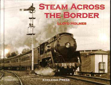
Book, Holmes, Lloyd, Steam Across The Border, 2012
A history of the cross border railway at Wodonga-Albury between Victoria and New South Wales.ill, maps, p.72.non-fictionA history of the cross border railway at Wodonga-Albury between Victoria and New South Wales.railroad operations - australia - history, rail gauges - australia - history -
 Melbourne Royal
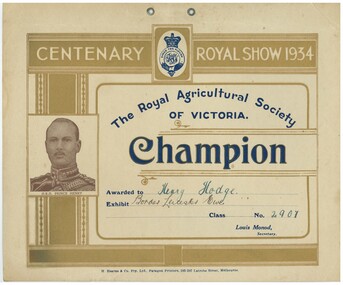
Award - Certificate, H. HEARNE AND CO, 1934
The Centenary Royal Show in 1934 was held in honour of one hundred years since the city of Melbourne was established 1834. The Show was opened by HRH Prince Henry, pictured on the certificate. A landscape card with gold, blue, and light purple text and images printed, plus handwriting in ink.CENTENARY ROYAL SHOW 1934 / [in logo] SPEED THE PLOUGH / The Royal Agricultural Society / OF VICTORIA / Champion / Awarded to [handwriting] Henry Hodge. / Exhibit [handwriting] Border Leicester Ewe / Class No [handwriting] 2907 / Louis Monod, / Secretary. / H Hearne & Co. Pty. Ltd., Paragon Printers, 285-287 Latrobe Street, Melbourne. / [image caption] H.R.H. PRINCE HENRYmelbourne royal show, 1934 melbourne royal show, centenary melbourne show, centenary royal show, monarchy, hrh prince henry, hodge, henry hodge, border leicester, sheep, border leicester sheep, monod, louis monod, prize, winners -
 Wodonga & District Historical Society Inc
Photograph - Bethanga Bridge
The Bethanga Bridge was built between 1927 and 1930 as a joint venture between Victoria and New South Wales and was a key element of the River Murray Waters Agreement. It consists of nine spans of 82 metres long. Each span is supported between double reinforced concrete pylons and a riveted steel camel back Pratt truss. The overall span of the bridge is a length of 752 metres. It was completed in 1929 at a cost of £194,000. The road deck was initially constructed from timber but was replaced in 1961 with a concrete waffle slab deck 7.7metres wide. In 1961 the bridge deck and truss structure were raised 300 millimetres to allow for the enlargement of the lake. The bridge was designed in NSW by road engineer Percy Alan and the trusses were built by the Charles Ruwolt Pty. Ltd. Charles Ruwolt Pty. Ltd. was originally established by Charles Ruwolt as a foundry at Wangaratta in 1902 and transferred its operations to Richmond, Melbourne in 1914. By 1938 it had become one of the biggest engineering companies in Australia. After Charles Ruwolt’s death in 1946, Vickers Ltd. acquired the company and in 1948 the firm became known as Vickers Ruwolt Pty. Ltd. Because of the Bethanga Bridge’s unique location, over the waters of a dam with the border running down the centre of the body of water, the Bethanga Bridge is the only built structure shared by both Victoria and New South Wales. As the border of New South Wales aligns with the southern bank of the Murray River all of the other bridges along its length are deemed to be in New South Wales. The Bethanga Bridge is listed on both the New South Wales State Heritage Register and the Victorian Heritage Database. In 2015 the Bethanga Bridge was nominated for a heritage award by the Institution of Engineering Australia.These images are significant because they document the construction of a bridge which links Victoria and New South Wales and has been recognised for its historical, technical and engineering significance.A collection of photos documenting the construction of the Bethanga Bridge which links the States of Victoria and New South Wales as part of the construction of the Hume Dam .bethanga bridge, hume dam constuction, charles ruwolt, percy allan engineer -
 Stawell Historical Society Inc
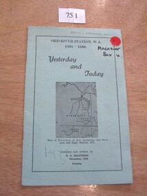
Book, N.A. McLennan, Yesterday and Today - Ord River Station WA 1895 - 1896 by N A McLennan, 1965
John McLennan's Period as Manager of the Ord River Station. W.A. adjoining Negri Station N.T., was 1895-6. The whole area consisted of 3,365,000 areas under a number of leasesand the then owner was Mr W.H. Osmand, who lived at "The Sycamores" four miles east of Stawell in Victoria. The Distance to Ord W.A. is 4,000 Miles.LIght green card cover with border, inside print and picture of a map Ord River Station W.A. 1895-1896 Yesterday and Today Map of North-East of W.A. Kimberly Ord River area Negri Station N.T. Complied and written by N.A. McLennan December 1965 1965 Victoriastawell, mclennan family -
 Stawell Historical Society Inc
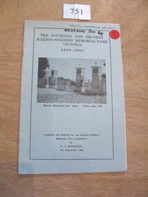
Book, N.A. McLennan, The Founders and Records, Marnoo Soldiers Memorial Park Victoria 1919 - 1965 by N A McLellan, 1965
About the founding of the Marnoo Soldiers' Park. THe Meaning of Marnoo, where Is Marnoo?, and the People involved.Pale blue Card with black Border inside of which is black text and b/w of a iron gate and four stone pillars.The Founders and records Marnoo Soldiers' Memorial Park Victoria 1919 -1995 Marnoo Memorial Park Gates Photo Taken 1963 Complied and written for the Marnoo Soldiers' Park Committee. by N.A. McLennan 9th September, 1965stawell ww1 ww2, mclennan family -
 Stawell Historical Society Inc
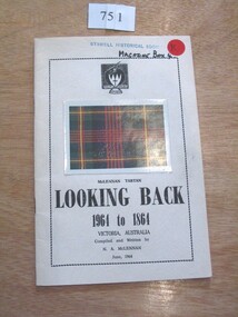
Book, N.A. McLennan, Looking Back 1964 to 1864 by N A McLennan, 1964
This booklet contains records, mostly of the McLennans, perhaps more about John McLennan than others, as he seemed to be the only one who left any records of the past.yellow card with border Family Crest? with Latin Colour card showing a Tartan above black text(In Latin [ Dum Spero Spiro]) McLennan Tartan Looking Back 1964-1864 Victoria, Australa compiled and written by N.A. McLennan June 1964stawell, mclennan family -
 Wooragee Landcare Group
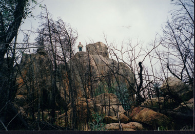
Photograph, circa April 2003
This photograph was taken in the Mount Pilot Chiltern National Park. This park is located near Chiltern in Victoria. It's most notable landmarks include Mt Pilot and Woolshed Falls. It also has many mines from the Gold Rush in the late 1800s. It is home to much flora and fauna, including the tiger quoll. The tiger quoll, also known as the spotted-tail quoll, is a marsupial that gives in the Mount Pilot Chiltern National Park. It is also main land Australia's largest carnivorous marsupial. It can weigh up too four kilograms and looks similar to either a possum or a spotted cat. It has red and brown fur with distinct spots. The tiger quoll is found along the Great Dividing Range, which includes Victoria, New South Wales and also near the border of Queensland. It lives in forests, rainforests and coastal heathlands and woodlands. In 2004 a team of volunteers from the Wooragee Landcare group as well as some of the Department of Sustainability and Environment staff set out to find the tiger quoll following the 2003 bushfires. Since the bushfires, concern had arisen for it because it hadn't been seen since the bushfires. They attempted to find traces of the quoll through finding and identifying their droppings as well as DNA testing. This photograph was taken during this search. This photograph represents the work that goes into protecting a important species like the tiger quoll. The tiger quoll is a significant species because it is main land Australia's largest carnivorous marsupial. As a result of this, there has been much work done to preserve and protect it. This photograph was taken when the Wooragee Landcare group went to ensure the survival of this species, highlighting how the tiger quoll is being protected. This photograph also demonstrates the impacts of the 2003 bushfires in the Mount Pilot Chiltern National Park. This is seen through the burnt trees featured in the picture. Landscape coloured photograph printed on gloss paperReverse: WAN NA 0ANA0N0 NNN 0 1636 / [PRINTED] (No.7) / 921quoll, mount pilot chiltern national park, national park, 2003 bushfires, search, endangered, beechworth, wooragee landcare group, wooragee landcare, wooragee, possum, australia, victoria, department of sustainability and environment, photograph, 2004, spotted-tailed quoll, great dividing range, spots, fur, forests, rainforests, woodlands, coastal heathlands, spotted quoll, spotted quoll habitat -
 Buda Historic Home & Garden Castlemaine
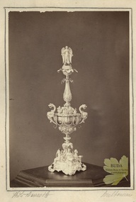
Photograph, Leviny Silver Standing Cup, c1863
The Silver Standing Cup was made by Ernest Leviny c1860 and presented to Mr Charles Abraham Saint, editor of the Mount Alexander Mail newspaper, by the town's citizens on his departure from Castlemaine on 31 December 1863. Mount Alexander Mail report; 23 January 1864. This substantial silver centrepiece was the second masterpiece created by Ernest Leviny around 1859. It is decorated with highly detailed cast figures, fine embossing and chasing. This work of Australian Colonial significance reflects Leviny's rich European artistic background which he successfully merged with new Australian motifs, which epitomise the great wealth, ambition and pride at that time in the emerging, young Colony of Victoria.Semi matt surface albumen print mounted on cream coloured card with border around image drawn in pencil. Albumen photograph of Silver Standing Cup (Eperne). Elaborate silver cup, with lid highly decorated with cast figures, etc.Handwritten in pencil under image: I.1 'Photo Davies & Co' I.r 'Melbourneernest leviny, silver, silversmithing, cup, london exhibition 1862, mount alexander mail, william davies, photograph, charles a. saint -
 Warrnambool and District Historical Society Inc.
Booklet - Warrnambool Visitor's Handbooks 1979-2024, Collett, Bain and Gaspar, Printers, 1979-2014
This is a collection of eight Warrnambool Visitor handbooks produced between 1979 and 2014 by the City of Warrnambool Tourist Information Centre. They contain maps of Warrnambool, lists of services, accommodation and tourist attractions as well as many advertisements for local businesses.These handbooks give a useful snapshot of businesses and tourist attractions in Warrnambool for each of the years covered. (1979, 1980, 1986, 1990, 1993, 1994, 1995, 2014)[.1a] A 48 page booklet with white pages and blue printing. The front cover has a coloured photograph of Flagstaff Hill with boats on a man made lake in the foreground looking across Lake Pertobe toward South Warrnambool. [.1b] A coloured bifold brochure. The front cover has a fisherman on a cray-boat holding a crayfish in the lower section. The top quarter has a blue back ground with white printing. The rear cover is red and has small photos of the Hopkins River and the Framlingham Forest. [.2] A 48 page booklet with white pages and black printing. The front cover is white with black writing on the left hand side and a colour photograph of the Loch Ard peacock. The Warrnambool Premier Town stylised logo of seven Norfollk pines above blue waves is in the top right hand corner. There is a blank ink Warrnambool Library stamp underneath the logo. The rear cover has photographs of The Twelve Apostles and the Hopkins Falls and the Premier Town Logo [.3] A 40 page booklet with mainly black printing on white paper. There are three fold out maps of Warrnambool and the surrounding district. The glossy cover has a black background with a colour photograph of the Twelve Apostles taken at sunset. The rear cover has three small of Proudfoot's boathouse on the Hopkins River, Flagstaff Hill, and the main beach area. The front cover has black writing inside to peach coloured rectangles. The inside rear cover has a fold out coloured tour map of Western Victoria. [.4] A 40 page booklet printed on glossy white paper with coloured photographs and black and red printing. The front cover has a photograph of The Twelve Apostles surrounded by a white border. There is red writing in the upper border. There is a sandy coloured writing superimposed across the bottom of the photograph and a Victoria's Shipwreck Coast logo in the bottom right hand corner. [.5] A 44 page booklet printed on white paper with black printing. The cream coloured cover has a pale red rectangle with blue writing on the right hand facing edge and includes two stylised Norfolk pines and with waves underneath. There is is an intersecting blue rectangle with cream printing. [.6] A 48 page booklet printed on white paper with black printing. The cover is brown with a cream vertical strip containing black writing on the right hand side. There is a stylised map from Geelong to Mount Gambier showing the Great Ocean Road across the cover. [.7] A 48 page booklet printed on white paper with black print. The glossy colour cover has a photograph of a Southern Right whale fluke. There is white printing on a the blue background of the sky and sea. The bottom left hand side of the front cover has a Tourism Victoria logo made of jigsaw puzzle pieces. The back cover has a stylised coloured map of The Great Ocean Road located in a white rectangle at the top of the page. Within the rectangle is a small map of Australia locating Victoria and the part of Victoria covered by the map. [.8] A 64 page A5 coloured booklet printed on white pages with black print. The white front cover has black and grey print with a colour photograph of two people holding coffee cups watching four race horses being exercised on the beach and in the water of Lady Bay in the early morning. The bottom right hand corner has a Tourism Victoria logo. The rear cover has a mainly blue back ground with a pink orange and green colour splats contains words advertising the 2015 Fun 4 Kids Festival [.1a] Warrnambool The Heart of Victoria's Great Southwest Visitor's Handbook [.1b] Warrnambool City for all seasons; The Heart of Victoria's Great Southwest [.2] Warrnambool visitor's handbook Warrnambool Premier Town 1979-1982 [.3] Warrnambool Handbook Victoria [.4] Warrnambool The Shipwreck Coast [.5] Welcome to Warrnambool Warrnambool Visitors Handbook 1993-1994 [.6] Welcome to Warrnambool Visitors Handbook 1994-95 Rear cover: Warrnambool Centre of Victoria's Shipwreck Coast on Australia's Great Ocean Road [.7] Warrnambool Shipwreck Coast - Great Ocean Road; You'll love every piece of Victoria; Visitors Handbook [.8] Warrnambool Great Ocean Road Official Visitor Guide; It's a wonderful Warrnambool; You'll love every piece of Victoria visitvictoria.com. Rear Cover Live entertainment.Workshops.Creativity.Action 28 June - 5 July 2015 Australia's Best Children's Festival F4K The ultimate winter school holiday adventure Fun 4 kids festival Warrnambool For more information visit Fun4kids.com.au Warrnambool great Ocean Road Victoriawarrnambool, visitor handbooks, tourist information guides, warrnambool maps -
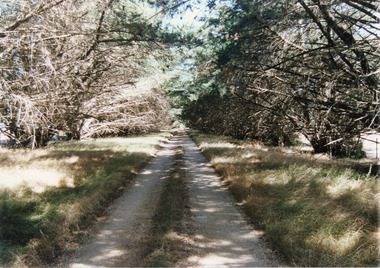 Lakes Entrance Historical Society
Photograph, Tambo Shire, 1994 c
Also second identical copyColour Photograph of a typical farm driveway, shows a long driveway bordered with cypress trees. Nicholson Victoriaroads and streets -
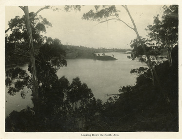 Lakes Entrance Historical Society
Postcard - North Arm, Bulmer H D, 1930c
Black and white large format postcard of a broad reach of the North Arm, showing the calm waters of the lake, natural vegetation in foreground, some land bordering lake has been cleared. Lakes Entrance VictoriaLooking down the North Armwaterways, vegetation