Showing 1477 items
matching weatherly
-
 Flagstaff Hill Maritime Museum and Village
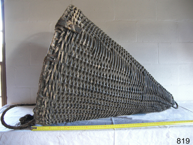
Equipment - Distant Signal, 1897-1931
This three-dimensional Distant Signal is part of a Flagstaff Signal set of ball, cone and drum shapes. It has been woven and then fabricated with strong metal swivel fittings and loops for suspending from a high point on a flagstaff at a signal station or on a ship’s masthead. The cane signal was constructed to withstand all weather and to be visible from a long distance. The gaps between the woven cane allow air to pass through, minimising possible swaying. Similar sets were made from rope or fabric. Warrnambool's Flagstaff was erected in 1854. Its primary use was to display visual signals that could convey messages between land and sea. It was also used to notify the local population of the approach of ships. One of the popular signalling codes in use in the early-to-mid 1800s was the Marryat’s Code but there were others in use as well; there was no one standard code. In 1857 the International Marine Conference adopted an International Code of Signals as a standard communications system for all vessels that could be understood in many different languages. The Normanby Advertiser reported on June 5th 1857 a query from the Post Master General as to whether the request of the Chief Harbour Master would be carried out, in that Warrnambool would receive a new flagstaff and a set of Marryatt’s signal flags. The Table of Codes was published, showing how to use combinations of these flags to send messages. The Code was revised in 1887 to cover situations where distance, light, wind and weather conditions affected the visibility of the flags and prevented clear communication. The first report of the International Code of Signals Committee of 1897 warned signalmen not to rely on ordinary semaphore flags and introduced a Distant Signal Code using either particular semaphore flags or the three-dimensional shapes of a ball, cone and drum that aligned with the semaphore flag shapes of a circle, pennant and square. International Code of Signals In 1931, after World War I’s experiences in using signal codes, the International Code of Signals conference in Washington revised and published the rules for the conduct of signalling. One of the changes was that “the use of the Distant Signals and of fixed semaphore was abandoned”. It is of interest to know that modern marine law in many countries insists that a set of Day Shapes must be carried onboard vessels of a certain size. These highly visible geometric shapes are used at sea in daylight to communicate messages between vessels. They are used in a similar way to the Distant Signals, in that different combinations of shapes represent different messages. The set of shapes includes a ball, cylinder, cone and diamond. The shapes are hung between the top of the vessel’s foremast and the front of the vessel. They are only coloured black and are about 1.5 metres high. The vertical line of shapes can mean messages such as Boat not under command, Fishing, and Under sail and power.Distant Signals were an important means of marine communication from the late 1880s to the early 1930s, including during World War I. They were an advancement to the International Shipping Codes and safety. The cane signals’ shapes appear to be the same from whatever direction they are viewed, removing confusion about the message they convey. The same shapes continue to be used today for the sets of Day Shapes used as marine navigational signals that are mandatory on certain-sized vessels.Distant Signal Cone, part of a Flagstaff signal set. A woven cane cone, painted black, with a metal rod passing through the centre and two crossed metal bars at the base. The central rod has a loop at the top and passes through the bars at the base, finishing in a metal loop. The rod has swivels at each end.flagstaff hill, warrnambool, flagstaff hill maritime museum and village, shipwreck coast, marine navigation, marine communications, communication signal, lifesaving, ship at sea, day shape, masthead signal, day signal, day mark signals, marine technology, safety equipment, navigation equipment, marine day shape, day marker, cane day shape, signal cone, day signal cone, cone signal, cone day shape, distant signal, flagstaff signal, signal station, communications, signals, marine signals, flaghoists, international marine conference, international code of signals, signal codes, marine safety, signal flags, daymark, day symbol, navigation, warrnambool flagstaff, 1854, 1857 1931, 1887, 1897 -
 Flagstaff Hill Maritime Museum and Village
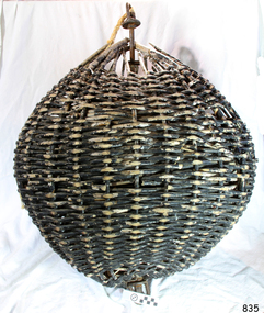
Equipment - Distant Signal, 1897-1931
This three-dimensional Distant Signal is part of a Flagstaff Signal set of ball, cone and drum shapes. It has been woven and then fabricated with strong metal swivel fittings and loops for suspending from a high point on a flagstaff at a signal station or on a ship’s masthead. The cane signal was constructed to withstand all weather and to be visible from a long distance. The gaps between the woven cane allow air to pass through, minimising possible swaying. Similar sets were made from rope or fabric. Warrnambool's Flagstaff was erected in 1854. Its primary use was to display visual signals that could convey messages between land and sea. It was also used to notify the local population of the approach of ships. One of the popular signalling codes in use in the early-to-mid 1800s was the Marryat’s Code but there were others in use as well; there was no one standard code. In 1857 the International Marine Conference adopted an International Code of Signals as a standard communications system for all vessels that could be understood in many different languages. The Normanby Advertiser reported on June 5th 1857 a query from the Post Master General as to whether the request of the Chief Harbour Master would be carried out, in that Warrnambool would receive a new flagstaff and a set of Marryatt’s signal flags. The Table of Codes was published, showing how to use combinations of these flags to send messages. The Code was revised in 1887 to cover situations where distance, light, wind and weather conditions affected the visibility of the flags and prevented clear communication. The first report of the International Code of Signals Committee of 1897 warned signalmen not to rely on ordinary semaphore flags and introduced a Distant Signal Code using either particular semaphore flags or the three-dimensional shapes of a ball, cone and drum that aligned with the semaphore flag shapes of a circle, pennant and square. International Code of Signals In 1931, after World War I’s experiences in using signal codes, the International Code of Signals conference in Washington revised and published the rules for the conduct of signalling. One of the changes was that “the use of the Distant Signals and of fixed semaphore was abandoned”. It is of interest to know that modern marine law in many countries insists that a set of Day Shapes must be carried onboard vessels of a certain size. These highly visible geometric shapes are used at sea in daylight to communicate messages between vessels. They are used in a similar way to the Distant Signals, in that different combinations of shapes represent different messages. The set of shapes includes a ball, cylinder, cone and diamond. The shapes are hung between the top of the vessel’s foremast and the front of the vessel. They are only coloured black and are about 1.5 metres high. The vertical line of shapes can mean messages such as Boat not under command, Fishing, and Under sail and power.Distant Signals were an important means of marine communication from the late 1880s to the early 1930s, including during World War I. They were an advancement to the International Shipping Codes and safety. The cane signals’ shapes appear to be the same from whatever direction they are viewed, removing confusion about the message they convey. The same shapes continue to be used today for the sets of Day Shapes used as marine navigational signals that are mandatory on certain-sized vessels.Distant Signal Ball, part of a Flagstaff signal set. A round woven cane ball, painted black, with a metal rod passing through the centre. The rod has a loop at each end, then a concave, octagonal metal plate that rests on the outside surface of the ball, serving as a washer. The rod has swivels at each end.flagstaff hill, warrnambool, flagstaff hill maritime museum and village, shipwreck coast, marine navigation, marine communications, communication signal, lifesaving, ship at sea, day shape, masthead signal, day signal, day mark signals, marine technology, safety equipment, navigation equipment, marine day shape, day marker, cane day shape, signal ball, day signal ball, ball signal, ball day shape, distant signal, flagstaff signal, signal station, communications, signals, marine signals, flaghoists, international marine conference, international code of signals, signal codes, marine safety, signal flags, daymark, day symbol, navigation, warrnambool flagstaff, 1854, 1857 1931, 1887, 1897 -
 Flagstaff Hill Maritime Museum and Village
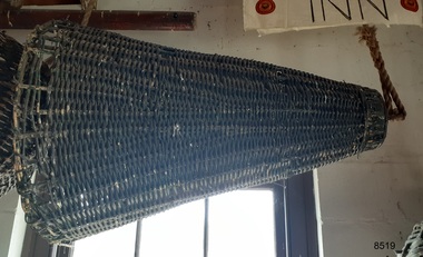
Equipment - Distant Signal, 1897-1931
This three-dimensional Distant Signal is part of a Flagstaff Signal set of ball, cone and drum shapes. It has been woven and then fabricated with strong metal swivel fittings and loops for suspending from a high point on a flagstaff at a signal station or on a ship’s masthead. The cane signal was constructed to withstand all weather and to be visible from a long distance. The gaps between the woven cane allow air to pass through, minimising possible swaying. Similar sets were made from rope or fabric. Warrnambool's Flagstaff was erected in 1854. Its primary use was to display visual signals that could convey messages between land and sea. It was also used to notify the local population of the approach of ships. One of the popular signalling codes in use in the early-to-mid 1800s was the Marryat’s Code but there were others in use as well; there was no one standard code. In 1857 the International Marine Conference adopted an International Code of Signals as a standard communications system for all vessels that could be understood in many different languages. The Normanby Advertiser reported on June 5th 1857 a query from the Post Master General as to whether the request of the Chief Harbour Master would be carried out, in that Warrnambool would receive a new flagstaff and a set of Marryatt’s signal flags. The Table of Codes was published, showing how to use combinations of these flags to send messages. The Code was revised in 1887 to cover situations where distance, light, wind and weather conditions affected the visibility of the flags and prevented clear communication. The first report of the International Code of Signals Committee of 1897 warned signalmen not to rely on ordinary semaphore flags and introduced a Distant Signal Code using either particular semaphore flags or the three-dimensional shapes of a ball, cone and drum that aligned with the semaphore flag shapes of a circle, pennant and square. International Code of Signals In 1931, after World War I’s experiences in using signal codes, the International Code of Signals conference in Washington revised and published the rules for the conduct of signalling. One of the changes was that “the use of the Distant Signals and of fixed semaphore was abandoned”. It is of interest to know that modern marine law in many countries insists that a set of Day Shapes must be carried onboard vessels of a certain size. These highly visible geometric shapes are used at sea in daylight to communicate messages between vessels. They are used in a similar way to the Distant Signals, in that different combinations of shapes represent different messages. The set of shapes includes a ball, cylinder, cone and diamond. The shapes are hung between the top of the vessel’s foremast and the front of the vessel. They are only coloured black and are about 1.5 metres high. The vertical line of shapes can mean messages such as Boat not under command, Fishing, and Under sail and power.Distant Signals were an important means of marine communication from the late 1880s to the early 1930s, including during World War I. They were an advancement to the International Shipping Codes and safety. The cane signals’ shapes appear to be the same from whatever direction they are viewed, removing confusion about the message they convey. The same shapes continue to be used today for the sets of Day Shapes used as marine navigational signals that are mandatory on certain-sized vessels.Distant Signal Cone, part of a Flagstaff signal set. A woven cane cone, painted black, with a metal rod passing through the centre and two crossed metal bars at the base. The central rod has a loop at the top and passes through the bars at the base, finishing in a metal loop. The rod has swivels at each end.flagstaff hill, warrnambool, flagstaff hill maritime museum and village, shipwreck coast, marine navigation, marine communications, communication signal, lifesaving, ship at sea, day shape, masthead signal, day signal, day mark signals, marine technology, safety equipment, navigation equipment, marine day shape, day marker, cane day shape, signal cone, day signal cone, cone signal, cone day shape, distant signal, flagstaff signal, signal station, communications, signals, marine signals, flaghoists, international marine conference, international code of signals, signal codes, marine safety, signal flags, daymark, day symbol, navigation, warrnambool flagstaff, 1854, 1857 1931, 1887, 1897 -
 Flagstaff Hill Maritime Museum and Village
Equipment - Distant Signal, 1897-1931
This three-dimensional Distant Signal is part of a Flagstaff Signal set of ball, cone and drum shapes. It has been woven and then fabricated with strong metal swivel fittings and loops for suspending from a high point on a flagstaff at a signal station or on a ship’s masthead. The cane signal was constructed to withstand all weather and to be visible from a long distance. The gaps between the woven cane allow air to pass through, minimising possible swaying. Similar sets were made from rope or fabric. Warrnambool's Flagstaff was erected in 1854. Its primary use was to display visual signals that could convey messages between land and sea. It was also used to notify the local population of the approach of ships. One of the popular signalling codes in use in the early-to-mid 1800s was the Marryat’s Code but there were others in use as well; there was no one standard code. In 1857 the International Marine Conference adopted an International Code of Signals as a standard communications system for all vessels that could be understood in many different languages. The Normanby Advertiser reported on June 5th 1857 a query from the Post Master General as to whether the request of the Chief Harbour Master would be carried out, in that Warrnambool would receive a new flagstaff and a set of Marryatt’s signal flags. The Table of Codes was published, showing how to use combinations of these flags to send messages. The Code was revised in 1887 to cover situations where distance, light, wind and weather conditions affected the visibility of the flags and prevented clear communication. The first report of the International Code of Signals Committee of 1897 warned signalmen not to rely on ordinary semaphore flags and introduced a Distant Signal Code using either particular semaphore flags or the three-dimensional shapes of a ball, cone and drum that aligned with the semaphore flag shapes of a circle, pennant and square. International Code of Signals In 1931, after World War I’s experiences in using signal codes, the International Code of Signals conference in Washington revised and published the rules for the conduct of signalling. One of the changes was that “the use of the Distant Signals and of fixed semaphore was abandoned”. It is of interest to know that modern marine law in many countries insists that a set of Day Shapes must be carried onboard vessels of a certain size. These highly visible geometric shapes are used at sea in daylight to communicate messages between vessels. They are used in a similar way to the Distant Signals, in that different combinations of shapes represent different messages. The set of shapes includes a ball, cylinder, cone and diamond. The shapes are hung between the top of the vessel’s foremast and the front of the vessel. They are only coloured black and are about 1.5 metres high. The vertical line of shapes can mean messages such as Boat not under command, Fishing, and Under sail and power.Distant Signals were an important means of marine communication from the late 1880s to the early 1930s, including during World War I. They were an advancement to the International Shipping Codes and safety. The cane signals’ shapes appear to be the same from whatever direction they are viewed, removing confusion about the message they convey. The same shapes continue to be used today for the sets of Day Shapes used as marine navigational signals that are mandatory on certain-sized vessels.Distant Signal Ball, part of a Flagstaff signal set. A round woven cane ball, painted black, with a metal rod passing through the centre. The rod has a loop at each end, then a concave, octagonal metal plate that rests on the outside surface of the ball, serving as a washer. The rod has swivels at each end.distant signal, flagstaff signal, signal station, masthead signal, communications, marine technology, signals, marine signals, flaghoists, international marine conference, international code of signals, signal codes, marine safety, signal flags, day shape, daymark, day symbol, navigation, warrnambool flagstaff, 1854, 1857 1931, 1887, 1897 -
 Falls Creek Historical Society
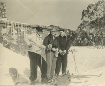
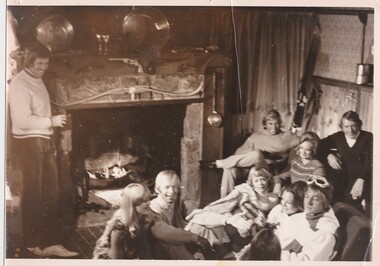
Photograph - Bogong Trip 1951- At Cleve Cole Lodge
MEYER COLLECTION - FALLS CREEK PHOTOS In 1947 a determined group of like-minded State Electricity Commission (SEC) staff including Ray Meyer, the chief surveyor of the Kiewa Hydro-Electric Scheme, had a common interest that revolved around the skiing potential of the snow-covered high plains which included what is now the resort of Falls Creek. The six SEC employees, Toni St Elmo, Ray Meyer, Jack Minogue, Lloyd Dunn, Adrian Ruffenacht and Dave Gibson (together with their families) banded together to secretly build a 'hut' that was the first ski lodge at Falls Creek. Using a road built in 1930s to gain access to Falls Creek, their hut project was carried out in secret as efforts by other skiers were blocked by H.H.C. Williams – the engineer in charge of the Hydro Scheme. In 1946 Ray Meyer made a trip to the Lands Office in Melbourne. He came away with a 99-year lease on three acres that was ideally suited for a hut designed by Lloyd Dunn. Adrian Ruffenacht (Design Engineer for the KHS) had suggested where the group should build because of easy access to a spring for water. Much of the building material required was scavenged from derelict huts on the high plains. Due to the need for secrecy, the determined group worked on the hut in the evenings and weekends to avoid detection. During the building period the group had met at Echidna Rock (now known as Eagle Rock) where Skippy St Elmo announced, "This is my favourite ‘Skyline’.” And so the first lodge in the area at Falls Creek Ski Resort came into existence. With the development of the International Poma in the 1970s, the Skyline Lodge, which was sited between the ski-lift’s pole one and pole two, was demolished. However, the legacy of Ray Meyer, Toni St Elmo, Jack Minogue, Lloyd Dunn, Adrian Ruffenacht and Dave Gibson and Skyline lives on in the vibrant atmosphere of Falls Creek Resort. The MEYER COLLECTION documents developments on the Kiewa Hydro Scheme and their life at Falls Creek from the mid 1930s to 1960s.This image is significant because it depicts aspects of the life of a pioneering family of Falls Creek and the founders of "Skyline", the first lodge at Falls Creek.Black and White Images of visitors at Cleve Cole Lodge. Photo 1. L to R:- Ray Meyer, H. Gibbs and Wal Johnson. Photo 2. Ray Meyer and Wal Johnson having photo taken. CLEVE COLE HUT was built in 1937 for the Ski Club of Victoria, to commemorate pioneer skier, Cleve Cole, who died on a disastrous ski trip across the high In August 1936 three men, Cleve Cole, Mick Hull, and Howard Michell, skied from Mount Hotham across the Bogong High Plains to Mount. On reaching the mountain they became trapped for four days on the summit ridge by appalling weather conditions. For three days they followed the Big River through rough country before deciding that Howard should continue alone to find help, leaving Mick to care for Cleve who was barely able to continue. Three days later a search party, raised after Howard had reached Glen Valley, found Cleve and Mick. Within two days the group arrived at Glen Valley where, tragically, Cleve Cole died later that night. In memory of Cleve’s life and his pioneering work in the Victorian alpine country it was decided to build a refuge hut on the mountain. It is called the Cleve Cole Memorial Hut.falls creek, bogong high plains, cleve cole hut -
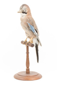 The Beechworth Burke Museum
Animal specimen - Eurasian Jay, Trustees of the Australian Museum, 1860-1880
The Eurasian Jay is a small passerine bird occurring in Europe, northern Africa, and Asia. There are very distinct variations between the species of the Jay which assists in their identification. These birds inhabit mixed woodland, parks, orchards, and large gardens. They are generally solitary but can gather in large communal roosts during periods of cold weather. Eurasian Jays are known for their mimicry. They can often sound like a different species and during the day may mimic the birds they are attacking in order to confuse their opposition. This particular specimen has been mounted in an accurate but stylised fashion. This specimen is part of a collection of almost 200 animal specimens that were originally acquired as skins from various institutions across Australia, including the Australian Museum in Sydney and the National Museum of Victoria (known as Museums Victoria since 1983), as well as individuals such as amateur anthropologist Reynell Eveleigh Johns between 1860-1880. These skins were then mounted by members of the Burke Museum Committee and put-on display in the formal space of the Museum’s original exhibition hall where they continue to be on display. This display of taxidermy mounts initially served to instruct visitors to the Burke Museum of the natural world around them, today it serves as an insight into the collecting habits of the 19th century.This specimen is part of a significant and rare taxidermy mount collection in the Burke Museum. This collection is scientifically and culturally important for reminding us of how science continues to shape our understanding of the modern world. They demonstrate a capacity to hold evidence of how Australia’s fauna history existed in the past and are potentially important for future environmental research. This collection continues to be on display in the Museum and has become a key part to interpreting the collecting habits of the 19th century.The Eurasian Jay, as depicted in this specimen, has distinctive blue, white and dark brown stipes at the top of the wing. The body and head are light brown with a reddish undertone and there are streaks of dark brown at top the head. The tail, bottom of the wings and underneath the eyes are dark brown. This particular specimen stands upon a wooden mount and has an identification tag tied around its leg. It has pale coloured glass eyes which are accurate for this species.Swing Tag: [illegible] / to Sydney - N =99taxidermy mount, taxidermy, animalia, burke museum, beechworth, australian museum, skin, bird, jay, eurasian jay, europe, european birds, blue stripes -
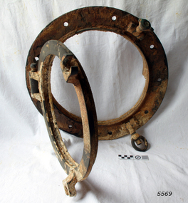 Flagstaff Hill Maritime Museum and Village
Functional object - Porthole frame, ca. 1889
This porthole and porthole cover was removed from the stern of the Newfield wreck, on the starboard side. The barque Newfield left Liverpool on 1st June 1892 with a cargo of 1850 tons of fine rock salt for Brisbane. About six weeks later the ship ran into very heavy weather approaching the Australian coast. On 28th August at about 9pm her master, Captain George Scott, observed between the heavy squalls the Cape Otway light on the mainland of Victoria, but due apparently to a navigational error (the chronometers were incorrect), he mistook it for Cape Wickham on King Island, some 40 miles south. He altered course to the north expecting to run through the western entrance of Bass Strait, but instead, at about 1:30am, the ship ran aground about about 100 yards from shore, one mile east of Curdies River. The vessel struck heavily three times before grounding on an inner shoal with six feet of water in the holds. The Newfield remained upright on the reef with sails set for a considerable time as the wind slowly ripped the canvas to shreds and the sea battered the hull to pieces. Seventeen men survived the shipwreck but the captain and eight of his crew perished.Flagstaff Hill’s collection of artefacts from the Newfield is significant for its association with the shipwreck Newfield, which is listed on the Victorian Heritage Registry. The collection is significant because of the relationship between the objects. The Newfield collection is archaeologically significant as the remains of an international cargo ship. The Newfield collection is historically significant for representing aspects of Victoria’s shipping history and its association with the shipwreckPorthole frame, including porthole and porthole cover, from the wreck of the Newfield. Porthole secured by nine bolts. It was removed from the stern of the wreck on the starboard side. there is some marine growth on the porthole. The cover still opens. warrnambool, shipwrecked coast, flagstaff hill, flagstaff hill maritime museum, maritime museum, shipwreck coast, flagstaff hill maritime village, shipwrecked artefact, 1892, 1893, 28 august 1892, 29 august 1892, barque, curdie's river, newfield, nineteenth century, peter ronald, peterborough, port campbell, porthole, porthole cover, shipwrecks, victorian shipwrecks, porthole frame -
 Bendigo Historical Society Inc.
Slide - Dunn's Rock Eppalock, 2012
The low rolling hills of the Kimbolton countryside consist of ancient, hard and fractured Ordovician rock up to 65 million years old, which was originally deposited deep under the sea. Rocks mainly are sandstone, mudstone, black shale and quartz conglomerates. Marine fossils can be found in the area. Around seven million years ago a basalt flow buried the original bedrock along the along the Campaspe River. Ongoing weathering, wind and water movement over the following years has produced younger clay, sand, silt and gravel deposits throughout the area. Patches of White Hills Gravel are also found in the area. Another unique geological feature of this area is the Permian Glacial Pavement rocks north and south of Eppalock and glacial sediments (such as “Dunn’s Rock” and “Kellams Rock”). During the ice age (up to 280 million years ago) large glaciers moving over the countryside, scoured out sediments, pulverized bedrock, polished and cut grooves into bedrock in the direction of ice movement. When the ice melted boulders etc where left behind in areas of entirely different rock types, such as a 100 Tonne granite block known as ‘The Stranger’ near Derrinal. Dunn's Rock (Glaciated Pavement) Eppalock - Photos of the rock and a field group collecting date with Lake Eppalock (Knowsley) in the backgroundhistory, bendigo, dunn's rock eppalock, kimbolton forest, lake eppalock, gately collection -
 Falls Creek Historical Society
Photograph - Ernest Forras and Julian Brown at Julian's Lodge with Beth Brown and Marnie Searles
Julian Newton-Brown arrived at Falls Creek in 1957. He had studied Pharmacy at Melbourne University. After developing a love for the mountains, Julian moved to Mt. Beauty and then Falls Creek. He worked for the SEC in the test laboratory at Rocky Valley reading weather instruments. By working several jobs, Julian was able to build a small lodge of 10 beds named “Arundel”, located at 18 Slalom Street, Falls Creek. The lodge is now the “Elk at Falls”. Arundel prospered and Julian extended it to include 32 beds and changed its name to "Julian’s” in 1961. When alcohol restrictions were eased in Falls Creek, Julian built a night club which he called “Big Julian’s” and later “THE MAN”. When Julian and his wife Beth retired and left Falls Creek, their son took over running the lodge. An active community man, Julian was a member of the Falls Creek Chamber of Commerce, a member of the SES, a stakeholder in Falls Creek, an author and a documentary maker. Julian Newton-Brown died in May 2020. Ernest Forras built Kooroora Chalet at Mount Buller with his brother, Aurel in 1953. They were both ski instructors and contributed greatly to the development of the ski industry.This item is significant because it gives details of an important lodge at Falls Creek, Victoria.A colour photograph of four friends inside Julian's Lodge, Falls Creekjulian's lodge, julian newton brown, falls creek ski lodges, earnest forrer -
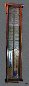 Flagstaff Hill Maritime Museum and Village
Barometer, 1858-1869
The barometer was either made or sold by T. Gaunt & Co. of Melbourne, a manufacturer, importer and retailer of a wide variety of goods including jewellery, clocks and watches, navigational and measuring instruments, dinnerware, glassware and ornaments. Thomas Gaunt photograph was included in an album of security identity portraits of members of the Victorian Court, Centennial International Exhibition, Melbourne, 1888. (See below for further details.) Admiral Fitzroy Pattern Barometer History: The stick mercury barometer was named after Admiral Robert Fitzroy of the Royal Navy (1805-1865) for his detailed instructions on how to interpret the weather, which were included with the instrument. Fitzroy was the captain of the HMS Beagle, also a weather forecaster to Charles Darwin and the second Governor of New Zealand. He developed many different types of barometers and was the first person to introduce the science of weather forecasting to the British Isles. A local manufacturer of scientific instruments, Thomas Gaunt, produced the barometer that was adapted for the southern hemisphere by Robert Ellery, the State Astronomer based at the Melbourne Observatory. In the original sale catalogue for Gaunt's, the item is described as "Gaunt's Fitzroy Barometers" and it was priced from 25/- to ₤9.9s. History of Thomas Gaunt: Thomas Gaunt established Melbourne's leading watchmaking, optical and jewellery business during the second half of the 19th century. Gaunt arrived in Melbourne in 1852, and by 1858 had established his own business at 14 Little Bourke Street. Around 1869 he moved to new premises in Bourke Street on the corner of Royal Arcade. Gaunt's shop quickly became a Melbourne institution. Gaunt proudly advertised that he was 'The only watch manufacturer in the Australian colonies'. While many watches and clocks may have had Gaunt's name on the dial, few would have been made locally. Gaunt did make some watches for exhibitions, and perhaps a few expensive watches for wealthy individuals. Gaunt's received a telegraph signal from Melbourne Observatory each day to correct his main clock and used this signal to rate and repair ship's chronometers and good quality watches. His main horological manufacturing was directed at turret clocks for town halls, churches and post offices. These tended to be specific commissions requiring individualised design and construction. He made the clock for the Melbourne Post Office lobby, to a design by Government Astronomer Robert Ellery, and won an award at the 1880-81 Melbourne International Exhibition for his turret clock for the Emerald Hill Town Hall. He became well known for his installation of a chronograph at Flemington Racecourse in 1876, which showed the time for the race, accurate to a quarter of a second. The firm also installed the clockwork and figures for Gog and Magog in the Royal Arcade. Thomas Gaunt also developed a department that focused on scientific instrumentation, making thermometers and barometers (from imported glass tubes), telescopes, surveying instruments and microscopes. Another department specialised in electroplating for trophies, awards and silverware, and the firm manufactured large amounts of ecclesiastical gold ware and silverware, for the church including St Patrick's Cathedral. There are no records that disclose the number of employees in the firm, but it was large enough for Gaunt to hold an annual picnic for the watchmakers and apprentices at Mordialloc from 1876; two years previously they had successfully lobbied Gaunt to win the eight hour day. Gaunt's workforce was reportedly very stable, with many workers remaining in the business for 15 to 30 years. Gaunt's wife Jane died on September 1894, aged 64. They had one son and six daughters, but only three daughters survived to adulthood. Two became nuns at the Abbotsford Convent and one daughter, Cecelia Mary Gaunt (died 28 July 1941), married William Stanislaus Spillane on 22 September 1886 and had a large family. Gaunt died at his home in Coburg, Victoria, leaving an estate valued at ₤41,453. The business continued as T. Gaunt & Co. after his death. The barometer is historically significant as an example of the work of Melbourne’s leading scientific instrument maker, Thomas Gaunt. The barometer has social significance as an example of the type of scientific equipment that Thomas Gaunt expanded his horology business into producing. Further social significance lies in the fact that Robert Ellery, the Government Astronomer who designed the local version of the barometer, had a direct connection with the Melbourne Athenaeum founded in 1839 as the Melbourne Mechanics' Institution. Its purpose was "the diffusion of literary, scientific and other useful information". There are also records of a T Gaunt as a subscription and committee member of this the Athenaeum organisation during the 1870s and 1880s which may be Thomas Gaunt, unfortunately still unverified.Stick mercury barometer known as the Admiral Fitzroy Barometer. It comprises an oblong wooden case with glass front panel, ornate pediment, barometer with bulb cistern (empty of fluid), cleaning brush with printed instructions for interpreting information given by the gauge affixed to left and right face of instrument. Includes a thermometer. The barometer appears to be intact. Adapted to the Southern Hemisphere. Special remarks by Admiral Fitzroy. Made by Thomas Gaunt, Melbourne. Manufacturer's details are on back of wooden casing. Rear has upper and lower brass screw plates for securing to vertical surface."Manufactured by Thomas Gaunt, 14 Little Bourke Street, Melbourne. "flagstaff hill, warrnambool, shipwrecked-coast, flagstaff-hill, flagstaff-hill-maritime-museum, maritime-museum, shipwreck-coast, flagstaff-hill-maritime-village, barometer, admiral fitzroy, thomas gaunt, thomas gaunt of melbourne, clockmaker, admiral fitzroy barometer, barometer instructions, gaunt’s fitzroy barometer, gaunt’s of melbourne, gog and magog designer, horological manufacturer, meteorological instrument, melbourne athenaeum, melbourne mechanics' institution, melbourne observatory time signal, robert ellery government astronomer, scientific instrument, stick mercury barometer, thermometer, weather forecast, t gaunt & co -
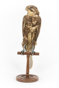 The Beechworth Burke Museum
Animal specimen - Brown Falcon, Trustees of the Australian Museum, 1860-1880
The Brown Falcon is a small to medium bird of prey which can be found all throughout Australia. These birds are raptors and typically feed on mammals, birds, snakes, insects and rabbits. The Brown Falcon are located in all but the densest forests. They typically prefer to reside in locations of open grassland and agricultural areas which have scattered trees or telephone poles which the bird can perch on. When frequenting towns located in the Australian Outback, these birds are reportedly quite tame and can be approached by humans. They may stay in the same location throughout the year or chose to move around locally in response to any changes in weather conditions. This specimen is part of a collection of almost 200 animal specimens that were originally acquired as skins from various institutions across Australia, including the Australian Museum in Sydney and the National Museum of Victoria (known as Museums Victoria since 1983), as well as individuals such as amateur anthropologist Reynell Eveleigh Johns between 1860-1880. These skins were then mounted by members of the Burke Museum Committee and put-on display in the formal space of the Museum’s original exhibition hall where they continue to be on display. This display of taxidermy mounts initially served to instruct visitors to the Burke Museum of the natural world around them, today it serves as an insight into the collecting habits of the 19th centuryThis specimen is part of a significant and rare taxidermy mount collection in the Burke Museum. This collection is scientifically and culturally important for reminding us of how science continues to shape our understanding of the modern world. They demonstrate a capacity to hold evidence of how Australia’s fauna history existed in the past and are potentially important for future environmental research. This collection continues to be on display in the Museum and has become a key part to interpreting the collecting habits of the 19th century.The Brown Falcon specimen has plumage which is mostly brown and intermixed with white. This provides the appearance of having spotted colouring on the birds back. The head is also mostly brown with white under the beak area and a characteristic brown streak under the eye area. The eye is made from dark coloured glass.3 / Brown Hawk / See Catalogue, page 2 / taxidermy mount, taxidermy, animalia, burke museum, beechworth, australian museum, skin, reynell eveleigh johns, bird, brown falcon, falconidae -
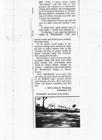 Halls Gap & Grampians Historical Society
Newspaper - B/W
She was a guest house called "Myrtlebank" and she was a very gracious old residence in a near perfect setting, surrounded by the towering peaks of the Grampian Mountains in Victoria. She was visited by thousands in her time, many of whom returned year after year to enjoy her hospitality. I first visited her 40 years ago and she won my heart from the moment I saw her. In those days, guest houses were in their prime - motels were unheard of. To this day, I can recall the delicious meals at "Myrtlebank" with pure country cream and home grown produce featuring largely. All the guests would gather in the enormous sitting rooms warmed by huge log fires in colder weather and , in the evenings, all sorts of games would be played, charades being first favourite with young and old alike. Several days a week a bus would pick up guests, along with those from other guest houses, and surrounding areas would be visited. Mostly, though, we walked - sometimes right across behind the Wonderland Range to Mount Victory. Now, "Myrtlebank" is no more. The site where she once stood is at the bottom of the Bellfield Lake, covered forever with fathoms of water. But I and many others will always remember and love her. Letter to paper with photograph of MyrtlebankSubmitted by Mrs O. Woolcock, Tottenham Vic who won $15 prize describing accomodation for guests at Myrtlebankaccommodation, guesthouses, myrtlebank -
 Flagstaff Hill Maritime Museum and Village
Functional object - Valve, or before 1889
This Non-return valve was recovered from the wreck of the Newfield. Non-return valves can be used to pump water out.of a vessel The barque Newfield left Liverpool on 1st June 1892 with a cargo of 1850 tons of fine rock salt for Brisbane. About six weeks later the ship ran into very heavy weather approaching the Australian coast. On 28th August at about 9pm her master, Captain George Scott, observed between the heavy squalls the Cape Otway light on the mainland of Victoria, but due apparently to a navigational error (the chronometers were incorrect), he mistook it for Cape Wickham on King Island, some 40 miles south. He altered course to the north expecting to run through the western entrance of Bass Strait, but instead, at about 1:30am, the ship ran aground about about 100 yards from shore, one mile east of Curdies River. The vessel struck heavily three times before grounding on an inner shoal with six feet of water in the holds. The Newfield remained upright on the reef with sails set for a considerable time as the wind slowly ripped the canvas to shreds and the sea battered the hull to pieces. Seventeen men survived the shipwreck but the captain and eight of his crew perished.Flagstaff Hill’s collection of artefacts from the Newfield is significant for its association with the shipwreck Newfield, which is listed on the Victorian Heritage Registry. The collection is significant because of the relationship between the objects. The Newfield collection is archaeologically significant as the remains of an international cargo ship. The Newfield collection is historically significant for representing aspects of Victoria’s shipping history and its association with the shipwreck.A non-return valve used to connect to a hose on a bilge pump on a vessel. This valve is from the ship Newfield and was used to pump water out of the vessel. warrnambool, shipwrecked coast, flagstaff hill, flagstaff hill maritime museum, maritime museum, shipwreck coast, flagstaff hill maritime village, shipwrecked artefact, 1892, 1893, 28 august 1892, 29 august 1892, barque, curdies river, newfield, nineteenth century, non return valve, peter ronald, peterborough, port campbell, shipwrecks, victorian shipwrecks, valve, bilge pump -
 Federation University Historical Collection
Photograph - Black and White, Former Ballarat Library, c1960
First known development on this site was the establishment of the Government Camp from the early 1850s. It was established to accommodate officials, troopers and police who were needed to administer the goldfields. Some permanent buildings were constructed. Lack of materials and bad weather prolonged the building of more permanent buildings and most men were still living in tents. Area was known as Camp Reserve. In 1864 a subdivision map shows the reserve be used for Public Buildings. Library applied for land on corner of Sturt and Camp Streets in 1878. 1880s plans show section of the reserve be used for a Free Library and Reading Room. Lease was granted and the old mining boardroom was initially used. Land for additional building to house a Museum and Art Gallery sought and agreement reached in 1882-3. Compensation paid to owners and library granted the land. Plans for a new library building with tower and lantern roof abandoned due to lack of funds. It wasn't until 1895 that a solution to funding was found and the library was able to begin constructing the complex of buildings on the Free Library Reserve. A number of changes have occurred since 1910s - the Classical Revival facade replaced with an angled facade in a stripped Classical style with Art Deco features and high parapet. Building is now part of Federation UniversityPhotograph of former library. Shows a two-storey rendered brick building in a Classical style. Some Art Deco features. Central pair of double windows with single window either side. High parapet above.government camp, goldfields, camp reserve, free library, reading room, sturt street, camp street, museum, art gallery, troopers, police, barracks, camp street -
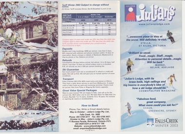 Falls Creek Historical Society
Flyer - Julian's Lodge 2003
Julian Newton-Brown arrived at Falls Creek in 1957. He had studied Pharmacy at Melbourne University. After developing a love for the mountains, Julian moved to Mt. Beauty and then Falls Creek. He worked for the SEC in the test laboratory at Rocky Valley reading weather instruments. By working several jobs, Julian was able to build a small lodge of 10 beds named “Arundel”, located at 18 Slalom Street, Falls Creek. The lodge is now the “Elk at Falls”. Arundel prospered and Julian extended it to include 32 beds and changed its name to "Julian’s” in 1961. When alcohol restrictions were eased in Falls Creek, Julian built a night club which he called “Big Julian’s” and later “THE MAN”. When Julian and his wife Beth retired and left Falls Creek, their son took over running the lodge. An active community man, Julian was a member of the Falls Creek Chamber of Commerce, a member of the SES, a stakeholder in Falls Creek, an author and a documentary maker. Julian Newton-Brown died in May 2020. In 2003 when this flyer was published operation of Julian's Lodge transferred from Julian and is wife Beth to their son Charlie Brown, a former Australian Champion and World Cup skier and his wife, Bena.This item is significant because it gives details of an important lodge at Falls Creek, Victoria.A colour flyer which gives a large amount of information about facilities and tariffs for Julian's Lodge Falls Creek for the 2003 season. The flyer folds to one-third of its open size.julian's lodge, julian newton brown, falls creek ski lodges, accommodation falls creek, charlie brown -
 Parks Victoria - Wilsons Promontory Lightstation
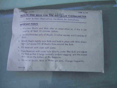
Muslin & Wick
This item, which dates to 1988, is contained in the original supply packet and survives in good condition. It was commonly used by lightkeepers for both wet and dry bulb thermometers, with the muslin going into the bottom of the dry bulb where it was held in place by the wick and ‘end of the wick was then placed in a jar of deep water to keep the bulb cool’. The difference in temperatures between the dry and wet bulb thermometers could then be worked out to establish the dew point in the air.They were common in lightstations, but this intact item remains in the original packaging and is a fine representative example of its kind. It was acquired from the Bureau of Meteorology. Recording and communicating weather readings was an important facet of lightstation work and a number of different but related items of meteorological equipment survive at the six lightstations managed by parks Victoria. The Cape Nelson collection includes a pair of Australian-made thermometers in their original box, both in Fahrenheit, with one recording the minimum, the other the maximum temperature and a barometer table with instructions for correcting readings. Cape Otway has a Beaufort Scale, a table of wind forces which lists 12 types on a scale of 1 to 12, and provides associated speed in knots and travel time per minute or hour. Gabo Island has an anemometer, wind speed indicator and a wind speed recorder.Muslin and wick for a wet bulb thermomenter in unopened white paper packaging with directions for use printed on the package on the front.On front of package,"MUSLIN AND WICK FOR WET BULB THERMOMETER......." -
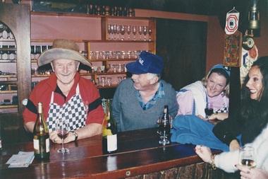
 Falls Creek Historical Society
Photograph - Paul Hogan at Julian's Lodge 1973
Julian Newton-Brown arrived at Falls Creek in 1957. He had studied Pharmacy at Melbourne University. After developing a love for the mountains, Julian moved to Mt. Beauty and then Falls Creek. He worked for the SEC in the test laboratory at Rocky Valley reading weather instruments. By working several jobs, Julian was able to build a small lodge of 10 beds named “Arundel”, located at 18 Slalom Street, Falls Creek. The lodge is now the “Elk at Falls”. Arundel prospered and Julian extended it to include 32 beds and changed its name to "Julian’s” in 1961. When alcohol restrictions were eased in Falls Creek, Julian built a night club which he called “Big Julian’s” and later “THE MAN”. When Julian and his wife Beth retired and left Falls Creek, their son took over running the lodge. An active community man, Julian was a member of the Falls Creek Chamber of Commerce, a member of the SES, a stakeholder in Falls Creek, an author and a documentary maker. Julian Newton-Brown died in May 2020. In 2003 when this flyer was published operation of Julian's Lodge transferred from Julian and is wife Beth to their son Charlie Brown, a former Australian Champion and World Cup skier and his wife, Bena.This item is significant because it gives details of an important lodge at Falls Creek, Victoria.A black and white image of Paul Hogan, John Cornell and other people sitting near fire place in the dining room at Julian's Lodge in 1973. Paul Hogan and a group of actors and film crew spent several days in Falls Creek filming a Winfield cigarette commercial, in which they were portrayed as ski instructors. According to Julian Brown's book "Falls Creek - How it came to be", they brought in a truck load of polystyrene balls to create snow. The commercial was in 16mm for television and 36 mm for cinemas. It took them three days to shoot a six second scene in the dining room at Julian's lodge.julian's lodge, julian newton brown, falls creek ski lodges, accommodation falls creek, charlie brown -
 Falls Creek Historical Society
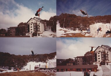
Photograph - Man made ski jump at Falls Creek 1961
Julian Newton-Brown arrived at Falls Creek in 1957. He had studied Pharmacy at Melbourne University. After developing a love for the mountains, Julian moved to Mt. Beauty and then Falls Creek. He worked for the SEC in the test laboratory at Rocky Valley reading weather instruments. By working several jobs, Julian was able to build a small lodge of 10 beds named “Arundel”, located at 18 Slalom Street, Falls Creek. The lodge is now the “Elk at Falls”. Arundel prospered and Julian extended it to include 32 beds and changed its name to "Julian’s” in 1961. When alcohol restrictions were eased in Falls Creek, Julian built a night club which he called “Big Julian’s” and later “THE MAN”. When Julian and his wife Beth retired and left Falls Creek, their son took over running the lodge. An active community man, Julian was a member of the Falls Creek Chamber of Commerce, a member of the SES, a stakeholder in Falls Creek, an author and a documentary maker. Julian Newton-Brown died in May 2020. The ski jump was built by Julian Newton Brown and Nick Popov near Diana Lodge. Nick Popove and his wife Jean can be seen on the far right in the black and white image.This item is significant because it gives details of an important lodge at Falls Creek, Victoria.Photographs of action at the ski jump constructed c1960. julian's lodge, julian newton brown, falls creek ski lodges, accommodation falls creek, charlie brown -
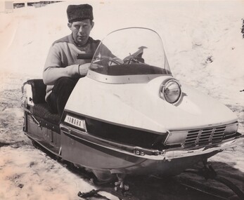 Falls Creek Historical Society
Photograph - Julian Newton Brown on Yamaha SL 351
Julian Newton-Brown arrived at Falls Creek in 1957. He had studied Pharmacy at Melbourne University. After developing a love for the mountains, Julian moved to Mt. Beauty and then Falls Creek. He worked for the SEC in the test laboratory at Rocky Valley reading weather instruments. By working several jobs, Julian was able to build a small lodge of 10 beds named “Arundel”, located at 18 Slalom Street, Falls Creek. The lodge is now the “Elk at Falls”. Arundel prospered and Julian extended it to include 32 beds and changed its name to "Julian’s” in 1961. When alcohol restrictions were eased in Falls Creek, Julian built a night club which he called “Big Julian’s” and later “THE MAN”. When Julian and his wife Beth retired and left Falls Creek, their son took over running the lodge. An active community man, Julian was a member of the Falls Creek Chamber of Commerce, a member of the SES, a stakeholder in Falls Creek, an author and a documentary maker. Julian Newton-Brown died in May 2020. In 2003 when this flyer was published operation of Julian's Lodge transferred from Julian and his wife Beth to their son Charlie Brown, a former Australian Champion and World Cup skier and his wife, Bena.This item is significant because it gives details of an important lodge at Falls Creek, Victoria.A black and white image of Julian Newton Brown testing a Yamaha SL 351 in 1968.julian's lodge, julian newton brown, falls creek ski lodges, accommodation falls creek, charlie brown -
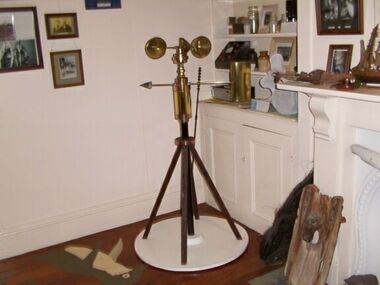 Parks Victoria - Gabo Island Lightstation
Anemometer
This device was used to measure surface wind speed and direction. This anemometer was located on a concrete pad outside room 2.15 on a steel pole. The pole was considered unsafe and the anemometer was relocated to it's current position. When lowering the pole it fell over and was badly damaged. The Bureau of Meteorology donated it to the museum. It was then repaired and restored. The central pole on which it is mounted is galvanised iron pipe painted black. The anemometer, a portable device that manually measures wind speed, was a necessary instrument once common to all weather stations. The arms are attached to a vertical rod and as the wind blows, the cups rotate, making the rod spin. The stronger the wind blows, the faster the rod spins. The anemometer counts the number of rotations, or turns, which is used to calculate wind speed, surface wind and direction. They were designed to be durable to withstand the corrosive environment and strong winds expected at coastal sites such as those at Gabo Island. Anemometers existed in the nineteenth century and their design was improved by various experts including John Robinson in 1846, John Patterson in 1926, Brevoort and Joiner in 1935 and Derek Watson in 1991 who added wind direction measurement to its functions. This example was made for the Bureau of Meteorology by the Melbourne instrument company, Synchrotac, which became registered and incorporated on 26 July 1966. It is now displayed inside the building. A good example of its kind, the anemometer has first level contributory significance for its historic value and provenance to the lightstation.Anemometer and tripod stand. Three cupped brass discs on rotating arms fixed to turned brass cylinder shaped shaft. Beneath discs is a lead directional wind arrow attached to a rotating arm. A wooden three legged stand with central supporting pole of black painted hardwood and attached to a white painted marine ply circular base.Under wind cups: " SYNCHROTAC / MELB. / ser.no.70/372 / MADE IN AUSTRALIA." Above wind direction arrow: "C.OF.APT..../ SYNCHROTAC / MELB ? MADE IN AUSTRALIA / ser.no.70/372" -
 Melbourne Legacy
Photograph, Back to Caulfield 1996, 1996
For many years Legacy had a "Back to Caulfield Race Day" for Legatees, widows and their families. In 1995 a Legacy 'Lone Pine' was planted. The article in the Answer says: “We were delighted with the many Legacy Widows, Legatees and friends of Legacy who participated in the Commemorative Race Day at Caulfield Sunday 25th August - marking the 75th anniversary of the RAAF. The VATC had a range of displays and activities including a breathtaking parachute demonstration by the Blue Eagles. It was touch and go for a while due to the weather conditions but once the Blue Eagles jumped they all reached their designated target in front of the winning post. Legacy even had a special race named after it: “The Legacy Widows Appeal Handicap”. Our thanks to the VATC for this courtesy. Hope we had a few winners! Vice President, Legatee Brian ‘Lucky’ Luscombe placed a wreath at the legacy ‘Lone Pine’ - a descendant of the Gallipoli ‘Lone Pine’ on behalf of the Legacy Family. The historic tree was presented to Caulfield last year as part of the events to mark the 1995 Australia Remembers year.” The photos show children playing mini golf as well as the Historical Re-enactment Society of Australia with old military equipment and wearing old military uniforms. The racecourse also had a vintage plane on display with military vehicles.Legacy retains a tie with Caulfield racecourse as it was once an army camp and staging post of young men going overseas to war and now it is the site of a lone pine. The annual gathering at Caulfield racecourse was an event that gets the Legacy family together.Colour photo x 18 of an event at Caulfield racecourse in 1996 and an article in The Answer.Printed on back events, wreath laying ceremony, answer -
 Warrnambool and District Historical Society Inc.
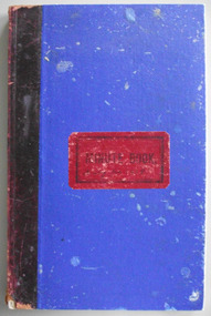
Journal - Diary, Diary of Augustus Bostock 1918-1920, Circa 1918
Augustus Bostock was the 9th child of Robert & Rachael Bostock of Vaucluse Epping Forest, Van Diemen’s Land. He was only 4 years old when his mother died. He was inspired by his father to seek his fortune in the Western District of Victoria. He arrived around 1850. He married Margaret Aitkin in July 1865. Augustus owned several properties in the district and leased others. He sat on the court of Warrnambool, Mortlake or Hexham as required. He resided at Marramook in Hawkesdale and later moved to Vaucluse in Hopetoun Road Warrnambool, where he died in 1920 at the age of 87. He was involved in many aspects of life in the Western District, racing, cricket, and social activities to name a few. This diary shows the daily entries over a long period of time with activities ranging from fencing, visiting neighbours and weather details. It mentions many local people and many properties he visited. The last entry in the diary is for Wednesday June 2nd 1920 and states, “I have been a bit out of sorts, very short in the breath. Dr Connell called returning from Orford. Gus came down and brought our mail. W fair some rain” Augustus died seven weeks later, August 20th 1920.Augustus Bostock along with a number of his brothers was one of the earliest pioneers in the Western District of Victoria. This diary sheds considerable light onto the life of Augustus and people of his era. There is a wealth of information on a range of topics relating to early life in Warrnambool and district.Bright blue cloth over card cover with maroon leather binding on spine. Red label attached to front cover Pages are all handwritten.188 pages. Vaucluse W’Bool A Bostock 1918 handwritten on front page. Diary for 1918 handwritten on front label which has minute book printed on it.warrnambool, augustus bostock, bostock diary -
 Bendigo Historical Society Inc.
Newspaper - LONG GULLY HISTORY GROUP COLLECTION: BENDIGO'S CENTURY VOLUME FOUR: 1930 - 1939
Newspaper supplement titled Bendigo's Century Volume Four: 1930 - 1939. Front page is titled Bendigo's Century and has a photo of some women at the Bendigo Jockey Club, 1930s. Each year has heading of Who's Who, Weather, Sport and Business. First years are 1930 - 1939 titled A look back when. The page has photos of the Eaglehawk Cricket Club's first A Grade cricket premier ship team (1932 - 1933)., The monument to the late Bendigo mining magnate Ernst Mueller in Rosalind Park, The Bendigo Stock Exchange in the early 1930's - pictured are L L Dungey, T Williams, M P Kelly, C Mueller, E Hommoloff, R Kelly, T H Busst, T Hall, R Trembath, E A Woolcock, and C Burridge, the Carshalton mine in 1936 and The Edith and G V Lansell Laboratory at the Bendigo Hospital. 1930 - a photo of St Andrew's Church, the sundial outside the RSL Memorial Hall, The late Monsignor Rooney and The late John Douse Langley. The Ironbark Mine was the top gold producer. 1931 - Radio station goes on air, 1932 - Sir John dies, 1933 Bodyline men come to town, 1934 - Heroic rescues, 1935 - Hospital's new wing opened, 1936 - King mourned, 1937 - Beehive store towers above, 1938 - Mining shows mixed results and 1939 - Outbreak of war sobering.bendigo, history, long gully history group, the long gully history group - bendigo's century - volume four: 1930 - 1939, eaglehawk cricket club, ernst mueller, the bendigo stock exchangel l dungey, t williams, m p kelly, c mueller e hommoloff, r kelly, t h busst, t hall, r tremabath, e a woodcock, c burridge, charshalton mine, edith and g v lansell laboratory, st andrew's church, rsl memorial hall, mr gordon carter, sir john monash, state electricity commission, cr r watson, colonel gt v lansell, empire press congress, bendigo advertiser, mr e j hogan, eppalock weir, lyric theatre, bendigo red cross, mrs george mackay, st andrew's presbyterian church, mrs william hunter, right rev john douse langley, monsignor rooney, bendigo art gallery, the ironbark mine, coliban water, mr w wright, station 3bo, amalgamated wireless of australia ltd, advance bendigo group, the north league, st aidan's orphanage, bendigo freezing works, mr w wright, bendigo advertiser, mr w j stephens, advance bendigo group, north league, garden gully united gold mining company, bendigo football league, sir john quick, john quick snr, ironbark foundry, bendigo evening news, bendigo independent, bendigo advertiser, deakin governmnet, sir charles kingsford smith, southern cross, eppalock weir, bendigo art gallery, the hercules mine, gillies, aids & appliance shop, anne caudle centre, bill woodfull, harold larwood, dr john mccarthy, the hercules, douglas jardine, don bradman, sacred heart cathedral, joseph stapleton, john lynch, bert mcconchie, new red white and blue mine, royal humane society, william james, vernon shaw, south new moon mine, bendigo hospital, bendigo base hospital, duke of gloucester, rsl memorial hall, electricity commission, eaglehawk borough council, the plaza, backhaus estate, amalgamated freezing company, fortuna villa, mrs edith lansell, colonel lansell, the hercules mine, toni riley pharmacy, boardwalk, barkly hyett, the big blue consolidated company, the bendigo hospital, eaglehawk football team, kurmala wing of the bendigo base hospital, sir isaac isaacs, lyric theatre, sir john quick, hanro knitting mills, st luke's toddlers home, st aidan's orphanage, rsl memorial hall, lord and lady huntingfield, cr michelsen, bendigo art gallery, bendigo agricultural show, new blue mine, joseph stapleton, bendigo law association, bendigo hospital committee of management, bendigo rotary club, mr j mcrae, education department, andrew sunstan, sir stanley argyle, bendigo football league, north blue mining company, cr staples, king george v, king edward viii, cr j a michelsen, andrew mclay, bendigo advertiser, cohn bros, mrs wallis simpson, king george vi, capping mine shafts 1936, bendigo art gallery, madge freemen, william john leslie cross, judge wasley, the myer emporium, the baptist church, salvation army, ron masters, the central nell gwyn, sir john quick, leanne mcdonnell, windermere hotel, rev donald baker, john rumbold, central nell gwynne, the beehive building, the beehive store, james buick and co, thomas hope henderson, buick henderson & co, mr goodison, mr r o henderson, lt-col henderson, angus mackay, bendigo sewerage authority, mr s gordon moore, commercial bank of sydney, bendigo advertiser, edward alan morcom, polio, dr gardner kerr, the right rev conald baker, ridley theological college -
 Bendigo Historical Society Inc.
Container - CHOCOLATE BOX COLLECTION: PASCALL BOX, 1920s
Object.Pascall 1920s Yellow Chocolate Box. Design Flanged Sexangular Box with Curved Sectional Top, Sepia Photograph with Subject's Hat and Dress tinted in Pale Yellow in Centre of Lid. Photograph Surrounded by Gold Border. Subject Young Woman & Her Pet Cat. Photograph has White Mark PC Parts in a circle and the number 524 underneath. Inside Lid Pascall 1 lb Net. Contained in Box Labels Packers No 493 and Checkers No 476. Packaging Brown Paper and Fine Paper Shavings in Pale & Dark Colours. Also Another Tag Buff Paper & Red Text In Top Left Hand Corner is the Pascall London Trademark Purity & Sweetness Seal & In The Top Right-hand Corner is A Floral Emblem & The Words Furzedown. The Title On This Tag Reads Co-operation Between The Manufacturer & Consumer. The Remaining Text Reads: - These chocolates were packed with the greatest care and left in our factory in perfect condition. Extremely hot weather or contact with steam pipes may turn these chocolates grey. This is not an indication of age but of the temperature to which they have been exposed. Goods are all packed full weight; the paper shavings used are for packing and protection only. If any complaint necessary please return this ticket with the goods. James Pascall, Ltd London England. Chocolates are also still contained within the box all these years later.domestic equipment, containers, decorative chocolate box -
 Bendigo Historical Society Inc.
Document - VIKKI SPICER COLLECTION: BENDIGO OPERATIC SOCIETY PROGRAMME BOOKLET, June 14th, 1963
Bendigo Operatic Society Programme Booklet Production 'Carousel' performed at the Capital Theatre View Street Bendigo for a season of six nights. Opening June 14th, 1963. 'Carousel' presented with the permission of Chappell & Co. Ltd. A Beatrice Oakley Production. Music Richard Rodgers, Book & Lyrics Oscar Hammerstein II. Some Key Songs: 'If I Loved You', 'June is Busting Out All Over,' 'You'll Never Walk Alone.' Carousel is the second musical by the team of Richard Rodgers (music) and Oscar Hammerstein II (book and lyrics). The 1945 work was adapted from Ferenc Molnár's 1909 play Liliom, transplanting its Budapest setting to the Maine coastline. The story revolves around carousel barker Billy Bigelow, whose romance with millworker Julie Jordan comes at the price of both their jobs. He attempts a robbery to provide for Julie and their unborn child; after it goes wrong, he is given a chance to make things right. A secondary plot line deals with millworker Carrie Pipperidge and her romance with ambitious fisherman Enoch Snow. Cast: Patricia McCracken, Mary Ellis, Joan Heard, IaIan Young, Peter Houston, Reginald Boromeo, Heather Lindhe, Fred Trewarne, Roger Sprawson, Alan Weatherly, Graham Filcock, Victor White, David Lea, Robert Urquhart, Annette Wilson, Robert Wenn.Arthur Hocking Press.clubs and associations, theatre, bendigo operatic society, https://bendigotheatrecompany.org/about/ -
 Falls Creek Historical Society
Photograph - Bogong Trip 1951- Outside Cleve Cole Hut
MEYER COLLECTION - FALLS CREEK PHOTOS In 1947 a determined group of like-minded State Electricity Commission (SEC) staff including Ray Meyer, the chief surveyor of the Kiewa Hydro-Electric Scheme, had a common interest that revolved around the skiing potential of the snow-covered high plains which included what is now the resort of Falls Creek. The six SEC employees, Toni St Elmo, Ray Meyer, Jack Minogue, Lloyd Dunn, Adrian Ruffenacht and Dave Gibson (together with their families) banded together to secretly build a 'hut' that was the first ski lodge at Falls Creek. Using a road built in 1930s to gain access to Falls Creek, their hut project was carried out in secret as efforts by other skiers were blocked by H.H.C. Williams – the engineer in charge of the Hydro Scheme. In 1946 Ray Meyer made a trip to the Lands Office in Melbourne. He came away with a 99-year lease on three acres that was ideally suited for a hut designed by Lloyd Dunn. Adrian Ruffenacht (Design Engineer for the KHS) had suggested where the group should build because of easy access to a spring for water. Much of the building material required was scavenged from derelict huts on the high plains. Due to the need for secrecy, the determined group worked on the hut in the evenings and weekends to avoid detection. During the building period the group had met at Echidna Rock (now known as Eagle Rock) where Skippy St Elmo announced, "This is my favourite ‘Skyline’.” And so the first lodge in the area at Falls Creek Ski Resort came into existence. With the development of the International Poma in the 1970s, the Skyline Lodge, which was sited between the ski-lift’s pole one and pole two, was demolished. However, the legacy of Ray Meyer, Toni St Elmo, Jack Minogue, Lloyd Dunn, Adrian Ruffenacht and Dave Gibson and Skyline lives on in the vibrant atmosphere of Falls Creek Resort. The MEYER COLLECTION documents developments on the Kiewa Hydro Scheme and their life at Falls Creek from the mid 1930s to 1960s.This image is significant because it depicts aspects of the life of a pioneering family of Falls Creek and the founders of "Skyline", the first lodge at Falls Creek.Black and White Images taken at Cleve Cole Hut Photo 1 Outside Cleve Cole 1951 - From Left: Ray Meyer, Wal Johnson and other people from a visiting group Photo 2 Cleve Cole Hut Mt. Bogong CLEVE COLE HUT was built in 1937 for the Ski Club of Victoria, to commemorate pioneer skier, Cleve Cole, who died on a disastrous ski trip across the high In August 1936 three men, Cleve Cole, Mick Hull, and Howard Michell, skied from Mount Hotham across the Bogong High Plains to Mount. On reaching the mountain they became trapped for four days on the summit ridge by appalling weather conditions. For three days they followed the Big River through rough country before deciding that Howard should continue alone to find help, leaving Mick to care for Cleve who was barely able to continue. Three days later a search party, raised after Howard had reached Glen Valley, found Cleve and Mick. Within two days the group arrived at Glen Valley where, tragically, Cleve Cole died later that night. In memory of Cleve’s life and his pioneering work in the Victorian alpine country it was decided to build a refuge hut on the mountain. It is called the Cleve Cole Memorial Hut.falls creek, bogong high plains, ray meyer, cleve cole hut -
 Marysville & District Historical Society
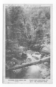
Postcard (item) - Black and white postcard, Rose Stereograph Company, Talbot Drive, Marysville, Vic. No. 3, The Taggerty River, 1913-1967
A postcard in a series produced by the Rose Stereograph Company in Victoria, Australia as a souvenir of Marysville.A black and white photograph taken along Lady Talbot Drive, Marysville, in Victoria, of the Taggerty River. Lady Talbot Drive is a 24 kilometer scenic rainforest car journey which passes a number of walks and waterfalls in the Yarra Ranges National Park. Lady Talbot Drive is named after Lady Sarah Elizabeth, the wife of Sir Reginald Talbot, who was the Governor of Victoria from 25th April, 1904 to 6th July 1908. This postcard was produced by the Rose Stereograph Company as a souvenir of Marysville.Walked here this morning/ Lure making this afternoon POST CARD. Correspondence Address Kooringa 20th March '46 Dear Margaret,/ Please excuse pencil/ but don't think my pen will see/ the distance./ Expect you have heard from Rog./ that we are having a pretty good/ time, the weather wasn't so hot but/ has picked up now and it is/ glorious./ I've had a couple of nice trips/ with Rog and friends, they took/ me to Eildon Weir one day and took/ Ness and I mushrooming yesterday not/ that we got many mushrooms but/ it was a beautiful drive./ I hope you have a very happy/ birthday tomorrow./ How is the old leg going?/ Nancy work again on Monday,/ I will slip out and see you when/ I get back./ Hoping your leg is improving and/ that you have a happy day tomorrow/ Yours sincerely/ Florencetalbot drive, marysville, victoria, taggerty river, postcard, souvenir, sir reginald talbot, lady sarah elizabeth talbot, southern cross series postcard, 2308 -
 Eltham District Historical Society Inc
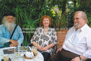
Photograph, Fay Bridge, Book launch of Laughing Waters Road by Jane Woollard at Montsalvat, Eltham, 30 January 2016
Laughing Waters Road , the book was launched at Montsalvat in Eltham. On Saturday, January 30, 2016, Nillumbik Council launched this book. The weather was cool; just as well, considering over 500 people attended this very pleasant event where food and drink were plentiful. The Australian Government and Nillumbik Shire Council funded the book and it was designed by Wayne Rankin of North Warrandyte. The dedication page is to our very own Ranger Campbell Beardsell OAM of Parks Vic who taught Jane to be “passionate about the environment of this special place” (p260). FOWSP members Val Polley, Linda Rogan and Ken Crook contributed to the content and photos. David Wandin, Wurundjeri Elder, gave a Welcome to Country and officially launched the book after the Mayor of Nillumbik, Cr Hattam, made introductions. Jane Woollard followed with a brief outline of how she came to write the book (her very first) and read out loud the last paragraph which focuses on reconciliation and shared culture. Jane declared in her preface that the book “has been formed by attending to the connection between rivulets of memories, creeks of hearsay, rivers of tales, the meanders of local legend and the deep, still pools of the archive.” Very poetic! - Lynda Gilbert Newsletter; Friends of Warrandyte State Park March 2016, Volume 34 Number 2 Laughing Waters Road , the book was launched at Montsalvat in Eltham ON SATURDAY 30 JANUARY Nillumbik Council launched this book. The weather was cool; just as well, considering over 500 people attended this very pleasant event where food and drink were plentiful. The Australian Government and Nillumbik Shire Council funded the book and it was designed by Wayne Rankin of North Warrandyte. The dedication page is to our very own Ranger Campbell Beardsell OAM of Parks Vic who taught Jane to be “passionate about the environment of this special place” (p260). FOWSP members Val Polley, Linda Rogan and Ken Crook contributed to the content and photos. David Wandin, Wurundjeri Elder, gave a Welcome to Country and officially launched the book after the Mayor of Nillumbik, Cr Hattam, made introductions. Jane Woollard followed with a brief outline of how she came to write the book (her very first) and read out loud the last paragraph which focuses on reconciliation and shared culture. Jane declared in her preface that the book “has been formed by attending to the connection between rivulets of memories, creeks of hearsay, rivers of tales, the meanders of local legend and the deep, still pools of the archive.” Very poetic! - Lynda Gilbert Newsletter; Friends of Warrandyte State Park March 2016, Volume 34 Number 2 https://fowsp.org.au/docs/News_2016/34_02_March.pdffay bridge collection, 2016-01-30, book launch, bronnie hattam, jane woollard, laughing waters road, montsalvat, sigmund jorgensen, harry gilham, maurice hurry -
 Melton City Libraries
Letter, Letters from Fred to Mattie, 1910-11, 1913-14, 1916, 1920
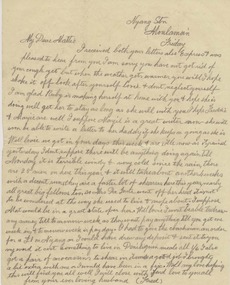
Letters sent to Martha (Mattie) dated from 1907 to 1920. Each letter is an edited version of the original pertaining to aspects of Fred Myers life as a shearer. Cobran Stn via Deniliquin Thursday Sept 1st 1910 …I got a reply from Eynesbury and a favourable reply, it starts on the 13th Oct so I will have plenty of time to get there, in fact far to much as we will finish here in a month full time so that will leave a fortnight to spare. We got rain here at last and it has put us back considerably as we only worked Monday. I have been idle ever since. We will probably start again Saturday. The weather has taken up nice and fine again…. I hope it will keep up to the cut out now I have 800 sheep shorn up to date and am fifth among thirty men so I’m doing well I think. Did you get the pound I sent? I’m sending two more this time, which I drew on Saturday. I don’t like sending too much as there is a chance of it going astray. Postcard Cobran Sept 18 1910 Just a note to let you know I am all right. I was disappointed not getting a letter yesterday, Saturday…I won’t get it now till next Saturday. We have three weeks here yet. I am sending 2 and tell me if you got the other 1. Cobran Stn via Deniliquin NSW Sunday 21st August (1911) ..I’m having a good time here, a good cook and the best of everything, no fires to lights or kettles to boil just get up and wire in but plenty of hard work. The sheep here a pretty rough but much better than Wandook. I am well among them here we had a little rain on Friday but not enough to stop us so we have got one full week in and the weather is now lovely I have been basking in the sunshine all morning and feel strong and fit as a fiddle. They are all a grand lot of men here I only knew one out of the lot but now them all pretty well now. We have a bit of a concert here every night almost. There are a few good singers here and we also had a phonograph up from the station with all the latest records. We have has two dances amongst ourselves, very boisterous affairs indeed they do make the dust fly. I have not ventured to take part in them yet and don’ think I will either. I get enough dancing all day long and besides I have to furnish the music. You ought to see them going when I rattle up the concertina they do make the dust fly. Sample of letters written by Fred Myers to his wife Mattie Myerslocal identities -
 Bendigo Military Museum
Photograph - PHOTOGRAPHS, NAVY WW2, c.WWII
Photographs collected by Earnest Albert Simmons W/2129 Royal Australian Navy. Enlisted 30 June 1941 and discharged 14 October 1946 with the rank of Leading Stoker. Posting at discharge was HMAS Lonsdale..1) Ship .2) Submarine conning tower .3) Ship .4) Hospital ship .5) Ship at anchor .6) Launch at ships side .7) Ships at anchor .8) Sunken ship .9) Ship .10) Group on launch .11) Ship firing a broadside .12) Wooden sailing vessel .13) Ship .14) Ship .15) Pilot station .16) Ship .17) Ship .18) Ship.s deck and biplane .19) Partially sunken ship .20) Two ships .21) Ship .22) Ship - damaged .23) Ship .24) Statue and colonade .25) Searchlights .26) Ships deck at sea .27) Aircraft .28) Ship .29) Ship .30) Troop ship .31) Swimmers at ships side .32) Ship .33) Ship .34) Ship deck at sea .35) Ship .36) Submarine .37) Ship .38) Ship .39) Ship .40) Two ships at sea .41) Ship .42) Aircraft carrier .43) Ships symbol .44) Sketch of Berbera .45) Sketch of biplanes .46) Boat at pier .47) Tug boat .48) Ship .49) Ship at wharf .50) Ships at wharf .51) Aircraft carrier .52) Ship .53) Ship at wharf .54) Ships at wharf .55) Ship .56) Two ships .57) Tug boat .58) Diagram comparing the size of two ships .59) Ship sailing past lighthouse .60) Postcard HMAS "Stuart". .1) Hobart and Glascow at Colombo .2) British submarine returning to Alexandria after claiming a victory - note Skull and X Bones .3) HMS Glascow at Colombo .4) Ex Italian hospital ship taken over by British. RAMB II .5) HMS Exeter .6) The landing party returning .7) Part fleet at Colombo .8) British ammunition ship sunk by sabotage in Alex Harbour .9) HMS Exeter .10) On the approach of the island. Note twin Lewis guns .11) HMS Ajax bombarding Bardia .12) A native boat used along coasts and Indian Ocean .13) RMS Georgie refoated at Pt? 1941 .14) HMS Carthage .15) Pilot station at Colombo .16) Aquitania .17) Ajax on patrol with Hobart and battle fleet .18) Hobart rolling in the Bight .19) HMS Gnat (river gun boat) hit by torpedo at Tobruk .20) - .21) Mauritania .22) Italian cruiser sunk by HMAS Sydney .23) Greek destroyer .24) Memorial of Mohomed Pasha Alexandria. Presented by Musso .25) Searchlight at Alexandria .26) Hobart pile driving in heavy weather .27) Lockheed Hudson dive bombing .28) - .29) HMS Galatea? x 1 turret at stern .30) Troops on Aquitania .31) Boys swimming in the middle lakes at Ismalia in the centre of Sues Canal .32) A water NG ? .33) - .34) Hobart striking heavy weather .35) HMS Jupiter .36) British submarine entering Alex .37) Queen Mary .38) Queen Elizabeth .39) Nieuw Amsterdam .40) - .41) Achilles .42) HMS Aircraft carrier - Illustrious .43) Symbol of Hobart's Pom-Pom .44) - .45) - .46) - .47) - .48) Mohoja and Oronties .49) Mohoja .50) - .51) - .52) HMAS Murchison 1954 .53) Strathmore .54) - .55) - .56 - .57 - .58) HMAS Vendetta .59) HMAS Cowra .60) - photographs, ran, hmas