Showing 1144 items
matching west side
-
 Phillip Island and District Historical Society Inc.
Boomerang, Unknown
Beaked Boomerang ornamented with red ochre, fine grooves on obverse side. This is a special form of Boomerang used in fighting at close quarters or as a missile. The purpose of the beak is to catch on any defensive object being used by the person under attack. Used as items of trade - is made by tribes in West Queensland and Northern Central Australia.australian aboriginal history, aboriginal artifact, boomerang -
 Phillip Island and District Historical Society Inc.
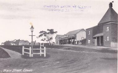
Photograph, Thompson Ave, Cowes Phillip Island, 1920
View looking up Thompson Avenue from The Esplanade. The Chicory Kiln built in 1870, a two storey brick building is adjoined by West's General Store, built in 1869 to cater for the needs of the Settlers. A large Gum Tree and finally houses follow on from these two buildings. In the foreground and to the left, is a small three sided fence and a gracious Gas Lamp on long pole.Cowes looking up Thompson Ave to Chapel Street. 1905Main Street Coweslocal history, photographs, streetscape, cowes, black & white photograph, mary robb -
 Phillip Island and District Historical Society Inc.
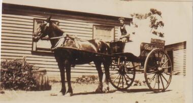
Photograph, Bakery, Thompson Ave, Cowes Phillip Island, 1920
In front of Bakehouse, a wooden building with two closed windows, is harnessed horse and buggy. Seated on the two-wheeled buggy is probably one of the West brothers. A tree in background is partially obscured.Horse an Baker's Buggy outside Bakery in Thompson Avenue, Cowes.On side of Buggy - H E West. Bakery (another word undecipherable)local history, photographs, thompson avenue, cowes, horse & buggy, sepia photograph, mary robb -
 Phillip Island and District Historical Society Inc.
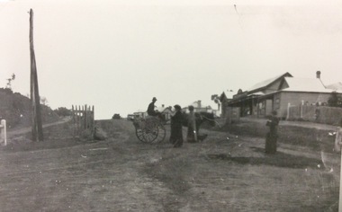
Photograph, Cowes main street
Part of a collection of 'Rose & Valentine' series of Post Cards. Copied by John Jansson 1984Black & White Post Card of Main Street, Cowes. Ladies & man on buggy in foreground. Wests General Store on right hand side of road.local history, photography, photographs, postcards, cowes, phillip island, black & white photograph, thompson ave cowes, wests general store -
 Phillip Island and District Historical Society Inc.
Photograph
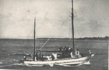
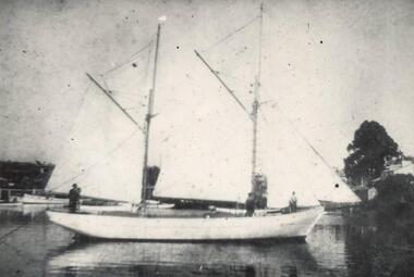
One of a collection of over 400 photographs in an album commenced in 1960 and presented to the Historical Society by the Shire of Phillip IslandPhotograph of W. J. Kennon's Excursion Schooner "Royal" Starboard side. This boat was lengthened by 10 feet, the section being fitted amidships.local history, photography, photographs, boats, excursion schooner "royal", black & white photograph, shipping, schooners, w j kennon, schooner "royal", john jenner, bryant west -
 Phillip Island and District Historical Society Inc.
Photograph
... ivy florence John Jenner Bryant West Photograph of W. J ...One of a collection of over 400 photographs in an album commenced in 1960 and presented to the Historical Society by the Shire of Phillip IslandPhotograph of W. J. Kennon's two masted Schooner "Ivy Florence" starboard sidelocal history, photography, photographs, film maritime technology, boats, schooner "ivy florence", black & white photograph, shipping, schooners, w j kennon, ivy florence, john jenner, bryant west -
 Phillip Island and District Historical Society Inc.
Photograph
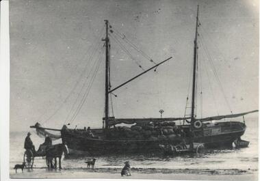
One of a collection of over 400 photographs in an album commenced in 1960 and presented to the Historical Society by the Shire of Phillip IslandPhotograph of freight vessel "Vision" beached in surf at Ventnor Beach - port side - with two horses and drays and men loading bags of Chicory and Onions - three dogs. Ventnor beach was used when wharf charges were high.local history, photography, photographs, film maritime technology, cargo handling, freighter "vision" - loading chicory and onions, black & white photograph, freight vessel vision, ventnor beach, chicory and onions, horses and drays, john jenner, bryant west -
 Phillip Island and District Historical Society Inc.
Photograph
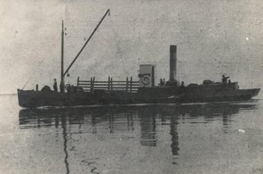
One of a collection of over 400 photographs in an album commenced in 1960 and presented to the Historical Society by the Shire of Phillip IslandPhotograph of SS "Oscar" - port side. Some crew visible. The old "Oscar" was renamed "Ventnor".local history, photography, photographs, maritime technology, boats, ss "oscar", black & white photograph, shipping, ss oscar renamed ventnor, john jenner, bryant west -
 Phillip Island and District Historical Society Inc.
Photograph
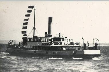
... killara john jenner bryant west Port side Photograph of Vehicular ...One of a collection of over 400 photographs in an album commenced in 1960 and presented to the Phillip Island & Westernport Historical Society by the Shire of Phillip IslandPort side Photograph of Vehicular ferry SS "Killara" at speedlocal history, photography, photographs, film maritime technology, ferries, ss "killara", black & white photograph, shipping, ss killara, john jenner, bryant west -
 Phillip Island and District Historical Society Inc.
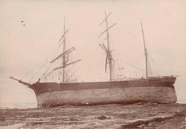
Photograph, 1901
One of a collection of over 400 photographs in an album commenced in 1960 and presented to the Phillip Island & Westernport Historical Society by the Shire of Phillip IslandSepia photograph taken from port side showing the Three Masted Barque "Artisan" high and dry on the rocks at Cape Paterson. 1901.local history, photography, photographs, wrecks, sailing ship "artisan" wrecked at cape paterson, sepia photograph, shipping, ship wrecks, sailing ship artisan, cape paterson, john jenner, bryant west -
 Phillip Island and District Historical Society Inc.
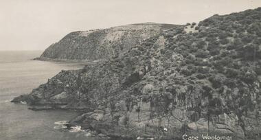
Photograph, Bryant West
One of a collection of over 400 photographs in an album commenced in 1960 and presented to the Phillip Island & Westernport Historical Society by the Shire of Phillip IslandPhotograph of Cliff Formation east side - Cape Woolamai.local history, photography, photographs, coastline, cape woolamai, phillip island, cliffs, john jenner, bryant west -
 Phillip Island and District Historical Society Inc.
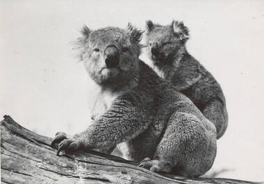
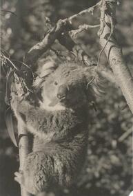
Photograph
... Bryant West Side on Photograph of an adult Koala with young ...One of a collection of over 400 photographs in an album commenced in 1960 and presented to the Phillip Island & Westernport Historical Society by the Shire of Phillip IslandSide on Photograph of an adult Koala with young on back sitting on a log.local history, photography, photographs, koala & young, black & white photograph, wild life, koalas, wildlife - koala, john jenner, bryant west -
 Phillip Island and District Historical Society Inc.
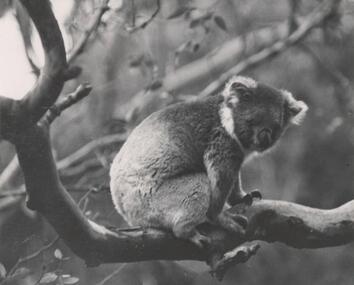
Photograph
... photograph koalas Wildlife - Koala John Jenner Bryant West Side ...One of a collection of over 400 photographs in an album commenced in 1960 and presented to the Phillip Island & Westernport Historical Society by the Shire of Phillip IslandSide on Photograph of a Koala sitting on a horizontal tree limb.local history, photography, photographs, koala, black & white photograph, koalas, wildlife - koala, john jenner, bryant west -
 Phillip Island and District Historical Society Inc.
Photograph
... photograph wild life koalas Wildlife - Koala John Jenner Bryant West ...One of a collection of over 400 photographs in an album commenced in 1960 and presented to the Phillip Island & Westernport Historical Society by the Shire of Phillip IslandSide on Photograph of a Koala clinging to a vertical tree limb and chewing on a leaf.local history, photography, photographs, koala, black & white photograph, wild life, koalas, wildlife - koala, john jenner, bryant west -
 Phillip Island and District Historical Society Inc.
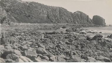
Photograph, Bryant West
One of a collection of over 400 photographs in an album commenced in 1960 and presented to the Phillip Island & Westernport Historical Society by the Shire of Phillip IslandPhotograph of Rocks and Beach south side of Cape Woolamai.local history, photography, photographs, coastline, rocky beach, reef, cape woolamai, phillip island, reefs, john jenner, bryant west -
 Phillip Island and District Historical Society Inc.
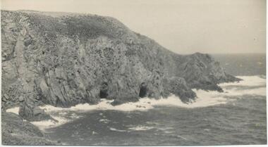
Photograph, Bryant West
One of a collection of over 400 photographs in an album commenced in 1960 and presented to the Phillip Island & Westernport Historical Society by the Shire of Phillip IslandPhotograph of waterline with caves southwest side of Cape Woolamai.local history, photography, photographs, coastline, cape woolamai, phillip island, caves, john jenner, bryant west -
 Phillip Island and District Historical Society Inc.
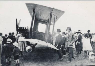
Photograph, 1920
... photograph air transport bi planes John Jenner Bryant West Side view ...One of a collection of over 400 photographs in an album commenced in 1960 and presented to the Phillip Island & Westernport Historical Society by the Shire of Phillip IslandSide view of aeroplane surrounded by spectators - 1920local history, photography, aeroplane, black & white photograph, air transport, bi planes, john jenner, bryant west -
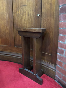 Mission to Seafarers Victoria
Furniture - Credence, c. 1917
A credence is small table placed within the sanctuary of a church and near the wall at the Epistle side, for the purpose of holding the utensils required for the celebration of the Eucharist. From the 1917 list of gifts, the credence was donated by Captain and Mrs C.D. Goldsmith, brother of Reverend Gurney Goldsmith. Cecile De la Mare Goldsmith was born in 1861 in West Brompton and was in The Royal Naval Reserve (RNR) during WWI. He died on 21 January 1917 Commander RNR & late Master in the P.O. Service died at Madeira while acting as his Majesty's Vice Consul. He's buried in Funchal (Portugal).Small credencegifts-1917, cecil de la mare goldsmith (1862-1917), c.d. goldsmith, rnr, royal naval reserve -
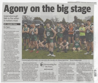 Greensborough Historical Society
Newspaper Clipping, Diamond valley Leader, Agony on the big stage, 25/09/2019
Greensborough fails to fire when it matters most. The seniors and reserves sides had lost just one game between them before Saturday, with both enduring stunning upset defeats in their respective NFL Division 1 grand finals.News article 1 page, black text.northern football league, greensborough football club, west preston-lakeside football club -
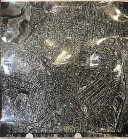 Greensborough Historical Society
Aerial Photograph, Yan Yean M/S 7922 Run 17 No. 3833-20, 01/11/1984
Covers Rosanna and parts of Viewbank and Heidelberg. East boundary Price Park; West boundary Hurstbridge railway lineLaminated black and white aerial photograph; adjoins 6226 on east siderosanna, viewbank, heidelberg -
Glenelg Shire Council Cultural Collection
Flyer - Flyer - 'Discovery', 2008
Dh flyer promoting the world premiere performance of 'Discovery' - a choral symphony in a four movements, celebrating the great south west walk. Flyer is made of card, a French horn on red material and grey section with into re performance, on one side of flyer. Reverse has photo of section of great south west walk and description of event, and major sponsor logos. -
Glenelg Shire Council Cultural Collection
Postcard, n.d
Buff coloured cardboard folder, with a strip of black and white postcard size views of Portland, 6 on each side. Red 21/2 penny stamp. Addressed to 'Miss M. Kerr, "Cherrywood" West Portland'. Inside cover of folder 'Wishing all at Cherrywood a Merry Xmas from Stan, Rae & the girls' - handwrittenFront: 'ROSE SERIES picturesque views of Portland, Australia' For E.M. JENKIN, BENTINCK AND JULIA STS. PORTLAND' -
Glenelg Shire Council Cultural Collection
Photograph - Photograph - aerial view of Portland coast, c. 1954
Black and white aerial photograph of coastline around Portland. Black border, scale all sides, 5 rows of 3 't' at regular intervals. Ocean, land with lakesFront: '820 -8' - handwritten, white, lower border 'RUN 5' 'PORTLAND', printed, white, lower borderaerial photography, central portland, portland harbour, south west coastline -
Glenelg Shire Council Cultural Collection
Photograph - Photograph - aerial view of Portland, c. 1954
Black and white aerial photograph of coastline around Portland. Black border, scale all sides, 5 rows of 3 't' at regular intervals. Ocean on left, land on rightFront: '607 - 54 ' - handwritten, white, border 'RUN 7' 'PORTLAND', printed, white, borderaerial photography, central portland, portland harbour, south west coastline -
Glenelg Shire Council Cultural Collection
Photograph - Photograph - aerial view of Portland coastline, c. 1954
Black and white aerial photograph of coastline around Portland. Black border, scale all sides, 5 rows of 3 't' at regular intervals. Mostly ocean, small area of land top left. See Other Information.Front: '820 - 47' - handwritten, white, border 'RUN 6' 'PORTLAND', printed, white, borderport of portland archives, aerial photography, portland harbour, south west coastline -
Glenelg Shire Council Cultural Collection
Photograph - Photograph - aerial view of Portland, c. 1954
Black and white aerial photograph of coastline around Portland. Black border, scale all sides, 5 rows of 3 't' at regular intervals. Half ocean, half land, separated by beach, further left than 8472Front: '607 - 91 ' - handwritten, white, border 'RUN - 6 PORTLAND', printed, white, borderaerial photography, central portland, portland harbour, south west coastline -
Glenelg Shire Council Cultural Collection
Photograph - Photograph - aerial view of Portland, c. 1954
Black and white aerial photograph of coastline around Portland. Black border, scale all sides, 5 rows of 3 't' at regular intervals. Ocean at right, land on left.Front: '820 - 7' -- handwritten, white, lower border 'RUN 5' 'PORTLAND', printed, white, lower borderaerial photography, central portland, portland harbour, south west coastline -
Glenelg Shire Council Cultural Collection
Photograph - Photograph - aerial view of Portland coastline, c. 1954
Black and white aerial photograph of coastline around Portland. Black border, scale all sides, 5 rows of 3 't' at regular intervals. 10% ocean, 90% land. See 'Other Information'Front: '820- 52' - handwritten, white, border 'RUN 6' 'PORTLAND', printed, white, borderport of portland, aerial photography, south west coastline -
Glenelg Shire Council Cultural Collection
Photograph - Photograph - aerial view of Portland, c. 1954
Black and white aerial photograph of coastline around Portland. Black border, scale all sides, 5 rows of 3 't' at regular intervals. 25% ocean, 75% land. See 'Other Information'Front: '820 - 50' - handwritten, white, border 'RUN 6' 'PORTLAND', printed, white, borderaerial photography, central portland, portland harbour, south west coastline -
Glenelg Shire Council Cultural Collection
Photograph - Photograph - aerial view of Portland, c. 1954
Black and white aerial photograph of coastline around Portland. Black border, scale all sides, 5 rows of 3 't' at regular intervals.Mostly ocean, strip of land down right hand edge and across bottom.Front: '607 - 55 ' - handwritten, white, border 'RUN 7 'PORTLAND', printed, white, borderaerial photography, central portland, portland harbour, south west coastline