Showing 576 items matching "yarra yarra district"
-
 Eltham District Historical Society Inc
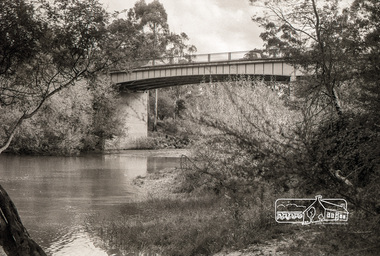
Negative - Photograph, Russell Yeoman, Warrandyte Bridge over Yarra River, c.1970
Roll of 35mm black and white negative film, 4 of 7 strips Associated printIlford HP4bridge, warrandyte, bridges, kangaroo ground road, yarra river -
 Eltham District Historical Society Inc
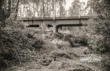
Photograph, Russell Yeoman, Yarra Glen Road Bridge over Watsons Creek, Kangaroo Ground, c.1970, 1970c
Concrete bridge built in the 1920s.Roll of 35mm black and white negative film, 4 of 7 stripsIlford HP4bridge, bridges, watsons creek, eltham-yarra glen road, yarra glen road, kangaroo ground -
 Eltham District Historical Society Inc
Photograph, Yarra Glen, 1986, 1986
Originally contained in a 'magnetic' photo album of scenic photos of Yan Yean and Warrandyte believed to be donated by Mrs Eric Stephenson, Jingalong, 110 Ryans Road, Eltham, Vic. 3095; relocated to archival safe storage.Colour photographyarra glen -
 Eltham District Historical Society Inc
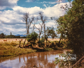
Photograph, Fred Mitchell, Approaching storm, Yarra Valley, Tarrawingee, 1990, 1990
Home of Frederick William Mitchell, chemical engineer and his wife, Marjorie Nell Mitchell, teacher.Digital copy of colour photographfred mitchell collection, yarra valley, tarrawingee, 1990 -
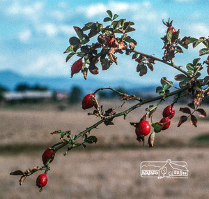 Eltham District Historical Society Inc
Photograph, Fred Mitchell, Rose-hips, Yarra Glen, 1991, 1991
Digital copy of colour photographfred mitchell collection, 1991, yarra glen -
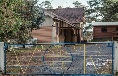
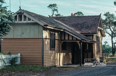 Eltham District Historical Society Inc
Photograph, Fred Mitchell, Yarra Glen Railway Station, 1991, 1991
Digital copy of colour photographfred mitchell collection, 1991, yarra glen railway station -
 Eltham District Historical Society Inc
Photograph, Fred Mitchell, Yarra Glen Railway Station, 1991, 1991
Digital copy of colour photographfred mitchell collection, 1991, yarra glen railway station -
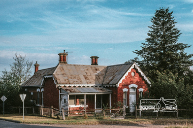 Eltham District Historical Society Inc
Photograph, Fred Mitchell, Old brick home, Yarra Glen, 1991, 1991
Digital copy of colour photographfred mitchell collection, 1991, yarra glen, houses -
 Eltham District Historical Society Inc
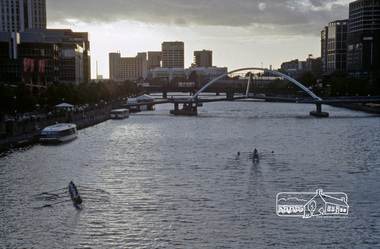
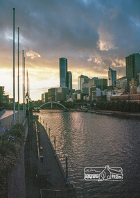
Photograph, Fred Mitchell, Yarra River from Princes Bridge, Melbourne, 1996, 1996
Digital copy of colour photographfred mitchell collection, 1996, melbourne, yarra river -
 Eltham District Historical Society Inc
Photograph, Fred Mitchell, Yarra River from Princes Bridge, Melbourne, 1996, 1996
Digital copy of colour photographfred mitchell collection, 1996, melbourne, yarra river -
 Eltham District Historical Society Inc
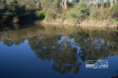
Photograph, Fred Mitchell, Tree reflections in the Yarra River at the confluence with the Diamond Creek, Eltham Lower Park, 23 June 2013, 23/06/2013
Digital copy of colour photographfred mitchell collection, 2013, eltham lower park, confluence, diamond creek, yarra river -
 Eltham District Historical Society Inc
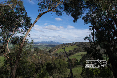
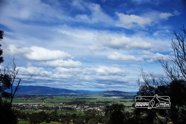
Photograph, View from Breakneck, Yarra Glen, 27 August 2016, 27/08/2016
... and Present (Yarra Glen District Historical Society), 2004.... and Present (Yarra Glen District Historical Society), 2004. fred ..."Until 1865, all wheeled traffic to the Upper Yarra District passed through Christmas Hills along present day Ridge and Muir roads, then followed the hazardous course of "The Breakneck" (now Breakneck Road) to the valley below. To slow the descent of wagons, logs are said to have been dragged behind. In 1865, an easier route was opened on the south side of the Yarra River, and led to the birth of Lilydale". - Christmas Hills Past and Present (Yarra Glen District Historical Society), 2004.Digital copy of colour photographfred mitchell collection, 2016, breakneck, yarra glen -
 Eltham District Historical Society Inc
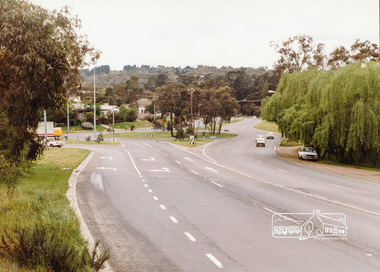
Photograph, Main Road-Fitzsimons Lane Roundabout, c. Oct 1987, 1987
Fitzsimons Lane was originally known as the Eltham-Templestowe Road north of the Yarra and Fitzsimons Lane south of the Yarra River. Date based on other similar display panels visible in images of the Shire of Eltham display at the Eltham Community Festival, 7 November 1987Colour photographdisplay panel, eltham festival, infrastructure, shire of eltham, main road, roundabouts, fitzsimons lane -
 Eltham District Historical Society Inc
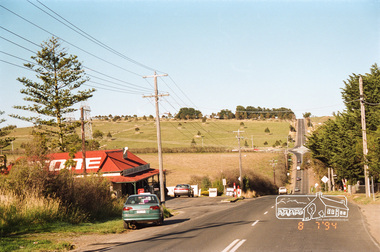
Photograph, Looking south towards the Kangaroo Ground Store, Eltham-Yarra Glen Road, Kangaroo Ground, 8 July 1994, 08/07/1994
Roll of 35mm colour negative film, 4 stripsFuji 100kangaroo ground, eltham-yarra glen road, kangaroo ground store -
 Eltham District Historical Society Inc
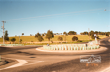
Photograph, Looking south-east at the intersection of Eltham-Yarra Glen Road and Kangaroo Ground-Warrandyte Road, Kangaroo Ground, 8 July 1994, 08/07/1994
Roll of 35mm colour negative film, 4 stripsFuji 100kangaroo ground, eltham-yarra glen road, kangaroo ground-warrandyte road -
 Ringwood and District Historical Society
Map, Plan of the Parish of Warrandyte County of Evelyn - 1841
Blueprint copy of Survey Map W27 detailing original Selectors' names and property locations between Yarra Yarra River (Warrandyte) and Mullum Mullum Creek (Ringwood). List of Parish map references including property bearings, distances in Links, and markings on trees. Pound Bend area of Warrandyte marked as Reserve For Aborigines. Descriptive remarks include areas marked "scrubby, flat, sandy soil". Several other references faded and illegible.(Map) by T.H. Nutt Feb 3 1841. -
 Ringwood and District Historical Society
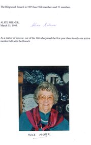
Literary work, Alice Milner's memories of CWA Ringwood Branch in 1995
Kindly scanned from Ringwood Branch archival collectionTranscript (kindly completed by Ken Briscoe using ChatGPT) RINGWOOD BRANCH COUNTRY WOMEN'S ASSOCIATION INC. February 13, 1946 in the Ringwood Town Hall, the Mayoress, Mrs. H.E. Parker, called the meeting and Ringwood Branch Country Women's Association was formed, and would be in the Yarra Valley Group. Speaker for the day was Mrs. Wray, Group President, Yarra Valley Group. Office bearers elected were: • Mrs. Greenshields (President) • Mrs. Shields (Secretary) • Mrs. Roberts (Treasurer) At the inaugural meeting, 93 ladies joined, and the first general meeting of the Ringwood Branch was held March 7, 1946, and by the end of August the membership grew to 160. In 1946 the joining fee was 4/- and you never attended a meeting unless you wore hat and gloves. The first year, meetings were held in the main Town Hall, then they were transferred to the small hall, which had a creche next door, at the baby health centre, where mothers could leave their little ones, while mum enjoyed the meetings, demonstrations or entertainment. The Branch had a very good Choir, conducted by Mrs. Dorrie Davidson, also a very talented theatrical group. Each birthday they put on excellent stage shows, some beautiful costumes being hired from well-known Melbourne theatrical company. The 1956 Olympic stage show had some well-trained, but out of form, athletes. Highlight of the year was the Annual Ball and two Debutante Balls. New branches were formed in the district, Everard, East Ringwood, Heathmont, South Warrandyte. There was also, Ringwood Younger set, a night branch (later years was renamed Marana). It was then that our membership dropped. As more and more branches were started in the district, Ringwood was then allocated to the newly formed Maroondah Highway Group. Craft classes and demonstrations were of a high standard, with some interesting things being made such as millinery, dressmaking, pottery, etc. In 1960 when Ringwood was made a City, a C.W.A. float was entered in the procession, this was a mammoth task, as hundreds of flowers were made and wired to the float, which was in green and gold C.W.A. colours. The time came when the Town Hall was to be demolished, and we moved to the Church of England Hall, Civic Place, but after a short time, this hall was also demolished. Meetings were then held at Ringwood Library until the library was no longer available. Our last move was to our present meeting room at Lionswood. Today you dress as you wish and membership is $12.00. The Ringwood Branch in 1995 has 2 life members and 21 members. Alice Milner March 15, 1995 As a matter of interest, of those 160 members who joined in the first year, only one active member is left with the Branch -
 Ringwood and District Historical Society
Photograph, Warrandyte Historical Society Newsletters nos. 76-84
Digitised WHS newsletters from December 1990 (no. 76) to October 1990 (no. 84). Sent to Secretary of the Ringwood Historical Research Group, Jack Lindsay.Noteable articles:- Earl Stewart bus service Brackenbury Street Yarra Yarra Mining Company Dr Owen's Puddling Machine 1927 bushfires Schult Steven Houghton Taffy Jones Great Southern Hill Caledonia Gold Mine Mary Hill - South Warrandyte Post Office Artists - Nutter Buzacott, Frank Crozier, Penleigh Boyd, William Frater, Christine Gray-Aldor Warrandyte Primary School Potter's Cottage -
 Yarra Ranges Regional Museum
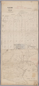
Map, District of Yering, 1 Dec 1885
Canvas backed paper map of District of Yering, Country of Evelyn, showing proposed waterworks for township of Lilydale. Signed by Hodgson & Smith, water supply engineers. Proposed waterworks for the township of Lilydale. Signed by Hodgson & Smith, water supply engineers. Proposed water main shown with of reservoir etc. Canvas backed paper map of District of Yering, Country of Evelyn, showing proposed waterworks for township of Lilydale. Signed by Hodgson & Smith, water supply engineers. Proposed waterworks for the township of Lilydale. Signed by Hodgson & Smith, water supply engineers. Proposed water main shown with of reservoir etc. evelyn, lilydale, waterworks and irrigation -
 Whitehorse Historical Society Inc.
Mixed media - Audio Cassette, Talk - Water in the Eastern Suburbs, 12/04/2003
... Yarra Valley Water Water Nunawading & District Historical ...Cassette of a talk to the Society by David Elliott from Yarra Valley Water on the 'History of the Provision of Water in the Eastern Suburbs' on 12 April 2003.Cassette of a talk to the Society by David Elliott from Yarra Valley Water on the 'History of the Provision of Water in the Eastern Suburbs' on 12 April 2003.elliott, david, yarra valley water, water, nunawading & district historical society -
 Mt Dandenong & District Historical Society Inc.
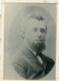
Photograph, Thomas Hand 1839-1888
Copy of a formal photograph showing head and shoulders of Thomas Hand, 1839-1888. This photograph has a detailed inscription on the back handwritten by John Lundy-Clarke in 1974.Thomas Hand 1839-1888 Surveyor for Upper Yarra Road Board 1862-1872. Engineer for Shire of Lillydale 1872-1888. Father of Kate, Eva, Eliza, Florence, Mabel, Alice, Frederick and William. Married Eliza Erith 1862. Owner of “Mountain Grange” in the present district of Kalorama. Copy of photograph in possession of his daughter Mabel made by JLC in 1974. thomas hand, mountain grange -
 Kew Historical Society Inc
Photograph, J F C Farquhar, Railway Bridge Over the Yarra, 1891
At the beginning of the 1890s, the Kew businessman and Town Councillor, Henry Kellett, commissioned J.F.C. Farquhar to photograph scenes of Kew. These scenes included panoramas as well as pastoral scenes. The resulting set of twelve photographs was assembled in an album, Kew Where We Live, from which customers could select images for purchase.The preamble to the album describes that the photographs used the ‘argentic bromide’ process, now more commonly known as the gelatine silver process. This form of dry plate photography allowed for the negatives to be kept for weeks before processing, hence its value in landscape photography. The resulting images were considered to be finely grained and everlasting. Evidence of the success of Henry Kellett’s venture can be seen today, in that some of the photographs are held in national collections.It is believed that the Kew Historical Society’s copy of the Kellett album is unique and that the photographs in the book were the first copies taken from the original plates. It is the first and most important series of images produced about Kew. The individual images have proved essential in identifying buildings and places of heritage value in the district.Completed in November 1890, the railway viaduct (now the Chandler Highway Bridge) linked Kew and Fairfield. The viaduct is significant as the most substantial extant engineering remnant of the Outer Circle Railway Line. Opened in March 1891, the viaduct crossed the Yarra River in a single span, atop three supporting brick pillars. Following the closure of the railway line in 1927, and the construction of the Chandler Highway in 1930, the bridge was used for vehicular traffic. In 1891 when this panoramic photograph was taken, the grounds of what was then the Kew Lunatic Asylum extended down to the River and eastward beyond the viaduct. The landscape surrounding the Asylum was planted with traditional exotic trees such as Oaks, Pines and Cedars, and landmark trees from northern Australia such as the Hoop Pine. Remnant indigenous trees such as the River Red Gum, Yellow Box and Lightwood were scattered around the site, including beside the Yarra River.Railway Bridge Over the Yarrakew illustrated, kew where we live, photographic books, henry kellett, railway viaduct - - kew (vic) -
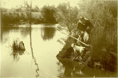 Kew Historical Society Inc
Photograph, J F C Farquhar, Ratting on the Yarra, 1891
At the beginning of the 1890s, the Kew businessman and Town Councillor, Henry Kellett, commissioned J.F.C. Farquhar to photograph scenes of Kew. These scenes included panoramas as well as pastoral scenes. The resulting set of twelve photographs was assembled in an album, Kew Where We Live, from which customers could select images for purchase.The preamble to the album describes that the photographs used the ‘argentic bromide’ process, now more commonly known as the gelatine silver process. This form of dry plate photography allowed for the negatives to be kept for weeks before processing, hence its value in landscape photography. The resulting images were considered to be finely grained and everlasting. Evidence of the success of Henry Kellett’s venture can be seen today, in that some of the photographs are held in national collections.It is believed that the Kew Historical Society’s copy of the Kellett album is unique and that the photographs in the book were the first copies taken from the original plates. It is the first and most important series of images produced about Kew. The individual images have proved essential in identifying buildings and places of heritage value in the district.In Farquhar’s close-up portrait of the rat catcher and his dog, the photographer excludes any extraneous data that otherwise might have provided a spatial or motivational context. The contemporary or the present day viewer is required to construct a narrative to explore or understand what is occurring. The title of the picture might incline a viewer to believe that what they see is an exercise in vermin control, and that the rat concerned might be an introduced black or brown rodent. A more likely scenario is that the rat catcher is focussed on catching ‘rakali’, a native water-rat once widely trapped for its fur. The trapping of rakali for use in the manufacture of fashionable clothing accelerated as introduced furs such as musquash became more expensive. It was not until 1938 that rakali were granted protected status.Ratting on the Yarrakew illustrated, kew where we live, photographic books, henry kellett, yarra river -
 Kew Historical Society Inc
Photograph, J F C Farquhar, Dight's Falls, 1891
At the beginning of the 1890s, the Kew businessman and Town Councillor, Henry Kellett, commissioned J.F.C. Farquhar to photograph scenes of Kew. These scenes included panoramas as well as pastoral scenes. The resulting set of twelve photographs was assembled in an album, Kew Where We Live, from which customers could select images for purchase.The preamble to the album describes that the photographs used the ‘argentic bromide’ process, now more commonly known as the gelatine silver process. This form of dry plate photography allowed for the negatives to be kept for weeks before processing, hence its value in landscape photography. The resulting images were considered to be finely grained and everlasting. Evidence of the success of Henry Kellett’s venture can be seen today, in that some of the photographs are held in national collections.It is believed that the Kew Historical Society’s copy of the Kellett album is unique and that the photographs in the book were the first copies taken from the original plates. It is the first and most important series of images produced about Kew. The individual images have proved essential in identifying buildings and places of heritage value in the district.Dight’s Falls in Studley Park is an artificial weir built on a natural rock bar across the Yarra. The weir was built in the 1840s to provide water to the ‘Ceres’ flour mill, one of the earliest industrial sites in Melbourne. The falls were later to be named after the owner of this mill. In 1888, William Guilfoyle, Director of the Melbourne Botanical Gardens had called for fresh water to be piped from above the weir to the Botanical Gardens, using a pumping station on the Kew side of the Falls, a holding reservoir in Walmer Street and a series of pipes from there to the Gardens. This system was opened in May 1891. Farquhar’s photograph of the man-made weir obscures the industrial activity on both sides of the Falls and focusses solely on the river and the surrounding natural vegetation. The photograph probably predates the disastrous flooding of the Yarra River in July 1891, the greatest to have occurred in the Colony since the foundation of Melbourne.Dight's Fallskew illustrated, kew where we live, photographic books, henry kellett, yarra river -
 Kew Historical Society Inc
Photograph, J F C Farquhar, The Yarra in Hyde Park, 1891
At the beginning of the 1890s, the Kew businessman and Town Councillor, Henry Kellett, commissioned J.F.C. Farquhar to photograph scenes of Kew. These scenes included panoramas as well as pastoral scenes. The resulting set of twelve photographs was assembled in an album, Kew Where We Live, from which customers could select images for purchase.The preamble to the album describes that the photographs used the ‘argentic bromide’ process, now more commonly known as the gelatine silver process. This form of dry plate photography allowed for the negatives to be kept for weeks before processing, hence its value in landscape photography. The resulting images were considered to be finely grained and everlasting. Evidence of the success of Henry Kellett’s venture can be seen today, in that some of the photographs are held in national collections.It is believed that the Kew Historical Society’s copy of the Kellett album is unique and that the photographs in the book were the first copies taken from the original plates. It is the first and most important series of images produced about Kew. The individual images have proved essential in identifying buildings and places of heritage value in the district.Hyde Park is now a small recreation reserve bordered by Willsmere and Kilby Roads and White Avenue. In 1982, Hyde Park was cut off from the Yarra River by the construction of the Eastern Freeway. The building of the latter was to transform the natural landscape, including the Yarra, as well as Hyde Park. The construction of the Freeway makes it difficult to view the scene with the photographer’s eye. Today’s Hyde Park is located on land purchased in 1847 by John Cowell, and in 1851 Catherine Cowell, yet the scene selected by the photographer may well have been located on farmland owned by the Wills family. Farquhar’s point-of-view emphasises both the pastoral and recreational elements of the scene: the grazing cows, three boys, and in the distance two figures, seated on the bank with a parasol. By 1891, an environmental consequence of human activity, including farming, was deforestation, leading to the erosion of the south bank of the Yarra. In contrast, the land on the Alphington side of the river in 1891 included remnant bushland.The Yarra in Hyde Parkkew illustrated, kew where we live, photographic books, henry kellett, yarra river -
 Kew Historical Society Inc
Photograph - Flooding of the Yarra River in North Kew, 1934
North Kew, now divided between Kew and Kew East, bordered the Yarra River. As such, it was a region subject to flooding in the Yarra Valley. Development beyond this point (ie Kellett Grove) was limited by the City of Kew's planning regulations. Prior to urban development, the area since European settlement and the first land sales in the district in the 1840s, had been used for dairy farming. Small sepia snapshot taken from the river ramp of a house at 8 Kellett Grove, in what was then known as North Kew. The point of view is from a backyard looking towards Fairfield. Beyond the fence line are two almost submerged houses. A number of people are in a motor driven boat midstream. Fairfield at this period, (ie 1934) was noted for its limited river side development. Verso: 2/12/34 / TAKEN FROM OUR RAMPyarra river -- north kew, floods -- yarra valley, floods -- north kew, floods -- 1929, floods -- 1934, natural disasters -- kew -
 Kew Historical Society Inc
Photograph - 8 Kellett Grove, North Kew, 1929
North Kew, now divided between Kew and Kew East, bordered the Yarra River. As such, it was a region subject to flooding in the Yarra Valley. Development beyond this point (ie Kellett Grove) was limited by the City of Kew's planning regulations. Prior to urban development, the area since European settlement and the first land sales in the district in the 1840s, had been used for dairy farming. Small sepia snapshot taken of the front of 8 Kellett Grove, in what was then known as North Kew. Verso: 8 KELLETT GROVE / NORTH KEW / 1929 / 418 kellett gove -- north kew, californian bungalows, houses -- kellett grove -- kew (vic.) -
 Kew Historical Society Inc
Photograph - Flooding of the Yarra River in North Kew, 1934
North Kew, now divided between Kew and Kew East, bordered the Yarra River. As such, it was a region subject to flooding in the Yarra Valley. Development beyond this point (ie Kellett Grove) was limited by the City of Kew's planning regulations. Prior to urban development, the area since European settlement and the first land sales in the district in the 1840s, had been used for dairy farming. Small sepia snapshot taken from the back yard of a house at 8 Kellett Grove, in what was then known as North Kew. The point of view is from a backyard looking towards Fairfield. Floodwaters have submerged the fence and a clothes line. Verso: BACKYARD NTH. KEWyarra river -- north kew, floods -- yarra valley, floods -- north kew, floods -- 1934, natural disasters -- kew -
 Kew Historical Society Inc
Photograph - Flooding of the Yarra River in North Kew, 1934
North Kew, now divided between Kew and Kew East, bordered the Yarra River. As such, it was a region subject to flooding in the Yarra Valley. Development beyond this point (ie Kellett Grove) was limited by the City of Kew's planning regulations. Prior to urban development, the area since European settlement and the first land sales in the district in the 1840s, had been used for dairy farming. Small sepia snapshot taken from the back yard of a house at 8 Kellett Grove, in what was then known as North Kew. The point of view is from a backyard looking towards Fairfield. Verso: 8 KELLETT GROVEyarra river -- north kew, floods -- yarra valley, floods -- north kew, floods -- 1934, natural disasters -- kew