Showing 27615 items
matching yarra-river
-
 Orbost & District Historical Society
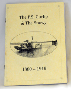
book, Winchester, Ian, The P.S. Curlip & the Snowy River 1880-1919, 2008
This book was written by Ian Winchester, the grandson of James Winchester, early settler in Marlo, who worked with Alan Richardson. The book is dedicated to those who colonised the Snowy River. James Winchester was born in Geelong in 1856. He first sailed into Marlo, aged 15 and returned in the 1870's. he worked on the snagging punt on the Snowy River and also on the Paddle Steamer Curlip which towed the barges to collect the maize grown along the Snowy River.This book is a useful reference on the history of the Paddle Steamer Curlip.A thin, 22 pp, stapled paperback book, titled "P.S. Curlip & The Snowy River". It has a cream cover with a b/w photo of the Paddle Steamer Curlip in the centre. Print is black. It contains a history of the Curlip built by Samuel Richardson and is written in verse. There are b/w photographs and sketches.On front page -stamped "Orbost & District Historical Society"winchester curlip snowy-river -
 Glenelg Shire Council Cultural Collection
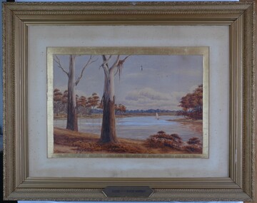
Painting, Scene on the River Murray, n.d
Art Collection Previously located in History HouseThe painting depicts a body of water with two large trees in the foreground. The two trees are situated on the left side of the riverbank which extends across the foreground of the work. The trees extend beyond the borders of the work with only a few branches visible at the top of the work. To the right of the trees, on the surfaceof the water, is a boat with a large white sail. The river bed continues on the left and right sides of the work and is covered with brown trees. The background features a distant view of the riverbank covered in blue trees. The work has a gilded ornate frame with cardboard and gilded mount and glass.Front: A.S. Murray plaque attached to frame: SCENE on the RIVER MURRAY Back: W. HAMER __________Street, Ballarat -
 Kiewa Valley Historical Society
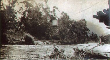
Photo - Tawonga Bridge.( Set of 2 photos)
Photo 1 - Rene Roper (Postmistress) crossing swollen Kiewa River on a milk can flying fox at Tawonga, during high winter waters Photo 2 - First Tawonga bridge was built in 1884- destroyed by floods in 1916. New bridge constructed 1923 and destroyed in 1953. Present concrete bridge constructed in 1986 and named Ryders BridgeBridge construction over Kiewa River at TawongaCopies of two original black and white photos. Photo 1 - Flying fox at site of Tawonga Bridge over the Kiewa River Photo 2 - Timber pile bridge over the Kiewa River at Tawongatawonga bridge, kiewa valley -
 Kew Historical Society Inc
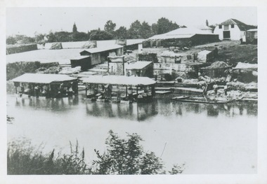
Print - 'Scouring Yards', River Yarra, Richmond
View of industry on the River Yarra at Richmond. The 'print' shows a number of buildings including pavilions built out into the water.Reverse: " Sheep pens / hide scouring plant on Yarra Richmond"scouring yards. - river yarra, industry -- river yarra -
 Eltham District Historical Society Inc
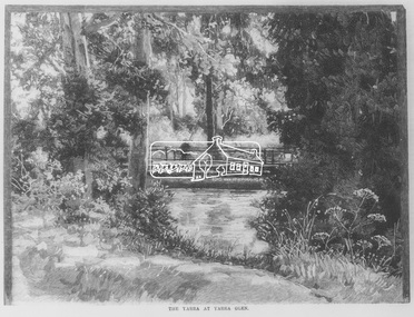
Negative - Photograph, Australasian Sketcher, The Yarra at Yarra Glen, 1889
"As the train on its journey from Melbourne to Healesville crosses the Yarra-flats, many glimpses are caught of the Yarra, sometimes between large belts of gumtrees, and splashing over boulders with is bosum covered with bubbles, dancing with sunlight, and racing each other until lost in the dark shadows of the wattles. Another turn catches it in a sombre mood, stealing slowly beneath some rustic bridge, whereon stands a patient fisherman waiting for a fish, which if the bait be correct, comes pretty frequently. Our illustration depicts one of these pretty nooks, and a very good idea is given of our picturesque river before it is polluted and turned into a sewer at Prince's Bridge."This photo forms part of a collection of photographs gathered by the Shire of Eltham for their centenary project book,"Pioneers and Painters: 100 years of the Shire of Eltham" by Alan Marshall (1971). The collection of over 500 images is held in partnership between Eltham District Historical Society and Yarra Plenty Regional Library (Eltham Library) and is now formally known as the 'The Shire of Eltham Pioneers Photograph Collection.' It is significant in being the first community sourced collection representing the places and people of the Shire's first one hundred years.Digital image 35mm Negativesepp, shire of eltham pioneers photograph collection, yarra glen, steels creek, cave hill -
 Kew Historical Society Inc
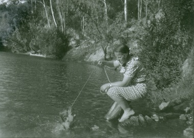
Photograph - Mother and child at the Yarra River, Kew, 1950s
Canoeing on the River Yarra was a recreational traditional pastime for the people of Kew and Melbourne since settlement in the 1830s. Later in the century, canoes were frequently hired from boathouses.Print enlargement. Woman beside river holding a piece of string. Child swimming in Yarra. Canoe in distance beside bank with passengers.Reverse: "M Holmes"recreation -- canoeing, yarra river -- kew -
 Port of Echuca
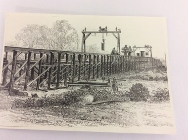
Photograph - Black and white photograph of a drawing, A black and white photograph of a drawing of the construction of the bridge crossing the Murray River at Echuca in 1887, 1981
The drawing shows all the activity and building roles involved in building a bridge in 1877. The crossing of the Murray River was very important to citizens living in both Echua, but especially those living in Moama and in further NSW regions as it provided them with access to Victorian market regions. The bridge was built privately for Deniliquin farmers, but eventually opened up to the general public.This is significant because it represents the roles of different tradesmen in the construction industry in the late 19th Century. It also shows construction stages . Bridge pylons are being inserted into the fiver banks. It is also a very well produced drawing, the artist is anonymous, but very skilled.A photograph of a drawing of the construction of the bridge crossing the Murray River in 1877. The picture shows surveyors, construction workers, crane operators, hoists and a crane and much activity.Written on the back in pen are the numbers 6530. In pencil are the numbers 61/8"? and 10"?. Stamped on the back is a small rectangle with the words 'COPYRIGHT. This photograph may not be reproduced without permission in writing from the Editot of "The Age" 250 Spencer Street Melbourne, and 39/41 York St., Sydney.' written inside it.bridge works, murray river crossing, moama, echuca, orm cook collection, 'the age' newspaper., deniliquin farmers, engineering, bridge building, pylons, 1877 -
 Eltham District Historical Society Inc
Negative - Photograph, J.A. McDonald, Eltham-Yarra Glen Road, Lower Plenty footbridge, Sep. 1955
The Eltham-Yarra Glen Road as designated originated at the Shire of Eltham boundary at the Plenty River. West of the river the road was known as the Heidelberg-Eltham Road. The section from the Plenty River is now known as Lower Plenty Road which becomes Main Road. The footbridge no longer exists but was originally sited to the south, adjacent to the old Lower Plenty Bridge, now part of the Plenty River Trail. Record of various Shire of Eltham infrastructure works undertaken during the period of 1952-1962 involving bridge and road reconstruction projects, sometimes with Eltham Shire Council Project Reference numbers quoted. It was during this period that a number of significant improvements were made to roads and new bridges constructed within the shire that remain in place as of present day (2022). In many situations, the photos provide a tangible visible record of infrastructure that existed throughout the early days of the Shire. The album was put together by or under the direction of the Shire Engineer, J.A. McDonald.1955-09, eltham-yarra glen road, lower plenty footbridge, lower plenty, lower plenty bridge, lower plenty road, main road, plenty river trail, bridge construction, infrastructure, shire of eltham -
 Vision Australia
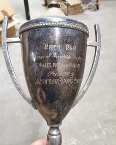
Award - Image, River Run trophy
A metal cup with handles and lid sits on top of a plastic mound. Inscribed on the cup are the words "River Run, Winner of Perpetual Trophy, Health Fitness & Vitality, Presented by Golden Bowl Sports Centre". At the base of the award are listed the names of past winners: 1978 Rob Wallace, 1979 Eric Sigmont, 1980 Rod Pitt, 1981 Robert Gilfillin, 1982 Eric Sigmont, 1983 Max Little, 1984 Dennis Clark, 1985 Michael Hillardt, 1986 Robin Rishworth, 1987 Malcolm Norwood. Image of tarnished metal cup with lid and two handlesRiver Run, Winner of Perpetual Trophy, Health Fitness & Vitality, Presented by Golden Bowl Sports Centreassociation for the blind, awards -
 Greensborough Historical Society
Application, Squatters, speculators and settlers: Plenty River Cultural heritage trail, 20/12/2011
This application is for the restoration and preservation of listed heritage sites along the Plenty River in Greensborough and surrounding area. Although the 2011 application was not successful there is much information about the Plenty River trail in this document.This document contains relevant information regarding the various sites along the Plenty River. 3 copies. 60 p., ill. (some col.). Copy 1 is in an A4 3 ring binder and plastic pockets (Location Greensborough Historical Society publications shelf), copy 2 is spiral bound (Location Plenty River Cultural heritage Trail file), copy 3 has loose pages (Location GHS file)Heritage Victoria application reference: 53149plenty river cultural heritage trail, dennis ward, anne paul, rotary club of greensborough, plenty historical society, plenty river -
 Greensborough Historical Society
Book, Melbourne Water, Plenty River Waterway Management Activity Plan 2000, 2000_
This report covers the catchment of the Plenty River from its upper reaches in the Great Dividing Range to the confluence with the Yarra River at Viewbank. It discusses ecological diversity and methods of improving water quality and significant areas of the catchment. Includes a brief history of settlement along the Plenty River.This is a significant plan for the improvement of the Plenty River.207 p., maps, folding maps. Printed on white paper with black spiral binding and clear plastic front cover.plenty river, melbourne water -
 Wodonga & District Historical Society Inc
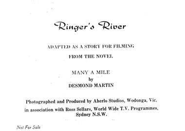
Album - Ringer's River by Des Martin - Cast, Credits & Introduction
Des Martin lived all his life in Wodonga, except for his years of service during World War Two. He was raised on the family property Aherlo in the Huon Creek Valley. In 1937 he joined the 8th Light Horse Regiment but in May 1940 led his Wodonga Troop into the 2/2nd Australian Pioneer Battalion, which saw service in Syria, Java, New Guinea and Borneo. After the war, Des returned to Aherlo and his horses. He was granted permission by the Victorian Racing Club to participate as an amateur “gentleman” rider. He was a founder of the Victorian Amateur Riders Association and also the Murray Valley Hunt Club, for which he was Master for 21 years. He was a prolific writer, cartoonist, photographer and poet, contributing to The Border Morning Mail, The Age, and the Herald and Weekly Times amongst other publications. Des Martin’s other literary works included Australia Astride (1959), A Tale of Twin Cities, Part One (1981) and Backing up the Boys (1998). In 1976, Des wrote an historical novel, “Many a Mile”, based on a fictional region which highly resembled the Albury-Wodonga and Upper Murray area of Victoria. It was set in the last 10 years leading up to Federation. Throughout this period tensions (caused by fluctuating border duties, including an infamous impost on cattle and horses) occasioned the intermittent posting of heavily armed police detachments along the River Murray. Des also wrote eight 50-minute scripts from “Many a Mile” as a television series and were presented to Michael Pate, one of Australia’s leading actors and producers. Also, funding was sought through the Australian Broadcasting Commission ... unfortunately the series never came to fruition. This album is a pictorial precis, including photos and scene descriptions, created to promote the concept of the series and have it produced locally in North Eastern Victoria featuring local settings, skilled horsemen and actors. It was to be called “Ringer’s River” ... Ringer being the title accorded to either a top cattle hand, or the fastest shearer in the wool shed. Des Martin died on 12th April 1995.These albums and images are significant because they document literature written by a prominent member of the Wodonga community. The presentation of this precis was supported by several significant district families and individuals.Documents written to introduce the concept of "Ringer's River" to gain interest for the development of a television seriesdes martin, many a mile, ringer's river, northeast victoria stories -
 Kew Historical Society Inc
Photograph - Yarra Bend and Kew Asylum, 1924
Henry Beater Christian (1886-1962) , was a descendant of one of the earliest settler families in Kew. Employed at the Kew Asylum as a 'public servant', he was a skilled amateur photographer, photographing numerous scenes in Kew and on his travels around Victoria. The majority of his photographs date from 1916 to 1929. His finest photographs are housed in two photograph albums. Digital copy of a photograph from page 6 of the 47-page photograph album containing 261 gelatinous silver images, loaned by Diane Washfold with permission given to digitise and hold a copy in our collection. This is a photograph of the grounds of the Yarra Bend Asylum looking across the Yarra River to the Kew Asylum on the horizon. The photograph predates the 1929 closure of the Yarra Bend Asylum. "Yarra Rvr / Kew"henry beater christian (1886-1962), landscape photography, kew (vic.) — yarra river, christian-washfold collection, photograph albums, yarra bend asylum, kew asylum, yarra bend park -
 Yarra Glen & District Historical Society
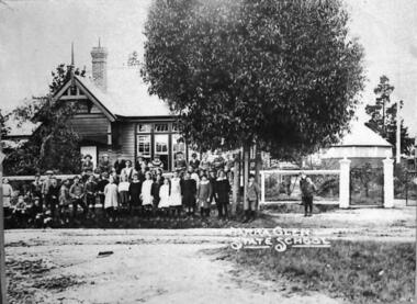
Sepia photographs, Yarra Glen State School c.1915
Photograph of the Yarra Glen State School about 1915. The students are standing in front of the fence. A flagpole, a hand-gate and full-size gate are to the right of the picture. Beyond the gates are two small round shelter sheds with pointed roofs. The school building is in the background to the left of the picture. In the foreground is Symond Street.On the back (cardboard mounting) "State School/Yarra Glen 956/Marj Bull, Elise Tonge/Myra Tonge/Marj Allen/Ritva Hill/Ethel Hill". In another hand "Myra & Heather 12 wks/Dec 1935" which does not seem to be relevant to the photographyarra glen, yarra glen state school, yarra glen primary school, shelter shed, symond street -
 Port Fairy Historical Society Museum and Archives
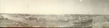
Photograph - Panoramic Photograph, A.C. Aberline, Moyne River East Beach Port Fairy. SS Casino
The steamer S.S.CASINO was much loved by the whole Port Fairy community- with the possible exception of some of the fishermen whose boats she ran down! Transport of the large quantities of wool, potatoes, onions, grain, sheep, cattle and other produce grown on the rich lands of the Western District Belfast was served by a plethora of shipping, both sail and steam, but only one of the steamers then in the regular trade (S.S. DAWN) would ever be able to get up the river and reap the cost savings of loading against a wharf. It was not unusual for four steamers to be anchored in the bay at once and for seven or eight different steamers to call during a week. A number of inter-colonial steamers also called to pick up produce for delivery to Melbourne, Sydney and Adelaide. Production in the Western District was increasing and virtually all of that production had to go through one of the western ports in order to reach markets. By 1882 a meeting 15ft. March, 1882, in the office of auctioneer, J.B. HoIden in Cox Street took action and it was unanimously resolved - that the Belfast & Koroit Steamship Company be formed with a capital of £20,000 in 10,000 shares of £2 each". A number of steamers were offered by letter to the fledgling company, including the new and almost sister ships, CASINO and HELEN NICHOLL. The CASINO was on her delivery voyage from England was due to arrive in Warrnambool to load potatoes for Sydney and, initially, arrangements were made for her to call into Port Fairy for inspection by the BKNS Co directors. She eventually proceeded direct to Warrnambool and the Directors inspected her there. Without hesitation they purchased her even though they had to raise a large bank loan to do so. The CASINO arrived in Port Fairy on Saturday, 29th. July, 1882, steaming triumphantly up the Moyne River, and was greeted by crowds, many of whom had driven in from the surrounding countryside, which gave her “loud ringing English cheers". By 1884 the CASINO could not carry all the cargoes available to her and in December of that year the company purchased the new steamer BELLINGER to provide additional capacity. She helped to open up the intermediate ports of Lorne, Apollo Bay and Port Campbell, but the BELLINGER was not really suitable for the trade and she was sold in 1887, leaving the CASINO to operate alone -as she was to do for almost all of the next 45 years. The opening of the railway in 1890 decreased the cargo available to the steamers and the economic depression of the early 1890's worsened the situation. The weak soon began to fall by the wayside and when the Portland & Belfast SN Co. decided to go into liquidation in April 1895, the Belfast & Koroit Company bought the Portland Company's steamer DAWN on advantageous terms, a substantial part of the payment being in BKSN Co shares. The BKNS Co and the Howard Smith Line came into direct head to head competition and nearly forced the BKNS Co out of existence. Cargo dropped to such an extent that in 1899, they reached agreement that only one ship would run and that the ship which ran would pay a weekly amount to the competitor to stay out of the trade. This controlled service ceased in1909, and competition intensified when Howard Smith placed the newly built, larger steamer EUMERALLA on the run. The BKNS Co survived this competition and even prospered during it partly by extending on a more regular basis, the CASINO'S voyages to South Australian ports Port Macdonnell, Kingston, Beachport, Robe and, on occasions Adelaide. There were setbacks when, on 20 October 1924, CASINO went ashore at the Kennett River, near Apollo Bay, and again, in February l929, when she struck a submerged object at Warrnambool and had to be beached. The railways placed great competitive pressure on the small steamship company and this pressure was intensified when the Great Depression slashed the market for Western District produce, BKNS Co struggled on, paying dividends in most years, and the company planned a big celebration for the CASINO'S fiftieth anniversary in the trade on 29th July, 1932. Disaster struck soon after 9 o'clock on the morning of Sunday I0 July, 1932 when the CASINO was lost at Apollo Bay together with the lives of 10 crew members. black and white panaramic photograph mounted on cardboardMoyne River & East Beach Port Fairy- s.s.Casino-A.C.Aberline-Canterburyship, boat, sea, river, training walls, wharf, moyne river, s.s.casino, steamer -
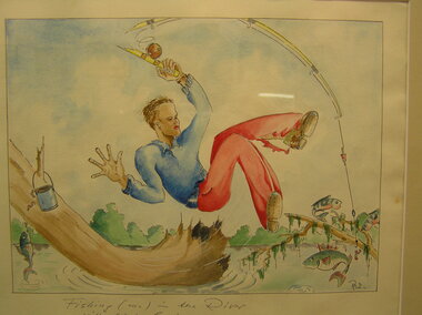 Tatura Irrigation & Wartime Camps Museum
Sketch - Watercolour, Georg Rosenkranz, Fishing in the River, 1941/2
Artist Georg Rosenkranz, crewman aboard the HSK Kormoran, painted this while at Graytown Prisoner of War Camp.Watercolour sketch of a man in blue shirt and red trousers with fishing rodFishing in the river with Lieutenant Gardenergraytown pow camp, georg rosenkranz, illustrations, watercolour -
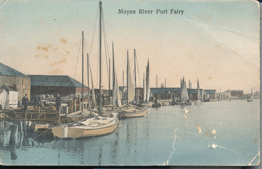 Port Fairy Historical Society Museum and Archives
Postcard - Photograph, A.C. Aberline, Fishing boats in Mayne River
Shows the fishing fleet in the harbour this postcard was used to send a message home to family and friends regarding their stay in Port FairyA photograph of a busy fishing town and tourist mecaHand coloured photograph/postcardMoyne River Port Fairyharbour, fishing fleet -
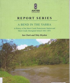 Greensborough Historical Society
Book, Ian D. Clark et al, A Bend in the Yarra: a history of the Merri Creek protectorate Station and Merri Creek Aboriginal School 1841-1851, by Ian D. Clark and Toby Heydon, 2004_
A history of Aboriginal cultural institutions in colonial Victoria, in this book the interaction between Wurundjeri people and government officials and settlers at the confluence of the Merri Creek and Yarra River.Paperback book, 90 p. black & white illusmerri creek, aborigines victoria -
 Ringwood and District Historical Society
Photograph, Opening Yarra Valley (undated)
Written on backing sheet, "Opening Yarra Valley" -
 Alfred Health (The Alfred, Caulfield Hospital, and Sandringham Hospital)
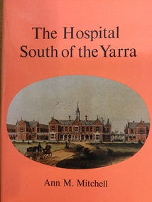
Book, Ann M Mitchell, The Hospital South of the Yarra A history of Alfred Hospital Melbourne from foundation to the nineteen-forties, 1977 The Griffin Press
Board of Management of The Alfred commissioned Ann M Mitchell to write a history of the hospital from its foundation until the nineteen-forties. The hospital treated its first outpatient on 6 March 1871 and its first inpatient on 13 March 1871.Book details major milestones of hospital's history from 1860's including its naming after Prince Alfred. Records major achievements including important treatment, teaching and research. Lists many important personnel including doctors, nurses, matrons and Board Members.Small Book 299 Pages Red CoverThe Hospital South of the Yarra, Ann M Mitchellthe alfred, history, 1871, 1940's, medical, patients, health, hospital -
 Wonga Park Community Cottage History Group
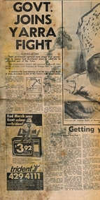
Newspaper (Item) - Cutting, Wonga Park: Herald newspaper cutting 16/9/1972 Govt Joins Yarra Fight
State Government agencies have joined local government to oppose lan developers' plans to subdivide an untouched pat of the Yarra. The subdivision involves 565 hectares (Yarra Brae and Stane Brae) and more than 16 kms of bush river frontage at Wonga Park in Lillydale Shire -
 Lakes Entrance Regional Historical Society (operating as Lakes Entrance History Centre & Museum)
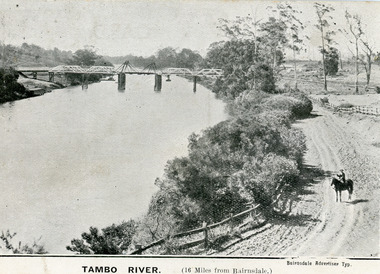
Postcard, 1906
First timber road bridge over the Tambo River at Swan Reach officially opened 20 December 1905, after which punt was removed to BairnsdaleBlack and white postcard of the lifting bridge over the Tambo River at Swan Reach, Victoria. Man on horse standing on dirt road to Metung beside the river. Punt previously used to cross river visible against western bank of river.Tambo River (16 miles from Bairnsdale)bridges, waterways -
 Marysville & District Historical Society
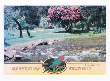
Postcard (item) - Colour postcard, Neil Cutts, Marysville Victoria-Steavenson River, Pre 2009
A postcard in a series produced by the Rose Stereograph Company in Victoria, Australia as a souvenir of Marysville.A colour photograph of the Steavenson River which flows through Marysville in Victoria. The Rose Series postcard No. 3527.POST CARD The "Rose" Series/ De Luxe Proudly Printed in/ Australia Since 1880 AFFIX/ STAMP/ HERE/ Rose Series/ Post Card No./ 3527 ADDRESS/ Nancy Oliver/ 14/150 Tyabb Road/ Mornington/ Victoria - 3931/ POSTCODE Steavenson River/ MARYSVILLE, VICTORIA, AUSTRALIA/ Photo Neil Cutts Copyright Rose Stereograph Co., Glen Waverley, Victoria (03) 9560 7772 8-3-2003 Dear Nancy/ here we are/ at Mary Lyn./ Everything is about the name nice/ pleasant & cheerful & restful meeting different people/ every day but we miss dear Nancy & Company eh?/ We did not notice any changes the prices are up./ We enjoy walking most mornings Eric enjoys/ longer walks in the afternoon. The weather so far/ has been nice cool and/ pleasant and time is passing/ quickly Hope to meet you in/ Nov. all being well./ Love Sarina & Ericmarysville, victoria, steavenson river, postcard, souvenir, rose stereograph co, 3527 -
 Eltham District Historical Society Inc
Negative - Photograph, J.A. McDonald, Eltham-Yarra Glen Road, Lower Plenty footbridge, Sep. 1955
Tony Carberry and J. Jolly The Eltham-Yarra Glen Road as designated originated at the Shire of Eltham boundary at the Plenty River. West of the river the road was known as the Heidelberg-Eltham Road. The section from the Plenty River is now known as Lower Plenty Road which becomes Main Road. The footbridge no longer exists but was originally sited to the south, adjacent to the old Lower Plenty Bridge, now part of the Plenty River Trail. Record of various Shire of Eltham infrastructure works undertaken during the period of 1952-1962 involving bridge and road reconstruction projects, sometimes with Eltham Shire Council Project Reference numbers quoted. It was during this period that a number of significant improvements were made to roads and new bridges constructed within the shire that remain in place as of present day (2022). In many situations, the photos provide a tangible visible record of infrastructure that existed throughout the early days of the Shire. The album was put together by or under the direction of the Shire Engineer, J.A. McDonald.1955-09, eltham-yarra glen road, lower plenty footbridge, j. jolly, lower plenty, lower plenty bridge, lower plenty road, main road, plenty river trail, tony carberry, bridge construction, infrastructure, shire of eltham -
 Greensborough Historical Society
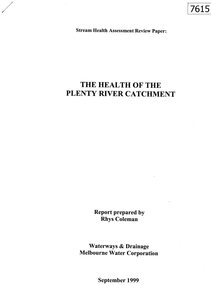
Document - Report, Rhys Coleman, The Health of the Plenty River Catchment 1999, 1999_09
Report prepared by Rhys Coleman for Waterways and Drainage, Melbourne Water Corporation, discusses the health of the Plenty River catchment from upstream of Toorourrong Reservoir, through Whittlesea and Mernda, South Morang and Plenty to Greensborough and confluence with the Yarra River.31 p., tables.plenty river, melbourne water corporation -
 Upper Yarra Museum
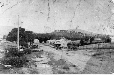
Negative Photographic Reproduction, Main St Yarra Junction
03042 Main street opposite the railway station, 1909, Yarra Junction. Upper Yarra Shire 1888-1988 Centenary collection. Black & white Negative, scanned at 600 dpiearly main street yarra junction -
 Ringwood and District Historical Society
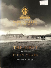
Book, Yarra Valley Grammar School - The First 50 Years - 1966-2015
History of Yarra Valley Grammar School, Kalinda Road, Ringwood. -
Ringwood and District Historical Society
Envelope, Packet: Information re opening of Upper Yarra Reservoir and information re Yan Yean Reservoir
Correspondence; Souvenir of opening of Upper Yarra Reservoir; Historical surveys -
 Orbost & District Historical Society
newspaper clippings
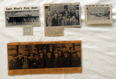
This collection of articles was collated by Mary Gilbert. 743.1 - In the group are, from left to right:—First Row—Councillors T. W. Murphy (Bairnsdale), J. R. Coate (Lakes Entrance); T. Hodgd (Tambo), W. Wilson (Berwick), A. Inglis (Mirboo), E. S. Whittakers (Traralgon), and W. C. Kingston (Warragul). Second Row—J. S. Lister (Rosedale), R. Stockdale (Narracan), W. Grose (Omeo), and J. Allan (Toora). Back Row—S. Purdy (Maffra), E. Heesom (Morwell), J. Arohibald (Bruthen), Mr. Lind, M.L.A., Councillor A. E. Rodwell (Orbost), Mr. S. Langslow (Health department), and Mr. C. S. Ogllvy (Warragul). A manila folder of newspaper cuttings related to commerce and government in Orbost. 743.1 is titled, " Gippsland Councillors Wait on State Ministers and is from The Argus, July 1926 .It has a large black / white photograph of the representatives of shires and boroughs of Gippsland who formed a deputation to meet which waited most of the State Ministers with various requests. 743.4 is from the Snowy River Mail and is titled, "Cann RIver's first Hotel" and has a black and white photograph of a four-wheeled buggy pulled by four horses standing outside a hotel. 743.5 is titled "At the End of a Long Trip" and is from the Snowy River Mai. It has a black and white photograph of the Cann River hotel with Mr W. Dreverman standing outside. 743.6 is from the Snowy River Mail, September 6, 1967, and is titled, " Orbosr Businessmen 20 Years Ago" and has a black and white photograph of a group of men in business suits.orbost-business cann-river-hotel -
 Greensborough Historical Society
Map, Melbourne and Metropolitan Board of Works. Survey Division, MMBW, Yarra 2500 / 13.24. Plenty, Memorial Drive, 1979_03
Melbourne and Metropolitan Board of Works. Yarra 2500 [base map] 13-24. Plenty, Memorial Drive. Parish of Morang 3183. Municipalities of Diamond Valley 257 and Whittlesea 239. Prominent streets include: Oatland Road, River Avenue and Memorial Drive. Includes Plenty River and SEC Transmission easement.MMBW Map in 1:2500 [scale] series. Cream parchment with green tape reinforcing on edges and punched holes on left edge.mmbw, melbourne and metropolitan board of works, shire of diamond valley, plenty - maps