Showing 6813 items
matching 1956-01
-
 Ballarat Heritage Services
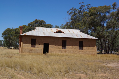
Photograph, Former Kurting Mechanics' Institute, Victoria, 2016, 10/01/2016
Kurting. Mechanics' Hall OFFICIAL OPENING. SUCCESSFUL FUNCTION. Favored by beautiful weather, the official opening ot the new Mechanics' Hall erected at Kurting proved an entire success. There was a large attendance ol local and district residents, and a sports meeting held during the afternoon in aid of Red Cross funds resulted in a substantial amount being netted. The hall, which stands on ground generously donated by Mr J. Hogan, between the school and the creek, is a substantialyvconcrete building of pleasing design, and was erected at a cost of about £330 by Mr J. H. Secombe, who also materially assisted the committee in the matter of finance. It is 48ft. long by 24ft. wide, with 12ft, walls, and should prove equal to the needs of the district for many years to come. It is well ventilated, and has large windows, these opening outwards on hinges. Doors at each side, and the back, as well as in front, give free means of access, while a fireplace in the back allows of provision being made for supper arrangements, water being laid on from a tank. Provi sion has been made for the partitioning off ot portion of the hall at any time this may be considered desirable. To provide a stage eight tables of a uniform size have been constructed to fit across the width of the hall. By these it will be possible, when euchre parties are being held, to use the full length of the hall. ... (Inglewod Advertiser, 19 July 1918) and also to convert tiie "stage" into card tables. The committee still has work ahead in the provision of a ceiling for the building and seating accomodation, but there is no doubt that the public support accorded them will be sufficient to enable these matters to be dealt with in the near future. A fine floor has been put down.Photographs of the former Kurting Hall, Victoria.kurting, kurting hall, john hogan, kurting mechanics' institute -
 Ballarat Heritage Services
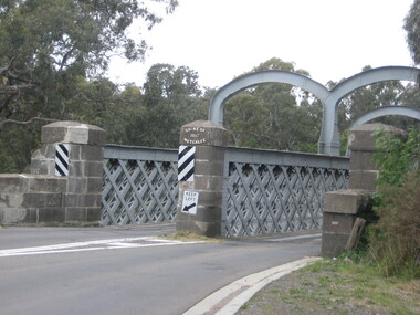
Photograph, Redesdale Bridge, 2016, 18/01/2016
The Redesdale Bridge is a wrought iron and timber structure with bluestone abutments which was installed over the Campaspe River in January 1868, although the bridge actually bears the date 1867. In 1859, the "Herald of the Morning", a ship carrying a cargo including 350 tons of ironwork for the Hawthorn bridge, caught fire and was scuttled a quarter of a mile off the jetty at Sandridge. A Melbourne salvaging firm raised the ironwork from the bottom of the bay, but after details of an arranged sale to the government caused a scandal in Parliament, the material was sold privately to the Melbourne foundry Langlands & Co. Two hundred tons of it was sold to the goldfields shires of McIvor and Metcalfe for only £1000. The bridge was designed by engineer T.B. Muntz and built by a contractor named Doran, and was completed late and considerably over budget at £6274. The bridge spans 45.7m across the river and has two roadways which are carried between three metal lattice girders in a through truss configuration. The design for the Hawthorn bridge had the deck supported over the trusses, and to stiffen the through truss configuration three sets of distinctive paired arches connect the trusses above the roadways. The roadway decking is constructed of longitudinally placed timbers on timber cross girders which rest on the lower chords of the trusses. (Heritage Victoria) A number of colour photographs showing the historic bridge at Metcalfe.metcalfe, shire of metcalfe, bridge, municipal boundary, shire of mcivor, redesdale bridge, campaspe river, t.b. muntz, doran -
 Ballarat Heritage Services
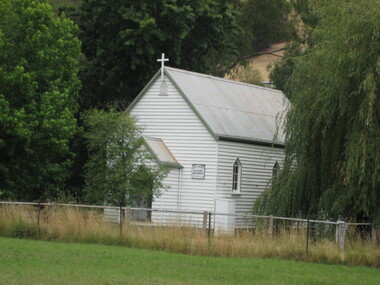
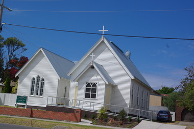
Photograph - Church, Clare Gervasoni, Molesworth Anglican Church, Victoria, 2016, 18/01/2016
Colour photograph of the weatherboard Molesworth Hall. molesworth anglican church, molesworth -
 Ballarat Heritage Services
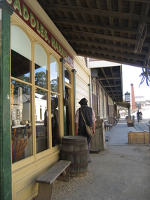
Photograph - Colour, Sovereign Hill, 2008, 01/02/2008
Colour photograph of the Main Street of Sovereign Hill.sovereign hill -
 Ballarat Heritage Services
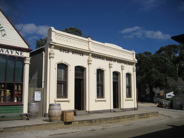
Photograph - Colour, Sovereign Hill Colonial Bank and Gold Office, 2008, 01/02/2008
Colour photograph of the Main Street of Sovereign Hill.sovereign hill -
 Ballarat Heritage Services
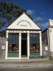
Photograph - Photograph - Colour, Sovereign Hill's Wayne and Robinson Apothecary, 2008, 01/02/2008
Colour photograph of the Main Street of Sovereign Hill featuring Sovereign Hill's Wayne and Robinson Apothecary.sovereign hill, apothecary, wayne and robinson -
 Ballarat Heritage Services
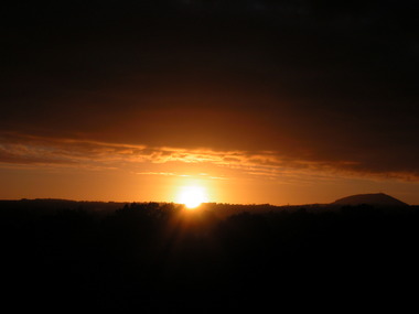
Photograph - Colour, Clare Gervasoni, Sunset over Ballarat East (looking towards Mt Warrenheip), 2008, 01/04/2008
ballarat east, sunset, mount warrenheip, armstrong street south -
 Ballarat Heritage Services
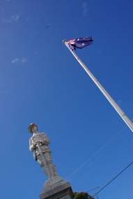
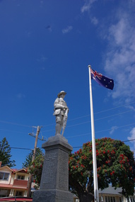
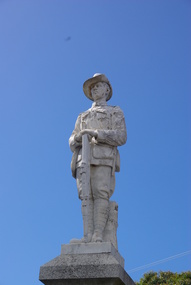
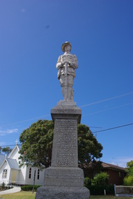
Photograph - Colour, Clare Gervasoni, Apollo Bay War Memorial, 27/01/2013
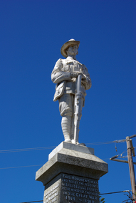
This memorial was erected by the residents of Apollo Bay and District in 1922.Colour photograph of the War Memorial at Apollo Bay, that features a scuplture of an Australian soldier with slouch hat and holding a rifle. It includes a list of those who served during World War One and World War Two. A characteristic figurative monument, the memorial comprises a single standing soldier, looking down the main street, a top a polished granite pedestal with honour roll set on a huge rock faced granite block.The memorial is fenced by heavy set square concrete bollards supporting heavy gauge chain between each. tBuilt by J. Wilson & Co. of Bendigo, the Apollo Bay Memorial depicts the lone soldier, a typical symbol of the sentiments of communities who had lost faith in heroism and had learnt to recognise the level of loss caused by war amongst ordinary volunteers. This recognition,which occurred throughout Australia, marked a turning point as the 'unknown soldier' was increasingly commemorated instead of military leaders as had previously been the traditional practice. apollo bay war memorial, australian soldier memorial, cawood, mitchell, finlayson, marriner, maguire, mclennan, stephens, vipont, lang, turner, thomson, h.f. smith, a.e. hunt, ormsby, elston, gooday, p. bird, costin, de vere, de forest, j. bowie, c. hughes, r. irving, mcminn, newman, riley, sculley, townsend, thornton, thurst, wright, j. wilson, stonemason -
 Ballarat Heritage Services
Photograph - Colour, Clare Gervasoni, Apollo Bay War Memorial, 26/01/2016
This memorial was erected by the residents of Apollo Bay and District in 1922.Colour photograph of the War Memorial at Apollo Bay, that features a scuplture of an Australian soldier with slouch hat and holding a rifle. It includes a list of those who served during World War One and World War Two. A characteristic figurative monument, the memorial comprises a single standing soldier, looking down the main street, a top a polished granite pedestal with honour roll set on a huge rock faced granite block.The memorial is fenced by heavy set square concrete bollards supporting heavy gauge chain between each. tBuilt by J. Wilson & Co. of Bendigo, the Apollo Bay Memorial depicts the lone soldier, a typical symbol of the sentiments of communities who had lost faith in heroism and had learnt to recognise the level of loss caused by war amongst ordinary volunteers. This recognition,which occurred throughout Australia, marked a turning point as the 'unknown soldier' was increasingly commemorated instead of military leaders as had previously been the traditional practice. apollo bay war memorial, australian soldier memorial, cawood, mitchell, finlayson, marriner, maguire, mclennan, stephens, vipont, lang, turner, thomson, h.f. smith, a.e. hunt, ormsby, elston, gooday, p. bird, costin, de vere, de forest, j. bowie, c. hughes, r. irving, mcminn, newman, riley, sculley, townsend, thornton, thurst, wright, j. wilson, stonemason -
 Ballarat Heritage Services
Photograph - Colour, Clare Gervasoni, Apollo Bay War Memorial, 27/01/2013
This memorial was erected by the residents of Apollo Bay and District in 1922.Colour photograph of the War Memorial at Apollo Bay, that features a scuplture of an Australian soldier with slouch hat and holding a rifle. It includes a list of those who served during World War One and World War Two. A characteristic figurative monument, the memorial comprises a single standing soldier, looking down the main street, a top a polished granite pedestal with honour roll set on a huge rock faced granite block.The memorial is fenced by heavy set square concrete bollards supporting heavy gauge chain between each. tBuilt by J. Wilson & Co. of Bendigo, the Apollo Bay Memorial depicts the lone soldier, a typical symbol of the sentiments of communities who had lost faith in heroism and had learnt to recognise the level of loss caused by war amongst ordinary volunteers. This recognition,which occurred throughout Australia, marked a turning point as the 'unknown soldier' was increasingly commemorated instead of military leaders as had previously been the traditional practice. apollo bay war memorial, australian soldier memorial, cawood, mitchell, finlayson, marriner, maguire, mclennan, stephens, vipont, lang, turner, thomson, h.f. smith, a.e. hunt, ormsby, elston, gooday, p. bird, costin, de vere, de forest, j. bowie, c. hughes, r. irving, mcminn, newman, riley, sculley, townsend, thornton, thurst, wright, j. wilson, stonemason -
 Ballarat Heritage Services
Photograph - Colour photograph, Clare Gervasoni, Apollo Bay War Memorial, 27/01/2013
This memorial was erected by the residents of Apollo Bay and District in 1922.Colour photograph of the War Memorial at Apollo Bay, that features a scuplture of an Australian soldier with slouch hat and holding a rifle. It includes a list of those who served during World War One and World War Two. A characteristic figurative monument, the memorial comprises a single standing soldier, looking down the main street, a top a polished granite pedestal with honour roll set on a huge rock faced granite block.The memorial is fenced by heavy set square concrete bollards supporting heavy gauge chain between each. Built by J. Wilson & Co. of Bendigo, the Apollo Bay Memorial depicts the lone soldier, a typical symbol of the sentiments of communities who had lost faith in heroism and had learnt to recognise the level of loss caused by war amongst ordinary volunteers. This recognition,which occurred throughout Australia, marked a turning point as the 'unknown soldier' was increasingly commemorated instead of military leaders as had previously been the traditional practice. apollo bay war memorial, australian soldier memorial, cawood, mitchell, finlayson, marriner, maguire, mclennan, stephens, vipont, lang, turner, thomson, h.f. smith, a.e. hunt, ormsby, elston, gooday, p. bird, costin, de vere, de forest, j. bowie, c. hughes, r. irving, mcminn, newman, riley, sculley, townsend, thornton, thurst, wright, j. wilson, stonemason -
 Ballarat Heritage Services
Photograph - Colour, Clare Gervasoni, Apollo Bay War Memorial, 2013, 26/01/2013
This memorial was erected by the residents of Apollo Bay and District in 1922.Colour photograph of the War Memorial at Apollo Bay, that features a scuplture of an Australian soldier with slouch hat and holding a rifle. It includes a list of those who served during World War One and World War Two. A characteristic figurative monument, the memorial comprises a single standing soldier, looking down the main street, a top a polished granite pedestal with honour roll set on a huge rock faced granite block.The memorial is fenced by heavy set square concrete bollards supporting heavy gauge chain between each. tBuilt by J. Wilson & Co. of Bendigo, the Apollo Bay Memorial depicts the lone soldier, a typical symbol of the sentiments of communities who had lost faith in heroism and had learnt to recognise the level of loss caused by war amongst ordinary volunteers. This recognition,which occurred throughout Australia, marked a turning point as the 'unknown soldier' was increasingly commemorated instead of military leaders as had previously been the traditional practice. apollo bay war memorial, australian soldier memorial, cawood, mitchell, finlayson, marriner, maguire, mclennan, stephens, vipont, lang, turner, thomson, h.f. smith, a.e. hunt, ormsby, elston, gooday, p. bird, costin, de vere, de forest, j. bowie, c. hughes, r. irving, mcminn, newman, riley, sculley, townsend, thornton, thurst, wright, j. wilson, stonemason -
 Ballarat Heritage Services
Photograph - Photograph - Colour, Clare Gervasoni, St Aiden's Anglican Church, Apollo Bay, 2013, 27/01/2013
Colour photograph of weatherboard church at Apollo Bay. Gothic in style it is typical of the simple timber churches built by less wealthy communities in Victoria, mostly before the First World War. St Aiden's was built and opened in 1905, with a local resident as builder. .St Aidan's is one of only a few buildings in Apollo Bay remaining from before World War I. apollo bay, st aiden's anglican church -
 Ballarat Heritage Services
Photograph - Colour, Toilets, Old Sarum, England, English Heritage Site, 2016, 01 November 2016
William the Conqueror inherited Old Sarum from the last Saxon king of England. It was an ideal site for a royal castle. It was here in 1070 that William paid off his army after a long and bitter campaign in northern England. It was here in 1086 that he called together all the major landholders in England so they could swear allegiance to him. It was a crucial moment. The Domesday Book was being written, a threatened Viking invasion had only just been averted and William's eldest son was in armed rebellion. Old Sarum was an important place where this Norman king of England held power. In 1794 the Ordnance Survey set out to check the accuracy of the first mapping of Southern England, which had begun ten years earlier. From a point just below Old Sarum Lieutenant William Mudge laid out a base-line 36,574 feet (11,253 metres) long. From each end of the line the positions of distant places were plotted using a huge theodolite made in 1791 by Jesse Ramsden. The accuracy of the process, which was repeated all over England, depended on Jesse Ramsden's craftsmanship and on William Mudge's surveying skill in setting out this first base-line from Old Sarum. The nearer end of Mudge's line is marked by an inscribed stone beside the modern A345 at Old Sarum. ordnance survey, william mudge, jesse ramsden, william the conqueror, old sarum, saxon, 1086, england -
 Ballarat Heritage Services
Photograph - Colour, Stonework, Old Sarum, England, English Heritage Site, 2016, 01 November 2016
William the Conqueror inherited Old Sarum from the last Saxon king of England. It was an ideal site for a royal castle. It was here in 1070 that William paid off his army after a long and bitter campaign in northern England. It was here in 1086 that he called together all the major landholders in England so they could swear allegiance to him. It was a crucial moment. The Domesday Book was being written, a threatened Viking invasion had only just been averted and William's eldest son was in armed rebellion. Old Sarum was an important place where this Norman king of England held power. In 1794 the Ordnance Survey set out to check the accuracy of the first mapping of Southern England, which had begun ten years earlier. From a point just below Old Sarum Lieutenant William Mudge laid out a base-line 36,574 feet (11,253 metres) long. From each end of the line the positions of distant places were plotted using a huge theodolite made in 1791 by Jesse Ramsden. The accuracy of the process, which was repeated all over England, depended on Jesse Ramsden's craftsmanship and on William Mudge's surveying skill in setting out this first base-line from Old Sarum. The nearer end of Mudge's line is marked by an inscribed stone beside the modern A345 at Old Sarum. ordnance survey, william mudge, jesse ramsden, william the conqueror, old sarum, saxon, 1086, england -
 Ballarat Heritage Services
Photograph - Colour, looking from Stonework towards earth mounds, Old Sarum, England, English Heritage Site, 2016, 01 November 2016
William the Conqueror inherited Old Sarum from the last Saxon king of England. It was an ideal site for a royal castle. It was here in 1070 that William paid off his army after a long and bitter campaign in northern England. It was here in 1086 that he called together all the major landholders in England so they could swear allegiance to him. It was a crucial moment. The Domesday Book was being written, a threatened Viking invasion had only just been averted and William's eldest son was in armed rebellion. Old Sarum was an important place where this Norman king of England held power. In 1794 the Ordnance Survey set out to check the accuracy of the first mapping of Southern England, which had begun ten years earlier. From a point just below Old Sarum Lieutenant William Mudge laid out a base-line 36,574 feet (11,253 metres) long. From each end of the line the positions of distant places were plotted using a huge theodolite made in 1791 by Jesse Ramsden. The accuracy of the process, which was repeated all over England, depended on Jesse Ramsden's craftsmanship and on William Mudge's surveying skill in setting out this first base-line from Old Sarum. The nearer end of Mudge's line is marked by an inscribed stone beside the modern A345 at Old Sarum. ordnance survey, william mudge, jesse ramsden, william the conqueror, old sarum, saxon, 1086, england -
 Ballarat Heritage Services
Photograph - Colour, Looking from Stonework towards people walking on earth mounds, Old Sarum, England, English Heritage Site, 2016, 01 November 2016
William the Conqueror inherited Old Sarum from the last Saxon king of England. It was an ideal site for a royal castle. It was here in 1070 that William paid off his army after a long and bitter campaign in northern England. It was here in 1086 that he called together all the major landholders in England so they could swear allegiance to him. It was a crucial moment. The Domesday Book was being written, a threatened Viking invasion had only just been averted and William's eldest son was in armed rebellion. Old Sarum was an important place where this Norman king of England held power. In 1794 the Ordnance Survey set out to check the accuracy of the first mapping of Southern England, which had begun ten years earlier. From a point just below Old Sarum Lieutenant William Mudge laid out a base-line 36,574 feet (11,253 metres) long. From each end of the line the positions of distant places were plotted using a huge theodolite made in 1791 by Jesse Ramsden. The accuracy of the process, which was repeated all over England, depended on Jesse Ramsden's craftsmanship and on William Mudge's surveying skill in setting out this first base-line from Old Sarum. The nearer end of Mudge's line is marked by an inscribed stone beside the modern A345 at Old Sarum. ordnance survey, william mudge, jesse ramsden, william the conqueror, old sarum, saxon, 1086, england -
 Ballarat Heritage Services
Photograph - Colour, Stairs, Old Sarum, England, English Heritage Site, 2016, 01 November 2016
William the Conqueror inherited Old Sarum from the last Saxon king of England. It was an ideal site for a royal castle. It was here in 1070 that William paid off his army after a long and bitter campaign in northern England. It was here in 1086 that he called together all the major landholders in England so they could swear allegiance to him. It was a crucial moment. The Domesday Book was being written, a threatened Viking invasion had only just been averted and William's eldest son was in armed rebellion. Old Sarum was an important place where this Norman king of England held power. In 1794 the Ordnance Survey set out to check the accuracy of the first mapping of Southern England, which had begun ten years earlier. From a point just below Old Sarum Lieutenant William Mudge laid out a base-line 36,574 feet (11,253 metres) long. From each end of the line the positions of distant places were plotted using a huge theodolite made in 1791 by Jesse Ramsden. The accuracy of the process, which was repeated all over England, depended on Jesse Ramsden's craftsmanship and on William Mudge's surveying skill in setting out this first base-line from Old Sarum. The nearer end of Mudge's line is marked by an inscribed stone beside the modern A345 at Old Sarum. ordnance survey, william mudge, jesse ramsden, william the conqueror, old sarum, saxon, 1086, england -
 Ballarat Heritage Services
Photograph - Colour, Public toilets hidden in earth mound, Old Sarum, England, English Heritage Site, 2016, 01 November 2016
William the Conqueror inherited Old Sarum from the last Saxon king of England. It was an ideal site for a royal castle. It was here in 1070 that William paid off his army after a long and bitter campaign in northern England. It was here in 1086 that he called together all the major landholders in England so they could swear allegiance to him. It was a crucial moment. The Domesday Book was being written, a threatened Viking invasion had only just been averted and William's eldest son was in armed rebellion. Old Sarum was an important place where this Norman king of England held power. In 1794 the Ordnance Survey set out to check the accuracy of the first mapping of Southern England, which had begun ten years earlier. From a point just below Old Sarum Lieutenant William Mudge laid out a base-line 36,574 feet (11,253 metres) long. From each end of the line the positions of distant places were plotted using a huge theodolite made in 1791 by Jesse Ramsden. The accuracy of the process, which was repeated all over England, depended on Jesse Ramsden's craftsmanship and on William Mudge's surveying skill in setting out this first base-line from Old Sarum. The nearer end of Mudge's line is marked by an inscribed stone beside the modern A345 at Old Sarum. ordnance survey, william mudge, jesse ramsden, william the conqueror, old sarum, saxon, 1086, england -
 Ballarat Heritage Services
Photograph - Colour, Entrance to Public toilets hidden in earth mound, Old Sarum, England, English Heritage Site, 2016, 01 November 2016
William the Conqueror inherited Old Sarum from the last Saxon king of England. It was an ideal site for a royal castle. It was here in 1070 that William paid off his army after a long and bitter campaign in northern England. It was here in 1086 that he called together all the major landholders in England so they could swear allegiance to him. It was a crucial moment. The Domesday Book was being written, a threatened Viking invasion had only just been averted and William's eldest son was in armed rebellion. Old Sarum was an important place where this Norman king of England held power. In 1794 the Ordnance Survey set out to check the accuracy of the first mapping of Southern England, which had begun ten years earlier. From a point just below Old Sarum Lieutenant William Mudge laid out a base-line 36,574 feet (11,253 metres) long. From each end of the line the positions of distant places were plotted using a huge theodolite made in 1791 by Jesse Ramsden. The accuracy of the process, which was repeated all over England, depended on Jesse Ramsden's craftsmanship and on William Mudge's surveying skill in setting out this first base-line from Old Sarum. The nearer end of Mudge's line is marked by an inscribed stone beside the modern A345 at Old Sarum. ordnance survey, william mudge, jesse ramsden, william the conqueror, old sarum, saxon, 1086, england -
 Ballarat Heritage Services
Photograph - Colour, Masons' Marks, Old Sarum, England, English Heritage Site, 2016, 01 November 2016
William the Conqueror inherited Old Sarum from the last Saxon king of England. It was an ideal site for a royal castle. It was here in 1070 that William paid off his army after a long and bitter campaign in northern England. It was here in 1086 that he called together all the major landholders in England so they could swear allegiance to him. It was a crucial moment. The Domesday Book was being written, a threatened Viking invasion had only just been averted and William's eldest son was in armed rebellion. Old Sarum was an important place where this Norman king of England held power. In 1794 the Ordnance Survey set out to check the accuracy of the first mapping of Southern England, which had begun ten years earlier. From a point just below Old Sarum Lieutenant William Mudge laid out a base-line 36,574 feet (11,253 metres) long. From each end of the line the positions of distant places were plotted using a huge theodolite made in 1791 by Jesse Ramsden. The accuracy of the process, which was repeated all over England, depended on Jesse Ramsden's craftsmanship and on William Mudge's surveying skill in setting out this first base-line from Old Sarum. The nearer end of Mudge's line is marked by an inscribed stone beside the modern A345 at Old Sarum. ordnance survey, william mudge, jesse ramsden, william the conqueror, old sarum, saxon, 1086, england -
 Ballarat Heritage Services
Photograph - Colour, Masons' Marks, Old Sarum, England, English Heritage Site, 01 November 2016
William the Conqueror inherited Old Sarum from the last Saxon king of England. It was an ideal site for a royal castle. It was here in 1070 that William paid off his army after a long and bitter campaign in northern England. It was here in 1086 that he called together all the major landholders in England so they could swear allegiance to him. It was a crucial moment. The Domesday Book was being written, a threatened Viking invasion had only just been averted and William's eldest son was in armed rebellion. Old Sarum was an important place where this Norman king of England held power. In 1794 the Ordnance Survey set out to check the accuracy of the first mapping of Southern England, which had begun ten years earlier. From a point just below Old Sarum Lieutenant William Mudge laid out a base-line 36,574 feet (11,253 metres) long. From each end of the line the positions of distant places were plotted using a huge theodolite made in 1791 by Jesse Ramsden. The accuracy of the process, which was repeated all over England, depended on Jesse Ramsden's craftsmanship and on William Mudge's surveying skill in setting out this first base-line from Old Sarum. The nearer end of Mudge's line is marked by an inscribed stone beside the modern A345 at Old Sarum. ordnance survey, william mudge, jesse ramsden, william the conqueror, old sarum, saxon, 1086, england -
 Ballarat Heritage Services
Photograph - Colour, Masons' Marks, Old Sarum, England, English Heritage Site, 2016, 01 November 2016
William the Conqueror inherited Old Sarum from the last Saxon king of England. It was an ideal site for a royal castle. It was here in 1070 that William paid off his army after a long and bitter campaign in northern England. It was here in 1086 that he called together all the major landholders in England so they could swear allegiance to him. It was a crucial moment. The Domesday Book was being written, a threatened Viking invasion had only just been averted and William's eldest son was in armed rebellion. Old Sarum was an important place where this Norman king of England held power. In 1794 the Ordnance Survey set out to check the accuracy of the first mapping of Southern England, which had begun ten years earlier. From a point just below Old Sarum Lieutenant William Mudge laid out a base-line 36,574 feet (11,253 metres) long. From each end of the line the positions of distant places were plotted using a huge theodolite made in 1791 by Jesse Ramsden. The accuracy of the process, which was repeated all over England, depended on Jesse Ramsden's craftsmanship and on William Mudge's surveying skill in setting out this first base-line from Old Sarum. The nearer end of Mudge's line is marked by an inscribed stone beside the modern A345 at Old Sarum. ordnance survey, william mudge, jesse ramsden, william the conqueror, old sarum, saxon, 1086, england -
 Ballarat Heritage Services
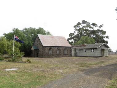
Photograph - Colour, Cressy Church, 2016, 26/01/2016
cressy -
 Ballarat Heritage Services
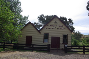
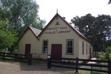
Photograph - Colour, Clare Gervasoni, Fawcett Hall and Public Library, 2015, 11/01//2015
Colour photograph of a weatherboard Hall.fawcett hall and public library, fawcett -
 Ballarat Heritage Services
Photograph - Colour, Clare Gervasoni, Fawcett Hall and Public Library, 2015, 11/01//2015
Colour photograph of a weatherboard Hall.fawcett hall and public library, fawcett, fawcett mechanics' institute -
 Ballarat Heritage Services
Photograph - Colour, Clare Gervasoni, Fawcett Hall and Public Library, 2015, 11/01//2015
Fawcett Hall is 14 kilometres North West of Alexandra, North East Victoria, in Spring Creek Road and is set amongst a small picturesque rural farming and business community with hills as a backdrop and Stony Creek running alongside the public reserves property boundary. Part of our hall building dates back to its establishment in 1882. Originally the hall served as a Mechanics Institute and Public Library and later as a primary school.Colour photograph of a weatherboard Hall.fawcett hall and public library, fawcett, fawcett mechanics' institute