Showing 7209 items
matching 1983
-
 Bendigo Historical Society Inc.
Document - MERLE HALL COLLECTION: VARIOUS NOTICES FROM/OF ARTS BENDIGO
Various Notices from/of Arts Bendigo: a. Regional meeting of the North Central Region of the Vic. Arts Council, Castlemaine Feb 20th 1982 ''Brief Report from Merle Hall''; b. Note to ''Former M.A.S.B. Members and Supporters'' re formation of Arts Bendigo and offer of membership/details; c. 3-paged review of history and formation of ''Arts Bendigo'' (not dated); d. ''To all Arts Bendigo Members'', accompanying notice of the Annual General meeting (dated Sept 19th ??; e. ''Polyphony is coming to Bendigo''- Special advance offer to Arts Bendigo and Friends of the Gallery members'' (inscribed as '1983'); f. Notice to ''All Arts Bendigo Members'' - copy of the Notice of Meeting for the first AGM of Arts Bendigo; g. Notice re membership and forthcoming events for 1983; h.''A Message from 'Arts Bendigo' re inadequacy of venue after an evening of Opera and limitations of the current venue; i. Invitation to become a subscribing member of Arts Bendigo with benefits; j. Invitation to celebrate another year of arts activity (dinner and AGM at Mully's Café 21/10/1999); k. Notice to ''Our Local Theatre Groups'' re planning to have a - potential - show to coincide with 1985 Eaglehawk Dahlia and Arts Festival (date 25/19/1984); l ''A Quick Noe to our Committee Members'' - note re arrangements and attendees of ''Final Party'' of AB in conjunction with BRAC (dated Oct. 31st) -
 Eltham District Historical Society Inc
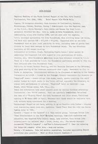
Document - Property Binder, Eltham Lower Park, Main Road, Eltham
Newspaper article: Our Beautiful Parks, Diamond Valley News, 8 March 1983, describing Eltham Lower Park and Diamond Valley Miniature Railway. Newspaper article: Diamond Valley News, 8 March 1983, Election of the ALP, Peter Stables member for Diamond Valley. Flier for Diamond Valley Miniature Railway with photograph and map. Photographs of Miniature Railway at former location at Chelsworth Park Ivanhoe. Newspaper article: New BBQ at Eltham Park, The Advertiser, 9 July 1996, about a joint project between Nillumbik Council and Eltham Rotary (On same page an article about the showcasing of indigineous plants around Nillumbik Shire offices at Civic Drive and on p4 an article about redevelopment works at Elis Cottage).main road, parks, miniature railway, chelsworth park ivanhoe, bbq facilities, civic drive, eltham lower park, eltham rotary, landscape, nillumbik shire council, ellis cottage, eltham (vic), chelsworth park, ivanhoe, diamond valley railway -
 Eltham District Historical Society Inc
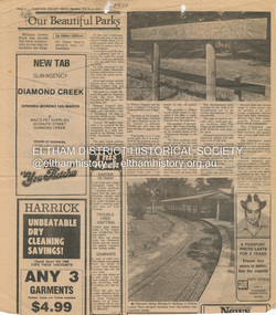
Photograph postcard, River Plenty Bridge, Greensborough
Postcard with view of bluestone bridge over the Plenty River on what is now Main Street, Greensborough. Built in 1860 by a Scottish stonemason, James Neave McKenzie. Most of the bridge was demolished in 1966 with the remaining bluestone arch preserved till 1983 when it was also demolished. This view about 1900.Digital file only Postcards scanned from the collection of Michael Aitken on loan to EDHS, 13 Feb 2018michael aitken collection, postcards, greensborough, plenty river bridge, plenty river -
 Glen Eira Historical Society
Document - Burreel
This file contains one item. 1. Auction leaflets for two periods of sale, 5 April and 30 April, years unknown, possibly 1990’s. Articles give same photograph of home, sketch of home and interior plan layout. Also includes history of Burreel to 1982/1983.burreel, biggin and scott, auctions, biggin kevin, lawson graeme, elsternwick, victorian style, mansions, stephen francis, glenhuntly road, buxton family, allen george, music, neate mary, nursing homes, alexander enid, cellars, bricks, bluestone, slate, verandas, fireplaces, plaster moulds, cool stores, gas lighting, cast iron works, architectural features, gardens -
Moorabbin Air Museum
Document (Item) - Parachute Assembly Decelleration Type 936-71
Description: Australian Aircraft Industry in decline during 1980s. Published by the GAF ~ February 1983 (02/83). Summary by GAF lists RAAF Mirage servicing and spares,offset work for FFG helicopter, and Airbus. Concept development phase for Winnin naval decoy, M7 Ika Level of Importance: . -
 Uniting Church Archives - Synod of Victoria
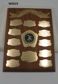
Award - Wooden Shield
Winners: Uniting Premiers 1983; Dennington Red Premiers 1984; Salvation Army Premiers 1985; O.L.H.C. Navy Premiers & Premiers 1986; Team Award 1991 Uniting Blue; O.L.H.C. Orange Premiers 1987; St Joseph's Premiers + Champions 1988; St Joseph's Premiers 1989.Solid wood shield with eleven metal award plates on the front, three of which are blank.Front: "ROBYN MINNS SHIELD" "W.I.C.N.A. UNDER 12 DIVISION 1" Handwritten on back: "MADE FROM THE ELM BOTANIC GARDENS WARRNAMBOOL (THE MONEY TREE)"warrnambool inter church netball association, robyn minns shield -
Unions Ballarat
Hayden: an Autobiography, Hayden, Bill, 1996
An autobiography of ALP MP Bill Hayden, formerly leader of the opposition. Hayden relinquished this role, after which Bob Hawke became leader and won the 1983 election. Hayden served as Australian Governor General from 1989-1996. Prior to his career as a politician, Bill Hayden was a policeman.Relevant to the history of the Australian Labor Party and Australian political history.Paper; book; 610 pages. Front cover: maroon. Dustjacket: artistic impression of Bill Hayden (colour); gold and white lettering; author's name and title.btlc, ballarat trades hall, ballarat trades and labour council, hayden, bill, hawke, bob, alp, australian labour council, politics, politicians, elections, autobiography, prime minister, governor general -
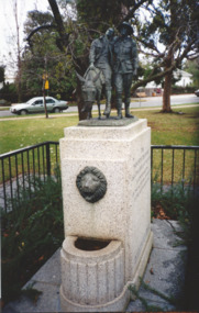 Melbourne Legacy
Photograph, The Man with the Donkey Statue
Two photos of the statue at the Shrine of a man and a donkey. It was erected in commemoration of the valour and compassion of the Australian solider by the Red Cross Society. These photos were taken at the same time as views of the Legacy Garden and the plaques at the base of trees at the Shrine of Remembrance. Photos were in a scrapbook of photos spanning 1983 to 1991.A record of a statue at the Shrine.Colour photo x 2 of the 'Man with the Donkey' statue at the Shrine of Remembrance.Printed on reverse 'shrine of remembrance, statue -
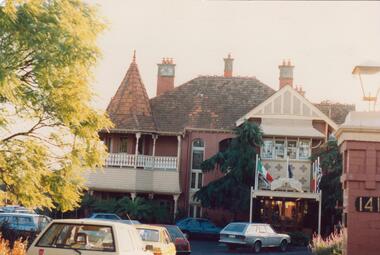 Glen Eira Historical Society
Plan - Tudor Court, Kooyong Road, 141, Caulfield North
Six page colour pamphlet of Tudor Court with interior and exterior photographs. Includes menu for functions, pamphlet describing mid week wedding specials with photos of interior, photocopy of part of Ground Floor floor plans, circa 1985, and colour photograph. All undated except floor plan in 1983.caulfield, kooyong road, tudor court, mansions, weddings, reception rooms, orlane institut de beaute, menus, architectural features, federation style, towers, chimneys, floor plans -
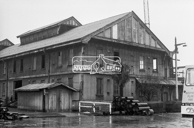 Eltham District Historical Society Inc
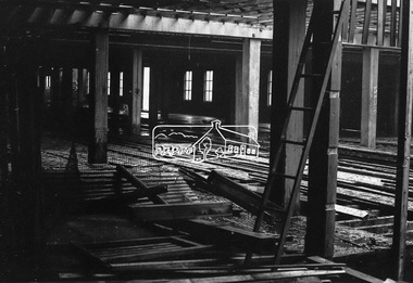
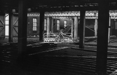
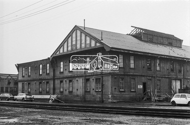
Photograph, Timber salvage during demolition of former warehouses and wool sheds at Victoria Dock, Melbourne, c.May 1974, May 1974
Oregon timber beams and Jarrah flooring were salvalged by George Coop and incorporated into extensions undertaken to 68 Mount Pleasant Road, Eltham. Timber collection/storage for the house extension took years and much was stored on the front lawn for nearly ten years. The renovations were undertaken c.1983.Digital TIFF file Scan of 35mm Kodak Plus-X black and white negative transparency. Also 5 x 13 cm black and white print68 mount pleasant road, george coop collection, victoria docks, wool shed, eltham, houses -
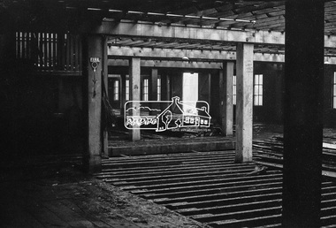 Eltham District Historical Society Inc
Photograph, Timber salvage during demolition of former warehouses and wool sheds at Victoria Dock, Melbourne, c.May 1974, May 1974
Oregon timber beams and Jarrah flooring were salvalged by George Coop and incorporated into extensions undertaken to 68 Mount Pleasant Road, Eltham. Timber collection/storage for the house extension took years and much was stored on the front lawn for nearly ten years. The renovations were undertaken c.1983.Digital TIFF file Scan of 35mm Kodak Plus-X black and white negative transparency. Also 5 x 13 cm black and white print68 mount pleasant road, george coop collection, victoria docks, wool shed, eltham, houses -
 St Kilda Historical Society
Photograph - Photo map, 28/01/1951
One of a series of photo-maps produced for the Department of Crown Lands and Survey (1857-1983). For correlation with a current map, and access to other historical photo maps of Victoria, see the Historic Photo-Maps Index published by the Department of Environment, Land, Water and Planning at https://services.land.vic.gov.au/DELWPmaps/historical-photomaps/Black and white aerial photograph1424-45 SECRET 534 Run 18 Lens 12" Melbourne Metropolitan 12150 28.1.51 M639albert park, st kilda junction, st kilda pier, catani gardens, st kilda, prahran, albert park lake, 1951, middle park, st kilda beach, windsor -
 St Kilda Historical Society
Photograph - Photo map, 17/01/1951
One of a series of photo-maps produced for the Department of Crown Lands and Survey (1857-1983). For correlation with a current map, and access to other historical photo maps of Victoria, see the Historic Photo-Maps Index published by the Department of Environment, Land, Water and Planning at https://services.land.vic.gov.au/DELWPmaps/historical-photomaps/Black and white aerial photograph1414-21 538 Run 19 Lens 12" Melbourne Metropolitan 12150 17.1.51 M586st kilda, st kilda botanical gardens, peanut farm, elwood, 1951, point ormond, elwood canal, st kilda beach -
 St Kilda Historical Society
Photograph - Photo map, 28/01/1951
One of a series of photo-maps produced for the Department of Crown Lands and Survey (1857-1983). For correlation with a current map, and access to other historical photo maps of Victoria, see the Historic Photo-Maps Index published by the Department of Environment, Land, Water and Planning at https://services.land.vic.gov.au/DELWPmaps/historical-photomaps/Black and white aerial photograph1424-118 534 Run 20 Lens 12" Melbourne Metropolitan 12150 18.1.51M639elwood, point ormond, elwood park, elsternwick park, elwood beach, 1951 -
 St Kilda Historical Society
Photograph - Photo map, 17/01/1951
One of a series of photo-maps produced for the Department of Crown Lands and Survey (1857-1983). For correlation with a current map, and access to other historical photo maps of Victoria, see the Historic Photo-Maps Index published by the Department of Environment, Land, Water and Planning at https://services.land.vic.gov.au/DELWPmaps/historical-photomaps/Black and white aerial photograph1414-20 538 Run 19 Lens 12" Melbourne Metropolitan 12150 17.1.51 M586elwood, elsternwick, st kilda east, balaclava, ripponlea, 1951 -
 St Kilda Historical Society
Photograph - Photo map, 28/01/1951
One of a series of photo-maps produced for the Department of Crown Lands and Survey (1857-1983). For correlation with a current map, and access to other historical photo maps of Victoria, see the Historic Photo-Maps Index published by the Department of Environment, Land, Water and Planning at https://services.land.vic.gov.au/DELWPmaps/historical-photomaps/Black and white aerial photograph1424-44 534 Run 18 Lens 12" Melbourne Metropolitan 12150 28.1.51 M639 -
 St Kilda Historical Society
Photograph - Photo map, 28/01/1951
One of a series of photo-maps produced for the Department of Crown Lands and Survey (1857-1983). For correlation with a current map, and access to other historical photo maps of Victoria, see the Historic Photo-Maps Index published by the Department of Environment, Land, Water and Planning at https://services.land.vic.gov.au/DELWPmaps/historical-photomaps/Black and white aerial photograph1424-43 534 Run 18 Lens 12" Melbourne Metropolitan 12150 28.1.51 M639armadale, malvern, st kilda cemetery, caulfield north, st kilda east, 1951 -
 St Kilda Historical Society
Photograph - Photo map, 30/01/1960
One of a series of photo-maps produced for the Department of Crown Lands and Survey (1857-1983). For correlation with a current map, and access to other historical photo maps of Victoria, see the Historic Photo-Maps Index published by the Department of Environment, Land, Water and Planning at https://services.land.vic.gov.au/DELWPmaps/historical-photomaps/Black and white aerial photographVic 1093-62 Melbourne & Metropolitan Project Run 21 30.1.60 Lens 10" 8.200middle park, albert park, catani gardens, st kilda west, 1960 -
 St Kilda Historical Society
Photograph - Photo map, 30/01/1960
One of a series of photo-maps produced for the Department of Crown Lands and Survey (1857-1983). For correlation with a current map, and access to other historical photo maps of Victoria, see the Historic Photo-Maps Index published by the Department of Environment, Land, Water and Planning at https://services.land.vic.gov.au/DELWPmaps/historical-photomaps/Black and white aerial photographVic 1093-60 Melbourne & Metropolitan Project Run 21 30.1.60 Lens 10" 8.200st kilda, albert park, prahran, windsor, south yarra, 1960 -
 St Kilda Historical Society
Photograph - Photo map, 30/01/1960
One of a series of photo-maps produced for the Department of Crown Lands and Survey (1857-1983). For correlation with a current map, and access to other historical photo maps of Victoria, see the Historic Photo-Maps Index published by the Department of Environment, Land, Water and Planning at https://services.land.vic.gov.au/DELWPmaps/historical-photomaps/Black and white aerial photographVic 1092-36 Melbourne & Metropolitan Project Run 22 30.1.60 Lens 10" 8.200st kilda, st kilda pier, st kilda beach, catani gardens, 1960 -
 St Kilda Historical Society
Photograph - Photo map, 30/01/1960
One of a series of photo-maps produced for the Department of Crown Lands and Survey (1857-1983). For correlation with a current map, and access to other historical photo maps of Victoria, see the Historic Photo-Maps Index published by the Department of Environment, Land, Water and Planning at https://services.land.vic.gov.au/DELWPmaps/historical-photomaps/Black and white aerial photographVic 1092-38 Melbourne & Metropolitan Project Run 22 30.1.60 Lens 10" 8.200st kilda, st kilda beach, st kilda pier, catani gardens, 1960, st kilda botanical gardens, peanut farm -
 St Kilda Historical Society
Photograph - Photo map, 30/01/1960
One of a series of photo-maps produced for the Department of Crown Lands and Survey (1857-1983). For correlation with a current map, and access to other historical photo maps of Victoria, see the Historic Photo-Maps Index published by the Department of Environment, Land, Water and Planning at https://services.land.vic.gov.au/DELWPmaps/historical-photomaps/Black and white aerial photographVic 1092-40 Melbourne & Metropolitan Project Run 22 30.1.60 Lens 10" 8.200st kilda east, balaclava, ripponlea, st kilda cemetery, 1960 -
 St Kilda Historical Society
Photograph - Photo map, 30/01/1960
One of a series of photo-maps produced for the Department of Crown Lands and Survey (1857-1983). For correlation with a current map, and access to other historical photo maps of Victoria, see the Historic Photo-Maps Index published by the Department of Environment, Land, Water and Planning at https://services.land.vic.gov.au/DELWPmaps/historical-photomaps/Black and white aerial photographVic 1092-42 Melbourne & Metropolitan Project Run 22 30.1.60 Lens 10" 8.200malvern, caulfield, caulfield park, 1960 -
 St Kilda Historical Society
Photograph - Photo map, 30/01/1960
One of a series of photo-maps produced for the Department of Crown Lands and Survey (1857-1983). For correlation with a current map, and access to other historical photo maps of Victoria, see the Historic Photo-Maps Index published by the Department of Environment, Land, Water and Planning at https://services.land.vic.gov.au/DELWPmaps/historical-photomaps/Black and white aerial photographVic 1091-112 Melbourne & Metropolitan Project Run 23East 30.1.1960 Lens 10" 8.200elwood, point ormond, elwood park, elwood canal, 1960 -
 St Kilda Historical Society
Photograph - Photo map, 30/01/1960
One of a series of photo-maps produced for the Department of Crown Lands and Survey (1857-1983). For correlation with a current map, and access to other historical photo maps of Victoria, see the Historic Photo-Maps Index published by the Department of Environment, Land, Water and Planning at https://services.land.vic.gov.au/DELWPmaps/historical-photomaps/Black and white aerial photographVic 1091-110 Melbourne & Metropolitan Project Run 23East 30.1.60 Lens 10" 8.200elwood, elsternwick, elsternwick park, ripponlea, st kilda east, caulfield, balaclava, 1960