Showing 6955 items matching " central"
-
 Ararat Gallery TAMA
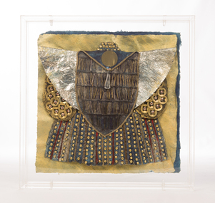
Mixed media, Irusaq Presenter at Arm's Robe, 1986-1989
“All Irusagi robes of office are highly symbolic. Generally black or dark blue, they are richly jewelled and embroidered; each one individually designed for its owner, as he, or she, takes office at the central court. The miniature is a record of this office. This, the Armourer’s Robe is typical of the richly decorated formal styles of the 10” to 12" Centuries Post Imperium. The symbolism is obvious: oversleeves of silver, to indicate one of the metals used in the making of weapons; decorative daggers, indicative of the famous throwing and fighting knives; studs, symbolising protective armour; and touches of red alongside the predominating metal, to represent the shedding of blood, (a minor theme, because bloodshed is undesirable). The Void, the centre of Irusaqu worship is always shown on this Robe, because all fighting men or women have a deep religious responsibility to obey the Voidic code. Lastly, the jewel, with its elongated triangle, forms the ancient symbol of Man, at the base of the Void, but not subordinate to it.” -Inga Hunter -
 Kew Historical Society Inc
Plan - Subdivision Plan, Balwyn Theatre and Shop Sites, circa 1927-28, c.1927-28
The Kew Historical Society's map collection includes a substantial number of real estate subdivision plans, mainly of Kew but also of surrounding suburbs in Melbourne. Most of the subdivision plans date from the 1920s and 1930s when the districts old homes and local farmland were being split up to accommodate residential growth in the postwar period. These early plans were assembled by a local firm, Jas R Mather & McMillan, which had an office in Cotham Road. Many of the plans, and sometimes photos, were annotated by the agents. The ‘new’ Balwyn Picture Theatre was built and owned by Balwyn Theatres Pty Ltd in ca. 1928. By 1930, this first Balwyn Theatre was destroyed by fire after a break-in. Following the fire, a new cinema was constructed. This plan for a Cinema and eleven shops presumably dates from 1927/28 when the Company announced that this location in Whitehorse Road ‘was the most central and best suited [area] for their Theatre and shops’.Subdivision plans are historically important documents used as evidence for the growth of suburbs in Australia. They frequently provide information about when the land was sold as well as evidence relating to surveyors and real estate and financial agents. The numerous subdivision plans in the Kew Historical Society's collection represent working documents, ranging from the initial sketches made in planning a subdivision to printed plans on which auctioneers or agents listed the prices for which individual lots were sold. In a number of cases, the reverse of a subdivision plan in the collection includes a photograph of a house that was also for sale by the agent. These photographs provide significant heritage information relating house design and decoration, fencing and household gardens.The photograph may also be aesthetically significant depending on the importance of the photographic atelier.Subdivision plan showing the Balwyn Theatre and its adjoining shop sites in Whitehorse Road Balwyn. The 11 shop sites were noted for their depth (133 ft - 145 ft. [Map.0041]balwyn theatre -- balwyn (vic.), subdivisions -- balwyn (vic), subdivision plans -
 Kew Historical Society Inc
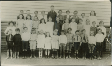
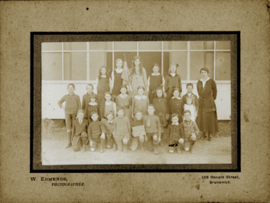
Photograph - Kew East State School
State School No. 3161 was originally situated between High Street (then Bulleen Road) and Kilby Road adjacent to Burke Road and was officially opened on 25th April 1892 with Mr Roland Gray as its Headmaster. With more people moving into the district, the School was moved in 1905 to Strathalbyn Street. (This site was to became the Kew East Bowling Club, and is now a Kindergarten.) 1929 saw the erection of the brick Infant School adjacent to the main building. In subsequent years many other buildings were added, including a weatherboard ‘Rural’ school, a brick library, an administration block, several portables, and a Community Music Centre and shelter sheds, culminating in the opening in March 2011 of the Commonwealth funded new Music/Sports Complex. At one time it was called Kew East Central School and included years 7 & 8. When Kew High School started, the high school students were accommodated there whilst their buildings were being completed.Undated, original print positive of a co-educational class of students at Kew East State School. Margery Canham (nee Nickell) and the teacher, Miss Sybil North, are named in an inscription on the reverse of the mount. "Kew East Primary School. Miss Sybil North teacher. Margery Canham (nee Nickell) 2nd row, 3rd rightkew east primary school, margery canham, margery nickell, elizabeth angel, kew east state school -
 Kew Historical Society Inc
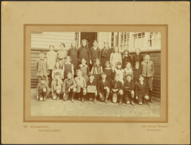
Photograph - Kew East Country School, 1919
State School No. 3161 was originally situated between High Street (then Bulleen Road) and Kilby Road adjacent to Burke Road and was officially opened on 25th April 1892 with Mr Roland Gray as its Headmaster. With more people moving into the district, the School was moved in 1905 to Strathalbyn Street. (This site was to became the Kew East Bowling Club, and is now a Kindergarten.) 1929 saw the erection of the brick Infant School adjacent to the main building. In subsequent years many other buildings were added, including a weatherboard ‘Rural’ school, a brick library, an administration block, several portables, and a Community Music Centre and shelter sheds, culminating in the opening in March 2011 of the Commonwealth funded new Music/Sports Complex. At one time it was called Kew East Central School and included years 7 & 8. When Kew High School started, the high school students were accommodated there whilst their buildings were being completed.Original print positive, mounted on board of a co-educational class of students at Kew East 'Country School'. Howard Nickell is identified in an inscription on the reverse of the mount. The Age newspaper on 6 March 1906 included in News of the Day that: "At a meeting of the Executive Council yesterday it was decided to proclaim the following State schools as training schools under the provisions of the Teachers' Act: Brunswick 1213; Queensberry-street, Carlton 2365; Kew East 3161; and Queensberry-street, North Melbourne 307. These schools have been specially selected and staffed in order that teachers in training and junior teachers may study the methods of the best teachers in special kinds of work. The infant class is the special feature at Brunswick, while Kew East will be a model of the methods of a country school. The schools at Queensberry-street, North Carlton and North Melbourne, are to be more especially connected with the training college."Obverse: Written on held chalk board: "Kew East 3161 / Country School / 1919". Reverse: "Howard Nickell, 2nd row, left - end of row"kew east primary school, margery canham, margery nickell, elizabeth angel, kew east state school, kew east country school -
 Kew Historical Society Inc
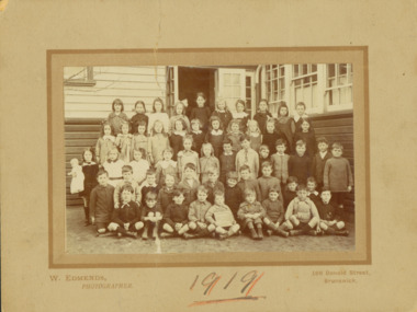
Photograph - Kew East State School, 1919
State School No. 3161 was originally situated between High Street (then Bulleen Road) and Kilby Road adjacent to Burke Road and was officially opened on 25th April 1892 with Mr Roland Gray as its Headmaster. With more people moving into the district, the School was moved in 1905 to Strathalbyn Street. (This site was to became the Kew East Bowling Club, and is now a Kindergarten.) 1929 saw the erection of the brick Infant School adjacent to the main building. In subsequent years many other buildings were added, including a weatherboard ‘Rural’ school, a brick library, an administration block, several portables, and a Community Music Centre and shelter sheds, culminating in the opening in March 2011 of the Commonwealth funded new Music/Sports Complex. At one time it was called Kew East Central School and included years 7 & 8. When Kew High School started, the high school students were accommodated there whilst their buildings were being completed.Original print positive, mounted on board of a co-educational class of students at Kew East 'Country School'. Margery Canham (nee Nickell) is identified in an inscription on the reverse of the mount. The Age newspaper on 6 March 1906 included in News of the Day that: "At a meeting of the Executive Council yesterday it was decided to proclaim the following State schools as training schools under the provisions of the Teachers' Act: Brunswick 1213; Queensberry-street, Carlton 2365; Kew East 3161; and Queensberry-street, North Melbourne 307. These schools have been specially selected and staffed in order that teachers in training and junior teachers may study the methods of the best teachers in special kinds of work. The infant class is the special feature at Brunswick, while Kew East will be a model of the methods of a country school. The schools at Queensberry-street, North Carlton and North Melbourne, are to be more especially connected with the training college."Obverse: Written on held chalk board: "Kew East 3161 / ? Grades / 1919". Reverse: "Margery Nickell, 4th row, back right"kew east primary school, margery canham, margery nickell, elizabeth angel, kew east state school, kew east country school -
 Kew Historical Society Inc
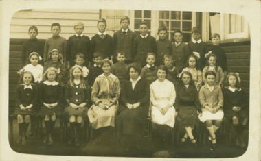
Photograph - Kew East Primary School, 1919
State School No. 3161 was originally situated between High Street (then Bulleen Road) and Kilby Road adjacent to Burke Road and was officially opened on 25th April 1892 with Mr Roland Gray as its Headmaster. With more people moving into the district, the School was moved in 1905 to Strathalbyn Street. (This site was to became the Kew East Bowling Club, and is now a Kindergarten.) 1929 saw the erection of the brick Infant School adjacent to the main building. In subsequent years many other buildings were added, including a weatherboard ‘Rural’ school, a brick library, an administration block, several portables, and a Community Music Centre and shelter sheds, culminating in the opening in March 2011 of the Commonwealth funded new Music/Sports Complex. At one time it was called Kew East Central School and included years 7 & 8. When Kew High School started, the high school students were accommodated there whilst their buildings were being completed.Original print positive, mounted on board of a co-educational class of students at Kew East 'Country School'. The Age newspaper on 6 March 1906 included in News of the Day that: "At a meeting of the Executive Council yesterday it was decided to proclaim the following State schools as training schools under the provisions of the Teachers' Act: Brunswick 1213; Queensberry-street, Carlton 2365; Kew East 3161; and Queensberry-street, North Melbourne 307. These schools have been specially selected and staffed in order that teachers in training and junior teachers may study the methods of the best teachers in special kinds of work. The infant class is the special feature at Brunswick, while Kew East will be a model of the methods of a country school. The schools at Queensberry-street, North Carlton and North Melbourne, are to be more especially connected with the training college."Obverse: Written on chalk slate - "Kew East / 3161 / Country School /19??"kew east primary school, margery canham, margery nickell, elizabeth angel, kew east state school, kew east country school, erik nickell -
 Kew Historical Society Inc
Photograph - Kew East State School
State School No. 3161 was originally situated between High Street (then Bulleen Road) and Kilby Road adjacent to Burke Road and was officially opened on 25th April 1892 with Mr Roland Gray as its Headmaster. With more people moving into the district, the School was moved in 1905 to Strathalbyn Street. (This site was to became the Kew East Bowling Club, and is now a Kindergarten.) 1929 saw the erection of the brick Infant School adjacent to the main building. In subsequent years many other buildings were added, including a weatherboard ‘Rural’ school, a brick library, an administration block, several portables, and a Community Music Centre and shelter sheds, culminating in the opening in March 2011 of the Commonwealth funded new Music/Sports Complex. At one time it was called Kew East Central School and included years 7 & 8. When Kew High School started, the high school students were accommodated there whilst their buildings were being completed.Original print positive of a co-educational class of students at Kew East State School. Howard Nickell is identified in an inscription on the reverse of the mount. The Age newspaper on 6 March 1906 included in News of the Day that: "At a meeting of the Executive Council yesterday it was decided to proclaim the following State schools as training schools under the provisions of the Teachers' Act: Brunswick 1213; Queensberry-street, Carlton 2365; Kew East 3161; and Queensberry-street, North Melbourne 307. These schools have been specially selected and staffed in order that teachers in training and junior teachers may study the methods of the best teachers in special kinds of work. The infant class is the special feature at Brunswick, while Kew East will be a model of the methods of a country school. The schools at Queensberry-street, North Carlton and North Melbourne, are to be more especially connected with the training college."Reverse: "Howard Nickell. Back Row. Second right."kew east primary school, elizabeth angel, kew east state school, howard nickell -
 Kew Historical Society Inc
Photograph - Kew East State School
State School No. 3161 was originally situated between High Street (then Bulleen Road) and Kilby Road adjacent to Burke Road and was officially opened on 25th April 1892 with Mr Roland Gray as its Headmaster. With more people moving into the district, the School was moved in 1905 to Strathalbyn Street. (This site was to became the Kew East Bowling Club, and is now a Kindergarten.) 1929 saw the erection of the brick Infant School adjacent to the main building. In subsequent years many other buildings were added, including a weatherboard ‘Rural’ school, a brick library, an administration block, several portables, and a Community Music Centre and shelter sheds, culminating in the opening in March 2011 of the Commonwealth funded new Music/Sports Complex. At one time it was called Kew East Central School and included years 7 & 8. When Kew High School started, the high school students were accommodated there whilst their buildings were being completed.Original print positive, mounted on board of a co-educational class of students at Kew East State School. Jean Nickell is identified in an inscription on the reverse of the mount. The Age newspaper on 6 March 1906 included in News of the Day that: "At a meeting of the Executive Council yesterday it was decided to proclaim the following State schools as training schools under the provisions of the Teachers' Act: Brunswick 1213; Queensberry-street, Carlton 2365; Kew East 3161; and Queensberry-street, North Melbourne 307. These schools have been specially selected and staffed in order that teachers in training and junior teachers may study the methods of the best teachers in special kinds of work. The infant class is the special feature at Brunswick, while Kew East will be a model of the methods of a country school. The schools at Queensberry-street, North Carlton and North Melbourne, are to be more especially connected with the training college."Obverse on chalkboard: "Kew East / 3161 / 1 & 2 Grades" / Reverse: "Jean Nickell. Back row 6th left"kew east primary school, elizabeth angel, kew east state school, jean nickell, w edmends -
 Kew Historical Society Inc
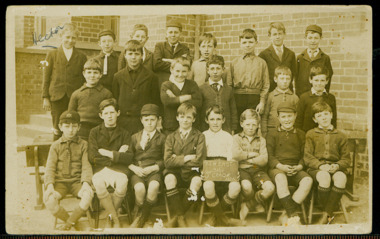
Photograph - Kew East State School, 1926
State School No. 3161 was originally situated between High Street (then Bulleen Road) and Kilby Road adjacent to Burke Road and was officially opened on 25th April 1892 with Mr Roland Gray as its Headmaster. With more people moving into the district, the School was moved in 1905 to Strathalbyn Street. (This site was to became the Kew East Bowling Club, and is now a Kindergarten.) 1929 saw the erection of the brick Infant School adjacent to the main building. In subsequent years many other buildings were added, including a weatherboard ‘Rural’ school, a brick library, an administration block, several portables, and a Community Music Centre and shelter sheds, culminating in the opening in March 2011 of the Commonwealth funded new Music/Sports Complex. At one time it was called Kew East Central School and included years 7 & 8. When Kew High School started, the high school students were accommodated there whilst their buildings were being completed.Original print positive of class of boys at Kew East State School. Hector Canham is identified in an inscription on the reverse of the mount. The Age newspaper on 6 March 1906 included in News of the Day that: "At a meeting of the Executive Council yesterday it was decided to proclaim the following State schools as training schools under the provisions of the Teachers' Act: Brunswick 1213; Queensberry-street, Carlton 2365; Kew East 3161; and Queensberry-street, North Melbourne 307. These schools have been specially selected and staffed in order that teachers in training and junior teachers may study the methods of the best teachers in special kinds of work. The infant class is the special feature at Brunswick, while Kew East will be a model of the methods of a country school. The schools at Queensberry-street, North Carlton and North Melbourne, are to be more especially connected with the training college."Obverse : "Hector [arrowed]" / Reverse: "5th Grade. Hector Canham. Back row left."kew east primary school, elizabeth angel, kew east state school, hector canham -
 Kew Historical Society Inc
Photograph - Kew East State School
State School No. 3161 was originally situated between High Street (then Bulleen Road) and Kilby Road adjacent to Burke Road and was officially opened on 25th April 1892 with Mr Roland Gray as its Headmaster. With more people moving into the district, the School was moved in 1905 to Strathalbyn Street. (This site was to became the Kew East Bowling Club, and is now a Kindergarten.) 1929 saw the erection of the brick Infant School adjacent to the main building. In subsequent years many other buildings were added, including a weatherboard ‘Rural’ school, a brick library, an administration block, several portables, and a Community Music Centre and shelter sheds, culminating in the opening in March 2011 of the Commonwealth funded new Music/Sports Complex. At one time it was called Kew East Central School and included years 7 & 8. When Kew High School started, the high school students were accommodated there whilst their buildings were being completed.Original print positive of a co-educational class at Kew East State School. Margaret Nickell is identified in an inscription on the reverse of the mount. The Age newspaper on 6 March 1906 included in News of the Day that: "At a meeting of the Executive Council yesterday it was decided to proclaim the following State schools as training schools under the provisions of the Teachers' Act: Brunswick 1213; Queensberry-street, Carlton 2365; Kew East 3161; and Queensberry-street, North Melbourne 307. These schools have been specially selected and staffed in order that teachers in training and junior teachers may study the methods of the best teachers in special kinds of work. The infant class is the special feature at Brunswick, while Kew East will be a model of the methods of a country school. The schools at Queensberry-street, North Carlton and North Melbourne, are to be more especially connected with the training college."Obverse : "Margery [arrowed]" / Reverse: "Margery Nickell. 2nd row left end. Teacher Miss Grey."kew east primary school, elizabeth angel, kew east state school, margery nickell -
 Kew Historical Society Inc
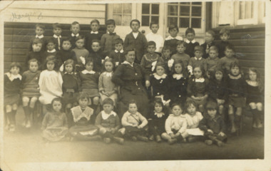
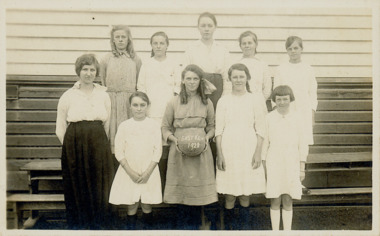
Photograph - Kew East State School, 1921-28
State School No. 3161 was originally situated between High Street (then Bulleen Road) and Kilby Road adjacent to Burke Road and was officially opened on 25th April 1892 with Mr Roland Gray as its Headmaster. With more people moving into the district, the School was moved in 1905 to Strathalbyn Street. (This site was to became the Kew East Bowling Club, and is now a Kindergarten.) 1929 saw the erection of the brick Infant School adjacent to the main building. In subsequent years many other buildings were added, including a weatherboard ‘Rural’ school, a brick library, an administration block, several portables, and a Community Music Centre and shelter sheds, culminating in the opening in March 2011 of the Commonwealth funded new Music/Sports Complex. At one time it was called Kew East Central School and included years 7 & 8. When Kew High School started, the high school students were accommodated there whilst their buildings were being completed.Original print positive of a class of girls at Kew East State School. The Age newspaper on 6 March 1906 included in News of the Day that: "At a meeting of the Executive Council yesterday it was decided to proclaim the following State schools as training schools under the provisions of the Teachers' Act: Brunswick 1213; Queensberry-street, Carlton 2365; Kew East 3161; and Queensberry-street, North Melbourne 307. These schools have been specially selected and staffed in order that teachers in training and junior teachers may study the methods of the best teachers in special kinds of work. The infant class is the special feature at Brunswick, while Kew East will be a model of the methods of a country school. The schools at Queensberry-street, North Carlton and North Melbourne, are to be more especially connected with the training college."Obverse : "East Kew 1921 [sic] / Reverse: "East Kew 1928 [sic]"kew east primary school, elizabeth angel, kew east state school -
 Kew Historical Society Inc
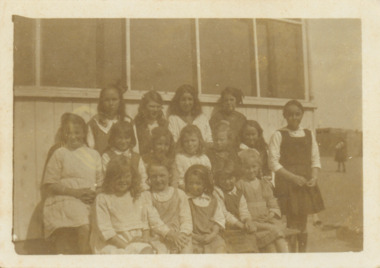
Photograph - Kew East State School
State School No. 3161 was originally situated between High Street (then Bulleen Road) and Kilby Road adjacent to Burke Road and was officially opened on 25th April 1892 with Mr Roland Gray as its Headmaster. With more people moving into the district, the School was moved in 1905 to Strathalbyn Street. (This site was to became the Kew East Bowling Club, and is now a Kindergarten.) 1929 saw the erection of the brick Infant School adjacent to the main building. In subsequent years many other buildings were added, including a weatherboard ‘Rural’ school, a brick library, an administration block, several portables, and a Community Music Centre and shelter sheds, culminating in the opening in March 2011 of the Commonwealth funded new Music/Sports Complex. At one time it was called Kew East Central School and included years 7 & 8. When Kew High School started, the high school students were accommodated there whilst their buildings were being completed.Original print positive of a class of girls at what is believed to be Kew East State School. The Age newspaper on 6 March 1906 included in News of the Day that: "At a meeting of the Executive Council yesterday it was decided to proclaim the following State schools as training schools under the provisions of the Teachers' Act: Brunswick 1213; Queensberry-street, Carlton 2365; Kew East 3161; and Queensberry-street, North Melbourne 307. These schools have been specially selected and staffed in order that teachers in training and junior teachers may study the methods of the best teachers in special kinds of work. The infant class is the special feature at Brunswick, while Kew East will be a model of the methods of a country school. The schools at Queensberry-street, North Carlton and North Melbourne, are to be more especially connected with the training college."Reverse : "Margery Nickell. 2nd row, 2nd left"kew east primary school, elizabeth angel, kew east state school, margery nickell -
![View of portion of the City of Sandhurst, as seen from the hill, Camp Reserve / [by] Nicholas Caire, circa 1876](/media/collectors/550653872162f11fb04854aa/items/57774295d0cdd10a5c0eb588/item-media/57774325d0cdd10a5c0f0b71/item-fit-380x285.jpg) Kew Historical Society Inc
Kew Historical Society IncPhotograph, Anglo-Australasian Photographic Company, View of portion of the City of Sandhurst, as seen from the hill, Camp Reserve, c. 1876
Nicholas Caire was born on Guernsey in the Channel Islands in 1837. He arrived in Adelaide with his parents in about 1860. In 1867, following photographic journeys in Gippsland, he opened a studio in Adelaide. From 1870 to 1876 he lived and worked in Talbot in Central Victoria. In 1876 he purchased T. F. Chuck's studios in the Royal Arcade Melbourne. In 1885, following the introduction of dry plate photography, he began a series of landscape series, which were commercially successful. As a photographer, he travelled extensively through Victoria, photographing places few of his contemporaries had previously seen. He died in 1918. Reference: Jack Cato, 'Caire, Nicholas John (1837–1918)', Australian Dictionary of Biography, National Centre of Biography, Australian National University, http://adb.anu.edu.au/biography/caire-nicholas-john-3139/text3683, published first in hardcopy 1969, accessed online 1 July 2016.An original, rare photograph from the series 'Views of Victoria: General Series' by the photographer, Nicholas Caire (1837-1918). The series of 60 photographs that comprise the series was issued c. 1876 and reinforced a neo-Romantic view of the Australian landscape to which a growing nationalist movement would respond. Nicholas Caire was active as a photographer in Australia from 1858 until his death in 1918. His vision of the Australian bush and pioneer life had a counterpart in the works of Henry Lawson and other nationalist poets, authors and painters.Albumen Silver Photograph, mounted on Board.printed in ink on support l.c.: VIEW OF PORTION OF THE CITY OF SANDHURST, AS SEEN FROM THE HILL, CAMP RESERVE / COPYRIGHT REGISTERED. printed in ink on support reverse c.: VIEWS OF VICTORIA. / (GENERAL SERIES.) / No. 4. / VIEW OF PORTION OF THE CITY OF SANDHURST AS SEEN FROM THE HILL, CAMP RESERVE. / The Camp Reserve is the principal public promenade in this City. The Rotunda in the foreground, formerly used / by the local bands on festive occasions, is now regarded as a relic of the past. To the right of the picture is shown the / City of Sandhurst claim, supposed to be on the Hustler's line of reef. St. Paul's Church tower may be seen in the / distance. To the left of the picture Williamstown-street branches out from Pall Mall. On one side of the street is the / far-famed Shamrock Hotel; on the other stands the Bank of Australasia, with St. James's Hall immediately behind it. printed in ink on support reverse l.c.l.: J.W. FORBES, Agent, printed in ink on support reverse l.c.: ANGLO-AUSTRALASIAN PHOTOGRAPHIC COMPANY, MELBOURNE. printed in ink on support reverse l.c.r.: 10 Temple Court, Collins Street West.nicholas caire (1837-1918), landscape photography -
 Surrey Hills Historical Society Collection
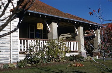
Photograph - Digital photograph, George L Coop, 688 Whitehorse Road, Mont Albert 1958, 1958
The donor George Lister Coop was about 21 years of age when he took this photo in 1958 of his family home. His parents were George Burton Coop (b c1906 Williamstown; died aged 54 years at Mont Albert) and Winsome Alice (MS: Trewartha) who married in 1936. They are first listed at this address in the electoral roll in 1937. They had 2 children: George Lister Coop - born St Georges Hospital, 8/10/1937 and Alison - born c1945. However the donor informed that he initially attended Chatham State School because his first home was the Spanish Mission style flats at 346 Whitehorse Road, opposite Brenbeal Street, Balwyn. When his grandparents died, the family moved to 688 Whitehorse Road and he then attended Mont Albert Central School. Alison being younger did not go to Chatham Primary. A digital copy of a colour photo showing detail of the front veranda of 688 Whitehorse Road. The house is white weatherboard in a modified Californian bungalow style with a tiled roof and the carport built within the roofline. The balustrades and finials of the veranda are simple with occasional feature planks with a tulip detail. A bird cage hangs from the veranda. The veranda is supported by rough-cast sturdy pillars.george l coop, whitehorse road, mont albert, uniting church, californian bungalow -
 City of Greater Bendigo - Civic Collection
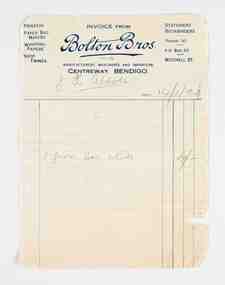
Financial record - Invoice, Bolton Brothers Printers, Bolton Brothers, 1920
Benjamin Bolton and his two eldest sons, William and Arthur, began a printing business known as Bolton & Sons on March 25, 1885. The location of the original printing business was in High Street, Bendigo but later moved to Williamson Street where the business underwent a name change to Bolton Bros and expanded into manufacturing paper bags and other stationery lines. In 1902, Bolton Bros moved to 43 Mitchell Street which housed the retail stationery department and the main office, while the printing factory was on the second and third floors. Next door at 47 Mitchell Street the wholesale division and machine service department operated. William and Arthur Bolton and their sons travelled throughout central and northern Victoria selling their own products and representing other companies. Bolton Bros continue to trade today with fifth generation family ownership continuing the tradition. (Fn https://www.boltonbros.com.au/about-us)Printed and handwritten paper invoice from Bolton Bros. to JH Abbott dated 14/1/20 for nibs.mayor bolton, mayor abbott, city of greater bendigo commerce, making a nation exhibition, bolton brothers printers, mayoress bolton -
 Bacchus Marsh & District Historical Society
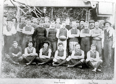
Photograph, Bacchus Marsh Football Club 1901
This is the earliest known photo of an Australian Rules football team in the Bacchus Marsh area. The photo is of 27 men and two boys standing in front of the Evans Pavilion at Maddingley Park Bacchus Marsh. The image shows players, officials and trainers, the players wearing early twentieth century playing guernseys featuring front fastenings. Some are wearing knickerbockers, some long trousers. Trainers have their towels slung over their shoulders. Men in civilian clothes, possibly club officials, are wearing suits and hats. The boys and two of the players are wearing caps, one player wearing a hat. The central figure, possibly the captain, is holding a football which has the initials B M I F C. These initials stand for "Bacchus Marsh Imperial Football Club". At this time, many football clubs used the word "imperial" in their title. This team may possibly have had the nick-name of "Imperials".This item has historic and social significance as the earliest image of one of the early sporting teams of Bacchus Marsh and district. It is evidence of the growth of importance of sport, in this case Australian Rules football, as a cultural and social activity central to the Australian ethos. It is also evidence of the dominance of the masculine ethos in the Australian culture of this time. The image has strong research value for the information it conveys about this particular club and its early participants.Photographic reproduction of earlier photographHand written below photograph "Bacchus Marsh Football Club 1901." The names Fred Pearce and Jack Bence with arrows indicating the players identified.bacchus marsh imperial football club, australian rules football -
 Wodonga & District Historical Society Inc
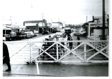
Photograph - High Street, Wodonga Level Crossing, 1954
This image is representative of many photographs illustrating the level crossing in the centre of Wodonga. Since its opening in 1873 the railway line had crossed High Street, originally called Sydney Road. It bisected the city with level crossing gates frequently stopping the flow of traffic and pedestrians as trains passed through. Signal Box B stood on the eastern side of the High Street level crossing and a big wheel closed and opened the gates. On 17th September, 1961, it was replaced by boom gates and flashing lights. The railway crossing was removed from High Street as part of the Wodonga Rail Bypass project. This involved a 5.5 kilometres bypass, the elimination of 11 level crossings and the relocation of the Wodonga station. It was moved from its original central location to a position on a new line on the northern edge of the town. The old station closed on 8 November 2008 and the new station opened on 25 June 2011.This image has local and statewide significance as it captures the former crossing in a major railway system. The railways played a critical role in opening up Victoria and connecting Australia for trade, business, social communication and transport.A black and white photo of the railway level crossing in High Street, Wodonga with gates closed. The Melbourne to Sydney railway line went through the centre of Wodonga and trains frequently held up internal vehicular and pedestrian traffic in the main street. railways wodonga, wodonga railway relocation, high st wodonga rail crossing -
 Wodonga & District Historical Society Inc
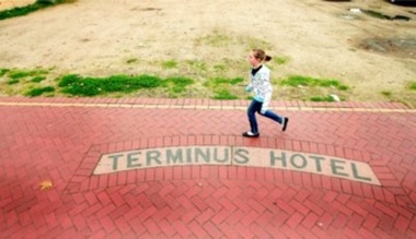
Photograph - Terminus Hotel footpath inlay
During the depression of the early 1930s, men on the dole carried out work for the Wodonga Shire Council. One of the projects during the term of councillor Mick Martin, as shire president, was to seal the footpaths in central Wodonga. Local business people supplied the cement. The police department refused to fund the cement for its section of High Street, north of the railway line, which included the police station and the courthouse. The then licensee of the Terminus Hotel offered to provide the cement for sealing the footpath in front of the police station and courthouse. This offer was made on the condition that tiles bearing the words Terminus Hotel be inserted into the footpath pointing toward the hotel.The police objected but the hotel licensee, Tex Bailey, won the day. As a result, his hotel’s tiled name was inserted into the footpath in front of the police station. Cr Mick Martin’s son, Des, wrote to the council in 1967 asking that the sign be preserved and it was moved to the Terminus Hotel and placed in the footpath there.The Terminus Hotel was one of the earliest hotels in Wodonga with clear links to the establishment of the railway line. It was an important business and meeting place for social gatherings.The name, Terminus Hotel worked into the brickwork of the footpath when they were surfaced by sustenance workers during the 1930s Depression. "TERMINUS HOTEL"hotels wodonga, businesses wodonga, terminus hotel wodonga -
 Wodonga & District Historical Society Inc
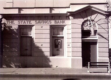
Photograph - State Bank of Victoria, Wodonga
The Title for the land on which this building stands was granted on 27 August 1857 and the land was bought by Keith Field and A. Maitland. It stood on 1 / 2 acre of land with 250 lengths down South Street and 200 lengths along Sydney Road. The 1 / 2 acre block on the northern side was also purchased by the same buyers. The State Savings Bank was built in 1915, just three years after the State Savings Bank of Victoria was established. It was branch number 731. The building served as a bank until about 1970. It is now owned and used as an office by a local law firm. It is a single storey rendered masonry building with a parapet concealing the roof. Key features of the High Street facade are horizontal bands of masonry, timber windows outlined with moulded details and ornamentation accentuated the door. A more modern branch was opened in a more central location in HIghs Street. The State Bank of Victoria was taken over by the Commonwealth Bank in 1990. These images record the premises of a bank which served the Wodonga community and businesses for many years.3 photos of the State Bank of Victoria in High Street Wodonga at various points in its history.state bank, wodonga businesses, financial institutions wodonga -
 Wodonga & District Historical Society Inc
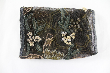
Textile - Hamilton-Smith Collection Beaded Textile c. late 1800s - early 1900s
The Hamilton-Smith collection was donated by the children of Grace Mary Hamilton-Smith nee Ellwood (1911-2004) and John Hamilton-Smith (1909-1984) who settled in Wodonga in the 1940s. The Ellwood family had lived in north-east Victoria since the late 1800s. Grace’s mother, Rosina Ellwood nee Smale, was the first teacher at Baranduda in 1888, and a foundation member of the C.W.A. Rosina and her husband Mark retired to Wodonga in 1934. Grace and John married at St. David’s Church, Albury in 1941. John was a grazier, and actively involved in Agricultural Societies. The collection contains significant items which reflect the local history of Wodonga, including handmade needlework, books, photographs, a wedding dress, maps, and material relating to the world wars. In the nineteenth and early twentieth century prior to the mass production of clothing and textiles, needlework, alongside motherhood, was the defining work of women. Hand sewing and embroidery was central in the everyday lives and domestic roles of women.This item is unique, handmade and has a known owner. It forms part of a significant and representative historical collection which reflects the local history of Wodonga. It contributes to our understanding of social and family life in early twentieth century Wodonga, as well as providing interpretative capacity for themes including local history, social history and women’s history.Bronze and gold embroidery and bead work on black mesh.needlework, beading, sewing, sew, hamilton-smith collection, hamilton-smith, ellwood, handmade, domestic, women, women's history -
 City of Kingston
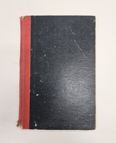
Book - Minute book, Minute book, Cheltenham Community Hospital, 1938
The Mordialloc-Cheltenham Community Hospital was a hospital in the suburb of Parkdale. Residents of Mordialloc and Chelsea worked towards a community hospital from the late 1930s. Having a community hospital meant residents who required routine surgery did not need to travel into Melbourne to the larger established hospitals. This was important at a time when few people had their own transport. For many years the Mordialloc Carnival Committee contributed to the cost of building the hospital, with one of its contributions to the ‘opening day’ appeal amounting to one thousand pounds, adding to the several thousand already committed. Construction work commenced on the Mordialloc-Cheltenham Community Hospital in 1950. on a site between Booth St and Carrier Ave on the Nepean Highway in Parkdale. The hospital opened in 1953 and serviced the community until 1996. On 1 August 1995, the hospital became a part of the Southern Health Care Network. The former hospital site is now the main location of Central Bayside Community Health Services.Black hard cover book with red spine. cheltenham, mordialloc, hospital, parkdale, health -
 Melbourne Legacy
Magazine - Newsletter, Melbourne Legacy, Legacy Newsletter September 1953, 1953
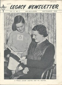
The newsletter from September 1953. It covered events for the junior legatees such as basketball and boys classes in different locations such as Auburn, East Brighton, Central, Footscray, Coburg, Fitzroy, Kew, St Kilda East and Malvern, and swimming classes. Also mentioned Longbank a holiday home in Camperdown available at reasonable rates to Legacy Widows. Also an article on job opportunities for boys in the Royal Australian Navy. A newsletter published by Legacy in this format for many years from 1942. It mentions "Issued from time to time for Private Circulation among the Sons and Daughters of Deceased Service men and Merchant Seamen who served their Country during the War of 1914-18, or the present War" Many articles on the work of Legacy, including features on boys classes, girls classes, camps, the residences and where their past residents ended up. There are some suggestion for careers and some general interest articles. Some very interesting photos.Newsletter outlining news of Junior Legatee activities.Black and white printed newsletter x 16 pages from September 1953Pencil mark on top right corner of cover 'L/Field'.boys classes, widows, activities -
 Eltham District Historical Society Inc
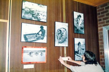
Photograph, Peter Bassett-Smith, Donald Thomson collection, 1988
Photo display relating to the work of Eltham anthropologist Professor Donald Thomson (1901-1970) who was renowned for his work researching Aborigines across Central Australia. Part of the Bicentennial/Heritage Week Display, "The Eltham Tradition", Eltham Shire Office, 17-22 April 1988. "The Photographic record which forms part of the Donald Thomson collection housed at the Museum of Victoria, by arrangement with the University of Melbourne contains 10,580 negatives. The collection also includes 5,700 artefacts and 4,500 pages of field notes. Cumbersome camera equipment and glass negatives often had to be carried hundreds of miles by pack horse, on small boars and other means. Three documentary films have been made, two by the BBC and released in over 18 countries and third, made by Academy of Science (1987) is for Year 12 Biology students. 28,000 feet of film record of Arnhem land was destroyed whilst in Commonwelath Government Custody." Two colour photographsactivities, eltham shire office, heritage display, heritage week, donald thomson, collection -
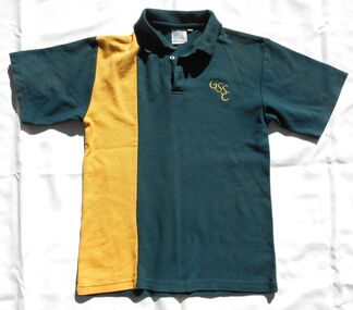 Bendigo Historical Society Inc.
Uniform - GSSC School polo shirt
Golden Square High School in the city of Bendigo, was established in temporary accommodation at Camp Hill Primary School in central Bendigo in 1960. With the completion of the new school's buildings, it moved to Golden Square in 1962, providing for Forms 1 to 6, now known as years 7 to 12. In 1978 it became a 7–10 school and was one of the original feeder schools to Bendigo Senior High School. In 1986, a Hearing Impaired Unit was established and in 1990 it underwent a name change to become Golden Square Secondary College. The Golden Square Secondary College campus closed on 28 November 2008. It merged with Kangaroo Flat and Flora Hill secondary colleges as part of the implementation of the Bendigo Education Plan. Its buildings were demolished. (Wikipedia https://en.wikipedia.org/wiki/Golden_Square_Secondary_College) This uniform collection belonged to Anna Matthews, daughter of the donor, who attended GSSC as part of the last group enrolled before the school closed in 2008. Golden Square Secondary College girl's dark green short sleeved polo shirt with 12.5 cm yellow panel on RHS of front from shoulder to hem. Yellow embroidered intertwining letters GSSC on left hand side. Size 12.Tag below collar "DUX BY DOBSONS Phone 03 9619 1122" "NAME _ _ _ _ _ _ _ _ _ " "Washing Instructions on reverse."gssc, golden square secondary college, uniform, bendigo education plan., polo shirt -
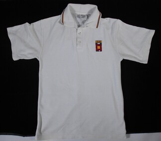 Bendigo Historical Society Inc.
Uniform - GSSC School polo shirt
Golden Square High School in the city of Bendigo, was established in temporary accommodation at Camp Hill Primary School in central Bendigo in 1960. With the completion of the new school's buildings, it moved to Golden Square in 1962, providing for Forms 1 to 6, now known as years 7 to 12. In 1978 it became a 7–10 school and was one of the original feeder schools to Bendigo Senior High School. In 1986, a Hearing Impaired Unit was established and in 1990 it underwent a name change to become Golden Square Secondary College. The Golden Square Secondary College campus closed on 28 November 2008. It merged with Kangaroo Flat and Flora Hill secondary colleges as part of the implementation of the Bendigo Education Plan. Its buildings were demolished. (Wikipedia https://en.wikipedia.org/wiki/Golden_Square_Secondary_College) This uniform collection belonged to Anna Matthews, daughter of the donor, who attended GSSC as part of the last group enrolled before the school closed in 2008. Golden Square Secondary College girl's white short sleeved polo shirt. Red, yellow and dark green stripes on the collar. White buttons. Appliqued embroidered school logo on left hand side. Size 12.Tag below collar "DUX BY DOBSONS Phone 03 9619 1122" "NAME _ _ _ _ _ _ _ _ _ " "Washing Instructions on reverse."gssc, golden square secondary college, uniform, bendigo education plan., polo shirt -
 Bacchus Marsh & District Historical Society
Map, Plan of part of the road district of Bacchus Marsh circa 1856-1862
Local government in much of Victoria including the Bacchus Marsh area began with the formation of 'local committees'. These local committees could make representations to a Central Road Board regarding plans for road construction. Road construction and maintenance were seen as the essential tasks of these early local government authorities. By 1856 the local committee in Bacchus Marsh was constituted as the Bacchus Marsh Road District. This entity continued until 1862 when the name changed to the Bacchus Marsh and Maddingley Road District. This new entity lasted until 1871 when the local government authority in accordance with new statewide legislation became known as the Shire of Bacchus Marsh. The title of this plan being a plan of 'a portion of the road district of Bacchus Marsh' suggests that the plan was produced sometime between 1856 and 1862. The main purpose of this map was to shown the irrigable land in the district and the sources from which water for irrigation could be drawn. Bacchus Marsh was an early irrigation district in Victoria. Irrigation trusts were formed in the 1880s and 1890s to manage irrigation districts. But this was the culmination of many years of earlier attempts to construct irrigation systems in the Bacchus Marsh area and create a system to manage irrigation more broadly. This map dating from around 1856-1862 is an important cartographic document which provides evidence of how the early planning for irrigation was developing in the Bacchus Marsh region.A single page paper map showing a plan of part of the road district of Bacchus Marsh. The map is pasted into a bound volume containing 76 maps or plans in total. High resolution digital image stored on BMDHS computer network. bacchus marsh victoria maps, bacchus marsh road district, local government, road districts, irrigation -
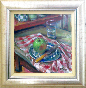 Federation University Art Collection
Painting - Artwork - bookplate, Olley, Margaret, 'Apple with Glass' by Margaret Olley, 2005
Margaret Olley (24 June 1923 – 26 July 2011) Born Lismore, New South Wales In 1941 Margaret commenced classes at Brisbane Central Technical College. In 1943 Olley moved to Sydney and enrolled in an art Diploma course at East Sydney Technical College graduating in 1945 with A-class honours. She is known as a still-life and interior painters Margaret who drew inspiration from her home and studio, and the beauty of the everyday objects she gathered around her. Her paintings often feature arrangements of fruits and flowers, set amid domestic ware art and souvenirs of her travels. For her service as an artist and to the promotion of art, she was awarded the Order of Australia in 1991 and made a Companion of the Order of Australia in 1996. This item is part of the Federation University Art Collection. The Art Collection features over 2000 works and was listed as a 'Ballarat Treasure' in 2007.Framed oil painting of an apple on a table with red gingham cloth. art, artwork, margaret olley, olley, apple, fruit, still life -
 Whitehorse Historical Society Inc.
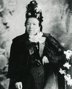
Photograph, Mrs. McGlone
Eliza McGlone was the wife of John McGlone and they were early settlers in Mitcham. They ran one of the earliest hotels in Mitcham: 'The Harvest Home' from 1873. The hotel was conducted in the front room of their house in Whitehorse Road, Mitcham, on the corner of what is now McGlone Street. The hotel closed in 1889. John McGlone died on 3 September 1892 aged 65. Eliza McGlone continued to live in Mitcham until her death on 2 January 1921, aged 85. She had been Mitcham's first official Postmistress and, following several others who had held that position, she returned to that role for a period up to 1914 when Bertha Markham was appointed. The McGlones owned substantial rental properties and had donated one acre in central Mitcham for the Catholic Church. The McGlone Estate was subdivided in 1924, but the name is perpetuated in McGlone Street, Mitcham, near the site of the old Harvest Home Hotel.Black and white photo (three copies of an original taken circa 1890) of Mrs. Eliza McGlone. mcglone, eliza, harvest home hotel, whitehorse road, mitcham, mcglone street -
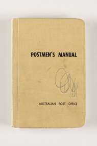 City of Greater Bendigo - Civic Collection
Manual, Post Master General's Department, Postmen's Manual, 1964
When the Commonwealth Post and Telegraph Act was passed in June 1902, and a national Postmaster General's Department (the PMG) was established the responsibility for the nation's mail and telephone services fell on Post Offices. The Bendigo Post Office, built in 1887 and situated on Pall Mall was the central distribution centre for receiving and delivering telegrams and continued to deliver communication and postal services until 1997. Now a Visitor Centre, dedicated volunteers at the Post Office continued to demonstrate and educate the public about the daily workings of the Post Office up until 2019 when Covid 19 disrupted every day life and Ted Rankins, the last Post Master and a long term telegraph volunteer at the Post Office, died. Manuals were issued to postmen to guide them in the delivery of letters and parcels and were small enough to be carried with them. This manual was used by the Bendigo Post Office postmen and is part of the postal collection donated by the Rankins family in memory of Ted Rankins,. Small, creamed coloured cloth covered manual. Contains forty four printed pages and two blank end pages covering all aspects of how to correctly deliver the post. Topics include 'Behaviour', 'Deceased Persons' and 'Bicycles' amongst many others. Book is bound and contains many extra additional paragraphs stuck in on appropriate pages noting changes and amendments. Additional amendments in handwritten red pen also occur on pages 28, 29 and 36.Front cover; Postmen's Manual / Australian Post Office Various annotations and updates throughout. ted rankins collection, bendigo post office, bendigo tourism, city of greater bendigo tourism, post office collection -
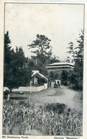 Mt Dandenong & District Historical Society Inc.
Photograph, Mt Dandenong North. Showing "Mountjoy"
The building with the white picket fence is the Beulah Tea Gardens opened by Eliza Hand c1904 at The Gap (now FiveWays). The building is still operating as a cafe. The Tourist Road does not yet exist. Old Coach Road comes into the picture from the right and the horse and cart is heading up Ridge Road. The elm trees can be seen on the left. The building up on the hill is the Mountjoy Guest House. ‘Mountjoy’ was built by the Paynter family in 1905. It had fourteen bedrooms, a dining room and sitting room, kitchen with a big wood burning range and verandahs on three sides. There were commanding views of the eastern ranges and the city to the west. Ellis Jeeves purchased ‘Mountjoy’ in 1908 and it soon became a popular tourist destination, the coach yards making it a centre of the district. ‘Mountjoy’ is a central feature of many photographs of Kalorama in the 1900s. The building burned down in 1975. Mt. Dandenong North was renamed Kalorama in 1926.Black and white postcard showing a horse and cart on road between two buildings.On front ; Mt. Dandenong North. Showing "Mountjoy."postcard, mountjoy, guest house, beulah tea room, beulah, mt dandenong north, kalorama