Showing 22369 items matching "parks"
-
 Eltham District Historical Society Inc
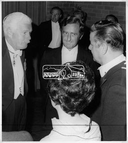
Photograph, Shire of Eltham Centenary Dinner, 6 Apr 1971
His Excellency Major General Sir Rohan Delacombe, Governor of Victoria at the Shire of Eltham Centenary Dinner in 1971 with Cr. G. C. Dreverman, Cr Glover and Mrs Glover. The Premier, Mr Hamer can be seen in the background. The event was held in the West Riding Hall, Petrie Park Community Centre, Montmorency. This photo forms part of a collection of photographs gathered by the Shire of Eltham for their centenary project book, "Pioneers and Painters: 100 years of the Shire of Eltham" by Alan Marshall (1971). The collection of over 500 images is held in partnership between Eltham District Historical Society and Yarra Plenty Regional Library (Eltham Library) and is now formally known as 'The Shire of Eltham Pioneers Photograph Collection.' It is significant in being the first community sourced collection representing the places and people of the Shire's first one hundred years.Digital imagesepp, shire of eltham pioneers photograph collection, shire of eltham, shire of eltham centenary, official dinner, centenary celebrations, cr. g.c. dreverman, sir rohan delacombe, cr. glover, mrs. glover -
 Eltham District Historical Society Inc
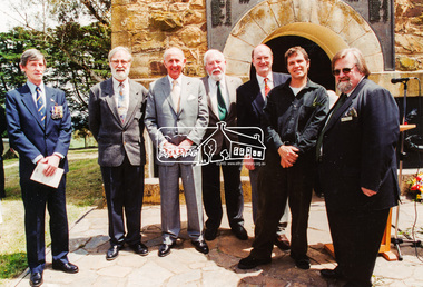
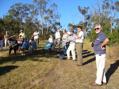
Photograph, The Advisory Committee of the Park and Tower, Rededication Ceremony, War Memorial Tower, Kangaroo Ground. 8 November 2001, 08/11/2001
L-R: Nicholas Pelling, Harry Gillham (Convenor of the Advisory Committee of the Park and Tower), Governor John Landy, Mick Woiwod, Dennis Ward, Dean Stewart, Mayor Cr. Sigmund Jorgensen. (Contained in an album originally put together by Harry Gilham. Photos subsequently relocated to photosafe archival storage.) [2001]Colour photographkangaroo ground, war memorial tower, rededication ceremony, dean stewart, dennis ward, governor of victoria, harry gilham, john landy, mick woiwod, nicholas pelling, sigmund jorgensen -
 Glen Eira Historical Society
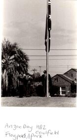
Photograph - ANZAC DAY/REMEMBRANCE DAY
This file contains original photographs of Anzac Day and Remembrance Day Memorial Civic Services from years 1982, 1983, 1984, 1985, 1986. Some of the photos identify location as Caulfield Park. Other photos include persons of interest i.e. Mayor and Mayoress of Caulfield, Members of Parliament and also RSL Presidents.caulfield park, caulfield rsl, mayor, mayoress, town clerk, ford dorothy, patience geoffrey, rudzki brian, campbell jack, campbell a. j., shipton roger, tanner ted, moore hedley, calder graeme, peters austin, walters ron, walters ronald, booth john, rudzki judith, patience jean, loftus elizabeth, hawson robert, conard geoffrey, anzac day, remembrance day, flagpole, wreaths -
 Port Melbourne Historical & Preservation Society
Photograph - Resiting eastern kiosk, Station Pier, Port Melbourne, Ron Laing, 1993
The kiosk was turned sideways to make room for the TT Lines truck park. It was later extended to the east to create a 90 seat restaurant, known at the turn of the century as Cafe Limani. Part of Ron Laing's collection of photographs taken around Port Melbourne over a thirteen year period. Donated to the PMH&PS by the photographer.A set of 18 colour photographs showing the re-siting of the eastern kiosk on Station Pier (later Cafe Limani) c 1993piers and wharves - station pier, ron laing -
 Stratford and District Historical Society
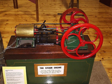
Model Steam Engine
This working-model steam engine was hand-made c.1893 by Frank Scott of Mewburn Park, and used to drive a pump. The entire engine and base were repaired, cleaned and restored by participants in a LEAP program hosted by Eastern Victorian Group Training, Bairnsdale, in June 1995. This included repairing a broken piston arm.This small steam engine has two wheels attached to shafts connected to a single piston. It has a horizontal double-acting three inch bore with a four and half inch stroke fitted with Stephensons link reversing gear. It is mounted on a green-coloured wooden box.engines -
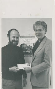 Uniting Church Archives - Synod of Victoria
Photograph, 1987
Reverend John Hill was ordained in 1969 who served at Myrtleford, Wattle Park, Mitchell Presbytery, Stawell, Commission for Mission, United States, and Bendigo West Reverend Robert Mackay Cross served in Shepparton North, Chaplain of Queen Elizabeth Geriatic Centre Ballarat, Chairman and Executive Secretary of the Division of Community Services.B & W photograph showing Reverend Cross presenting a cheque to Reverend John Hill, minister at Stawell and chairman on state recovery committee for disaster relief."Rev John Hill (right) Rev Robert Cross (left) C&N 22/7/1987 page 29"hill, john, cross, robert -
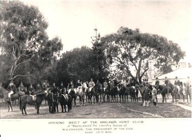 Hume City Civic Collection
Photograph, 17 May 1890
The photograph was taken by Paul and Gerald Turner, formerly of Fitzroy Street, St. Kilda. It was taken to record the opening meeting of the 1890 season on 17 May. Members met at 'Woodlands', the country house of W. H. Crocker, who was the club president. The photo was supplied courtesy of Oaklands Hunt Club and the National Parks Service.A black and white photograph of the opening of the Oaklands Hunt Club. Most of the riders are mounted on horses which are standing in front of the picket fence, in a semi-circle. Four other men are standing in the foreground.OPENING MEET OF THE OAKLANDS HUNT / at 'WOODLANDS' the country house of / W.H. CROCKER, THE PRESIDENT OF THE CLUB / MAY 17th 1890oaklands hunt club, national parks, house names, horses, 1890s, crocker, w. h., turner, paul, gerald, photographers, woodlands, men, clothing and dress, george evans collection -
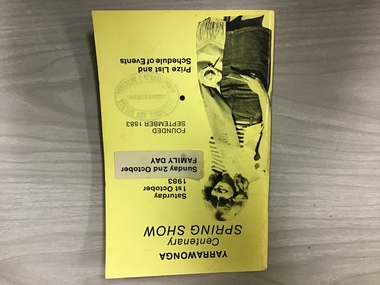 Yarrawonga and Mulwala Pioneer Museum
Show schedule, Yarrawonga Centenary Spring Show, Saturday October 1st, 1983, 1983
The first show was held inSept 1883 at Alexander Park on the Murray River. Two years later it was moved to the Showgrounds south of the town. Two shows have been missed, one due to WW2 and the other due to drought and a poor season. The Centenary Show was held over two days with a street parade on the Sunday.A5 size booklet Yellow card cover. Newspaper quality pages. Lists committee members,Life members, Stewards,prizes, classes and events -
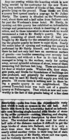 Ballarat Heritage Services
Newspaper - Newspaper article, Newsclipping Relating to Stonemason Julien Hardy
Julien Hardy was the first discoverer of gold at Happy Valley. A stonemason, he was born at Vire, Normandy, France. He established a stone quarry on the Melbourne Road, near Warrenheip (on the site now occupied by Shady Acres Caravan Park). From here, he quarried blocks that were used in the Ballarat Town Hall.Newsclippingjulien hardy, stonemason, gold, happy valley, shady acres, warrenheip, ballarat town hall -
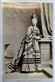 Kew Historical Society Inc
Photograph - Miss Louisa Henty, c.1875
Louisa Henty (1847-24) was the eldest daughter of Francis and Mary Ann Henty (nee Lawrence). Following the deaths of her mother and father, she inherited 'Fieldplace' in Studley Park, Kew, and 'Merino Downs' in Henty, near Casterton. The original photo, owned by a descendant of Francis Henty is part of an album of family photographs.Print copy of an original carte de visite; a studio portrait of Miss Louisa Henty, daughter of Francis and Mary Ann Henty (nee Lawrence). Photographed in the Johnstone & O'Shannessy & Co atelier, she is posed in a day dress which has a polonaise and train, dating the photograph to the mid 1870s. Standard props used by the studio include imitation masonry and a curtain.Front: "Johnstone & O'Shannessy & Co"louisa henty, henty family, merino downs, fieldplace -- kew (vic) -
 Kew Historical Society Inc
Photograph - Corner of Normanby and Parkhill Roads, Kew, 1926
The section of Normanby Road, Kew from Cotham Road to Parkhill Road was officially gazetted in 1865. The part of Normanby Road between Parkhill Road and Harp Road was gazetted ten years later in 1875. Parkhill (sometimes Park Hill) Road East and Parkhill Road West were both gazetted in 1865.Original, black and white positive print of a photograph taken from a house in Normanby Road across the road to another house on the corner of Normanby and Parkhill Roads. The hills of Kew can be seen in the background. The main house in the photo is 57 Normanby Road.Inscribed verso: "Normanby Rds and Parkhill Rds corner " normanby road -- kew (vic.), parkhill road -- kew (vic.), 57 normanby road -- kew (vic.) -
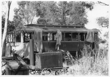 Ballarat Tramway Museum
Photograph - Tram 32 Maryborough Park, late 1972
The photograph shows SEC Ballarat tram Nos. 32 on-site at the proposed Maryborough Chamber of Commerce "Wildlife" park. This did not proceed. The photo is most likely taken before a roof was placed over the tram. The date and Photographer are unknown. See item 6604 and 6632 for other photos. The tram was acquired by the BTPS in 1986.Yields information about tram 32 at the proposed Wildlife page.Black and White print on plain paper.tramcars, tram 32, maryborough, transporting trams -
Whitehorse Historical Society Inc.
Map, Yarran Dheran Charts, 1974
Charts relating to the formation of Yarran DheranRolled charts of various dimensionsnon-fictionCharts relating to the formation of Yarran Dheranyarran dheran, yarran dheran advisory committee, thompson paul -
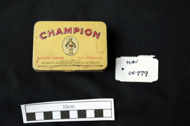 City of Moorabbin Historical Society (Operating the Box Cottage Museum)
Containers, tin, Tobacco ‘Champion’, c1940
W.D & H.O.Wills (Australia) Ltd began manufacturing tobacco products in 1913 at its Raleigh Park factory in Kensington, Sydney. In 1945 an estate of 16 acres was purchased at East Bentleigh, Melbourne, with a further 22 acres purchased later and the Virginia Park manufacturing branch was established. The 1950s were to be one of the most successful decades in the company’s history and it enjoyed a peak of 83 per cent market share in 1954. But this was also a period of increased competition as Phillip Morris and Rothmans entered the Australian tobacco market. By 1972, increased competition meant that the company’s market share had slipped to 39%. By the time tobacco advertising was banned on Australian radio and television in 1976, Wills' market share had fallen a further 6%. In 1985 Wills combined the separate factory operations in Sydney and in Melbourne into one site at Pagewood, Sydney which took on the name Virginia Park. In 1989 W.D & H.O.Wills (Australia) became a subsidiary of the British American Tobacco Industries group of companies. 1999 British American Tobacco merged with global competitor Rothmans International. Rothmans in Australia and Wills merged to form the wholly-owned subsidiary British American Tobacco Australia. The merger left British American Tobacco Australia, Phillip Morris and Imperial Tobacco Australia A tin with a hinged lid for 'Champion' Tobacco flakesCHAMPION / HIGHEST GRADE / CUT TOBACCO / MANUFACTURED BY / THE BRITISH AUSTRALIAN TOBACCO CO.PTY.LTDtobacco, cigarettes, brittish australian tobacco co. pty. ltd., moorabbin, bentleigh, cheltenham, early settlers, , wd &h.o.wills pty. ltd., east bentleigh, kensington , virginia park east bentleigh, champion flake tobacco -
 Wooragee Landcare Group
Photograph, circa April 2003
This photograph was taken in the Mount Pilot Chiltern National Park. This park is located near Chiltern in Victoria. It's most notable landmarks include Mt Pilot and Woolshed Falls. It also has many mines from the Gold Rush in the late 1800s. It is home to much flora and fauna, including the tiger quoll. The tiger quoll, also known as the spotted-tail quoll, is a marsupial that gives in the Mount Pilot Chiltern National Park. It is also main land Australia's largest carnivorous marsupial. It can weigh up too four kilograms and looks similar to either a possum or a spotted cat. It has red and brown fur with distinct spots. The tiger quoll is found along the Great Dividing Range, which includes Victoria, New South Wales and also near the border of Queensland. It lives in forests, rainforests and coastal heathlands and woodlands. In 2004 a team of volunteers from the Wooragee Landcare group as well as some of the Department of Sustainability and Environment staff set out to find the tiger quoll following the 2003 bushfires. Since the bushfires, concern had arisen for it because it hadn't been seen since the bushfires. They attempted to find traces of the quoll through finding and identifying their droppings as well as DNA testing. This photograph was taken during this search. This photograph represents the work that goes into protecting a important species like the tiger quoll. The tiger quoll is a significant species because it is main land Australia's largest carnivorous marsupial. As a result of this, there has been much work done to preserve and protect it. This photograph was taken when the Wooragee Landcare group went to ensure the survival of this species, highlighting how the tiger quoll is being protected. This photograph also demonstrates the impacts of the 2003 bushfires in the Mount Pilot Chiltern National Park. This is seen through the burnt trees featured in the picture. Landscape coloured photograph printed on gloss paperReverse: WAN NA 0ANA0N0 NNN 0 1636 / [PRINTED] (No.7) / 921quoll, mount pilot chiltern national park, national park, 2003 bushfires, search, endangered, beechworth, wooragee landcare group, wooragee landcare, wooragee, possum, australia, victoria, department of sustainability and environment, photograph, 2004, spotted-tailed quoll, great dividing range, spots, fur, forests, rainforests, woodlands, coastal heathlands, spotted quoll, spotted quoll habitat -
 Bendigo Historical Society Inc.
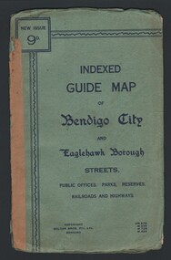
Map - INDEXED GUIDE MAP OF BENDIGO CITY & EAGLEHAWK BOROUGH, Early to mid 1920's
Map. Indexed Guide Map of Bendigo City & Eaglehawk Borough. Folded map contained within blue booklet. Booklet is light blue printed with dark blue ink. Copyright Bolton Bros. Pty. Ltd. Bendigo. Printed on front. Map shows the location of Sailors Gully, Peg Leg Gully, California Gully, Long Gully, Eaglehawk Creek, Bendigo Creek, Ironbark Creek. Shows location of Showgrounds between Park St, Baxter Street, Barnard St and Bridge Lane. Shows location of Golden Square Railway Station between Panton St and Allingham St. Shows what is now known as Creek St. Nth & Sth as Clark St Nth & Sth. Also shows Tramway Terminus along Carpenter St and Golden Square Tram Terminus on High St, Golden Square. Map has a street index and an index for Public Offices, Parks and Reserves.map, bendigo, township, indexed guide map of bendigo city and eaglehawk borough -
 Bendigo Historical Society Inc.
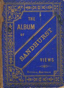
Book - MERLE HALL COLLECTION: THE ALBUM OF SANDHURST VIEWS
A bound book of 16 drawings B&W (lithographs?) in ''photographic'' detail of well-known Sandhurst Views - Town Hall, Mechanics Institute, Masonic Hall, Bendigo Hospital, Bendigo Benevolent Asylum, Post and Telegraph Offices, Mining Exchange, View from Post Office Tower looking East, View from Post Office Tower looking West, Central State School, Alexandra Fountain, Upper Lake,Rosalind Park, Fernery Rosalind Park, St Pauls Church, Bishop's Palace, General View - New Chum Line, Koch's ''Pioneer'' Crushing Works, Quartz Crushing batteries, Town Hall - Eaglehawk, Railway Station. Appended with two pages summarizing Sandhurst history; current councillors and officers, brief review of five places - Bendigo Hospital, Benevolent Asylum, Mechanics Institute and Free Library, School of Mines and Industries, Masonic Hall. Date is given as ''The present (1888) occupants are ....'' -
 Kew Historical Society Inc
Plan - Subdivision Plan, J R Mathers & McMillan, Clutha Subdivision, 1940
Pru Sanderson, in her groundbreaking ‘City of Kew Urban Conservation Study : Volume 2 - Development History’ (1988), summarised the periods of urban development and subdivisions of land in Kew. The periods that she identified included 1845-1880, 1880-1893, 1893-1921, 1921-1933, 1933-1943, and Post-War Development. These periods were selected as they represented periods of rapid growth or decline in urban development. An obvious starting point for Sanderson’s groupings involved population growth and the associated economic cycles. These cycles also highlighted urban expansion onto land that was predominantly rural, although in other cases it represented the decline and breakup of large estates. A number of the plans in the Kew Historical Society’s collection can also be found in other collections, such as those of the State Library of Victoria and the Boroondara Library Service. A number are however unique to the collection.The Kew Historical Society collection includes almost 100 subdivision plans pertaining to suburbs of the City of Melbourne. Most of these are of Kew, Kew East or Studley Park, although a smaller number are plans of Camberwell, Deepdene, Balwyn and Hawthorn. It is believed that the majority of the plans were gifted to the Society by persons connected with the real estate firm - J. R. Mathers and McMillan, 136 Cotham Road, Kew. The Plans in the collection are rarely in pristine form, being working plans on which the agent would write notes and record lots sold and the prices of these. The subdivision plans are historically significant examples of the growth of urban Melbourne from the beginning of the 20th Century up until the 1980s. A number of the plans are double-sided and often include a photograph on the reverse. A number of the latter are by noted photographers such as J.E. Barnes.The subdivision plan for the Clutha Subdivision is one of the largest in the Society’s collection. The plan includes a map of the proposed allotments, photographic views to the north and south, and information about the kinds of buildings that could be constructed on the allotments. The subdivision was bounded by Studley Park Road, and Carson, Stevenson and Edgecombe Streets. Two new streets, Mackie Court and Younger Street were created as part of the subdivision. The subdivision took its name from ‘Clutha’, the home of John Carson, who was to become Mayor of Kew in 1863. A Report to the City of Boroondara outlined how: ‘The Clutha estate was progressively developed from 1940, with new houses under construction on the Studley Park Road, Carson and Edgecombe Street frontages by 1941. By 1943, directory listings were available for all addresses with the exception of Mackie Court. Building ceased after the government’s prohibition on civilian building was enforced from 1942, with little change in listings until the 1950s when the remainder of the subdivision was developed’."H"subdivisions - kew - studley park, clutha subdivision, studley park road -
 Ballarat Tramway Museum
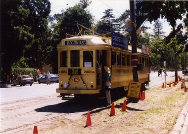
Photograph - Colour Photograph/s set of 6, Carolyn Dean, 10/03/2001 12:00:00 AM
Set of six photographs taken by Carolyn Dean on 10.03.2001 of operations in Wendouree Parade during the 2001 Begonia Festival. Printed on Kodak paper. 1786.1 - Gold tram 45 - at Gardens Loop, heading south, with destination "Begonias". Has witches hats and special stop boards in view. Also advertising Ballarat Eureka and Sovereign Hill. .2 - Tram 33 - south bound at Depot Junction with Peter Winspur talking to crew. Has Ice Cream Man van in background. .3 - Gold tram 45 at Depot Junction, southbound, showing destination "Car Park" with Dave Macartney in view and another crew member (Phillip Bertram) in uniform holding the megaphone. .4 - Tram 33, showing "Depot" near Depot Junction, running northbound. .5 - Gold tram 45, at same location, showing "Car Park", northbound and Bendigo Cafe tram advertising board. .6 - as for .3, with Phillip Bertram in photo holding megaphoneAll have date "10.03.01" and "Photo Carolyn Dean" written on the back in blue ink.begonia festival, gold tram, depot junction, gardens loop, wendouree parade, btm, tram 45, tram 33 -
 Camperdown & District Historical Society
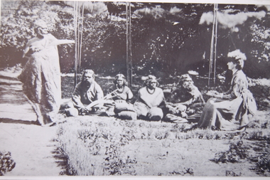
Photograph - Isabella Dawson with First Nations informants, c1865
Isabella Park Taylor, nee Dawson (1842-1929), friend of Western Victorian First Nations people, and student of their languages and customs. Isabella grew up at "Kangatong" (1844-1866) in the company of First Nations people and became fluent in their languages. With her father, James Dawson, she wrote the book "Australian Aborigines" (1881). Black and white photograph taken at "Kangatong", near Hawkesdale showing group of First Nations people in conversation with Isabella Dawson, seated on right with notebook in hand. Standing at left is Kaawirn Kuunawarn (also know as Hissing Swan and King David).James Dawson's daughter, Isabella, learning from the Aborigines on her father's station at "Kangatong" (From the original belonging to Miss M. Turner Shaw of S. Yarra. Copied by A.E. Jackson of Timboon.)cdhs, miss mary turner shaw, kaawirn kuunawarn, hissing swan, cdhsfirstnations -
 Camperdown & District Historical Society
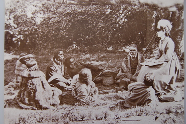
Photograph - Western District First Nations people with Isabella Dawson at 'Kangatong', c1865
Isabella Park Taylor, nee Dawson (1842-1929), friend of Western Victorian First Nations people, and student of their languages and customs. Isabella grew up at "Kangatong" (1844-1866) in the company of First Nations people and became fluent in their languages. With her father, James Dawson, she wrote the book "Australian Aborigines" (1881).Black and white photograph taken at "Kangatong", near Hawkesdale, of seven Western Victorian First Nations people all seated in conversation with Isabella Dawson, seated at right with notebook and pen in hand.cdhs, cdhsfirstnations -
 Warrnambool and District Historical Society Inc.
Ephemera - Badge, Warrnambool High School, c 1980
This is a Warrnambool High School badge . Warrnambool High School was established in 1907 and was housed in various locations around Warrnambool until 1961 when it moved into a purpose built building in Albert Park, Warrnambool . It merged with Warrnambool North Technical School to become Warrnambool College.in 1994..The badge is of superior quality and was probably given to visitors.This is retained as a memento of Warrnambool High School which was established over 100 years ago. A circular metal badge with gilt edging and the school emblem in black and gold on a green background.There is a stud clip at the back.and a a fob chain attached. WHS Nil Sine Labore Taiwan warrnambool high school, warrnambool, badge -
 Port of Echuca
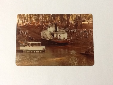
Colour Photograph, 04/03/1983
Colour photograph of P. S. Adelaide being encouraged down the soil ramp at Paddlewheel Park, onto the Murray river at Echuca. An outboard float is on the left with some spectators on it. Spectators line both sides of the ramp. Some kind of winching float is on the right. Part of photo sequence no. P000041; P000045; P000046; P000047; P000048.The re-floating of the P. S. Adelaide was a significant community social event evident by the number of spectators in the photograph. The community had invested a great deal of time and money into re-floating the paddlesteamer. The newspaper covered the event in detail with a number of action shots as the boat made its rear entry onto the Murray river.Colour photograph of P. S. Adelaide being encouraged down a soil ramp onto the river. An outboard float is on its left. Spectators line both sides of the ramp. Some kind of winching float is on the right.p. s. adelaide, echuca, re-floating p. s. adelaide -
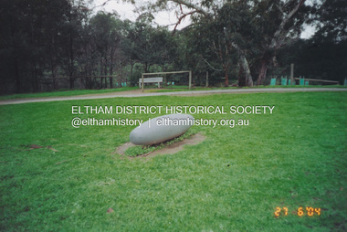 Eltham District Historical Society Inc
Photograph, Fay Bridge, Not Just a Pretty Place, Aleks Danko (2000), Lennister Farm, Eltham South, 27 June 2004
Not Just a Pretty Place, Aleks Danko (2000), Lennister Farm, Eltham South, c.2001 The sculpture was launched on 9th August 2000 by Cr Diane Bullen and welcomed by Annette Xiberras of the Wurundjeri community. Awarded the 2000 Nillumbik Art in Public Places Award and situated behind Lennister Farm near Yarra Parkfay bridge collection, 2004-06-27, aleks danko, art in public places, eltham south, lennister farm, not just a pretty place, public art -
 Greensborough Historical Society
Book, Nillumbik Shire Council, 1997 Community Guide Nillumbik, 1997_
Guide to services provided by Nillumbik Shire Council. Nillumbik Shire is located 25 kilometres north-east of Melbourne and the southern boundary is the Yarra River. The south of Nillumbik is predominantly urban, with commercial centres at Eltham and Diamond Creek. The north of the municipality includes significant natural features like Kinglake National Park and Sugarloaf ReservoirAnnual guide to services in Nillumbik. 64 pages. Cover is pale yellow with colour drawings. nillumbik shire council, handbooks -
 Greensborough Historical Society
Book, Nillumbik Shire Council, 1998 Community Guide Nillumbik, 1998_
Guide to services provided by Nillumbik Shire Council. Nillumbik Shire is located 25 kilometres north-east of Melbourne and the southern boundary is the Yarra River. The south of Nillumbik is predominantly urban, with commercial centres at Eltham and Diamond Creek. The north of the municipality includes significant natural features like Kinglake National Park and Sugarloaf ReservoirAnnual guide to services in Nillumbik 72 pages. Cover has white background and some 3-D artwork.nillumbik shire council, handbooks -
 Greensborough Historical Society
Book, Nillumbik Shire Council, 1999 Community Guide Nillumbik, 1999_
Guide to services provided by Nillumbik Shire Council. Nillumbik Shire is located 25 kilometres north-east of Melbourne and the southern boundary is the Yarra River. The south of Nillumbik is predominantly urban, with commercial centres at Eltham and Diamond Creek. The north of the municipality includes significant natural features like Kinglake National Park and Sugarloaf ReservoirAnnual guide to services in Nillumbik76 pages, illus. Cover has photographs of local people and title in white on orange background.nillumbik shire council, handbooks -
 Greensborough Historical Society
Book, Nillumbik Shire Council, Nillumbik Community Guide 2000/2001, 2000-2001
Guide to services provided by Nillumbik Shire Council. Nillumbik Shire is located 25 kilometres north-east of Melbourne and the southern boundary is the Yarra River. The south of Nillumbik is predominantly urban, with commercial centres at Eltham and Diamond Creek. The north of the municipality includes significant natural features like Kinglake National Park and Sugarloaf ReservoirAnnual guide to services in Nillumbik76 pages, black and white illustrations. Cover has a collage of local children with title in white on mid-blue background.nillumbik shire council, handbooks -
 Greensborough Historical Society
Photograph - Digital image, Happy Hollow plaque unveiling 1 and 2, 24/10/2006
Photograph of descendants of past owners of Happy Hollow preparing to unveil the commemorative plaque. Includes descendants of Charles Partington, John McLaughlin and Robert Emmett Whatmough. The land was later owned by Mrs Betty Bell and was purchased by Parks Victoria in 1994 to form part of the Plenty Gorge Parklands. This plaque was laid by Plenty Historical Society. Digital copy of colour photograph.happy hollow, robert emmett whatmough, charles partington, betty bell, parks victoria -
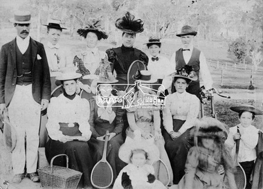 Eltham District Historical Society Inc
Photograph, Eltham tennis group
A group of nine women and two men (one holding a bike) and two children pose for a group photograph, some of whom are sitting. Five people hold tennis racquets and there is a picnic basket in the foreground. There are trees in the background. This group may or not be related to photos of the Eltham tennis courts located in what is now known as Wingrove Park.This photo forms part of a collection of photographs gathered by the Shire of Eltham for their centenary project book,"Pioneers and Painters: 100 years of the Shire of Eltham" by Alan Marshall (1971). The collection of over 500 images is held in partnership between Eltham District Historical Society and Yarra Plenty Regional Library (Eltham Library) and is now formally known as the 'The Shire of Eltham Pioneers Photograph Collection.' It is significant in being the first community sourced collection representing the places and people of the Shire's first one hundred years.Digital imagesepp, shire of eltham pioneers photograph collection, eltham, tennis, tennis players, wingrove park