Showing 8467 items matching " 20"
-
 Greensborough Historical Society
Report, Examining Draughtsman's Report - Watts River Aqueduct, 20/07/1897
This Field Survey was commissioned by the Melbourne Board of Works and was used to position the Maroondah Aqueduct bridge north of Greensborough at its crossing point on the Plenty River. It incorporated the use of wrought iron water pipes and therefore is of lighter construction than other similar bridges in the district. It features a traverse of the Plenty RiverThe Maroondah Aqueduct bridge is a significant example of late 19th century engineering. A 4 page reproduction of an Office of Titles document. Copy of handwritten report includes maps.maroondah aqueduct, watts river aqueduct, bridge, greensborough, office of titles, 1897, wrought iron water pipes, plenty river, melbourne board of works -
 Heathcote McIvor Historical Society
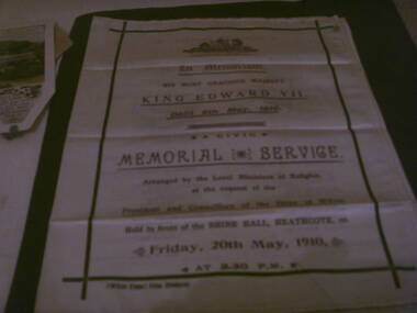
Memorial booklet, shire of mcivor, minsiters of religion, Silk Memorial Booklet Death of King Edward VII 6 May 1910, 06/05/1910-20/05/1910
Created for the memorial service that was held on friday 20th may 1910, held in front of the shire hall in Heathcote to honour king edward VII who died on the 6th may 1910 at 2.30 p.m. this was arranged by the local ministers of religion at the request of the president and councillers of the shire of McIvor.Believed to be the only one in exsistence, after intesive research have been unable to come up with any information, from the shire, local churches or senior members of the community,only mention was in the Bendigo Advertiser newspaper.research in to archives further afield have not produced another.Piece of cream silk printed on face and inside, screen printed in purple and black ink on front and inside the order of service. details of all ministers of religion and shire dignitries as well as hyms sung. "McIvor Times" Print, Heathcote on left hand side below main print. in black inkvictoria, silk memorial booklet, king edward vii, 1910, heathcote, ministers, of, local, churches, shire, president, mcivor, times -
 4th/19th Prince of Wales's Light Horse Regiment Unit History Room
Document, Artillery Training Vol III Pam No 2 Part 1 1942 Amendment No 1, 20 November 1943
Amendment Noticeartillery training, world war 2 -
4th/19th Prince of Wales's Light Horse Regiment Unit History Room
Document, Robert Bruce, The Lewis Gun (Product Information), 20/10/2002
A five page article about the history, manufacture and use of the Lewis Machine Gun reproduced from Find articles.com , written by Robert Brucelewis gun -
Yendon History Group
Book, school mothers' minutes, Invicta, School Mothers' Club Meetings Minutes Book, 1962 (estimated); First entry is 20/2/1963
High level of local significance as book contains factual insight into school matters.Minutes book from meetings of the school's mother's club"INVICTA" logo on the front cover. All hand-written entries.yendon state school, mother s club meeting minutes -
 Eltham District Historical Society Inc
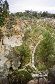
Photograph, Balaclava Open Cut Mine near Whroo Historic Reserve; 9 Oct 1994, 20/11/1994
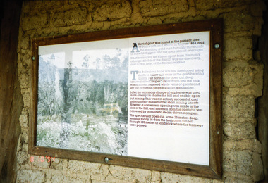
Whroo Historic Reserve contains a number of interesting features relating to the former township and gold workings.Record of the Society's history of activities - Spring 1994 excursionRoll of 35mm colour negative film, 4 stripsKodak Gold 100-4shire of eltham historical society, activities, whroo, balaclava hill, balaclava mine, gold mining, whroo historic reserve -
 Eltham District Historical Society Inc
Photograph, Balaclava Open Cut Mine near Whroo Historic Reserve; 9 Oct 1994, 20/11/1994
Whroo Historic Reserve contains a number of interesting features relating to the former township and gold workings.Record of the Society's history of activities - Spring 1994 excursionRoll of 35mm colour negative film, 4 stripsKodak Gold 100-4shire of eltham historical society, activities, whroo, balaclava hill, balaclava mine, gold mining, whroo historic reserve -
 Eltham District Historical Society Inc
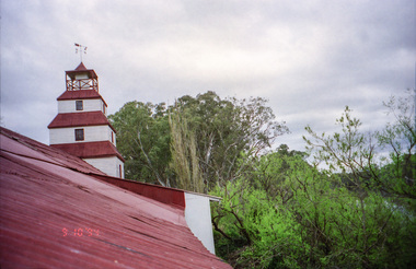
Photograph, Whroo Historical Area; 9 Oct 1994, 20/11/1994
Whroo Historic Reserve contains a number of interesting features relating to the former township and gold workings.Record of the Society's history of activities - Spring 1994 excursionRoll of 35mm colour negative film, 4 stripsKodak Gold 100-4shire of eltham historical society, activities, whroo, balaclava hill, balaclava mine, gold mining, whroo historic reserve -
 Eltham District Historical Society Inc
Photograph, Whroo Historical Area; 9 Oct 1994, 20/11/1994
Whroo Historic Reserve contains a number of interesting features relating to the former township and gold workings.Record of the Society's history of activities - Spring 1994 excursionRoll of 35mm colour negative film, 4 stripsKodak Gold 100-4shire of eltham historical society, activities, whroo, balaclava hill, balaclava mine, gold mining, whroo historic reserve -
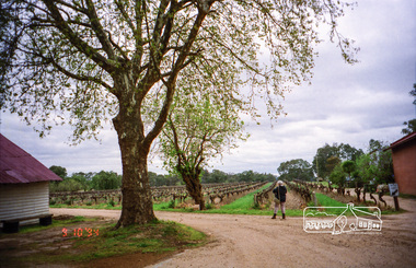
 Eltham District Historical Society Inc
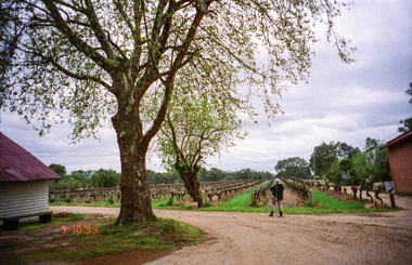
Photograph, Chateau Tahbilk Winery; 9 Oct 1994, 20/11/1994
Brief visit of the Major Mitchell Trail. This car based trail follows the route of the famous explorer right across Victoria. It crosses the Goulbum River near Chateau Tahbilk and Mitchelton Wineries and passes through Nagambie.Record of the Society's history of activities - Spring 1994 excursionRoll of 35mm colour negative film, 4 stripsKodak Gold 100-4shire of eltham historical society, activities, chateau tahbilk winery, major mitchell trail -
 Eltham District Historical Society Inc
Photograph, Balaclava Open Cut Mine near Whroo Historic Reserve; 9 Oct 1994, 20/11/1994
Whroo Historic Reserve contains a number of interesting features relating to the former township and gold workings.Record of the Society's history of activities - Spring 1994 excursionRoll of 35mm colour negative film, 4 stripsKodak Gold 100-4shire of eltham historical society, activities, whroo, balaclava hill, balaclava mine, gold mining, whroo historic reserve -
 Eltham District Historical Society Inc
Photograph, Whroo Historical Area; 9 Oct 1994, 20/11/1994
Whroo Historic Reserve contains a number of interesting features relating to the former township and gold workings.Record of the Society's history of activities - Spring 1994 excursionRoll of 35mm colour negative film, 4 stripsKodak Gold 100-4shire of eltham historical society, activities, whroo, balaclava hill, balaclava mine, gold mining, whroo historic reserve -
 Eltham District Historical Society Inc
Photograph, Chateau Tahbilk Winery; 9 Oct 1994, 20/11/1994
Brief visit of the Major Mitchell Trail. This car based trail follows the route of the famous explorer right across Victoria. It crosses the Goulbum River near Chateau Tahbilk and Mitchelton Wineries and passes through Nagambie.Record of the Society's history of activities - Spring 1994 excursionRoll of 35mm colour negative film, 4 stripsKodak Gold 100-4shire of eltham historical society, activities, chateau tahbilk winery, major mitchell trail -
 Eltham District Historical Society Inc
Photograph, Liz Pidgeon, Heritage Excursion; East of Eltham, 6 Sep 2014, 20 May 2017
Newsletter No. 218, September 2014 September Excursion - East of Eltham Walk In Newsletter No. 197, March 2011, there was a brief history of Crown Allotment 15 Section 5 Parish of Nillumbik (CA 15) a parcel of land of a quarter of a square mile extending from Eucalyptus Road to Reynolds Road at the eastern extremity of Eltham. From the 1940s it was known as Stokes orchard. In later years it has been subdivided for residential purposes but leaving significant areas as power line and water supply reserves and bushland reserves that are habitat for the threatened For our excursion on 6th September we intend to walk through CA 15 to a bushland reserve east of Reynolds Road. The walk will traverse the boundary between suburban Eltham and the non-urban areas to the south and east. This is a pleasant walk through residential areas and bushland. Along the way we will discuss the early and more recent history of CA 15 as well as local natural history and geology. This walk is about 3.5 km in length and will take 2 to 2.5 hours. It will start at 2pm at the corner of Eucalyptus Road, Pitt Street and Nyora Road.Born Digitaleltham east, eltham district historical society, heritage excursion, activities, nyora road, reynolds road, gum tree road reserve, diosma road, stokes orchard, eucalyptus road -
 Eltham District Historical Society Inc
Photograph, Liz Pidgeon, Heritage Excursion; East of Eltham, 6 Sep 2014, 20 May 2017
Newsletter No. 218, September 2014 September Excursion - East of Eltham Walk In Newsletter No. 197, March 2011, there was a brief history of Crown Allotment 15 Section 5 Parish of Nillumbik (CA 15) a parcel of land of a quarter of a square mile extending from Eucalyptus Road to Reynolds Road at the eastern extremity of Eltham. From the 1940s it was known as Stokes orchard. In later years it has been subdivided for residential purposes but leaving significant areas as power line and water supply reserves and bushland reserves that are habitat for the threatened For our excursion on 6th September we intend to walk through CA 15 to a bushland reserve east of Reynolds Road. The walk will traverse the boundary between suburban Eltham and the non-urban areas to the south and east. This is a pleasant walk through residential areas and bushland. Along the way we will discuss the early and more recent history of CA 15 as well as local natural history and geology. This walk is about 3.5 km in length and will take 2 to 2.5 hours. It will start at 2pm at the corner of Eucalyptus Road, Pitt Street and Nyora Road.Born Digitaleltham east, eltham district historical society, heritage excursion, activities, nyora road, reynolds road, gum tree road reserve, diosma road, stokes orchard, eucalyptus road