Showing 8870 items matching " construction"
-
 Eltham District Historical Society Inc
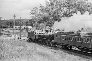
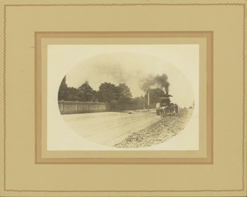
Photograph, Steam locomotive D-639 Vintage train excursion bound for Eltham at the Wattletree Road level crossing, Eltham, c.1970, 1970
Possibly run in conjunction with the Eltham Community Festival or the Hurstbridge Wattle Festival; the steam train would conduct trips between Eltham and Hurstbridge Railway stations. As there is no turning table at Hurstbridge, the locomotive would simply shunt from one end of the carriages to the other to reverse direction, hence the locomotive is running in reverse as it approaches Eltham Station. The first house in the background on Railway Parade, Number 97, remains as of 2019. The next house, Number 95 has been demolised since April 2018 and new construction in place.Digital TIFF file Scan of 35mm Ilford HP4 black and white transparencyd-639, eltham festival, george coop collection, hurstbridge wattle festival, level crossing, passenger carriage 19bc, railway parade, steam engine, vintage train excursion, wattletree road -
 Eltham District Historical Society Inc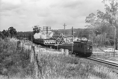
Photograph, A walk through the cemetery at Kangaroo Ground, Diana Bassett-Smith, 1 October 2001, 2001
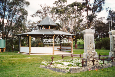
The Kangaroo Ground Cemetery celebrated its 150th anniversary in 2001. Celebrations included the opening of a new rotunda on the 26 October 2001. This photo is a part of a brief collection of reminiscences by Diana Bassett-Smith of locals who are buried at Kangaroo Ground Cemetery along with 17 photographs following a visit on 1 October 2001. "We wanted to see how the construction of a rotunda at the cemetery was progressing and were surprised and pleased to see it finished. A new green plastic water tank was atop a stand not far away." Colour photograph printkangaroo ground cemetery, rotunda -
 Eltham District Historical Society Inc
Photograph, A walk through the cemetery at Kangaroo Ground, Diana Bassett-Smith, 1 October 2001, 2001
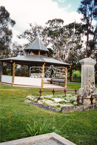
The Kangaroo Ground Cemetery celebrated its 150th anniversary in 2001. Celebrations included the opening of a new rotunda on the 26 October 2001. Ths photo is a part of a brief collection of reminiscences by Diana Bassett-Smith of locals who are buried at Kangaroo Ground Cemetery along with 17 photographs following a visit on 1 October 2001. "We wanted to see how the construction of a rotunda at the cemetery was progressing and were surprised and pleased to see it finished. A new green plastic water tank was atop a stand not far away." Colour photograph printkangaroo ground cemetery, rotunda -
 Glenelg Shire Council Cultural Collection
Souvenir - Souvenir Glass, n.d
STS Young Endeavour is a brigantine rigged tall ship, purpose built for sail training as a bicentenary gift from the Government and the people of the United Kingdom to the people of Australia. Construction began in May 1986 in Lowestoft, England and on 3 August, 1987 the ship began the voyage to Australia with a crew of 12 young people from Great Britain and 12 young Australians. The official handover ceremony took place on 25 January, 1988 in the presence of their Royal Highnesses the Prince and Princess of Wales in Farm Cove, Sydney Harbour.Glass, commemorating the visit of the Young Endeavour. Gold rim, gold embossed depiction of Young Endeavour.Front: 'Young Endeavour visits Robe December 1987' - gold embossed Back: 'To commemorate the visit of Young Endeavour Britain's Official Bicentennial gift to Australia 1988' - gold embossedyoung endeavour, ship, tall ships, bicentenary -
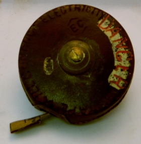 Kiewa Valley Historical Society
Tape Measure 33ft, Early to mid 1900's
This flexible measuring tape was used by the SEC Victoria in the mid to late 1900's. It was in a period before digital measuring instruments were in use. This is a 33ft long tape measure and would have been used by the construction workers when building the Kiewa Valley Hydro System. The warning details (embossed into the leather covering) was to warn users to be careful not to use the tape near live electricity terminals or linkages. This tape was produced mainly for wooden structures and not electricity conductive material. This was during the 1950's to 1960's.This imperial tape measure is very significant to the Kiewa Valley as it was used in the construction of the Kiewa Valley Hydro Scheme of the 1950's-1960's. It provides evidence that small measuring equipment used in the construction and the continuing maintenance of the scheme was of the imperial measure and used by construction workers who remained and settled in the town of Mount Beauty and Kiewa Valley long after the construction period. This flexible metallic measuring tape (33 ft in length) is contained in a round circular leather bound container. It has brass fittings (winder and tape guide) and is stitched with heavy grade twine. The tape measure is graduated in feet and inches on one side and yards on the other. Embossed in the leather casing"MADE IN ENGLAND" and around the inner circle "HOCKLEY ABBEY" and "JOHN RABONE & SONS"imperial tape measure, distance measures, imperial tools -
 Eltham District Historical Society Inc
Photograph, Ruth H. Pendavingh, Reconstruction of Main Road from Main Road Bridge to Mount Pleasant Road, Eltham, 1984
The original timber bridge over the Diamond Creek was built around 1840. It was destroyed by floodwaters in October 1923. A temporary bridge was rigged up but further damaged in April 1924. A new concrete bridge was built and opened in October 1926. The bridge decking was widened along with Main Road to Dalton Street by the Road Construction Authority in 1984. The upgraded bridge was re-opened October 25, 1984, 78 years after its original opening. (EDHS Chronology of known local events 1835- early 2000)Three colour photograph prints 1984, bridge construction, diamond creek (creek), eltham south, main road, main road bridge, road construction -
 Federation University Historical Collection
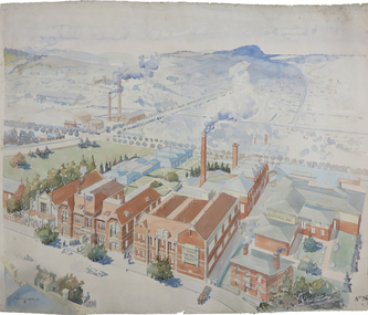
Painting - Artwork Plan, Birdseye View of the Ballarat School of Mines, 1915, 1915
Herbert Leslie (Les) COBURN (1891-1956) Australia This work was commissioned by the SMB Council to hang in its chambers. It envisions the new Junior Technical School building and was illustrated in the same year the Ballarat Technical Art School building officially opened. Les Coburn was a student at the Art School between 1908 and 1916. Coburn and his business partner, Percival Selwyn Richards (1865-1952), became joint instructors in architecture and building construction at the school from 1920, with Coburn continuing until 1948. Watercolour plan drawing on paper of Ballarat School of Mines showing the Museum, Administration building, Technical Art School, and proposed Junior Technical School, Ballarat School of Mines Botanical Gardens, and the Ballarat Gaol Governor's Residence. ballarat school of mines museum, ballarat technical art school, ballarat junior technical school, watercolour, cr. h. l. coburn, aerial, ballarat school of mines, birdseye view, h.l. coburn, herbert leslie coburn, les coburn -
 Flagstaff Hill Maritime Museum and Village
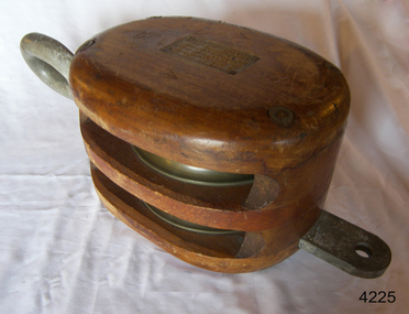
Equipment - Rope Block, After 1950
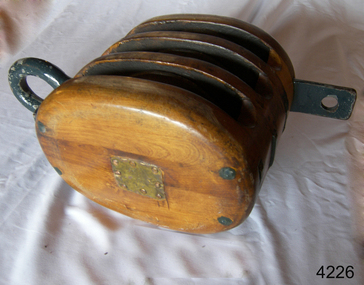
A block and tackle is a simple but highly effective lifting device, thought to have been invented by Archimedes. These systems were used extensively for construction in the ancient world, and continue to be used today for various applications, especially at sea, where non-motorised lifting systems are highly useful. A basic block and tackle includes a single fixed pulley or block, and at least one additional pulley, linked with rope, to form a complete set. Depending on the size of the load being lifted, additional sets may be used to further distribute the weight.A mid-twentieth example of a wooden block that shows advances in the design of the marine block compared to late 19th century blocks, with hook and pin and its compliance plate meeting the marine standards of the time.Two sheave rope block; two metal sheaves in polished wooden block with a metal inner pin with a ring on top and a bucket on the bottom. Rectangle carved into one cheek with inscriptions on the attached compliance plate with inscriptions. Stamped within a lozenge: "2 ↑ CS"flagstaff hill museum, flagstaff hill village, shipwreck coast, flagstaff hill, block & tackle, rope, lifting heavy weights, ship rigging, cargo lifiting, two sheave block, compliance plate, marine technology -
 Flagstaff Hill Maritime Museum and Village
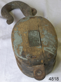
Equipment - Block, After 1950
A block and tackle is a simple but highly effective lifting device, thought to have been invented by Archimedes. These systems were used extensively for construction in the ancient world, and continue to be used today for various applications, especially at sea, where non-motorized lifting systems are highly useful. A basic block and tackle includes a single fixed pulley or block, and at least one additional pulley, linked with rope, to form a complete set. Depending on the size of the load being lifted, additional sets may be used to further distribute the weight.A mid-twentieth example of a wooden block that shows advances in the design of the marine block compared to late 19th century blocks, with hook and pin and its compliance plate meeting the marine standards of the time.Block, three-sheave rope block, wooden with metal sheaves. Metal ring and connecting tab, painted blue-grey. A brass compliance plate is on one cheek. One one side there are eight nails. flagstaff hill museum, flagstaff hill village, shipwreck coast, flagstaff hill, block & tackle, rope, lifting heavy weights, ship rigging, cargo lifiting, marine technology, marine block, three sheave block -
 Flagstaff Hill Maritime Museum and Village
Equipment - Rope Block, Early-to-mid 20th century
A block and tackle is a simple but highly effective lifting device, thought to have been invented by Archimedes. These systems were used extensively for construction in the ancient world, and continue to be used today for a variety of applications, especially at sea, where non-motorized lifting systems are highly useful. A basic block and tackle includes a single fixed pulley or block, and at least one additional pulley, linked with rope, to form a complete set. Depending on the size of the load being lifted, additional sets may be used to further distribute the weight.This wooden two-sheave block is part of a ship's rigging. Its an example of rigging equipment in use from the early-to-mid 20th century and an example of the evolution of rigging equipment since the 17th century.Block; two sheave wooden tackle block with metal rollers and a large metal hook. It has a compliance plate on the side with an inscription. Stamped inside a lozenge; "2 ↑ CS" flagstaff hill museum, flagstaff hill village, shipwreck coast, flagstaff hill, block & tackle, rope, lifting heavy weights, ship rigging, cargo lifiting, rope block, marine technology, ship equipment, rigging, two sheave block -
 Bendigo Historical Society Inc.
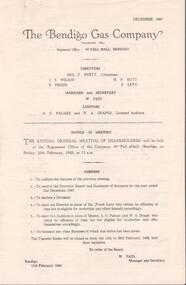
Financial record - Lydia Chancellor collection: Bendigo Gas Company and The Colonial Gas Association Limited
1. The Bendigo Gas Company formed in 1859, established the Bendigo Gas Works and became an incorporated company in 1860. It produced coal gas for the community until it was liquidated and delisted as a company in 1959. 2. The Colonial Gas Association was incorporated in 1888, selling shares for 5pounds and 10 pounds. It was originally formed in London with the aim of raising investment capital for the construction and maintenance of gas works across the cities and towns of Australia and New Zealand. Its original name was the Australasian Gas Association and this changed to the Colonial Gas Association in 1893.The Bendigo Gas Company notice of annual general meeting of shareholders for the years 1947 to 1952. The meeting to be held at the company registered office at 49 Pall Mall, Bendigo. Directors: Rex F. Hyett (Chairman), J.S. Wilson, H.N. Butt, S. Proud, F. Levy. Manager and secretary W. Pain. Also, The Colonial Gas Association Limited notice of annual meeting for the years from 1949 to 1953 to be held at 360 Collins Street, Melbourne. Directors: C.F. Broadhead (Chairman and managing director), James M MacFarlane, Robert Weir, Gerald L. Patterson.bendigo gas comany, the colonial gas association, shareholders -
 Puffing Billy Railway
Floodlight Projector, Tilley Model FL6, circa 1940's
Tilley Floodlight Projector - Model FL6 It stands about a metre high, and when lit, turns out about 5,000 candle power from the parabolic mirror in the back of the lamp. manufactured between the mid 1940's and early '50's It runs on kerosene that is pressurized with the integral pump, to provide a light beam from the parabolic mirror in the back of the lamp of approximately 3,000 candle power which can project over 1/4 of a mile. It features a pressure gauge, armored glass and all steel construction. Historic - Railways - Tilley Floodlight ProjectorTilley Floodlight Projector - Model FL6 made of metal, brass and glass and steelTilley Floodlight Projector - Model FL6puffing billy, tilley floodlight projector -
 Uniting Church Archives - Synod of Victoria
Photograph, undated
The memorial stone of the UMFC in Church St. Richmond was laid in December 1868. The bluestone church, which seated 308 people, was designed by G.R. Cox and built by John Wright. It was opened in May 1869. By 1890 subsidence in the foundations of the building had caused the bluestone façade to bulge dangerously outwards and a new façade of red and white brick was constructed. The memorial stone of the new façade was laid on 7th June 1890. Before construction of the 1868 church, services were held in a weatherboard building which subsequently served as the Sunday School.B & W photograph of the exterior of the Richmond United Free Methodist Church.united free methodist church, church street richmond, bluestone, g.r. cox, john wright. -
 Ballarat Tramway Museum
Photograph - Illustration, "Lydiard and Sturt Streets", c1900
Illustration titled "Lydiard and Sturt Streets" - Centre of Ballarat, showing Post Office. In the bottom left-hand corner is a single-deck horse tram with a Havelock Tobacco advert on the roof. The illustration gives a sweeping wide angle view of the intersection with the Post Office marked with the words "Post Office". There are several horse-drawn vehicles and pedestrians in the view. The image has the initials "HJS" and "PS&Co" on both photos in the bottom corners. On the rear is a photo of the Gong Gong Reservoir with a note about its size and construction - built 1877.Yields information about a single deck horse tram and the intersection of Sturt and Lydiard StreetsIllustration cut from a magazine or publicationballarat, illustrations, sturt st, lydiard st, post office, horse trams, single deck horse tram, gong gong reservoir -
 Ballarat Tramway Museum
Photograph - Geelong No. 5 at the Railway Station, 1915
Photo of Geelong No.5 at the Railway Station, c 1915, Railway station in the background, prior to the extension and the construction of the awning over No. 1 platform area. Has title "Railway Station" along the bottom edge. In the view are signs for Griffiths teas and Bensdorp Cocoa. On the rear "Geelong Historical Post Card Series No. 9 Railway station with No. 5 Tramcar ready to depart for West Geelong 1915" Publisher not known. See also Reg item 4408 for another reproduction of this photograph. Illustration has been cut from a magazine.Yields information about Geelong Railway Station and tram No. 5 in 1915.Sepia-toned print of a postcard and an illustration of the same photograph.trams, tramways, geelong, railway station, tram 5 -
 Queenscliffe Maritime Museum
Functional object - Fishermans Cottage, Built in 1870/1880 for Thomas and Anna Ikin
This low-lying northern-most tip of Queenscliff saw its physical origins in 1863 with allotments let to a burgeoning fishing community previously accommodated on the site of the current railway station and whose construction in 1879 necessitated eviction. Among this community, Chinese fishermen are thought to be of the first international settlers. The success of the fishermen’s settlement was due in part to commercial trading prospects the railway afforded and the size of catch available to those fishing in Bass Strait. Salmon, snapper and particularly barracouta led to the success of the local industry.Original Fishermans Cottage previously located at Swan Bay end of Bridge Street Queenscliff. Timber - Weatherboardfishermen's cottage, fishermen's flat, queenscliff -
 Bendigo Historical Society Inc.
Photograph - Charing Cross and Pall Mall
View of Charing Cross and Pall Mall Bendigo, featuring the Alexandra fountain still under construction. The fountain was jointly funded by the Bendigo Juvenile Industrial Exhibition in 1879, a 500 pound donation by George Lansell and a 700 pound grant from the Sandhurst City Council. The fountain was designed by William Vahland and was opened 5/7/1881. The fountain is 28 feet tall and sits in a 2 feet deep pond that is 50 feet in diameter. It was built with 22 tons of Harcourt granite, cast iron and painted stone.8531 A4 B&W photograph of Charing Cross and Pall Mall, Bendigo, in the late 1800s (prior to automobiles); taken from the City Family Hotel. Photograph shows work underway on the Alexandra Fountain at Charing Cross. Photo shows three trams, pedestrians and some horse drawn vehicles. Pall mall shows Post Office, Shamrock hotel and TAFE towers.charing cross, post office -
 Ballarat Tramway Museum
Functional object - Brass coin holder - 3d and 6d
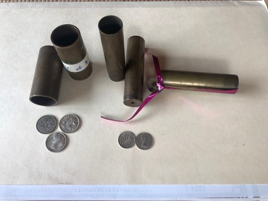
Used by tramway revenue clerks, most likely the MMTB, including the Ballarat Tramway Museum to count coins, as only so many 3d or 6d would fit into each container. Each has a hole in the base to enable it to be checked that it was empty prior to use or after being used. One of the 3d containers have a loose "washer" which shows the nature of the construction. Has been secured with a piece of wrapping tape. One of the 6d tubes has a label advising that it would hold "$30 of $2 coins"Demonstrates the methodologies used to count coins and stack them in a revenue office. Provides a sample of each coin that would have been used. Brass coin holder - for use in counting 3d and 6d coins. Made from brass tube with a brass washer rolled or fixed to one end. In storage bag is are 2 x 3d and a 2 x 6d and 1x5c coins. 5 No. x 6d and 6 No. x 3d holders held in the collection.tramways, tickes, cash, cash handling, depots, coins, revenue clerks -
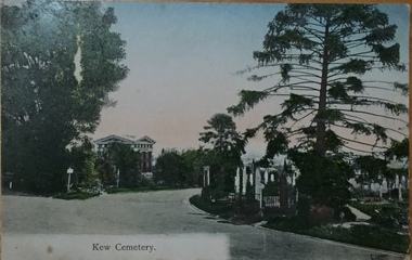 Kew Historical Society Inc
Postcard, Unknown, Kew Cemetery, 1905
This view of the Boroondara General (Kew) Cemetery is dated to 1905 by the inscription and postmark on the reverse. It provides an important visual record of this part of the Cemetery. The postcard can be used to identify the original configuration of the roads and vegetation, some of which was subsequently removed (eg the bunya pine at right). On the Victorian Heritage Database, the construction period given for the Springthorpe Memorial is given as 1897-1907, yet this view of the Memorial in 1905 would suggest that it was virtually completed at an earlier date. (It should be noted that additions such as the wheel of life sculpture were not completed until 1910).This dated photograph is historically important as its inscription confirms it to be one of the earliest postcard representations of the Boroondara General (Kew) Cemetery. It also provides visual evidence of the size and extent of the landscaping by 1905, particularly the layout of the roads (now altered), plantings of the period, and the extent of the land occupied by the Springthorpe Memorial and its gardens, which was subsequently reduced by the trustees of the cemetery in the 1930s. Panoramic view of the entrance driveway in Boroondara General (Kew) Cemetery. At left can be seen the Springthorpe Memorial, and further down on the left the entrance gate, or one of the gates, to the Memorial. Inscribed on reverse: "Miss Brown / Shuan [sic] / Grosvenor Street / M. Brighton. Love from Mother Oct 28th 1905" Postmark: "Melbourne 8 / 2 PM, 28/10/05".springthorpe memorial, boroondara general (kew) cemetery, postcards -- cemeteries -
 Kew Historical Society Inc
Photograph - Yarra in Flood from Willsmere, North Kew, 1923
Flooding of the Yarra Valley, including that section of the Yarra bordering Kew and Kew East in the north and west of the municipality, was a regular occurrence. Extreme flood events of the Yarra River are recorded to have occurred in 1891, 1901, 1916, 1923 and 1934. The Municipality of Kew's response to these floods was to enact planning decisions restricting residential development in flood prone areas following the floods of 1916, 1921 and 1934. While floods continued after the development of the Upper Yarra Reservoir (construction 1948-57), the regularity and extent of these inundations diminished. Original, large sepia photograph showing men, women and children who have gathered on a grassy verge, probably farm land, to look out across the flooded Yarra Valley at Willsmere, North Kew. In the medium distance are three houses that are largely submerged by the flood waters as well as a number of Eucalypts. Judging by the clothes of the spectators, the date might be 1901 or 1916, but probably the latter due to the hats worn by a number of the women. Inscribed reverse: "Gift of Kerrie Woollard (KCC) (P)C.1923yarra river valley, kew east (vic.), floods, willsmere -
 Kew Historical Society Inc
Photograph - Flood at Fairfield Park, 1934
Flooding of the Yarra Valley, including that section of the Yarra bordering Kew and Kew East in the north and west of the municipality, was a regular occurrence. Extreme flood events of the Yarra River are recorded to have occurred in 1891, 1901, 1916, 1923 and 1934. The Municipality of Kew's response to these floods was to enact planning decisions restricting residential development in flood prone areas following the floods of 1916, 1921 and 1934. While floods continued after the development of the Upper Yarra Reservoir (construction 1948-57), the regularity and extent of these inundations diminished.Black and white print positive. Yarra River at Fairfield in 1934. Major flood resulting in submerged buildings in middle ground and onlookers on far bankReverse: "Flood of Yarra at Fairfield Park 1934"fairfield park, yarra valley, river yarra, floods -- 1934 -
 Kew Historical Society Inc
Photograph - Yarra in Flood, 1934
Flooding of the Yarra Valley, including that section of the Yarra bordering Kew and Kew East in the north and west of the municipality, was a regular occurrence. Extreme flood events of the Yarra River are recorded to have occurred in 1891, 1901, 1916, 1923 and 1934. The Municipality of Kew's response to these floods was to enact planning decisions restricting residential development in flood prone areas following the floods of 1916, 1921 and 1934. While floods continued after the development of the Upper Yarra Reservoir (construction 1948-57), the regularity and extent of these inundations diminished.Black and white print positive. 1934 floods of the Yarra Valley. Location Fairfield looking towards wooded hillside. Houses floating in river.Reverse: "From Fairfield Park (11936?) back towards hill (Wurundjeri Spur?)"floods -- 1934, yarra valley, yarra river, fairfield park -
 Kew Historical Society Inc
Photograph - River Yarra in Flood from Kilby Road
Flooding of the Yarra Valley, including that section of the Yarra bordering Kew and Kew East in the north and west of the municipality, was a regular occurrence. Extreme flood events of the Yarra River are recorded to have occurred in 1891, 1901, 1916, 1923 and 1934. The Municipality of Kew's response to these floods was to enact planning decisions restricting residential development in flood prone areas following the floods of 1916, 1921 and 1934. While floods continued after the development of the Upper Yarra Reservoir (construction 1948-57), the regularity and extent of these inundations diminished.Print copy of an original photo of the River Yarra in Flood, taken from Kilby Road.VIEW ACROSS YARRA IN FLOOD / FROM KILBY RD KEWkilby road, floods -- kew (vic.), kilby farm -
Kew Historical Society Inc
Collection, Floods in North Kew (Series), 1929–1934
Flooding of the Yarra Valley, including that section of the Yarra bordering Kew and Kew East in the north and west of the municipality, was a regular occurrence. Extreme flood events of the Yarra River are recorded to have occurred in 1891, 1901, 1916, 1923 and 1934. The Municipality of Kew's response to these floods was to enact planning decisions restricting residential development in flood prone areas following the floods of 1916, 1921 and 1934. While floods continued after the development of the Upper Yarra Reservoir (construction 1948-57), the regularity and extent of these inundations diminished. Natural disasters had an impact on the development and settlement of Melbourne and its suburbs. Flooding in the Melbourne region was a regular event in the nineteenth and for most of the twentieth centuries. Changes in the impact of natural disasters could occur due to a number of factors. This collection of small snapshots, mostly taken from Kellett Grove in North Kew, provide provenanced evidence of flooding in the area before the development of the unnatural flood barrier that is the Eastern Freeway.Collection of 16 monochrome photographs, annotated on verso by different hands, of the flooding of the River Yarra in North Kew in the third and fourth decades of the twentieth century [1920s & 1930s]. Individual photos include the dates of different floods. Many of the photos were taken from the rear of 8 Kellett Grove; a house still extant in 2023yarra river -- north kew, floods -- yarra valley, floods -- north kew, floods -- 1929, floods -- 1934, natural disasters -- kew -
 Kew Historical Society Inc
Photograph - Removal of the horse tram line in Riversdale Road, Hawthorn, E.J. Dower, c.1916
One of a series of photographs, taken by Edgar James Dower in the second decade of the twentieth century. Born and raised in Olinda, his family later moved to Surrey Hills. He worked as an adult as a clerk in the city office of the Metropolitan Gas Company, and in his role as a 'collector', he was able to photograph scenes including the construction of tramlines and associated buildings in Kew, Hawthorn, Camberwell and Surrey Hills. Later he established a real estate agency with his brother - the E.J. Dower Real Estate Agency, Dandenong Office.The image is an historically significant record of the development of transport infrastructure which was used to connect Victorians in the first two decades of the twentieth century. This development resulted from increases in population and the consequent extension of Melbourne's suburbs. The photographs, both individually and collectively, richly detail the labour of workers and the tools and machinery used to create and extend Melbourne's tram network in the years preceding and during World War 1.Digital copy of an original mounted photograph of the removal of the horse tram tracks in Riversdale Road, Hawthorn, in preparation for laying the new electric tramline.Annotated verso: "Pulling up Hawthorn horse tram line in Riversdale Road, which ran from Hawthorn Bridge to Auburn Road"theme --- travelling by tram, theme -- connecting victorians by transport and communications, trams -- boroondara (vic.), horse tram -- hawthorn (vic.), riversdale road -
 Kew Historical Society Inc
Photograph - Construction of the electric tram line in Riversdale Road, Camberwell, E.J. Dower, 1916
One of a series of photographs, taken by Edgar James Dower in the second decade of the twentieth century. Born and raised in Olinda, his family later moved to Surrey Hills. He worked as an adult as a clerk in the city office of the Metropolitan Gas Company, and in his role as a 'collector', he was able to photograph scenes including the construction of tramlines and associated buildings in Kew, Hawthorn, Camberwell and Surrey Hills. Later he established a real estate agency with his brother - the E.J. Dower Real Estate Agency, Dandenong Office.The image is an historically significant record of the development of transport infrastructure which was used to connect Victorians in the first two decades of the twentieth century. This development resulted from increases in population and the consequent extension of Melbourne's suburbs. The photographs, both individually and collectively, richly detail the labour of workers and the tools and machinery used to create and extend Melbourne's tram network in the years preceding and during World War 1.Digital copy of an original oval mounted photograph depicting preparation for laying the tracks for the new electric tramline in Riversdale Road, Camberwell. Annotated verso: "Riversdale Road / Preparing for electric tram line / Taken from near corner of Coolangatta Road"theme --- travelling by tram, theme -- connecting victorians by transport and communications, riversdale road -- camberwell, trams -- camberwell -
 Kew Historical Society Inc
Photograph - Entrance to the Boroondara General (Kew) Cemetery, E.J. Dower, 1913
One of a series of photographs, taken by Edgar James Dower in the second decade of the twentieth century. Born and raised in Olinda, his family later moved to Surrey Hills. He worked as an adult as a clerk in the city office of the Metropolitan Gas Company, and in his role as a 'collector', he was able to photograph scenes including the construction of tramlines and associated buildings in Kew, Hawthorn, Camberwell and Surrey Hills. Later he established a real estate agency with his brother - the E.J. Dower Real Estate Agency, Dandenong Office.The image is an historically significant record of the development of transport infrastructure which was used to connect Victorians in the first two decades of the twentieth century. This development resulted from increases in population and the consequent extension of Melbourne's suburbs. The photographs, both individually and collectively, richly detail the labour of workers and the tools and machinery used to create and extend Melbourne's tram network in the years preceding and during World War 1.Digital copy of an original mounted photograph showing the entrance to the Boroondara General (Kew) Cemetery in 1913. The entrance was/is on the corner of High Street and Parkhill Road. The horse drawn tram from Victoria Street Bridge to the Cemetery can be seen to the left of the photo in High Street. Note also the extensive bluestone gutters in Parkhill Road.Annotated verso: "Entrance to Kew Cemetery? / 1913"theme --- travelling by tram, theme -- connecting victorians by transport and communications, trams -- kew (vic.), high street. -- kew (vic.), parkhill road -- kew (vic.) -
 Kew Historical Society Inc
Photograph - Railway level crossing in Glenferrie Road, Glenferrie, E.J. Dower, 1912-13
One of a series of photographs, taken by Edgar James Dower in the second decade of the twentieth century. Born and raised in Olinda, his family later moved to Surrey Hills. He worked as an adult as a clerk in the city office of the Metropolitan Gas Company, and in his role as a 'collector', he was able to photograph scenes including the construction of tramlines and associated buildings in Kew, Hawthorn, Camberwell and Surrey Hills. Later he established a real estate agency with his brother - the E.J. Dower Real Estate Agency, Dandenong Office.The image is an historically significant record of the development of transport infrastructure which was used to connect Victorians in the first two decades of the twentieth century. This development resulted from increases in population and the consequent extension of Melbourne's suburbs. The photographs, both individually and collectively, richly detail the labour of workers and the tools and machinery used to create and extend Melbourne's public transport network in the years preceding and during World War 1.Digital copy of an original mounted photograph showing the old railway crossing in Glenferrie Road, Hawthorn. The removal of the train level crossing and the elevation of the rail line above the road was designed to enable the laying of tram tracks along Glenferrie Road. The buildings to the right of the photo were being demolished to allow for this. "The Don Store" is immediately behind the crossing.Annotated verso: "1912 / Demolishing shops near Glenferrie Railway Station, just prior to the regrading of line to camberwell / Taken by E.J. Dower 1912"theme --- travelling by tram, theme -- connecting victorians by transport and communications, glenferrie railway station, glenferrie road -- hawthorn (vic.), railways -- hawthorn -
 Kew Historical Society Inc
Photograph - Construction of the electric tram line in Glenferrie Road, Glenferrie, E.J. Dower, 1914
One of a series of photographs, taken by Edgar James Dower in the second decade of the twentieth century. Born and raised in Olinda, his family later moved to Surrey Hills. He worked as an adult as a clerk in the city office of the Metropolitan Gas Company, and in his role as a 'collector', he was able to photograph scenes including the construction of tramlines and associated buildings in Kew, Hawthorn, Camberwell and Surrey Hills. Later he established a real estate agency with his brother - the E.J. Dower Real Estate Agency, Dandenong Office.The image is an historically significant record of the development of transport infrastructure which was used to connect Victorians in the first two decades of the twentieth century. This development resulted from increases in population and the consequent extension of Melbourne's suburbs. The photographs, both individually and collectively, richly detail the labour of workers and the tools and machinery used to create and extend Melbourne's public transport network in the years preceding and during World War 1.Digital copy of an original mounted photograph showing a worker standing on a ladder in Glenferrie Road, Hawthorn, working on the overhead electric cables that would be used to power trams on the New Kew tramline.Other railway workers are working on platforms or viewing the man on the ladder. The ladder appears to be only supported by one other worker. "The Don Store" at left is immediately behind the old railway level crossing which can be seen in the distance to the south.Annotated verso: "Preparing for electric trams in Glenferrie Road, near Glenferrie Station, showing railway gates / Taken by E.J. Dower 1914"theme --- travelling by tram, theme -- connecting victorians by transport and communications, glenferrie road -- hawthorn (vic.), railways -- hawthorn