Showing 6392 items matching " red white "
-
 City of Kingston
Photograph - Black and white, c. 1970
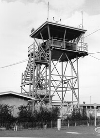
Moorabbin Airport was acquired in 1946 by a group of aviators and the Civil Aviation Department, Moorabbin Airport opened as a fully-functioning aerodrome in December 1949, chosen for its ideal location in the Market Gardens for an aviation base to be situated southeast of Melbourne. Black and white photograph of the control tower at Moorabbin Airport. At the base of the tower is a single storey brick building with a wire fence at the running across the front.Handwritten in black ink on reverse: 701 Handwritten in red ink on reverse: 100%moorabbin, airport, aviation -
 City of Kingston
Photograph - Black and white, c. 1963
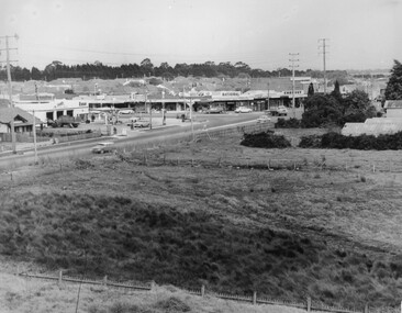
This image depicts the intersection of increasing urbanisation and the rural landscape that once made up the area now known as City of Kingston.Black and white photograph of the intersection of Warrigal Road and Centre Road, South Oakleigh, viewed from the reservoir. In the foreground are paddocks and in the background is a shopping strip, including a petrol station.Handwritten in blue ink on reverse: 2196 Handwritten in red ink on reverse: 100%oakleigh, roads, shopping strip, paddocks -
 City of Kingston
Photograph - Black and white, c. 1957
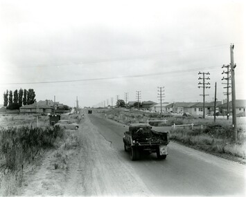
This image shows the urbanisation of a formerly rural area of Moorabbin.Black and white photograph looking west along South Road. There is a truck in the foreground, travelling along the sealed South Road. A car is waiting to exit from Rowan Road. People are walking along the left hand side of the road, and a young person a bike is riding along the right side. They are all going in the same direction as the traffic. The left hand side of the image shows paddocks in the foreground, which houses further back. The right hand side of the image shows suburban houses with electricity poles running the length of the road. Handwritten in blue ink on reverse: 57-523A Handwritten in red ink on reverse: 85% Handwritten in black ink or grey lead: Ch. 6moorabbin, cars, roads, housing -
 City of Kingston
Photograph - Black and white, 1957
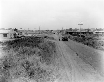
This image shows the increasing urbanisation of the formerly rural area of Moorabbin.Black and white photograph of the intersection of South Road and Chesterville Road, Moorabbin. A service station is visible on the left hand side, a truck is travelling along the road and shops are under construction on the right hand side.Handwritten in blue ink on reverse: 57-523B Handwritten in red ink on reverse: 100%moorabbin, shopping strip, paddocks, roads, cars -
 City of Kingston
Photograph - Black and white, c. 1957
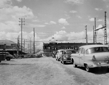
This image depicts the increasing urbanisation of Moorabbin. While there are several cars in line waiting for the train to go through the crossing and the gates to open, in the distance there is a lot of activity on the road, with many cars.Black and white photograph depicting the railway crossing at South Road, Moorabbin. There is a 'Red Rattler' passenger train going through the level crossing travelling towards the city.Handwritten in blue ink on reverse: 57-4078 Handwritten in red ink on reverse: 82% Handwritten in black ink on reverse: Ch. 6moorabbin, trains, cars, urbanisation, suburbs -
 City of Kingston
Photograph - Black and white, c. 1950
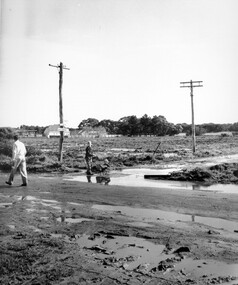
Black and white photograph depicting the intersection of Balcombe Road and Haywood Street in Beaumaris. The road is unsealed and recent rain has left it boggy and slushy. A man in very light coloured clothes is walking along the road with a newspaper in his left hand. A young boy is pushing a trolley of some kind with two wheels in which another younger child is sitting.Handwritten in red ink on reverse: 92% Handwritten in blue ink on reverse: 2196beaumaris, roads, infrastructure, puddles, children -
 City of Kingston
Photograph - Black and white, c. 1958
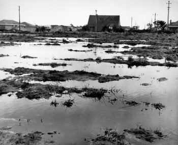
Unsealed roads and drainage problems created difficulties for those living in Beaumaris during the 1950sBlack and white image depicting the Balcombe Road and Haywood Street, Beaumaris. Unsealed roads and drainage problems have created boggy slushy land. There are houses in the background, indicating people live in the area.Handwritten in red ink on reverse: 90% Handwritten in blue ink on reverse: 2193beaumaris, roads, drainage, water logged, housing -
 City of Kingston
Photograph - Black and white, Percy Fairlam, c. 1910
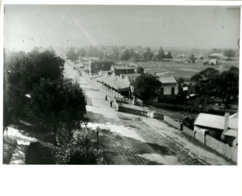
Black and white image of Cheltenham in the early 20th Century depicts an almost idyllic life. This photo was taken by Percy Fairlam, who climbed a tall pine tree to achieve the aerial view. The tree was a well recognised feature of the Cheltenham skyline but was cut down some time before World War II.Cheltenham was established as a rural market gardening community. The development of the railway was crucial to the ongoing development of the area. Community life sprung up around the railway line which is evident in the proximity of shopping and leisure.Black and white image depicting aerial view down Charman Road, Cheltenham, including the unsealed road, level crossing and shopping centre. What appears to be a cricket pitch is located behind the shops.Handwritten in black ink on a red round sticker adhered to the reverse, and then crossed out: X14 Handwritten in blue ink on reverse: A8 Handwritten in red ink on reverse: 85%cheltenham, railway crossing, roads, housing, shopping strip -
 City of Kingston
Photograph - Black and white, Public Transport Corporation, c. 1960
This image is part of a larger collection of images from the Public Transport Corporation displaying train stations and streetscapes in what is now the City of Kingston.The development of the railway was crucial to the ongoing development of the area. Community life sprung up around the railway line which is evident in the proximity of shopping and leisure.Black and white photograph of railway gates at Centre Road, Bentleigh.Black printed text on a small, round, white sticker on reverse: 227 Handwritten in red ink on reverse: 50% Black typed text on a strip of white paper stuck on reverse: Gates Centre Road Bentleigh / mid 1960 / $50 reproduction fee applies Blue ink stamped on reverse: COPYRIGHT / Public Transport Corporation / For re-ordering photographs / Please quote negative No H 3407 / Enquiries C/- PTC Photographic Unit / Telephone switchboard 619 1111bentleigh, railway crossing, trains, suburbs, shopping strip -
 City of Kingston
Photograph - Black and white, c. 1950
This image shows a sealed road running along South Road, although with a wide gravel shoulder. The railway crossing gates were hand operated. This image is one of many in the collections that focuses on the railway. The development of the railway was crucial to the ongoing development of the area. Community life often sprang up along and beside the railway.Black and white photograph of the railway crossing at South Road, Moorabbin, viewed from Nepean Highway. Handwritten in blue ink on reverse: 217 Handwritten in red ink on reverse: 80%moorabbin, railway, railway crossing -
 City of Kingston
Photograph - Black and white, c. 1950
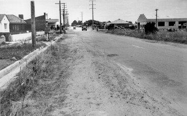
While the road is sealed, there is evidence of potholes that have been filled, and the wide, gravel shoulder has long grass running into the gutter of the nature strip. On the other side of the road, extremely long grass can be seen growing on the side of the road. There is a truck visible on the road, which indicates the rural nature of the Cheltenham community in the 1950s.This image is one of many in the collections that focuses on the railway or roads. The development of roads and the railway was crucial to the ongoing development of the area. Black and white photograph of the intersection of Warrigal and Centre Dandenong roads, Cheltenham. On the left hand side is a small sign warning of a cross roads intersection. Housing and shops line the road.Handwritten in blue ink on reverse: 219 Handwritten in red ink on reverse: 80%cheltenham, roads, suburbs -
 City of Kingston
Photograph - Black and white, 1950
This photograph depicts the increasing urbanisation of a once rural area at Moorabbin.This image is one of many in the collections that focuses on either roads or the railway. The development of roads and the railway was crucial to the ongoing development of the area. Black and white photograph of South Road, Moorabbin, with Station Street to the right and Jasper Road further down to the left. Along both sides of the road are retail spaces which become homes on the left hand side, after Jasper Road.Handwritten in red ink on reverse: 80% Handwritten in blue ink on reverse: 216moorabbin, roads, cars, shopping strip, housing -
 City of Kingston
Photograph - Black and white, c. 1950
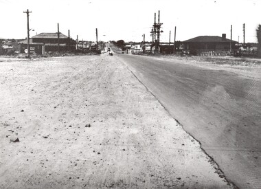
The intersection of Warrigal Road and Nepean Highway is now a major intersection, serviced by traffic lights. In the 1950s it was a joining of two sealed roads, although covered in gravel, and with wide gravel shoulders. There are no traffic signs and the few houses visible are not set very far back from the road. This image is one of many in the collections that focuses on either roads or the railway. The development of roads and the railway was crucial to the ongoing development of the area.Black and white photograph of the intersection of Warrigal Road and Nepean Highway, Mentone. Handwritten in blue ink on reverse: 218 Handwritten in red ink on reverse: 75%mentone, roads, suburbs -
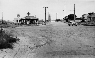
 City of Kingston
Photograph - Black and white, c. 1950
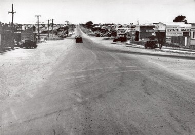
This image highlights the rural nature of the area during the 1950s where areas that are now major highways and intersections appear like country roads.Black and white photograph of the intersection of Warrigal Road and Centre Road in Oakleigh. There is a truck travelling south toward the camera along Warrigal Road which is a sealed road. On the right hand side is a Caltex petrol station with a street sign for Centre Road.Handwritten in blue ink on reverse: 2191 Handwritten in red ink on reverse: 72%oakleigh, cars, roads, suburbs -
 City of Kingston
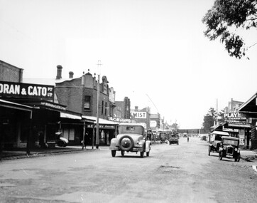
Photograph - Black and white, c. 1925
This image explores the relationship between the train lines and community development. Cheltenham's retail centre is connected to the train station.Black and white image of Charman Road, Cheltenham, depicting a car and truck travelling toward the level crossing near the train station. There is another car already waiting at the crossing gates. Cars are parked on either side of the road along a shopping strip.Black printed text on a white round sticker adhered to the reverse: 141 Handwritten in red ink on reverse: 50% Black typed text on a white strip of paper adhered to reverse: Charman Road, Cheltenham / circa late 1920's/early 1930's / $50 reproduction fee applies Blue ink stamped on reverse: COPYRIGHT / Public Transport Corporation / For re-ordering photographs / Please quote negative ADV 485 / Enquiries C/- PTC Photographic Unit / Telephone switchboard 619 1111cheltenham, trains, railway, railway crossing, shopping strip, cars -
 City of Kingston
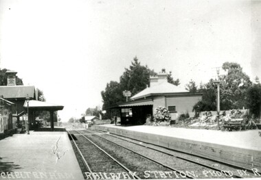
Photograph - Black and white, Percy Fairlam, c. 1920
Cheltenham station was built in 1898 and serviced a primarily rural, market gardening community.The late 1870s saw the beginning of a massive program to construct railway lines throughout Victoria. One of these lines was from Caulfield to Frankston. A survey undertaken by J P Madden, an engineer employed by the railways, established the route, although this was later modified. At the time of the official opening of the line to Mordialloc no station buildings had been constructed despite the fact that tenders had been called in the Government Gazette of 26 May 1881 and subsequently in the Argus newspaper on 30 August 1881 for what became stations at Glenhuntly, Ormond, Bentleigh, Moorabbin, Highett, Cheltenham, Mentone and Mordialloc. However platforms and sidings were completed, ready to receive passengers. Cheltenham station opened in 1898.Black and white photograph of Cheltenham Railway Station with the two platforms separated by two sets of tracks. Each platform has a station house on it, and the one on the right hand side also has a garden and park bench.Handwritten in red ink on reverse: A7 / 75%cheltenham, trains, railway, railway station, railway crossing, suburbs -
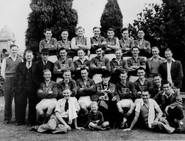 City of Kingston
Photograph - Black and white, c. 1940
Members of the Bentleigh football team after presumably winning a premiership as the man seated in the front is holding a cup.Black and white photograph with four rows of men, and one child, grouped together in a traditional sporting photo. Most men are wearing the Bentleigh Football Club uniform but on either side of the third row there are men in street clothes, as are the two men sitting at the front.Black printed text on white round sticker adhered to reverse: 210 Handwritten in red ink on reverse: 72%bentleigh, football, team, sport -
 City of Kingston
Photograph - Black and white, c. 1948
Located in the southern Melbourne suburb of Bentleigh, on the corner of Centre Road and Nicholson Street. The Bentleigh Theatre was opened in 1924. By 1946 it was operated by Hoyts Theatres and was modernised in 1948. It was closed in 1984 and has since been demolished.Black and white photograph of the entrance foyer of the Hoyt's theatre in Bentleigh. On the right hand side is a poster for the movie 'Mother Wore Tights' starring Bette Grable. To the left is the start of a staircase which presumably turns to the left taking movie-goers upstairs.Black printed text on white round sticker adhered to the reverse: 188 Handwritten in red ink on reverse: 80%theatre, movies, entertainment -
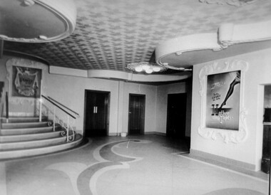
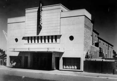 City of Kingston
Photograph - Black and white, c. 1948
Located in the southeast Melbourne district of Ormond. The Ormond Theatre was opened in the late-1920’s with 720 seats in stalls and circle. There was no ceiling in the auditorium, which allowed for the steel roof trusses to be seen. In 1930 a Western Electric(WE) sound system was installed. In 1940 it was remodelled in a simple Art Deco style to the plans of architectural firm Marsh & Michaelson. It re-opened in 1941 with 995 seats. By 1946 it was operated by Albert Park Cinemas Property Ltd. The Plaza Theatre was closed on 30th November 1958. It was converted into a carpet showroom which was still operating in late-1984. The building has since been demolished.Black and white photograph depicting the art deco facade of the newly refurbished Plaza Theatre, Ormond. There are no buildings either side of the theatre which highlights its large size.Black printed text on white round sticker adhered to reverse: 187 Handwritten in red ink on reverse: 72%theatre, movies, entertainment, plaza, suburbs -
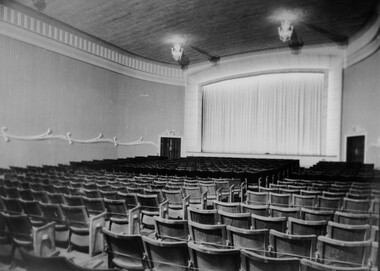
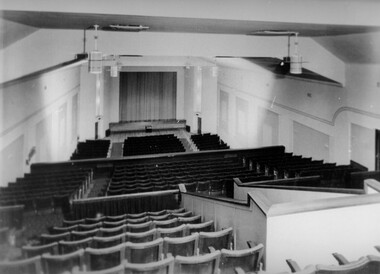 City of Kingston
Photograph - Black and white, c. 1948
Located in the southeast Melbourne district of Ormond. The Ormond Theatre was opened in the late-1920’s with 720 seats in stalls and circle. There was no ceiling in the auditorium, which allowed for the steel roof trusses to be seen. In 1930 a Western Electric(WE) sound system was installed. In 1940 it was remodelled in a simple Art Deco style to the plans of architectural firm Marsh & Michaelson. It re-opened in 1941 with 995 seats. By 1946 it was operated by Albert Park Cinemas Property Ltd. The Plaza Theatre was closed on 30th November 1958. It was converted into a carpet showroom which was still operating in late-1984. The building has since been demolished.Black and white photograph of the theatre inside the Plaza Theatre. The photograph has been taken at the rear of the theatre and looks down over the three tiers of seating toward the screen.Black printed text on white round sticker adhered to reverse: 186 Handwritten in red ink on reverse: 77%theatre, movies, entertainment, suburbs -
 City of Kingston
Photograph - Black and white, c. 1948
Located in the southeast Melbourne suburb of Bentleigh, on the corner of Centre Road and Nicholson Street. The Bentleigh Theatre was opened in 1924. By 1946 it was operated by Hoyts Theatres and was modernised in 1948. It was closed in 1984 and has since been demolished.Black and white photograph taken from the ground level inside the theatre, with a view of the screen.Black printed text on white round sticker adhered to reverse: 189 Handwritten in red ink on reverse: 72%theat, movies, entertainment -
 City of Kingston
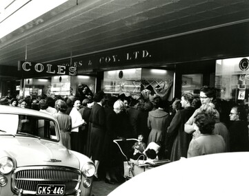
Photograph - Black and white, 13 September 1956
The newly opened Coles store in Bentleigh attracted a huge crowd of women on opening day.Black and white photograph depicting a crowd of women, some with prams and children, at the entrance to the newly opened Coles store in Bentleigh.Handwritten in blue ink on a white sticker adhered to the reverse: COLES BENTLEIGH / OPENING DAY 13/9/1956 Handwritten in red ink on reverse: 165% Printed black text on a white round sticker adhered to the reverse: 200suburbs, domesticity, shopping, consumerism -
 City of Kingston
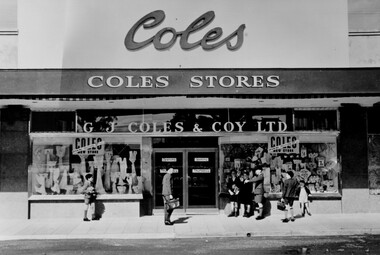
Photograph - Black and white, 1949
The Coles store in Moorabbin opened in 1949.Black and white photograph depicting the as yet unopened Coles store in Moorabbin with a group of boys standing around the front. The boys don't appear to be taking any particular interest in the store but the photograph provides an excellent view of the facade of the store.Handwritten in blue ink on white sticker on reverse: COLES MOORABBIN / 1949 Printed black text on white sticker on reverse: 203 Handrwitten in red ink on reverse: 70%shopping, consumerism, suburbs -
 City of Kingston
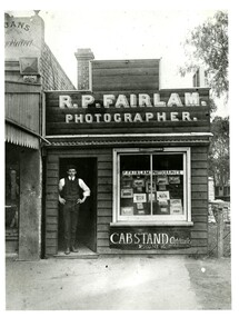
Photograph - Black and white, c. 1910
Percy Fairlam was an early 20th Century photographer living and working in Cheltenham. Fairlam captured important social and landscape scenes in and around the Cheltenham area including cliff faces, sea baths, and rock pools. With the outbreak of World War I (WWI), Fairlam began training in Seymour and documented preparations for war, comradeship and the voyage to France and war. Shrapnel to the shoulder, on 4 January 1917, saw Fairlam evacuated to England and resulted in him being separated from his personal possessions. As such, all these images have been lost. After the war, Fairlam moved into the family business and no longer pursued professional photography. However, he continued to take an interest in the art form capturing intimate family moments as well as continuing to capture social and landscape scenes.Black and white photograph of a Richard William Percy Fairlam (Percy Fairlam) standing in the doorway of a small wooden building. Above the doorway is a painted sign advertising it as the photography business of R.P. Fairlam. In the large window at the front of the shop a number of photographs can be seen.Handwritten in red ink on reverse: 115% Black printed text on a white round sticker on reverse: 71 -
 City of Kingston
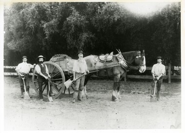
Photograph - Black and white, c 1900
Black and white photograph of workers with a horse and card preparing the Sandringham Oval, possibly for football. Person 2 and 3 (from L to R) identified as William John Selby and [no first name] McInerneyHandwritten in red ink on reverse: 55% Black printed text on white round sticker adhered to reverse: 48sport, horse, manual labour -
 City of Kingston
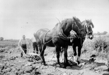
Photograph - Black and white, c. 1920
Horses were frequently used to assist in the manual labour of farming right up to the mid twentieth century. This image was taken while ploughing market garden fields in Moorabbin.Black and white image of two Clydesdale horses attached to harness and pulling a plough. Two men are behind the horses, one is holding the handles of the plough and the other is standing next to him with his hands on his hips.Handwritten in red ink on reverse: 70% Printed in black text on white round sticker adhered to reverse: 41horses, manual labour, farming, moorabbin -
 City of Kingston
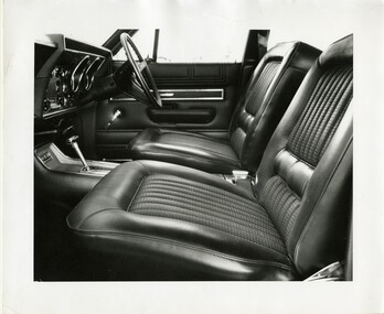
Photograph - Black and white, 1970
This photograph displays the car seat and trims of a Ford Motor vehicle, which were manufactured by Nylex Plastics in Mentone.Nylex Plastics was considered to be the largest manufacturing company in Australia and in the top 25 largest companies in the country and has its origins with the Australian Moulding Corporation founded by John Derham in Mentone in 1927Black and white photograph of a car interior, showing the two front seats, gearstick, steering wheel and dashboard. Stamped in red and green ink: NYLEX PHOTOGRAPHY FILE / DIVISION Fabrics [Handwritten in black ink] / CODE No 208B [Handwritten in black ink] / DATE 29/12/70 / DESCRIPTION Ford [Handwritten in black ink]cars, ford, nylex, nylex plastics, car interior -
 City of Kingston
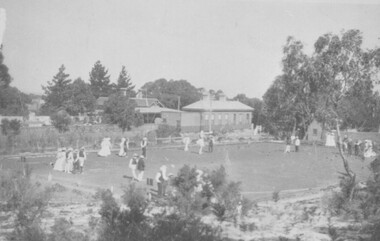
Photograph - Black and white, Percy Fairlam, c.1910
Cheltenham Bowls Club, which was located to the rear of Cheltenham Railway station. This photograph was taken by Percy Fairlam, who opened a photographers shop in Charman Road. Percy took many of the best known photographs of Cheltenham at the turn of the century.This photograph was taken by Percy Fairlam, who opened a photographers shop in Charman Road. Percy took many of the best known photographs of Cheltenham at the turn of the century.Black and white photograph of people bowling at the Cheltenham Bowling Club, depicting a large area of lawn surrounded by trees and bushes, with buildings in the background. There are several groups of men and women standing on the lawn in front of a series of small balls.Printed in black ink on a round white sticker: 111 Handwritten in red ink: 90%. Handwritten in red ink: K000603leisure, bowls, games -
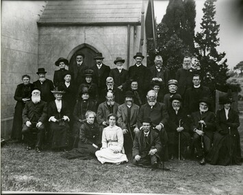 City of Kingston
Photograph - Black and white, c.1913
Members of Cheltenham Presbyterian Church at a Jubilee Celebration. Included in the photograph are Reverend Malcolm McQueen, Reverend Finlay McQueen, Selena McQueen (nee Bruton), Reverend Malcolm McQueen, Teena McQueen, Mary Read, Tom Keiller, John Morey.The Pioneers Presbyterian Church Cheltenham was founded in 1858. In July 2023 BayChurch Presbyterian was formed from the union of St Andrew’s Presbyterian Church Mordialloc (commenced 1885) and Pioneers Memorial Presbyterian Church Cheltenham.A black and white photograph of a large group of men and women all looking at the camera, in front of a building. Handwritten in red ink: Rev Finlay McQueen / Selena (nee Bruton) McQueen / Rev Malcolm McQueen / Teena McQueen / Mary Read / Tom Keiller / John Moreyreligion, church, presbyterian, jubilee, church elders -
 City of Kingston
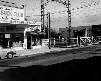
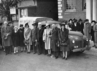
Photograph - Black and white, c.1943
This photograph shows members of the community outside the Moorabbin Council Offices, handing over a brand-new utility truck for use by the Australian Comforts Fund, in support of the war effort. It was purchased with funds raised by contestants in Moorabbin's 'Popular Girl Quest'. Contestants received a vote for each penny they collected. The winner was Gladys Mariott, pictured centre wearing a sash, who raised £528 10s, earning her 126,800 votes. In total, the contestants raised more than a thousand pounds, which enabled the purchasing of the new utility truck.Members of the Moorabbin community were keen to play their part in supporting the war effort. A black and white photograph of a group of men and women standing in front of and behind a utility vehicle with the license plate FA 341. There are two buildings in the background, one of which has a sign out the front that reads "Moorabbin Free Library & Mechanics Institute". The photograph was taken outside Moorabbin Council offices to illustrate the handing over of utility truck for use by Australian Comforts Fund. Money for the truck was raised by the 'Popular Girl Quest' won by Gladys Marriott (centre wearing sash)Handwritten in red ink: A 600 / 72% Handwritten in black ink: CHAP 6. / WITH SUB-STORY / Spy base -- / OR general pix / in Chap 6 / referring to warworld war ii, australian comforts fund, popular girl quest, fundraising, war efforts, vehicles