Showing 3757 items
matching 1978
-
 Ringwood and District Historical Society
Photograph, The Telecom gang laying pipes in Kubis Drive, North Ringwood, near Jenkins Close, on 10th June 1978
E550 N5 Part of a 51-photo record of the development of the "Kubis" Estate, Ringwood North, including road works to Debbie Place, Kubis Drive, Werac Drive, Manuelo Drive, Iluka Place and Glenvale Road. From the Jack Lundy Clarke collection. -
 Ringwood and District Historical Society
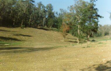
Photograph, Kubis Estate, North Ringwood in April 1978. View of the lake site looking east. The wall was where the track bends. The rope tree was on the hillside beyond the track bend
E548 N35 This photo was taken from almost the same spot as the 1976 one. Part of a 51-photo record of the development of the "Kubis" Estate, Ringwood North, including road works to Debbie Place, Kubis Drive, Werac Drive, Manuelo Drive, Iluka Place and Glenvale Road. From the Jack Lundy Clarke collection. -
 Ringwood and District Historical Society
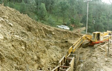
Photograph, Kubis Estate, North Ringwood in April 1978. Looking upstream from below the retaining wall of Loughnan's Lake that was where the truck tracks disappear. The wall was extended to the left across what was then a small gorge
E548 N19 Part of a 51-photo record of the development of the "Kubis" Estate, Ringwood North, including road works to Debbie Place, Kubis Drive, Werac Drive, Manuelo Drive, Iluka Place and Glenvale Road. From the Jack Lundy Clarke collection. -
 Ringwood and District Historical Society
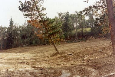
Photograph, Kubis Estate, North Ringwood in April 1978. Looking west across Kubis and Werac Drives over the full length of Loughnan's Lake site. Main pool was behind the lone pine
E548 N29 Part of a 51-photo record of the development of the "Kubis" Estate, Ringwood North, including road works to Debbie Place, Kubis Drive, Werac Drive, Manuelo Drive, Iluka Place and Glenvale Road. From the Jack Lundy Clarke collection. -
 Ringwood and District Historical Society
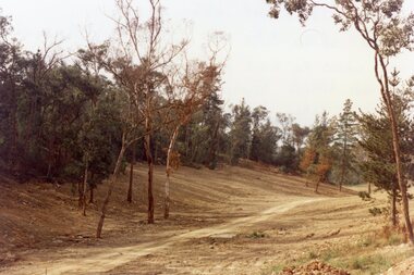
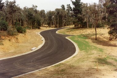
Photograph, Kubis Estate, North Ringwood in April 1978. Looking up the hill in Kubis Drive from the site of headwaters of Loughnan's Lake. Jenkins Close takes off to the right from centre
E548 N31 Part of a 51-photo record of the development of the "Kubis" Estate, Ringwood North, including road works to Debbie Place, Kubis Drive, Werac Drive, Manuelo Drive, Iluka Place and Glenvale Road. From the Jack Lundy Clarke collection. -
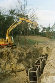
 Ringwood and District Historical Society
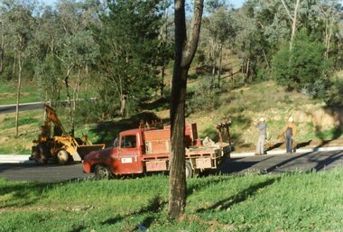
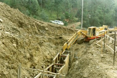
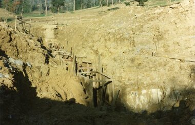
Photograph, Kubis Estate, North Ringwood on 16 June 1978. Kato working on final trench. The hole for the 27 feet deep well is seen beyond the trench
E550 N10 Part of a 51-photo record of the development of the "Kubis" Estate, Ringwood North, including road works to Debbie Place, Kubis Drive, Werac Drive, Manuelo Drive, Iluka Place and Glenvale Road. From the Jack Lundy Clarke collection. -
 Ringwood and District Historical Society
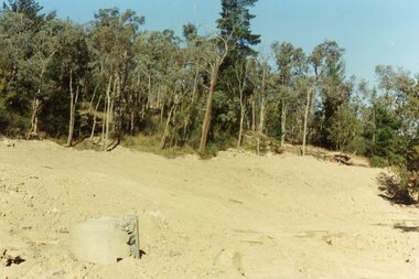
Photograph, Kubis Estate, North Ringwood in February 1978. The site of Loughnan's Lake seen from the north end of the wall. The rope tree was on the hillside on the left
E546 N2 Part of a 51-photo record of the development of the "Kubis" Estate, Ringwood North, including road works to Debbie Place, Kubis Drive, Werac Drive, Manuelo Drive, Iluka Place and Glenvale Road. From the Jack Lundy Clarke collection. -
 Ringwood and District Historical Society
Photograph, Kubis Estate, North Ringwood on 10 June 1978. Temporary end of Kubis Drive at junction with Debbie Place. The car stands at junction with Pamela Place
E550 N8 Part of a 51-photo record of the development of the "Kubis" Estate, Ringwood North, including road works to Debbie Place, Kubis Drive, Werac Drive, Manuelo Drive, Iluka Place and Glenvale Road. From the Jack Lundy Clarke collection. -
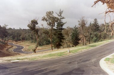
 Ringwood and District Historical Society
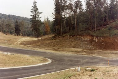
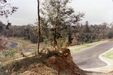
Photograph, Kubis Estate, North Ringwood in April 1978. View east up Kubis Drive over Jenkin Close and intersection with Werac Drive
E549 N18 Part of a 51-photo record of the development of the "Kubis" Estate, Ringwood North, including road works to Debbie Place, Kubis Drive, Werac Drive, Manuelo Drive, Iluka Place and Glenvale Road. From the Jack Lundy Clarke collection. -
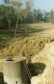 Ringwood and District Historical Society
Photograph, Kubis Estate, North Ringwood on 16 June 1978. The concrete wall 27 feet deep at the pumping station in Glenvale Road
E550 N12 Part of a 51-photo record of the development of the "Kubis" Estate, Ringwood North, including road works to Debbie Place, Kubis Drive, Werac Drive, Manuelo Drive, Iluka Place and Glenvale Road. From the Jack Lundy Clarke collection. -
 Ringwood and District Historical Society
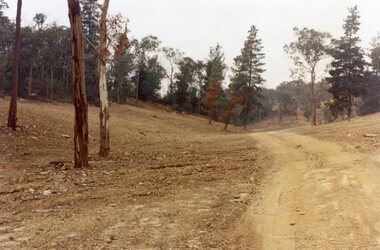
Photograph, Kubis Estate, North Ringwood in April 1978. View east up Kubis Drive from Jenkin Close past the foot of Werac Drive
E549 N16 Part of a 51-photo record of the development of the "Kubis" Estate, Ringwood North, including road works to Debbie Place, Kubis Drive, Werac Drive, Manuelo Drive, Iluka Place and Glenvale Road. From the Jack Lundy Clarke collection. -
 Ringwood and District Historical Society
Photograph, Kubis Estate, North Ringwood on 16 June 1978. The Kato lifts a bucket out of the trench
E550 N11 Part of a 51-photo record of the development of the "Kubis" Estate, Ringwood North, including road works to Debbie Place, Kubis Drive, Werac Drive, Manuelo Drive, Iluka Place and Glenvale Road. From the Jack Lundy Clarke collection. -
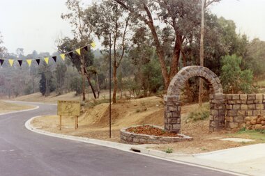 Ringwood and District Historical Society
Photograph, Werac Drive, North Ringwood, entrance to Bel-Air Country Club in April 1978
E548 N11 Part of a 51-photo record of the development of the "Kubis" Estate, Ringwood North, including road works to Debbie Place, Kubis Drive, Werac Drive, Manuelo Drive, Iluka Place and Glenvale Road. From the Jack Lundy Clarke collection. -
 Ringwood and District Historical Society
Photograph, Kubis Estate, North Ringwood on 10 June 1978. Trench for sewer below the manhole
E550 N7 The hole for the 27 feet deep well shows as a white patch, lower right. Part of a 51-photo record of the development of the "Kubis" Estate, Ringwood North, including road works to Debbie Place, Kubis Drive, Werac Drive, Manuelo Drive, Iluka Place and Glenvale Road. From the Jack Lundy Clarke collection. -
 Ringwood and District Historical Society
Photograph, Site of the main body of Loughnan's Lake, North Ringwood on 10 June 1978. the rope tree was on the slope, far left
E550 N6 Part of a 51-photo record of the development of the "Kubis" Estate, Ringwood North, including road works to Debbie Place, Kubis Drive, Werac Drive, Manuelo Drive, Iluka Place and Glenvale Road. From the Jack Lundy Clarke collection. -
 Ringwood and District Historical Society
Photograph, Kubis Estate, North Ringwood on 16 June 1978, using the Kato as a crne to de-water final trench
E550 N9 Part of a 51-photo record of the development of the "Kubis" Estate, Ringwood North, including road works to Debbie Place, Kubis Drive, Werac Drive, Manuelo Drive, Iluka Place and Glenvale Road. From the Jack Lundy Clarke collection. -
 Ringwood and District Historical Society
Photograph, Site of Loughnan's Lake, North Ringwood in April 1978
E548 N33 The leaning pine tree grew on the lake shore after 1950. It also was used as a rope tree by the children. Part of a 51-photo record of the development of the "Kubis" Estate, Ringwood North, including road works to Debbie Place, Kubis Drive, Werac Drive, Iluka Place and Glenvale Road. From the Jack Lundy Clarke collection. -
 Moorabbin Air Museum
Magazine (Item) - Ansett "Outlook" Staff Magazines 1970s<>1980s & Boeing "Airliner" 1978
-
 Ringwood and District Historical Society
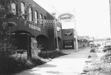
Photograph, Maroondah Highway West, Ringwood- 1978. 15 mile peg at Guest's Furniture Store
Black and white photographPhotograph shows Guest's Furniture Forum store, and also the original 15 mile cement marker. -
 Wodonga & District Historical Society Inc
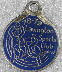
Badge - Lavington Sports Club Membership 1978 - 1979
The Lavington Sports Ground, former home of the Lavington Sports Club, is now owned and operated by Albury City Council. Over 50 years ago, a group of Lavington locals dreamed of building a new sportsground to encourage more people to play sport, particularly juniors. The original oval opened in 1973. The Sports Ground was developed solely by the Lavington Sports Club, formed by 30 football and cricket players and supporters in 1964. Football and cricket clubs had existed in Lavington since before 1914. In 1964, the football and cricket clubs merged to become the Lavington Sports Club. The new club and facilities were established on land initially leased from the Divine Sword Missionaries on their former seminary and turkey farm. The club expanded its facilities and representative sports throughout the next 20 years, including hosting international events. However the Club's debt worsened and In 2001 the entire Lavington Sports Club operation went into liquidation. It was taken over by Penrith Panthers through the Panthers Entertainment Group. In July 2009 the Albury City Council purchased the Sports Ground and has further redeveloped the ground and its facilities.This badge is representative of the role played by sporting organisations in the local communityA circular blue and silver enamelled badge issued for membership of the Lavington Sports Club.On front of Badge "78 -79/Lavington/Sports/Club/Limited" On reverse "MEMBER/NOT TRANSFERABLE/6114/PERFECTION BADGES/SYDNEY/770775"lavington sports club, recreational facilities albury, sport and recreation -
 Wodonga & District Historical Society Inc
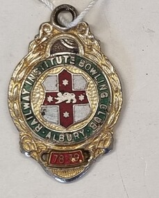
Badge - Railway Institute Bowling Club Albury 1978 - 79
The New South Wales Railway Institute affectionately known as “the Institute”, was initially established to provide a higher standard of educational learning for NSW railway employees. As well as employment related training, the Institute was tasked with stimulating growth and intellectual development of employees in the arts, social, leisure, and physical recreations. The NSW Railway Institute was formally opened on the 14th of March 1891 and at the time was the only institution of its kind in the Commonwealth. The Albury branch of the Railways Institute was formed on March 1, 1921. This included the building of a Railway Institute building as part of the Railway precinct in 1921. On Tuesday 7 October 1952, the Daily Advertiser, Wagga reported that a move had started at Albury for the establishment of a third bowling club. The new club formed would be the Railway Institute Bowling Club and the suggested site was on Albury City Council land at the corner of Young and Smollett streets. The Albury Railway Institute opened its bowling greens in February 1956. It later became known as Windsor Park Bowling Club. In 2003, the Bowling Club was liquidated and was amalgamated with the Albury Soldiers Sailors & Airmen’s Club. After changes to their operating model, the club building was demolished in 2013. This badge is representative of the role played by the NSW Railway Institute for its members and its involvement in the broader community.Member's badge for the Railway Institute Bowling Club Albury. A small metal badge with enamel finish depicting the logo of the club in green, red, gold and white.Around the central logo "RAILWAY INSTITUTE BOWLING CLUB ALBURY/ 78-79"railway institute, bowling clubs, social activities albury -
Lakes Entrance Regional Historical Society (operating as Lakes Entrance History Centre & Museum)
Book, Land Conservation Council Victoria, The Gippsland Lakes Land Use Strategy Plan 1978, 1985
A review of public land use in the East Gippsland area, including natural resources, flora and fauna, recreation. Contains photographs, maps statistics.conservation, aboriginals, primary industry -
 Kew Historical Society Inc
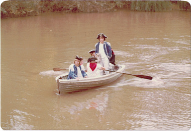
Photograph - Historic re-enactment during the Festival of Kew, 1978
At the 1978 Festival of Kew, a number of organisations, including the City of Kew, the Kew Historical Society, Trinity Boys Grammar School and local Girl Guides participated in a re-enactment of the expedition of the party of Charles Grimes in surveying the Yarra River as far as Kew in February 1803. The location for the event was Yarra Bend Park near the Studley Park Boat House. The event was organised by the Kew Historical Society. The re-enactment was captured by a number of amateur photographers as well as by a photographer from the local Progress Press.Local communities select events to commemorate according to their shared history and values. Commemorations of colonial exploration were popular with local historical groups such as the Kew Historical Society in the twentieth century. In re-enacting events such as the Grimes survey of the Yarra, students from a local school were encouraged to take on specific roles, including play-acting individuals involved in the survey party as well as members of the local Wurundjeri People. The photographs, taken by amateur and professional photographers, represent a period in time when the dominant values were those shared by the descendants of European settlers in Victoria. Original colour photographic positive of Cr Allan Hutchinson reciting the program of events at the Charles Grimes re-enactmentAnnotated on reverse: "CR HUTCHINSON READING PROGRAM / 1978 FESTIVAL"kew historical society, trinity grammar school, kew girl guides, city of kew, yarra river, charles grimes, collins expedition, wurundjeri people, yarra bend park, colonial surveys, historic re-enactments, festival of kew, kew festival -
 Whitehorse Historical Society Inc.
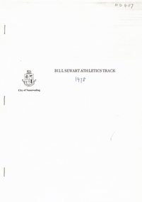
Document, Bill Sewart Athletic Track, 1978
Submission to City of Nunawading to construct an all-weather 400 metre athletics track.Submission to City of Nunawading to construct an all-weather 400 metre athletics track for the use of residents in the Nunawading district including supportive submissions from various bodies within the community, dated 1978.Submission to City of Nunawading to construct an all-weather 400 metre athletics track. sportsgrounds, city of nunawading, nunawading combined athletics committee, east burwood reserve, bill sewart athletic track, ralphsmith, john -
Whitehorse Historical Society Inc.
Article, Livingstone School Has Schedule, 21/10/1976 12:00:00 AM
Plans for the new Primary SchoolPlans for the new Primary School in Livingstone Road, Vermont South, due to open in 1978, on display.Plans for the new Primary Schoolprimary schools, walton, trevor, vermont south primary school -
 Bendigo Military Museum
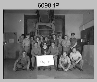
photograph - Camera Section, Lithographic Squadron at the Army Survey Regiment, Bendigo, 1976, 1978 and 1979
This is a set of three photograph of Camera Section, Lithographic Squadron, one of the Army Survey Regiment’s four squadrons, at Fortuna, Bendigo in 1976, 1978 and 1979. The main tasks undertaken by Camera Section’s technicians were photographic enlargements, reductions and duplication of map reproduction material, and processing of aerial photography. Photo .2P was taken with Camera Section in front of the Klimsch Commodore camera on the 5th of October 1978, before its decommissioning. It was replaced with a new Klimsch model with computerised control, improved speed and consistent controlled output.This is a set of three photograph of Camera Section, Lithographic Squadron, Army Survey Regiment at Fortuna, Bendigo, c1970s. The black and white photographs wererprinted on photographic paper and are part of the Army Survey Regiment’s Collection. The photographs were scanned at 300 dpi. .1) - Photo, black & white, 1976, Back Row L to R: unidentified, Garry Hudson, unidentified, Greg Kidman, Bob Chamberlain, Mick ‘Buddha’ Ellis, Zoe (Lisiewich) Ames, Bill Jones, Trevor Osborne, Dave Miles, Chris Osborne. Front Row L to R: Frank Lenane, Gavin Neilson, Joanne Green, Warren ‘Waldo’ Shirley, Peter Coombes, John Nicholls. .2) - Photo, black & white, 5th Oct 1978, Back Row L to R: CPL Bob Chamberlain, Greg Kidman, SSGT George Graham, Chris Osborne, John Nicholls, Frank Lenane, Terry Edwards, Bill Jones, Gary Kenny, Peter Imeson. Front Row L to R: CPL Warren ‘Waldo’ Shirley, Mick ‘Buddha’ Ellis, CPL Garran Hill. .3) - Photo, black & white, 1979, Back Row L to R: WO2 George Graham, CAPT Stan Vote, Peter Imeson, Gary Tremain, Penny Knott, Zoe (Lisiewich) Ames, Di Chalmers, Rob Bogumill, Bill Jones, Rhys De Laine, Brian Fauth, John McCracken. Front Row L to R: SGT Ralph Chant, SGT Garran Hill, CPL Gavin Neilson, Frank Lenane, Paul Baker, SSGT Trevor Osborne.No personnel are identified. Each photo is annotated on the front. .1P annotated ‘1976’ .2P annotated ‘CAMERA SECT 5 Oct 1978 The Last of the old Klimsch’ .3P annotated ‘Camera ‘79’royal australian survey corps, rasvy, army survey regiment, army svy regt, fortuna, asr, litho -
 Wangaratta Urban Fire Brigade
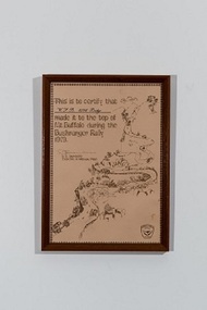
frame picture
Certificate that the Wang urban fire brigade 'dodge' made it to the top of Mt Buffalo in 1978simple brown frame with a certificate This is to certify that the 'W. F. B 1938 Dodge' made it to the top of Mt Buffalo during the Bushranger rally 1979. signed by D.S Saunders Director of National Parks (top right quarter) (illustration of winding road over the other 3/4) 1978, dodge -
Glen Eira City Council History and Heritage Collection
Document (Item) - Newspaper (digital), Caulfield Contact, 1978
The Caulfield Contact was the official newspaper of the City of Caulfield from 1976-1994. The City of Caulfield was the Municipal Council for an area of the South Eastern suburbs of Melbourne, including Brighton East, Carnegie, Caulfield, Elsternwick, Gardenvale, Glen Huntly, McKinnon, Murrumbeena, Ormond and St Kilda East. Following Amalgamation of City of Caulfield and parts of the City of Moorabbin in 1994, the Caulfield Contact was followed by the Glen Eira News. Contains References to the following Freedom of Entry to 3rd ordinance of the RAAOC, visit by Sir Zelman Cowen, Return to Rosstown, A 'spacy new home' (nursery at Caulfield Park), Profile on Gus Theobold, Meals on Wheels Aviary completed Caulfield Park. Profile resident Gus Theobold. Cr Irene Capek win Herald Australia Day essay prize. Caulfields Meals on Wheels set Victorian record. Historical feature Return to Rosstown. New ambulance station Glenhuntly and Clarinda roads opens. Volume 4 Number 5 Date 03 August 1978 Features Where and How to Vote in council election. Cr Irene Capek retires from council. Profiles election candidates. Image: Image Cr Irene Capek. Images of election candidates. Volume 5 Number 1 Date 14 September 1978 Freedom of Entry to 3rd ordinance of the RAAOC, visit by Sir Zelman Cowen, Subjects from Carol: GG Sir Zelman Cowen and Lady Cowen offical visit. Off street carpark project underway Pyne St and Hawthorn Rd. City Manager Graeme Caldwell submits plans for Townhall renovations. Action plan for development of Elsternwich Shopping precint to be developed. Freedom of Entry ceremony. Profile Rosemary Keppel. Booran Motors Glenhuntly donate dual control Holden Gemini to Caulfield Tech school pre-driver education program. council election results. Comments from elected Crs Jack Campell, Bob Baxter, Dorothy Ford, Brian Rudzki. Promotion of Caulfield Institute of Technology and TAFE. Image: Image Sir Zelman Cowen, Lady Cowen. Images Freedom of Entry ceremony and citizens attending. Image Rosemary Keppel. Cartoon pre-driver education program. Image Mayor Cr Geoff Patience in robes. Volume 5 Number 2 Date 26 October 1978 Rate rise 5.73% announced. Readership of Caulfield Contact surveyed. Caulfield ranger Reg Dixon and members of works dept rescue duck family from drain and reinstate them to Caulfield Racecourse dam. Profile resident and teacher Claire Manning. Image: Image of Reg Dixon and the rescued ducks. Image Claire Manning and students at Waverley Private school. city of caulfield, caulfield, glen eira, city of glen eira, caulfield contact, freedom of entry to 3rd ordinance of the raaoc, visit by sir zelman cowen, return to rosstown, a 'spacy new home' (nursery at caulfield park), profile on gus theobold, meals on wheels -
 Kew Historical Society Inc
Photograph - Historic re-enactment during the Festival of Kew, 1978
At the 1978 Festival of Kew, a number of organisations, including the City of Kew, the Kew Historical Society, Trinity Boys Grammar School and local Girl Guides participated in a re-enactment of the expedition of the party of Charles Grimes in surveying the Yarra River as far as Kew in February 1803. The location for the event was Yarra Bend Park near the Studley Park Boat House. The event was organised by the Kew Historical Society. The re-enactment was captured by a number of amateur photographers as well as by a photographer from the local Progress Press.Local communities select events to commemorate according to their shared history and values. Commemorations of colonial exploration were popular with local historical groups such as the Kew Historical Society in the twentieth century. In re-enacting events such as the Grimes survey of the Yarra, students from a local school were encouraged to take on specific roles, including play-acting individuals involved in the survey party as well as members of the local Wurundjeri People. The photographs, taken by amateur and professional photographers, represent a period in time when the dominant values were those shared by the descendants of European settlers in Victoria. Original colour photographic positive showing six boys from Trinity Grammar School in a boat on the Yarra at Studley Park in a re-enactment of the survey party of Charles Grimes of February 1803.Annotated on reverse: "TRINITY BOYS AS GRIMES PARTY ON YARRA / 1978 FESTIVAL"kew historical society, trinity grammar school, kew girl guides, city of kew, yarra river, charles grimes, collins expedition, wurundjeri people, yarra bend park, colonial surveys, historic re-enactments, festival of kew, kew festival -
Glenelg Shire Council Cultural Collection
Document - Commemorative Menu from the Mac's Hotel Portland, 1978
Commemorative menu from Mac's Hotel 8/11/1978 Commemorating 100 years since Captain Fawthrop's death