Showing 1582 items
matching clarke
-
 Bendigo Historical Society Inc.
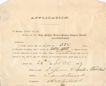
Document - COHN BROTHERS COLLECTION: APPLICATION FORM FOR SHARES
Application form dated 24th Oct 1887 directed to Messrs Clarke and Co, Brokers for 'Cohns Brothers Victoria Brewery Company Limited' request from William Charles Vahland that 500 shares in Cohns be allocated to him. Signed by Vahland.bendigo, industry, cohn bros brewery -
 Bendigo Historical Society Inc.
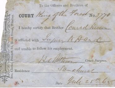
Document - ANCIENT ORDER OF FORESTERS NO. 3770 COLLECTION: CORRESPONDENCE
Printed Doctor's Certificate To Court King of the Forest No. 3770, dated July 25th 65. Conrad Heisen was unable to follow his employment. Signed by H. L. Atkinson. Printed by Bro. Clarke, Printer, 84, Moor Street, Fitzroy.societies, aof, correspondence, ancient order of foresters no. 3770 collection - correspondence, court king of the forest, conrad heisen, h l atkinson, bro clarke -
 Bendigo Historical Society Inc.
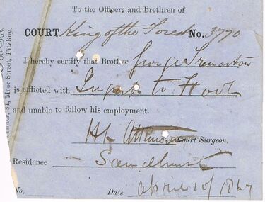
Document - ANCIENT ORDER OF FORESTERS NO 3770 COLLECTION: DOCTOR'S CERTIFICATE
Blue Doctor's Certificate dated April 10 1867 certifying that ? ?renaston of Sandhurst was unable to follow his usual employment. Signed by H. L. Atkinson, Court Surgeon. Printed by Bro. Clarke, Printer, 84, Moor Street, Fitzroysocieties, aof, correspondence, ancient order of foresters no 3770 collection - doctor's certificate, court king of the forest, ? ?renaston, h l atkinson, bro clarke -
 Bendigo Historical Society Inc.
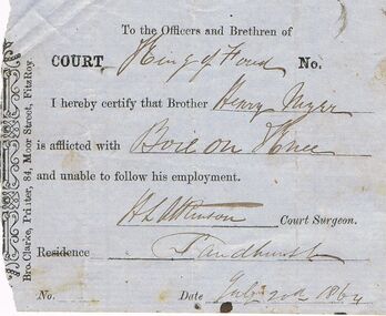
Document - ANCIENT ORDER OF FORESTERS NO 3770 COLLECTION: DOCTOR'S CERTIFICATE
Blue Doctor's Certificate dated July 20th 1864 certifying that Henry ? Of Sandhurst was unable to follow his usual employment. Signed by H. L. Atkinson, Court Surgeon. Printed by Bro. Clarke, Printer, 84, Moor Street, Fitzroy.societies, aof, correspondence, ancient order of foresters no 3770 collection - doctor's certificate, court king of the forest, henry ?, h l atkinson, bro clarke -
 Mt Dandenong & District Historical Society Inc.
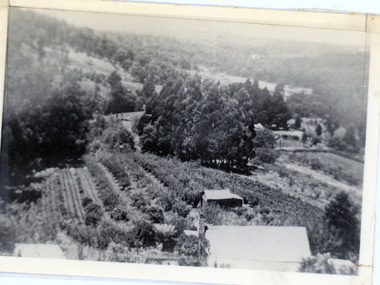
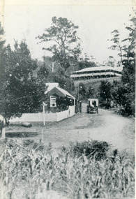
Photograph, 1913 View Over Logan's House in Village Settlement, 1913
Photograph taken in 1913 from Barbers Road showing the view down the valley. Roof in foreground is house on Bob Logan's Lot 28 in the Village Settlement. This photograph has a detailed inscription on the back handwritten by John Lundy-Clarke in 1974.1913 view over Logan’s house on Village Settlement Lot 28 taken from Barber’s Road. This is the house that the runaway log leaped over in 1930 to land far down the orchard row beyond the house. “Shiloah” is centre partly behind the clump of trees and the paddocks of Child and Richardsons pioneer selections are in the background. Link Road is centre right.logan, bob logan, robert logan, barbers road, shiloah, child, richardson, link road -
 Bendigo Historical Society Inc.
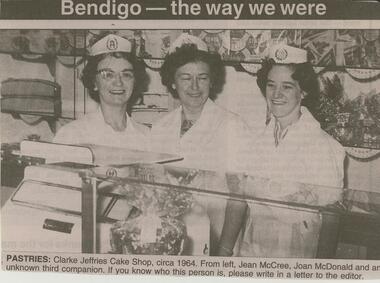
Newspaper - JENNY FOLEY COLLECTION: PASTRIES
BHS CollectionBendigo Advertiser ''The way we were'' from Monday, December 15, 2003. Pastries: Clarke Jeffries Cake Shop, circa 1964. From left, Jean McCrae, Joan Mc Donald and an unknown third companion. The clip is in a folder.newspaper, bendigo advertiser, the way we were -
 Bendigo Military Museum
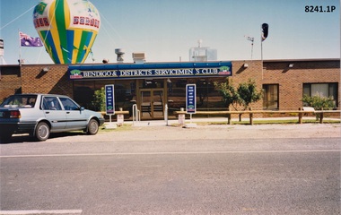
Photograph - SERVICEMAN'S CLUB, C.1994
These two images are most likely at the opening of the Bendigo District Servicemen’s Club after the renovations finished early in 1994. On the left is Bill Clarke, next to him is Max O’Haloran. William (Bill) Clarke was President of the Servicemen’s Club from 1992 - 96. Max O’Haloran was President of the Club 1991 - 2, he was also President of the Bendigo RSL on two occasions. Refer Cat No's 8073P, 8171 & 8230.2.1) Photograph colour showing the front of the Bendigo District Servicemen’s Club, a ballon is showing overhead. .2) photograph colour showing an advertisement for some of the Clubs attractions. .3) & .4) photographs colour shows the same two men from different angles in front of the Servicemen’s Club.brsl, smirsl, bdsc -
 Bendigo Military Museum
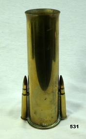
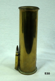
Memorabilia - TRENCH ART, BRASS VASE, Post 1941 -42
Item belonged to Arthur C Clarke VX79039 2nd AIF. Refer 532 for main details. Item 530 goes with this to make a pair. Vase , brass, made from a 2 pounder shell. The top is flared out. On each side is attached 2 x .303 cartridges at base.2 PR No 21, 518 MF , WC 1942↑ CF No 12 TPG 5/41, 59 ME 11/41arms - ammunition, metalcraft, brassware, ornaments - metals/vases, trench art -
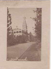 Sunbury Family History and Heritage Society Inc.
Photograph
Rupertswood Mansion was the Sunbury residence of the Clarke family from 1874 until 1922 when H.V.McKay of Sunshine Harvester fame bought it from Hon. W.L. Russell Clarke in 1922. After the death of H.V.McKay in 1926, it was purchased by W. Naughton who then sold the mansion and 700 acres of land to the Salesian Fathers, who are the present owners. It is now the site of Salesian College, a Catholic co-educational college fore secondary students.Rupertswood Mansion has had close social, spiritual and educational links with Sunbury's development since 1874.A small sepia photograph with a cream frame of a driveway leading to a large mansion. 'RUPERTSWOOD' written in the LH corner of the photograph.rupertswood mansion, clarke, w.j.t., mckay, h.v., salesian college -
 Melbourne Tram Museum
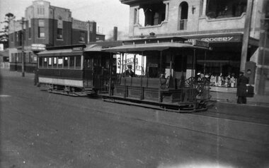
Negative - Cable car 593 at Collingwood terminus, Wal Larsen, c1939
Photograph of a cable car set , trailer No. 593 at the Collingwood terminus in Johnston Street at Clarke Street. The grip man is sitting on his seat while the Conductor is attending to the Bundy (Cincinnati type) clock by the Grocery Shop. In the background is the Study Park Hotel at the corner of Clarke Street. An advertisement for Swallows Ice Cream appears on the Grocery Shop. Photo Wal Larsen. Print undated, probably at the time of the closure of the Collingwood line in 1939.Yields information about the Collingwood cable tram terminus.Negative and black and white print with notes on the rear.On rear in ink "593 outside Collingwood depot, Johnston St, Collingwood, photo Wal Larsen" and number "168" in top right hand corner.trams, tramways, cable trams, collingwood, johnston st, tram 593, clarke st, abbotsford, studley park hotel -
 Bendigo Historical Society Inc.
Document - ANCIENT ORDER OF FORESTERS NO. 3770 COLLECTION: CORRESPONDENCE
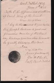
Letter To the C.R. Officers and Brethren of Court King of the Forest written on cream paper and dated June 5 1872. Letter is a reference for Bro Joseph Andrews. Letter is stamped with a black powder.Signed by Geo H. Clarke Sec. Court Talbot 3879societies, aof, correspondence, ancient order of foresters no. 3770 collection - correspondence, court talbot, court king of the forest, joseph andrews, geo h clarke -
 Bendigo Historical Society Inc.
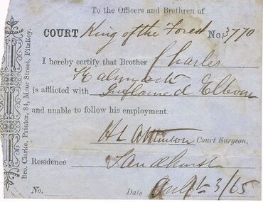
Document - ANCIENT ORDER OF FORESTERS NO 3770 COLLECTION: DOCTOR'S CERTIFICATE
Blue Doctor's Certificate dated July? 3 1865 certifying that Charles Kalynack of Sandhurst was unable to follow his usual employment. Signed by H. L. Atkinson, Court Surgeon. Printed by Bro. Clarke, Printer, 84, Moor Street, Fitzroy.societies, aof, correspondence, ancient order of foresters no 3770 collection - doctor's certificate, court king of the forest, charles kalynack, h l atkinson, bro clarke -
 Bendigo Historical Society Inc.
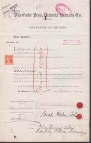
Document - COHN BROTHERS COLLECTION: TRANSFER OF SHARES CERTIFICATE 1895
Cohn Brothers Victoria Brewery 200 shares of Alfred Nicholson transferred to Sarah Helen Cohn dated 24th Oct 1895. One penny duty stamp. Oval Red Clarke & Company 309 Collins St Melbourne hand stamped.bendigo, industry, cohn bros brewery, alfred nicholson. sarah helen cohn -
 Mt Dandenong & District Historical Society Inc.
Photograph, Erith Lane
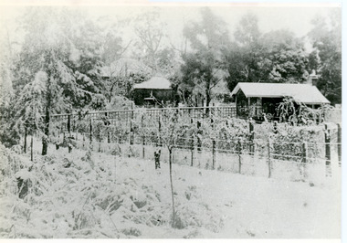
Erith Lane would have been named after Eliza Erith, the wife of Thomas Hand of Mountain Grange. The house made of slabs and bark pictured (centre) is where the family lived before Mountain Grange was built. Mabel Hand, Thomas and Eliza's youngest daughter stated that she was born in the bark hut in 1881 and they moved into the new home the same year. Cherry Farm, the roof visible behind the centre building, was the home of William Hand, son of Thomas and Eliza. He lived here with hs wife, Harriet Toghill, before moving to live at Mountain Grange after 1905.Black and white photograph showing a scene under heavy snow. Two cottages and a rooftop visible. Snow laden vines forming the front fence. Taller trees visible in the background. Reverse of photograph has handwritten description by John Lundy-Clarke.Erith Lane under snow. House in passion fruit Ivory’s holiday home 1921. Building in centre was Hand’s 28’ by 22’ house of slabs and bark. The first house on top of the whole Dandenong Range built 1871. Large roof behind it was “Cherry Farm”.eliza erith, eliza hand, mabel hand, thomas hand, william hand, erith lane, kalorama, snow, mountain grange, cherry farm, harriet toghill -
 Mt Dandenong & District Historical Society Inc.
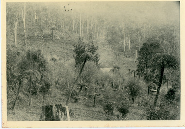
Photograph, Home of George Dodd at Olinda 1895, 1895
1895 picture of the home of George Dodd built c1880. Shows the Selector's Road made in the 1880s from Pig Lane in The Basin to the road in front of the Mt dandenong Hotel.The descriptive text on the reverse of this photograph was hand written by John Lundy-Clarke.1895 picture of the home of George Dodd built about 1880 showing the road the selectors made in the 1880s from Pig Lane to the main road in front of the present Mt Dandenong Hotel near the present end of the Basin-Olinda Road. It was never gazetted as a road as the Bruces objected to it and landslides in 1891 closed it temporarily and later landslides closed it permanently.george dodd, dodd, mt dandenong hotel, selector's road, road, pig lane -
 Mt Dandenong & District Historical Society Inc.
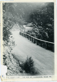
Photograph, The New Mt Dandenong Road, Vic
Copy of Rose Series postcard #385 showing the new Mt Dandenong Tourist Road with wooden railing fence on low side of road. Surface not yet made. This photograph has a detailed inscription on the back handwritten by John Lundy-Clarke in 1974.View downhill from the Windy Bend showing the site of the 1972 landslide. In this picture the road is running along the top edge of the wall 900’ thick of Kalorama Docite that plunges thousands of feet deep down into the earth below the Ranges and extends to Fern Tree Gully. It was once a horizontal terrace nearly ten miles square and tipped over to the left when the mountain subsided into its volcanic cauldron.mt dandenong road, rose series, windy bend, landslide -
 Mt Dandenong & District Historical Society Inc.
Photograph, The Gap at Kalorama 1913, 1913
1913 scene looking up to Mountjoy Guest House at the Kalorama Gap (FiveWays). Post Office and tea rooms with white picket fence. Jeeves Coach on the road. This photograph has a detailed inscription on the back handwritten by John Lundy-Clarke in 1974. The Gap Kalorama 1913. ‘Mountjoy’ guest house. Mount Dandenong North Post Office. Jeeves coach.fiveways, mountjoy, post office, mt dandenong north, the gap, jeeves, coach -
 Eltham District Historical Society Inc
Photograph, Eltham District Historical Society, 2018 Community Group of the Year, 2018 Nillumbik Australia Day Awards, Eltham Community and Reception Centre, Main Road, Eltham, 26 January 2018
Members of the Eltham District Historical Society celebrate being awarded the Nillumbik 2018 Community Group of the Year award with Mayor Cr. Peter Clarke.Born Digital2018 community group of the year, ceremonies, cr. grant brooker, eltham community and reception centre, eltham district historical society, mayor cr. peter clarke, nillumbik shire council -
 Greensborough Historical Society
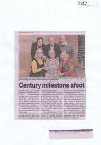
Newspaper clipping, Century milestone afoot, 24/06/2015
Mavis Clarke celebrated her 100th birthday with her family in June 2015. She recalls riding her horse to school in Lower Plenty.News clipping, black text, colour image.mavis clarke, lower plenty -
 Stawell Historical Society Inc
Photograph, Stawell Grammar School 1908
Donor Marion is Great Great niece of Angus Henry Clarke Shire Engineer of Stawell. His son Ronald possibly a student of the Grammar School.Two Black and white photographs of Stawell Grammar School 1902/3 & 1908Roseleigh House March 25th 1908. 1902/1903 on back of photo with child in garden 1908 on back of both photographs roseleigh, education -
 Bendigo Military Museum
Memorabilia - TRENCH ART, BRASS VASE, Post 1941
Item belonged to Arthur C Clarke VX79039 2nd AIF. Refer 532 for main details. Item 531 goes with is one to make a pair.Case , brass, made from a 2 pounder shell , top is flared out. On one side at base is attached a .303 cartridge. One .303 cartridge is missing on opposite side.2 Pr No 2 237 MF , HX 1941 C IL↑ No 12 1 PG 5/41, 6 ME7/41arms - ammunition, ornaments -metal, vases, metalcraft, brassware, trench art -
 Mission to Seafarers Victoria
Photograph, Mr and Mrs Gurney Goldsmith, Resting, Easter Monday, Heatherbrae, 12 April 1909
Alfred Edward Clarke was a member of the Stock Exchange. He married a niece of Reverend Kerr Johnston, Margaret Helen Gowan (daughter of John Denovan Gowan, himself brother of Eliza Denovan Gowan) in 1886. His first wife, Caroline Long, died in 1884. One of his daughter, Linda Clarke (later married to John William Begg) was secretary of the Malvern branch of the Ladies' harbour Lights Guild. Article in the Standard (Port Melbourne, Vic. : 1884 - 1914), Saturday 17 April 1909, page 3 "SAILORS ENTERTAINED. Picnic at Glen Huntly. A very enjoyable picnic was held on Monday in connection with the Victoria Mission to Seamen, at Mr. Clarke's grounds, 'Heatherbrae,' Glen Huntly. About 90 sailors from ships in the Bay and river were entertained, and a happy time was spent. Tea was provided by ladies connected with the Mission, and cricket, football, and other sports were arranged and carried out with great zest. At the close of the day cheers were given for Mr. and Mrs. Clarke and family, the Mission workers, and all who had helped to make the outing a success."Small monochrome photograph depicting outdoor scene of a small number of men resting. Photograph somewhat faded, particularly on right side heatherbrae, easter, picnic, lhlg, caulfield, alfred edward clarke 1840-1913, margaret helen gowan 1863-1937, linda begg nee clarke 1877-1954, eliza johnston nee denovan gowan, john denovan gowan -
 Beechworth RSL Sub-Branch
Article - Badge Returned from Active Service, 1942
Item issued to Corporal William Charles Clarke VX34546 2/24 Battalion who enlisted 26 June 1940 - Discharged 11 Oct 1945Bronze diamond shaped tri service badge with combined anchor, rising sun and wings surmounted by a king's crown; 2 attaching pin hole lugs on the reverse and 1 attaching pin; Underneath is a boomerang with the words 'RETURNED FROM ACTIVE SERVICE'. The reverse is stamped with the maker's details and the serial number 'A97811'.On a boomerang beneath Tri service emblem the words 'RETURNED FROM ACTIVE SERVICE'. The reverse is stamped with the maker's details Cluk/Melb/1942/ Issued by the CWTH GOVT and the serial number 'A97811'.badge, tri service emblem, returned from active service, bronze badge -
 Mt Dandenong & District Historical Society Inc.
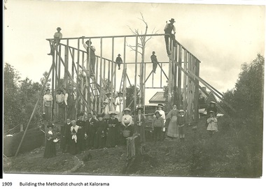
Photograph, Building the Methodist Church at Kalorama, 1909
The Methodist Church was built in 1910 by volunteer labour. Mainly through the efforts of the daughters of Eliza Hand and their families - the Jeeves, Walkers and Badenhops. (Lundy-Clarke manuscript)Local residents working to erect the frame of the Methodist Church on the Main Road (Ridge Road) at Kalorama. Eight workmen are on the frame with fifteen well dressed residents standing in front. 1910. Image received as a digital jpeg.Printed on front of photo: 1909 Building the Methodist Church at Kalorama church, kalorama methodist church, methodist church -
 Ringwood and District Historical Society
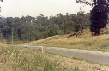
Photograph, View across junction of Wera (lower) and Manuelo (upper) Drives, North Ringwood showing how undergrowth had been cleared, February 1979
B552 N17 Part of a 51-photo record of the development of the "Kubis" Estate, Ringwood North, including road works to Debbie Place, Kubis Drive, Werac Drive, Manuelo Drive, Iluka Place and Glenvale Road. From the Jack Lundy Clarke collection. -
 Ringwood and District Historical Society
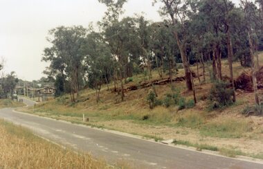
Photograph, Looking south up Werac Drive, North Ringwood past Manuelo Drive in February 1979
E552 N21 Part of a 51-photo record of the development of the "Kubis" Estate, Ringwood North, including road works to Debbie Place, Kubis Drive, Werac Drive, Manuelo Drive, Iluka Place and Glenvale Road. From the Jack Lundy Clarke collection. -
 Ringwood and District Historical Society
Photograph, Looking north down Werac Drive, North Ringwood with lake headwater's site behind light standard on left in February 1979
B552 N19 Part of a 51-photo record of the development of the "Kubis" Estate, Ringwood North, including road works to Debbie Place, Kubis Drive, Werac Drive, Manuelo Drive, Iluka Place and Glenvale Road. From the Jack Lundy Clarke collection. -
 Ringwood and District Historical Society
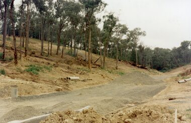
Photograph, The unfinished section of Debbie Place, North Ringwood in February 1979
E552 N23 Part of a 51-photo record of the development of the "Kubis" Estate, Ringwood North, including road works to Debbie Place, Kubis Drive, Werac Drive, Manuelo Drive, Iluka Place and Glenvale Road. From the Jack Lundy Clarke collection. -
 Ringwood and District Historical Society
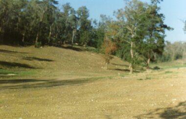
Photograph, Site of the main body of Loughnan's Lake, North Ringwood on 10 June 1978. the rope tree was on the slope, far left
E550 N6 Part of a 51-photo record of the development of the "Kubis" Estate, Ringwood North, including road works to Debbie Place, Kubis Drive, Werac Drive, Manuelo Drive, Iluka Place and Glenvale Road. From the Jack Lundy Clarke collection. -
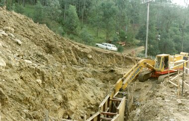 Ringwood and District Historical Society
Photograph, Kubis Estate, North Ringwood on 16 June 1978, using the Kato as a crne to de-water final trench
E550 N9 Part of a 51-photo record of the development of the "Kubis" Estate, Ringwood North, including road works to Debbie Place, Kubis Drive, Werac Drive, Manuelo Drive, Iluka Place and Glenvale Road. From the Jack Lundy Clarke collection.