Showing 10184 items
matching dandenong
-
 Bendigo Historical Society Inc.
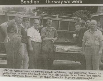
Newspaper - JENNY FOLEY COLLECTION: HEROES
Bendigo Advertiser '' The way we were'' from Wednesday, March 24, 2004. Heroes: Golden Square volunteer fire brigade in February 1962, after fighting blazes in the Dandenongs in which nine people died. From left: Captain Harley Brown, Ted Hocking, Bendigo mayor Dick Turner, Neill Tarr, Rupert Brown, Len Doye and Albert Naughdort. The clip is in a folder.newspaper, bendigo advertiser, the way we were -
 Mt Dandenong & District Historical Society Inc.
Photograph, Site of Kyeema Aircraft Crash, 1978
Woman looking down slope towards the actual site of the Kyeema aircraft crash which occurred on October 25th, 1938. The Douglas DC-2 Kyeema, operated by Australian National Airways, was en-route from Adelaide to Melbourne when it overshot Essendon Airport by 20 miles. Descending in thick cloud, it crashed into the western face of Mt Dandenong, killing all 18 occupants.air crash, kyeema, mt dandenong -
 Ringwood and District Historical Society
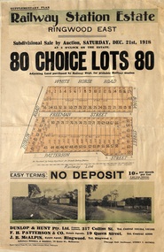
Flyer, Subdivisional Auction Sale Brochure, Railway Station Estate, Ringwood East, Vic. - 1918
Advertisement for subdivisional auction sale of 80 residential allotments on Saturday, 21st December, 1918, including terms of sale, subdivision layout, and nearby location photographs.Subdivision includes Mount Dandenong Road (incorrectly shown as White Horse Road), Dublin Road, Freeman Street, Bona Street, and Patterson Street. Local Agent - J.B. McAlpin, Telephone Ringwood 7. -
 Federation University Historical Collection
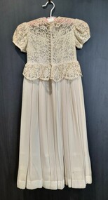
Clothing - Flower Girl Dress, Edith Alice Watson, Flowergirl Dress by dressmaker Alice Watson, 1952
Dress worn by Alison Watson at the wedding of Angela and Ewan Costain in 1952. Angela was a teacher at Murtoa Primary School. The outfit which included a bonnet and muff was made by Alice Watson, dressmaker, Murtoa. .1 Back and front of flower girl dress. .2 Bonnet displayed on a velvet covered stand. .3 Photograph of bride and flower girl.3 Inside front presentation folder: Best wishes, - Angela and Ewen (Costain) Flower girl Alison Watson (Jobe) Under photograph, bottom L 1952; bottom R Athol Adams Dandenong flower girl dress, alice watson, alumni -
 Eltham District Historical Society Inc
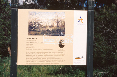
Slide - Photograph, The Orchard, May Vale (c.1904), Heidelberg School Artists Trail, Diamond Creek, c.Nov. 2001
The Heidelberg School Artists' Trail extends from Heidelberg through Eltham and Warrandyte and to the Dandenongs. It features signs depicting paintings of artists in the location in which they were painted. Part of a slide show presentation "A Trip Down the Diamond Creek" by Russell Yeoman to the Eltham District Historical Society meeting of 14 Nov. 200135mm colour positive transparency Mount - Black and Whiteart in public places, diamond creek, heidelberg school artists trail, public art, sign, may vale, the orchard -
 Greensborough Historical Society
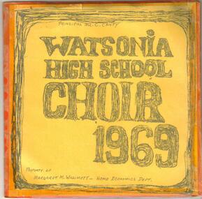
Sound Recording, Watsonia High School Choir 1969, 1969_
45rpm record created to raise funds on behalf of the WHS Choir. Arranged by WHS music teacher David Kefford. Proceeds from the sale of the record assisted in the WHS Choir taking part in the 1969 Royal South Street Competitions in Ballarat. Other events in 1969 included Dandenong Choral Festival and Heidelberg Festival.A lasting record of the school choir in 1969.45rpm music record recorded at All Saint's Church of England, Greensborough in 1969. Includes cover with names of students, one extended play record and photograph of students in choir.Tracks included 1: Ave Verum Corpus (Mozart), 2: Panis Angelicus (Franck) and on the B Side: 3 Hungarian folk songs (Matyas & Seiber)watsonia high school, watsonia high school choir, choirs, david kefford -
 Mt Dandenong & District Historical Society Inc.
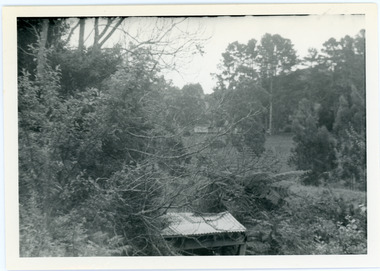
Photograph, View from George Barber's Home To His Stables
John Lundy-Clarke grew up in the Kalorama/Mt Dandenong area and later in life (1972-74) began to write a comprehensive history of the area working from an original settlement map in an effort to cover all areas. This photograph was taken by John Lundy-Clarke in 1973 to show changes to the environment sine 1905.Black and white photograph with tangled bush and small shed in foreground looking towards a cleared area. Handwritten description on reverse written by John Lundy-ClarkeView from Barbers drive to his stables close to where 1905 picture was taken. Stables in foreground. Looking towards Gap. Taken JLC November 1973.barbers road, john lundy-clarke, kalorama -
 Greensborough Historical Society
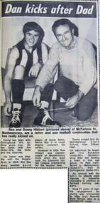
Newspaper - Newspaper Clipping - Digital Image, Diamond Valley News, Dan kicks after dad, 23/06/1970
Former Collingwood Football Club player Danny Hibbert of Montmorency laces up with the help of his father Ron. Hibbert was at Collingwood for three seasons. During the 1969 season, he scored five goals in a win over Geelong. Later, in the 1970s, he played with Dandenong and won the J.J. Liston Trophy in 1976.Digital copy of newspaper articlemontmorency - people, hibbert family, danny hibbert, australian rules football -
 Ringwood and District Historical Society
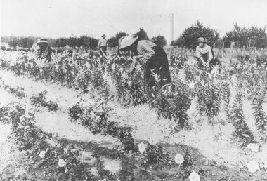
Photograph, Gathering Lancifolium Lilies and Queen Victoria Roses at Mr. John Hill's Nursery, Ringwood. 1905
Black and white photograph (2 copies)Typed under photograph: Gathering Lancifolium lillies and Queen Victoria roses at Mr John Hill's nursery, Ringwood. Typed below heading of one copy- "Mr. J. Hill's Nursery, Mt Dandenong Rd, Ringwood East. 1905. Written on back of photograph: "Hill Bros. Nursery 1905. (Mr. John Hill and daughters). Mt Dandenong Rd Ringwood East." Additional words- "Note Chimney stack (125' ?) from one of Ringwood brickworks on Dublin Rd. -
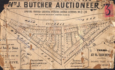 Ringwood and District Historical Society
Poster - Land Sale, Wm J. Butcher, Auctioneer - Albert Park Estate, Ringwood - c.1890
Central section of land sale subdivision advertisement glued to heavy cardboard backing. Photocopied SLV image of original advertisement shows map of 117 allotments for sale in Main Lilydale Road (later Old Lilydale Road), Wandin Road (later Mount Dandenong Road), Joseph Street, Dynes Street, Albert Street (later Wyrunga Street) and Government Road (later Carcoola Road), Ringwood East.Solicitors - Jenningw & Wright, Queen Street. Surveyors - J.&H. Tarrant, Elizabeth Street. Terms £2 10s cash deposit, balance three years at six per cent. -
 Melbourne Tram Museum
Album - Robert Thomson Slide Collection, "Melbourne 1968"
4182 - Box 2 - Melbourne 1968 (RT033-054) RT033 Dandenong Rd - tram 870 - "St Kilda Bch - Balaclava Rd" - route 69 RT034 St Kilda Rd - tram 262 - "South Melb Beach" - route 2A RT035 Sth Melb Beach Ter - tram 262 - "City" - route 2A RT036 Wallen Rd - tram 923 - "City" - route 70 RT037 Dandenong Rd - tram 438 - "Malvern - Burke Rd" - route 5 RT038 Batman Ave Ter - tram 851 - "Wattle Park Warrigal Rd" - route 70 RT039 Batman Ave - tram 864 - "City" - route 70 RT040 Princes Bridge - tram 874 - "Moreland" - route 15 RT041 E Brunswick Ter - tram 1038 - "City - Spencer St" - route 96 RT042 Victoria Pde - tram 673 - "South Melb & St Kilda Beach" - route 12 RT043 Dandenong Rd at St Kilda Junction? RT044 Dandenong Rd at St Kilda Junction? RT045 St Kilda Jct? RT046 Wellington St - tram 811 - "City" - route 64 RT047 St Kilda Jct RT048 St Kilda Jct? - trams 968 & 902 - "Carnegie" & "City" route 4 RT049 St Kilda Jct? - trams 968 & 902 - "Carnegie" & "City" route 4 RT050 Carnegie Single Line - tram 774 - "City" - route 4 RT051 Nth Fitzroy Depot - buses RT052 Wattle Park Single Line - tram 823 - "Wattle Park Elgar Rd" - route 70 RT053 Wattle Park Single Line - tram 371 - "Wattle Park Elgar Rd" - route 70 RT054 Essendon Reserved Track - tram 449 - "City" - route 59Demonstrates the work of Robert Thomson in photography, collection and/or production of slidesAssembled album in a black presentation folder of 22 colour slides, collected or produced by Robert Thomson. All photographs have been scanned and placed on the Museum's G drive. A list of all photographs with details has been compiled. melbourne, tramways, trams, track construction -
 Royal Australian and New Zealand College of Obstetricians & Gynaecologists (RANZCOG)
Dr Wansbrough nipple shields, with manufacturer's box
Nipple shields were known from the sixteenth century and have been made from a variety of materials. Stays and corsets of the seventeenth and eighteenth centuries resulted in much nipple inversion and were often used day and night. Similar examples to this are held in the University of Melbourne Medical History Unit collection, and by the Dandenong Historical Society.Two moulded lead nipple shields in circular cardboard box. The box is lined with pink paper, and carries a quoted excerpt from Dr Wansbrough on the base. There are printed directions for use inside the box.breast feeding -
 Glen Eira Historical Society
Article - St Mary The Virgin, Kooyong Road, South Caulfield
Four articles by Dulcie Cousins, Joan Millar, Jim Millar and Grace Hocking. They each give a brief insight in what they enjoyed about being a member of the Kooyong Road Church. From the social and sports clubs, anniversary occasions, picnics in the Dandenongs, church on Sunday nights, the passing parade of ministers and the general church community they embraced.bundeera road uniting church, cousins dulcie, cousins rowley, kooyond road, kooyong road church, lund amy, south caulfield uniting church, truscott. mr, millar joan, kennedy duncan rev., cousins beth, millar jim, gray helen, cousins john, hocking grace, gray christie, st mary the virgin -
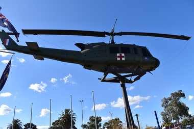 Dandenong/Cranbourne RSL Sub Branch
Vehicle - Helicopter (Dustoff)!!
Significant historical importance during the Vietman War-era. These HUEY'S were responsible for saving thousands of injured and distressed military personnel. Dustoff was donated to the Dandenong RSL by the United States in September 2003. Dustoff is a Iroquois UH - 11v ( a modified UH - 1D ) she was fully restored when donated. They were a highly manoeuvrable aircraft.Very important. Huey saved lives. Dustoff is a local attraction bringing many people to view it. Ex U.S Military helicopter. Dustoff or CASEVAC - fitted out to evacuate wounded soldiers during the Vietnam War. These helicopters were commonly called "Hueys".Large Red Cross on front. Left hand side - UNITED STATES ARMY 73 - 21763 USAR. Red Cross with 763 enclosed and small Vietnamese Flag. Right hand side - Red Cross with 763 enclosed small Australian Flag RAAF with Kangaroo. Tailfin RHS A2-767 over red, white and blue flag representing New Zealand. -
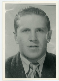 Mt Dandenong & District Historical Society Inc.
Photograph, Alan Price
John Lundy-Clarke grew up in the Kalorama/Mt Dandenong area and later in life (1972-74) began to write a comprehensive history of the district working from an original settlement map in an effort to cover all areas. Alan Price was the son of Edward John Price and Myra (nee Wilson) Price. He had a brother Edward Joseph 2nd (Teddie). Alan and Teddie were the grandsons of early settlers Edward Joseph and Annie (nee Ross) Price. Alan Price worked at his brother's depot in Ringwood, in charge of mechanical equipment. He rode to and from work on his motorbike. Alan was killed in a motorbike accident on his way home from work in 1971. Alan married Patricia Guerin in 1960. They had five daughters and one son. The family had a house on part of Lot 5 facing Mt Dandenong Road.Black and white close up of man in suit and tie. Reverse of photograph has handwritten description by John Lundy-Clarke. Alan Price 1969. Son of Edward John Price and Myra nee Wilson. alan price, patricia guerin, edward joseph (teddie) price, edward john price, myra price, myra wilson, edward joseph price, annie price, annie ross, kalorama, accident -
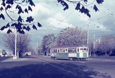
 Ballarat Tramway Museum
Photograph - Black & White Photograph/s, 1970's?
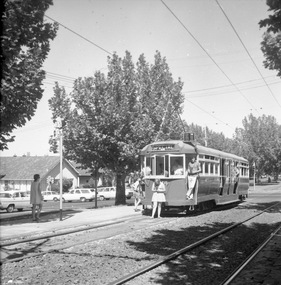
Black and white photograph of L 104 in Dandenong Road Prahran, at tram stop 35 while on a special tour with a signalised intersection behind - Melway shows it as Orrong Road, Prahran. Tram showing destination of "SPECIAL". Possibly taken during the mid 1970's - see also item 1314, possibly on the same tour given the hair styles and skirt lengths. See Melway Melbourne Street Directory, 21st edition.trams, tramways, l class, dandenong road, melbourne, mmtb, tram 104 -
University of Melbourne, Burnley Campus Archives
Document, Buildings - General, 1983-1988
archive, victorian college of agriculture and horticulture burnley, conservation trust, buildings -
 Melbourne Tram Museum
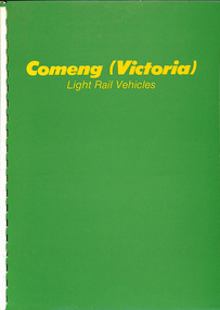
Document - Report, Commonwealth Engineering - Comeng, "Comeng (Victoria) Light Rail Vehicles", c1987
Report - 14 colour A4 sheets + two card covers bound with white comb binding titled "Comeng (Victoria) Light Rail Vehicles", detailing the trams or light rail vehicles built for Melbourne. Details the company, its capability, plant in Dandenong, Design using CAD systems, tram production photographs, details of the B class, A and Z3 along with description and engineering details including drawings of each unit.trams, tramways, comeng, commonwealth engineering, b class, a class, z3 class, tram bodies, bogies, light rail, tramcars -
Glen Eira Historical Society
Article - Toyne, Gilbert
This file contains two documents. Typewritten letter from Peter Cuffley providing background on Gilbert Toyne, manufacturer of the QUICK-DRY Rotary Clothes Hoist in Dandenong Road. Envelope attached. Computer print-out on HUNG OUT TO DRY the book, written by Peter Cuffley. Interview with him on ABC Ballarat Radio. Small black and white photo of hoist.toyne gilbert, quick dry rotary clothes hoist, toyne trading co., farrier, vernegie, ellimatta road, morton road, caulfield racecourse -
 Dandenong/Cranbourne RSL Sub Branch
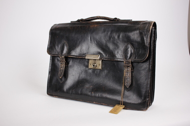
Equipment - Brief Case
This briefcase belonged to Tom Aldrick, SERN VX91434. Tom was born in WARRAGUL VIC. He enlistmented in ROYAL PARK VIC. His next of kin was - ALDRICK J. The briefcase was captured from a Japanese soldier by HQ Company 2/14th Infantry Battalion, as shown by the Japanese inscriptions. The case had some documents inside. It was donated to Dandenong RSL in 1983.Black leather brief case with carry handle on top. It has one central metal slide locking facility. Has two buckles on either side of central lock to secure briefcase. There are a couple of Japanese words inscribed with texta on the inside of the brief case. There is also the name "T & R.E. Aldrich Bayles" written with biro the inside of the briefcase. -
 Melbourne Tram Museum
Pamphlet - Commonwealth Engineering, Commonwealth Engineering - Comeng, 1975
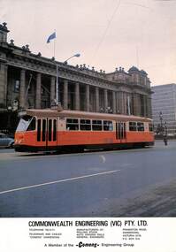
Photograph of then new Melbourne tram Z1 outside Parliament House, Melbourne turning from Spring St, soon after the launch of the tram on 30/4/1975. Provides information on Commonwealth Engineering, (Comeng), the company who made the bodies in Dandenong. This location continues to provide trams for Melbourne, though the manufacturer has changed names a number of times.Yields information about the manufacturer of the Z class trams and the appearance of the first tram of the class when new.Pamphlet - Commonwealth Engineering - tramcar Z1 - company details and a photo or Tramcar Z1 outside Parliament House. Printed on gloss paper.trams, tramways, new trams, comeng, z class, z1, spring st, parliament house, commonwealth engineering -
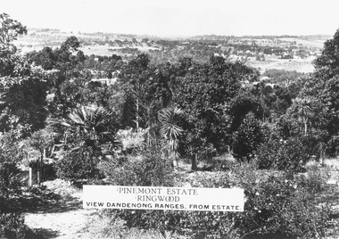 Ringwood and District Historical Society
Photograph, Two images of view from Pinemont Estate, Loughnans Hill, looking east, c1930
Black and white photograph of view. Trees and bushes in foreground, orchards and mountains towards background. (2 copies)Typed on photograph, "Pinemont Estate, Ringwood. View Dandenong Ranges, from estate". Typed below photograph, "View from Loughnans Hill, looking east, c1930. Club Hotel can just be seen top right corner". -
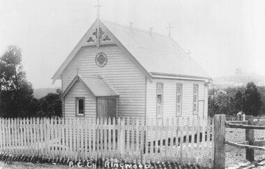 Ringwood and District Historical Society
Photograph, Roman Catholic Church, Ringwood 1915 (Built 1893)
Black and white photograph of small wooden church.Typed below photograph, "Roman Catholic Church - Whitehorse Rd. opposite Mt. Dandenong Rd. intersection - 1915" Written on back of another copy: Built 1893 at (one stage) in grounds of R.C. School. Photographer Brian Pump. -
Glen Eira Historical Society
Ephemera - Restaurants-Glen Eira
This file contains one item: 1/A pamphlet for Mandarin Court Restaurant, 557 Centre Road Bentleigh, and its sister restaurant in Dandenong, both owned by Michael and David Chew. The pamphlet contains the history of Mandarin Court Restaurants, maps of its locations, opening hours, and its takeaway menu. A special offer is included stamped as valid until 15/08/1987.mandarin court restaurant, chew michael, chew david, bentleigh coppins reception, centre road, bentleigh, restaurants -
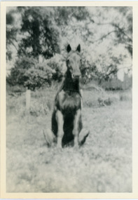 Mt Dandenong & District Historical Society Inc.
Photograph, Logan's Trick Horse
John Lundy-Clarke grew up in the Kalorama/Mt Dandenong area and later in life (1972-74) began to write a comprehensive history of the area working from an original settlement map in an effort to cover all areas. This photograph shows the 'trick horse' belonging to Robert Logan. Robert Logan settled on Lot 28 in 1896 and worked it until his death in 1936.Black and white photograph on a horse sitting in grass. Handwritten inscription on reverse by John Lundy-Clarke.1920 Logan’s trick horse on LOT 28 SECTION 1robert logan, logan, horse, kalorama, john lundy-clarke -
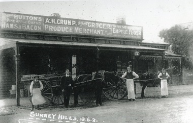 Surrey Hills Historical Society Collection
Photograph, Alfred Henry Crump's grocery and produce store in Canterbury Road, Surrey Hills, 1913, 1913
This building was adjacent to Surrey Lodge, on the corner of Canterbury and Union Roads. The store was established by George Sim in 1885 and in 1889 he set up the 1st Surrey Hills Post Office here. The business was bought by Alfred Claude Geer in 1909; the Camberwell Rate books show that from 1913 Geer remained owner but the business was occupied by Alfred Henry Crump; confirmed by electoral rolls for 1913-1918. Prior to moving to Surrey Hills, Alfred was a grocer in Dandenong. Otto Kuhn was Alfred Crump's store manager and may have taken this photo. Alfred married Hazel May Ordish in 1913 in Dandenong. The marriage notice in the Argus on 5 July indicates that the couple resided at 'Hazeldene' in Leopold Crescent. Moran and Cato had already established a business across Union Road from McNeill's Hotel and in time this business and one other grocery store opposite closed as a result.Black and white photo of A H Crump's grocery and produce store in Canterbury Road, Surrey Hills in 1913. There are 4 men and 2 horse-drawn carts in front of a timber single-storey building with a verandah with a corrugated-iron roof. At least one of the carts has "A H CRUMP" painted on the side. Three of the men are wearing long white aprons; the other, AH Crump, is in a suit. Advertising signs on the hoardings are for Huttons hams and bacon and Empire flour. Cadbury's cocoa is advertised on the shop window. The hoarding above the verandah also indicates that the business was established in 1884. There is a block-fronted single storey house with a picket fence adjacent to the shop, to the east along Canterbury Road."SURREY HILLS.13.6.2" diagonally across the bottom LH side of the photo.post offices, grocers, shops, businesses, horse drawn vehicles, alfred henry crump, alfred crump, alfred claude geer, alfred geer, otto kuhn, george sim, hazel may ordish, hazel may crump -
 Melbourne Tram Museum
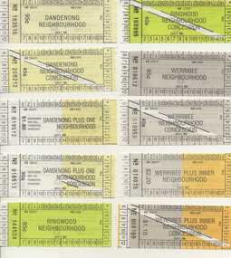
Ephemera - Ticket/s, Public Transport Corporation (PTC), Set of 21 The Met Neighbourhood tickets, 1989
Set of 21 The Met Neighbourhood tickets - May to August 1989. Conditions of use printed on rear. Printed on white paper. 1. Dandenong Neighbourhood - 183516 2. Ditto concession - 208212 3. Dandenong plus one Neighbourhood - 019512 4. Ditto concession - 018513 5. Ringwood Neighbourhood - 144534 6. Ditto concession - 168995 7. Werribee Neighbourhood - 018612 8. Ditto concession - 018959 9. Werribee plus inner Neighbourhood - 014015 10. Ditto concession - 008168 11. Ringwood plus one Neighbourhood - 024729 12. Ditto concession - 0198882 13. Inner Neighbourhood - B089291 14. Ditto concession - A088033 15. Inner plus one Neighbourhood - 359210 16. Ditto concession - 224012 17. Broadmeadows Neighbourhood - 044541 18. Ditto concession - 038635 19. Broadmeadows Plus Inner Neighbourhood - 034587 20. Ditto concession - 024933 21. Greensborough Plus One Neighbourhood concession - 003016trams, tramways, tickets, the met, ptc, neighbourhood tickets -
 City of Moorabbin Historical Society (Operating the Box Cottage Museum)
Photograph - Plateway (Wheelway) Steel, circa 1885
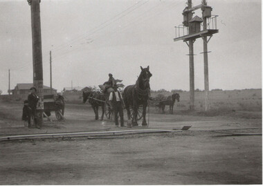
By the later 1800s the dirt roads in the then out-lying areas of the City of Moorabbin became dangerous, and almost impassable due to huge potholes and muddy swampy areas. The heavily laden market gardener’s carts regularly broke axles and wheels, and horses foundered on their way to the Melbourne markets. Even worse, the heavier “iron maidens”, carrying their malodorous loads of sewage from Melbourne’s inner suburbs for dumping in the outlying areas of the City of Moorabbin, also got bogged in the mire. It was decided that a practical solution to this problem was to install a metal plateway on the side of the problematic roads. In about 1887 the Moorabbin Shire Centre Road, in the Brighton East area, two parallel metal rails were installed so that the wheels of carts could run along smoothly, the horse travelled in the filled, middle area between the rails. Point Nepean Road plateway was removed in 1930 and Centre Dandenong Road plateway was removed in 1934-35. The worn plateway along Centre Road, East Brighton (now known as Bentleigh), was gradually taken up in several pieces, commencing in the the1920s, when its condition deteriorated and it caused a hazard to bikes, pedestrians, motor-cycles and the few early cars. The early steel plateway, constructed by David Munro, and opened on 23rd March 1885 by Thomas Bent, was built along Nepean Highway, between Asling St. and Bay St. The Point Nepean Track was subsequently extended into Moorabbin with branches along Centre, Cumins, South, Wickham, and Keys Roads, the total length was 13 miles. In 1908-1909 plates were laid along Centre Dandenong Road to Ross Street Bentleigh This innovative solution proved successful and was used until gradually the main roads were upgraded, and motorised vehicles started to appear. Two parallel metal rails were installed in the right hand side of a few main roads in the Shire of Moorabbin so that the wheels of heavily-loaded market gardener's carts on their way to markets in Melbourne could run along smoothly. The horse pulling the carts travelled in the filled, middle area between the rails. The Steel Plateway was constructed by David Munro, and opened on 23rd March 1885 by Thomas Bent. The wheelway first only ran along Nepean Highway, but it soon extended from Centre Dandenong Road, along Nepean road to its junction with Chapel Street, St Kilda. Later branch lines were built along Centre Road, Bentleigh as far as Warrigal Road and, according to early photographs, along Wickham Road Moorabbin as well. This innovative solution proved successful and was used until gradually the main roads were upgraded, and motorised vehicles started to appear. There was a problem with the wheelway : there was only a single set of rails and this was established on the right-hand side of the Nepean Road, travelling towards the city. Traffic FROM the city travelled on the correct or left-hand side of the road. The exception to this rule was the malodorous iron-clads, heavily riveted iron carts, generally travelling in convoy, carrying several tons of human effluent out of Melbourne to be trenched-in in the sandy soil of the Moorabbin district. Moorabbin City Council donated and installed a small section of Plateway at Box Cottage Museum in 1984melbourne, brighton, moorabbin, roads, plateway, wheelway, transport, st kilda, bent thomas, munro david, market gardens, steelway, carts horse-drawn, iron maidens, point nepean track -
 Ringwood and District Historical Society
Photographs, Rebboch, Myil, Restaurants and cafes in Ringwood/Ringwood East photographed by Myil Rebboch - 1999-2000, 1999 - 2000
Bundle of 21 photographs in Agfa folder. Restaurants and cafes in Ringwood/Ringwood East 1999 - 2000. Taken by Myil Rebboch. Smorgy's - corner of Oban Road and Maroondah Highway (3211_Smorgy's_001) Red Rooster - corner of Beaufort Road and Maroondah Highway (3211_Red Rooster_002) Kublai Mongolian - corner of Beaufort Road and Maroondah Highway (3211_Kublai_003) Nikos Greek Tavern - Mt Dandenong Road opposite Carcoola Road (3211_Nikos Greek Tavern_004) Turtle Den - Railway Avenue Ringwood East (3211_Turtle Den_005) Maroondah Sporting Club - Mt Dandenong Road (3211_Maroondah Sporting Club_006) Hungry Jack's - corner of Mt Dandenong Road and Maroondah Highway (3211_Hungry Jack's_007) Daisey's Hotel - Mt Dandenong Road (3211_Daisey's Hotel_008) Lone Star - Maroondah Highway (3211_Lone Star_009) Canton - Murray Place (3211_Canton_010) Cafe Thirty-Five - Ringwood Street (3211_Cafe Thirty-Five_011) Cafe Ringwood Market (3211_Cafe Ringwood Market_012) Phoolwari - Eastland (3211_Phoolwari_013) Jamaica Blue - Eastland (3211_Jamaica Blue_014) Gourmet - Eastland (3211_Gourmet_015) Muffin Break - Eastland (3211_Muffin Break_016) Food Terrace - Eastland (3211_Food Terrace_017) Croissant - Eastland (3211_Croissant_018) Emerald Hill - Eastland (3211_Emerald Hill_019) Fasta Pasta - Eastland (3211_Fasta Pasta_020) Eating In - Eastland (3211_Eating In_021) -
Melbourne Tram Museum
Pamphlet, Minister for Public Transport, "Melbourne's new G class tram", 8/11/2024
Pamphlet titled "Melbourne's new G class tram" - an update on the design and construction, including an aerial view of the new Maidstone depot following a Ministerial visit to the Alstom plant on 8/11/2024 - "Minister for Public and Active Transport Gabrielle Williams today visited Alstom’s factory in Dandenong to announce the start of major works on the Next Generation Trams Project." See htd7796i2 for the Press Release.Yields information about the new G class trams and the new Maidstone depot.Pamphlet - 4 sheets when printedtramcars, new trams, g class, alstom, press release