Showing 629 items matching " land surveys"
-
 Eltham District Historical Society Inc
Photograph - Digital Photograph, Marguerite Marshall, Hawthorn hedges, Eltham-Yarra Glen Road, Kangaroo Ground, 3 October 2006
Hawthorn hedges are important reminders of Kangaroo Ground's Scottish heritage. They are Registered on the Victorian Heritage Register. They are "historically significant because the planting of hawthorn hedges reflects the adoption of Eurorpean farming techniques by the Kangaroo Ground population in the period following settlement and because the grid pattern of paddocks that the Hawthorn hedges define is very different to today's farm landscapes." Covered under Heritage Overlay, Nillumbik Planning Scheme. Published: Nillumbik Now and Then / Marguerite Marshall 2008; photographs Alan King with Marguerite Marshall.; p21 Hawthorn hedges bordering Kangaroo Ground’s gently rolling farmlands are important reminders of its Scottish heritage and are rare so close to Melbourne.1 As early as the 1840s newly arrived farmers from Scotland planted hawthorn hedges around their properties, to protect crops from the numerous kangaroos and wallabies. Many of these hedges survive today. These farmers had the good fortune to settle some of the most fertile land available for cropping in the Colony of Victoria. At that time the black volcanic soil could sustain an amazing two crops a year. By the mid 1850s, 500 acres (202ha) of wheat were growing in Kangaroo Ground. But the crops were threatened by kangaroos, which were so plentiful, that Surveyor-General, Robert Hoddle, named the district Kangaroo Ground in 1838. As post-and-rail fences proved inadequate barriers for the bounding kangaroos, the Scots planted hawthorn hedgerows as they had done in Scotland. Some also used the hedges to net birds, presumably for the table. Interestingly the farmers in the bordering townships of Panton Hill and Christmas Hills, did not plant hawthorn hedges around their properties. Perhaps it was because by the time they settled in the 1860s and 1870s most of the wildlife had been gunned down by residents.2 The canny Scots planted the hedges on public land outside their own farms, as the hedgerows could spread to about five yards (five m) in width. With this impenetrable barrier Kangaroo Ground’s industrious farmers flourished to gain the economic power that saw the Shire of Eltham governed from Kangaroo Ground for 79 years (1858-1937). The Scots jealously guarded their land, so hard to get in Scotland. That is why they refused to release any of it ‘for local roads to follow easier grades as was the case in surrounding districts where roads generally followed ridgelines or streams’.3 Instead the roads were built in accordance with the magnetic bearings of their first survey in 1847 whether that suited the steep topography or not. This could force traffic to diverge when wet through Greensborough and Diamond Creek. Until 1921, the Eltham-Yarra Glen Road beside Wellers Restaurant, ‘dipped down into the upper reaches of Stony Creek’.4 Later some corners were compulsorily cut for the increasing motor traffic. As late as the 1960s, corners were cut to form sweeping curves above and alongside the Kangaroo Ground Cemetery and opposite the Emergency Operations Centre. In the latter case, the farmers – understanding their hedgerows as important heritage – insisted upon their reinstatement to conform to the altered road alignment. Kangaroo Ground’s ancient manna gums also point to the district’s history and to that of the hedgerows. The Aboriginal people had transformed the original forests into grasslands with the fires they lit to attract kangaroos, (which the Scots were to exclude by planting hedgerows). But the Wurundjeri hunters left the gums (Eucalyptus vimminalis cygnetensis), on the grasslands as ‘stalking trees’ to hunt kangaroos. The hawthorn hedges in Kangaroo Ground were neglected for around 60 years from about the middle of the 20th century. Bushfires had created gaps and the hedgerows were not trimmed. Then in late 2005, local historian Mick Woiwod, formed a group to lobby the Nillumbik Shire to restore the hedges, which could last for many centuries. Some hedges in parts of Britain date back to AD 800.5 Although the original Scottish farmers have gone, the hedges are a reminder of when they flourished in the district, which has changed little in 150 years.This collection of almost 130 photos about places and people within the Shire of Nillumbik, an urban and rural municipality in Melbourne's north, contributes to an understanding of the history of the Shire. Published in 2008 immediately prior to the Black Saturday bushfires of February 7, 2009, it documents sites that were impacted, and in some cases destroyed by the fires. It includes photographs taken especially for the publication, creating a unique time capsule representing the Shire in the early 21st century. It remains the most recent comprehenesive publication devoted to the Shire's history connecting local residents to the past. nillumbik now and then (marshall-king) collection, eltham-yarra glen road, hawthorn hedgerow, kangaroo ground -
 Eltham District Historical Society Inc
Photograph - Digital Photograph, Alan King, St Margaret's Anglican Church, Pitt Street, Eltham, 30 January 2008
... of "special surveys". After this land passed out of his hands, Dendy... of "special surveys". After this land passed out of his hands, Dendy ...St Margaret’s Church of England was officially opened on December 12, 1861. It is the oldest intact church building in Eltham. At the time it was known as Christ Church until its consecration in 1871, when it was completely free of debt (£1,700 for the church and parsonage) despite the district’s poverty. This was largely due to the free labour and materials, including locally made bricks donated by local artisans and others. The church is historically significant because it is the oldest church in the former Shire of Eltham and has associations with the philanthropist and founder of Brighton, Henry Dendy (who donated the land on which the church is built), the architect Nathaniel Billing and the prominent local builder, George Stebbing. The church is architecturally and aesthetically significant because it is constructed in the Gothic Revival style with several stained-glass windows of various dates and is also a very early use of polychromatic brickwork in Victoria. Billing was one of the first Melbourne architects to employ polychromatic brickwork and an important early architect. The rear wall was intended to be temporary. A major feature of the design is the large buttresses with long, steeply graded upper faces. The overall design is well proportioned with the surface brick patterns relieving an otherwise austere design. The church is spiritually and socially significant because it has been an important place of worship for the people of Eltham for almost 150 years. The land on which the buildings stand was donated by Henry Dendy. Dendy arrived in Melbourne in 1841 after purchasing in England eight square miles at Brighton under the system of "special surveys". After this land passed out of his hands, Dendy moved about Victoria, visited England, then returned to settle in Eltham where he purchased a flour mill. Dendy chaired the meeting held in 1860 “for the purpose of devising such means as may be expedient for the establishment of a Church of England in the township of Eltham”. He became chairman and treasurer of the church committee. Unlike the establishment of many early churches in Victoria where a vicar was appointed to a parish and later a permanent church was constructed, the population at Eltham initiated action to build a church. The nearest church at that time was at Heidelberg and the Eltham settlement was part of the parish of St Johns Heidelberg. Isolation and the tedious, time consuming journey between Heidelberg and Eltham resulted in the Eltham community taking its own action. The original vicarage (Dendy House) at the rear of the church is also an important part of the cultural significance of this place because it is connected to the church and the development of the Eltham area. Together, the church and the vicarage are aesthetically significant because they form a significant streetscape feature. The mud-brick community hall designed by Robert Marshall was added in 1978. In 2014 the original temporary rear wall was removed as part of a modern extension designed by Architects Atelier Wagner and constructed by Conrad Construction and Management. Covered under Heritage Overlay, Nillumbik Planning Scheme. National Trust of Australia (Victoria) State significance Victorian Heritage Published: Nillumbik Now and Then / Marguerite Marshall 2008; photographs Alan King with Marguerite Marshall.; p67 St Margaret’s Anglican Church in Pitt Street, Eltham, which officially opened on December 12, 1861, is the oldest intact church building in Eltham.1 With the nearby courthouse and police station, it was one of the first permanent community buildings in the district. The church and vicarage are on the Register of the Heritage Council of Victoria and the National Trust of Australia – Victoria. The church is important as an early example of polychrome brickwork by the notable architect Nathaniel Billings. It is also notable for its historic associations with the early settlement of the Shire of Eltham and its connection with Henry Dendy, Brighton’s founder.2 Henry Dendy, who lived in Eltham much longer than at Brighton, chaired the original meeting which planned the church, and he donated the half-acre (0.2ha) site. Dendy had arrived in Melbourne in 1841 after buying eight square miles (20.7sq km) at Brighton while in England. After this land passed out of his hands, he eventually settled in Eltham where he bought a flour mill, west from the corner of Main Road and Pitt Street (then called Brewery Lane). The vicarage was named Dendy House after him. The Eltham settlers were unusual in initiating the establishment of a church. Usually in Victoria a vicar was appointed to a parish and then a permanent church was constructed. But then, the nearest church was at Heidelberg, which was a tedious and time-consuming journey. St Margaret’s builder was a local, George Stebbing, who also constructed the former Methodist, later Uniting, Church at John Street and the Shillinglaw Cottage near Eltham’s Central Park. It is believed the first Anglican Bishop of Melbourne, Bishop Perry, dedicated the church. After the ceremony he joined in the festivities at the nearby pub and a bill was sent to the parish for teas taken there by the bishop with other participants. The first vicar was the Reverend Robert Mackie from 1864 to1866. St Margaret’s Church was originally called Christ Church until its consecration in 1871, when it was completely free of debt (£1700 pounds for the church and parsonage) despite the district’s poverty. This was largely due to the free labour and materials, including local bricks, donated by local artisans and others. St Margaret’s Church is in the Gothic Revival tradition with a buttressed nave, paired lancet windows, porch and bell-cote. It was the first polychromatic brick church in Australia, using softly contrasting coloured brickwork.3 Billing was one of the first architects to introduce polychrome brickwork into Melbourne. His original drawings for St Margaret’s survive in a folio of his architectural work. However the church’s brickwork is more subdued than in his drawings. About half the windows – those in clear glass with gold borders – are original. The stained glass windows were made much later, but the one behind the altar is thought to be the oldest in the Diamond Valley. It was to be temporary until the congregation could afford to extend the church. In the early 1960s the original cedar pews were replaced by blonde timber pews and the originals were sold to restaurants and to private individuals. Eminent local sculptor Matcham Skipper created a crucifix for the church. A major addition was made in 1978, when the weatherboard hall was replaced by a mud-brick hall. Made of local material, it was designed by local architect and a former shire president Robert Marshall. The mud-brick hall reflects the style of building in Eltham of the late 1970s and for which Eltham is well-known. Perhaps because its earthy tones blend with the surrounding environment, the hall sits well with the church building. St Margaret’s membership has included economist and ABC chairman, Richard Downing; political commentator, diplomat and academic, William Macmahon Ball; Eltham civic leader, Charles Wingrove; artist, Peter Glass; and Eltham’s first postmaster, Frederick Falkiner.This collection of almost 130 photos about places and people within the Shire of Nillumbik, an urban and rural municipality in Melbourne's north, contributes to an understanding of the history of the Shire. Published in 2008 immediately prior to the Black Saturday bushfires of February 7, 2009, it documents sites that were impacted, and in some cases destroyed by the fires. It includes photographs taken especially for the publication, creating a unique time capsule representing the Shire in the early 21st century. It remains the most recent comprehenesive publication devoted to the Shire's history connecting local residents to the past. nillumbik now and then (marshall-king) collection, eltham, st margaret's anglican church, st margaret's church, st margarets church hall, christ church -
 Bendigo Historical Society Inc.
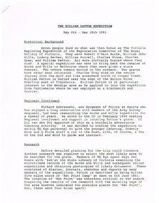
Document - THE WILLIAM PATTON Burke and Wills EXPEDITION MAY 4 - 19 1991
Typed notes on an expedition by Army personnel and Richard Zakrzewski to find the grave of William Patton who was buried near the edge of the Bulloo River Overflow east of Tibooburra. He was a member of the Burke and Wills Party. Notes mention planning for the expedition and what they did while they were there. C. E. Burgess WO2, the author of the notes.document, the william patton expedition may 4 - 19 1991, the victoria exploring expedition of the exploration committee of the royal society of victoria, robert o'hara burke, william john wills, ludwig becker, william purcell, charles stone, charles gray, william patton, richard zakrzewski, army survey regiment, burke and wills expedition, lt col van den tol, state library of victoria, land information centre bathurst, capt. coulthard, wo1 slater, wo2 burgess, sgt de grauw, lcpl blake, capt cuskelly, wo1 gillies, ssgt sustart, cpl colde, cpl south, lcpl northausen, spr linwood, wo2 graham, ssgt gowers, sgt marshall, cpl doyle, cfn ellis, spr reynolds, spr hilbig, pte mckersie, 10/27 rsar, clifton downs homestead, gwen smith, william patton memorial -
 Bendigo Historical Society Inc.
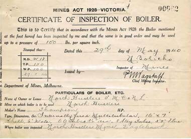
Document - MCCOLL, RANKIN AND STANISTREET COLLECTION: NORTH HUSTLERS GMC NL, 1934 - 1940
Document. Envelope contains: - Dept. of Lands and Survey Permissive Occupancy agreement & receipts, Fire Policy, Cert. of Inspection of Boiler, Insurance Policies, Crown Land Receipts. Right No. 4827 Eaglehawk. Pressure Gauge readings from Russell & Russell, manufacturer of Steam Vacuum and Compound Gauges dated 25th August 1939.McColl, Rankin & Stanistreetorganization, business, gold mine, mccoll, rankin & stanistreet, north hustlers gmc nl, gold mining, dept. of lands & survey permissive occupancy agreement, fire policy, state accident insurance mine policies -
 Bendigo Historical Society Inc.
Document - LANDS OFFICE, REPORTS OF SALES BY PUBLIC AUCTION BENDIGO DISTRICT
... Land sales northern victoria Lands Office land surveyed ...Document: green hard cover book with buff spine and corners. Contains details of public auctions of land in Bendigo and district. Entries are in chronological order of sales with sale advertisement attached to page. Includes Manangatang, Boort, Rushworth, Maldon, Heathcote, Castlemaine, Sea Lake, Avoca.Lands Officeland sales, northern victoria, lands office, land surveyed, land sold, public auction, country victoria -
 Bendigo Historical Society Inc.
Document - LANDS OFFICE: REPORT OF LAND SALES BY AUCTION 1881 - 1895, 1881 - 1895
... Land sales auctions Lands Office land surveyed land sold ...Document: LANDS OFFICE: REPORT OF LAND SALES BY AUCTION 1881 - 1895 Green hard cover book with buff spine and corners. Contains reports of sale by public auctions of crown lands in Charlton, St. Arnaud, Avoca, Donald, Wedderburn, Wycheproof.Lands Officeland sales, auctions, lands office, land surveyed, land sold -
 Ringwood and District Historical Society
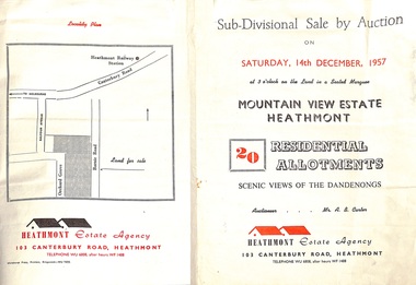
Flyer - Land Sales Brochure, Sub-Divisional Sale by Auction - Mountain View Estate, Heathmont, Victoria - 1957
Bi-fold pamphlet advertising auction of 20 residential allotments on Saturday, 14th December, 1957, with description of services available and finance terms. Subdivision inclues Orchard Grove and Barnic Road. Agent - Heathmont Estate Agency, 103 Canterbury Road, Heathmont, Telephone WU6808, after hours WF1488. Auctioneer Mr. A.B. Carter. Accompanying Parish of Ringwood survey map with cardboard backing - Part of Crown Allotment 14B, includes handwritten price notations for each allotment. -
 Bendigo Historical Society Inc.
Document - LANDS OFFICE - PLANS FORWARDED TO CROWN LANDS OFFICE, 1.9.1871 to 5.4.1880
... Lands office Sandhurst Bendigo land sales land surveyed ...Document: hard cover journal, brown cover with darker tan spine. 239 pages. Contains index at front of journal. Listings of plans forwarded to Melbourne Crown Lands Office by Bendigo Office. Alphabetical listing in front followed by numbered pages with individual details. Parish, county, allotment, section, surveyor, date remarks.Lands Officelands office, sandhurst, bendigo, land sales, land surveyed, plans -
 Bendigo Historical Society Inc.
Document - LANDS OFFICE - CROWN LANDS SURVEYED AND SOLD - INDEX, 26.1.1857 - 1871
Document: hard cover journal, faded dark green cover with brown corners and spine. 193 pages filled out - LH page: Parish, town lands, suburban lands, country lands, total lands surveyed, date of survey RH page: date of sale, by auction, by selection, price per acre, total amount, name of purchaser. On spine ' 01, index book O'.Lands Officelands office, bendigo, sandhurst, crown lands sold, rural land. -
 Forests Commission Retired Personnel Association (FCRPA)
Beechworth FCV District office sign
This sign proudly hung outside the Forests Commission Victoria (FCV) Beechworth office which is now site of the Forestry Heritage Museum. The granite building in the Beechworth's historic precinct was once the Gold Warden's Office and is one of the town's original buildings. The FCV was the main government authority responsible for management and protection of State forests in Victoria between 1918 and 1983. The Commission was responsible for ″forest policy, prevention and suppression of bushfires, issuing leases and licences, planting and thinning of forests, the development of plantations, reforestation, nurseries, forestry education, the development of commercial timber harvesting and marketing of produce, building and maintaining forest roads, provision of recreation facilities, protection of water, soils and wildlife, forest research and making recommendations on the acquisition or alienation of land for forest purposes″. The Forests Commission had a long and proud history of innovation and of managing Victoria's State forests but in September 1983 lost its discrete identity when it was merged into the newly formed Victorian Department of Conservation, Forests and Lands (CFL) along with the Crown Lands and Survey Department, National Park Service, Soil Conservation Authority and Fisheries and Wildlife Service. After the amalgamation the management of State forests and the forestry profession continued but the tempo of change accelerated, with many more departmental restructures occurring over the subsequent four decades. Responsibilities are currently split between the Department of Energy, Environment and Climate Action (DEECA), Forests Fire Management Victoria (FFMV), Parks Victoria, Melbourne Water, Alpine Resorts Commission, the State Government-owned commercial entity VicForests and the privately owned Hancock Victorian Plantations (HVP).Large office sign. Hand painted in traditional FCV mission brown and gold colour scheme.forests commission victoria (fcv), forest signs -
 Bendigo Historical Society Inc.
Book - LANDS OFFICE: INDEX LANDS AND SURVEY
Index lands and Survey. Sandhurst, Kangaroo Flat, Eaglehawk, White Hills, And Nerring. Land Sales, Beginning April 17, 1854. The last entry is dated 23.9.74. markings on spine of book are at top 04 in black, in gold lettering index lands and Survey, in black Bendigo, Eaglehawk, Kangaroo Flat White Hills and Nerring, near the bottom is the letter B in black, a white sticker with the letters VV. Read in conjunction with 2239 (a to g), located in Box 77.lands office, index, survey -
 Bendigo Historical Society Inc.
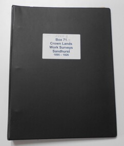
Photograph - CROWN LANDS WORK SURVEYS 1895 - 1926
... Hospital Bendigo Crown Lands Work Survey surveying land ...Black folder contains 14 buff coloured foolscap booklets in individual plastic pockets, listing crown lands work surveys in Bendigo. Pages are handwritten.hospital, bendigo, crown lands work survey, surveying, land -
 Bendigo Historical Society Inc.
Document - LANDS OFFICE: REGISTER OF CROWN LAND LOTS SOLD BY PUBLIC AUCTION, 1951 - 1987
Document: hard cover journal, black cover with buff spine and edges. 89 pages entered with details of sales by public auction of crown lands. LH page: lot, county, town or parish, allotment, section, area, survey fee paid, upset price per lot, sold for per lot. RH page: value of improvements if any, name of purchaser, address, purchase money paid, grant fees and assurance paid.Lands Officeland sales, lands office, crown land, bendigo, kyneton, castlemaine, sea lake, girgarre, inglewood, echuca -
 Bendigo Historical Society Inc.
Document - LANDS OFFICE: SALE OF CROWN LANDS
Hard cover journal, green cover with buff spine and edges. Sticker on the front: Sale register 1934-1954. On the spine in red the number 16 and in black Land Sales 10-01-1934 to 31-12-1954. Pages entered with details of sales by public auction of crown lands. LH page: lot, county, town or parish, allotment, section, area, survey fee paid, upset price per lot, sold for per lot. RH page: value of improvements if any, name of purchaser, address, purchase money paid, grant fees and assurance paid.land sales, victoria, crown land sales, bendigo, central and northern victoria -
 Bendigo Historical Society Inc.
Document - LANDS OFFICE: CERTIFIED PLAN REGISTER
Document: hard cover journal. Buff cover with embossed edges. Spine has red insert with 'Certified Plan Register' printed in gold. 250 pages, with index in front of register. LH page: number, date of receipt, name, parish, tracing book, plan, decision of Board of land and works, gazette page, name of surveyors, date of survey, sent to, date. RH page: précis of minute. Dated 1878 - 1893, includes areas in central and northern Victoria.plan register, lands office, bendigo, plans, surveyed, victoria, northern victoria -
 Canterbury History Group
Article, Don Gibb, The Elgar's Special Survey
Copy of a talk given by Don Gibb to the Canterbury History Group in June 2015 on the Elgar Survey which will be the basis of the second chapter of his forthcoming book on the social history of Canterbury. Includes maps and a list of the first Boroondara ratepayers.canterbury, mcwilliam. gwen, land subdivision, port phillip district, maps, gibb> don -
 Bendigo Historical Society Inc.
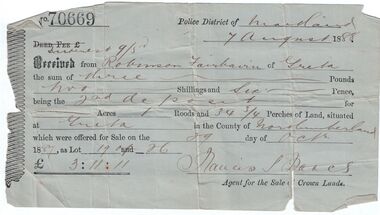
Administrative record - Land purchase records - Maitland NSW, 1888-1889
Northumberland County was one of the original Nineteen Counties in New South Wales and is now one of the 141 Cadastral divisions of New South Wales. The Greta area was first colonized by Europeans around Anvil Creek in the 1830s. When the town was surveyed in 1842 it was given the name Greta, possibly after a small river in Cumberland, England. Coal mining was established in the area in 1862 with the development of a railway station.Robinson Fairbairn Collection: Two documents. 1. Receipt for payment from Robinson Fairbairn of Greta for purchase of land at Greta, NSW. Dated 7th August 1888. Receipt for £3/11/11 includes Interest noted at top. 2. Invoice to Mr. Robinson Fairburn for land purchase in account with Sparke and Clift, Auctioneers, West Maitland. mining, robinson fairbairn collection, maitland, northumberland, greta nsw, sparke and clift, coal -
 Ringwood and District Historical Society
Document - Department of Lands and Survey, Wire Netting Branch, Melbourne, Victoria, Application for Vermin-Proof Fence Certificate - L.J. Mills vs John Collins, Grandview Grove, Ringwood, Victoria - 1939
Photocopied file of corresponence and documentation relating to a claim by L.J. Mills, Nurseryman, that adjoining property owner, J. Collins, Farmer, assists with replacement of a vermin proof wire netting dividing fence destroyed by 1939 bushfire. File includes 1939 and 1940 detailed property inspection reports by Vermin and Noxious Weeds Branch, Lands Department, Lilydale, describing land use in the area and signs of vermin activity. Application approved 18th April, 1940. Appeal lodged by Mr Collins disallowed in May, 1940. File closed June, 1940 with Departmental suggesion that Mr Mills consider further legal action through a Solicitor as fence had still not been wire-netted. TRANSCRIPTS: Vermin & Noxious Weeds Inspection Reports "19/9/1939 (To) Superintendent (Department of Lands and Survey, Melbourne) Re L.J. Mills application for Vermin Proof Fence. I called on Mr Mills yesterday 18th instant in connection with this matter. Mr Mills has a flower farm and claims that rabbits and hares are damaging his flowers. He showed me a bed of carnations which he stated were being damaged by rabbits. There was evidence of some leaves being nipped off, but I am unable to say whether this is due to rabbits or grubs. Very little if any real damage is being done. The property is netted on the east and south boundary and on half the north and west boundary. The surrounding country is undlating and fairly steep in places. The land to the east across Grandview Avenue (sic) is all planted out in old established orchards and well cultivated. Cleared grass land adjoins the south boundary and bush land adjoins the north and west boundaries. I walked over a large area surrounding Mr Mills land and never saw any rabbits or hares or any indications of rabbits. This locality is not rabbit infested and very little wire netting is being used. I do not consider that a vermin proof fence is necessary between these allotments. - Jas H Allison (Inspector, Vermin and Noxious Weeds Branch, Lands Department, Lilydale)." Follow up report following renewal of application for Certificate by Mr Mills, citing rabbits causing considerable damage to his flowers. He laid poison and obtained 9 carcases and stated that there is evidence of rabbit infestation from the adjoing land. "19/3/1940 (To) Mr Hannah (Superintendant, Department of Lands and Survey, Melbourne) Re L.J. Mills, Grandview Grove Ringwood, Lot 4 Grandview Estate Pt CG20 Ph of Warrandyte. I interviewed Mr Mills at his home on 15th inst. He showed me carcases of rabbits which he stated had been poisoned on his land. In places young plants had been nipped off apparently by rabbits. I made an inspection of adjoining properties and found one live burrow close to Mr Mills northern boundary. There were scratches and other evidence of rabbits on land north and west of Mr Mills property. In view of the present evidence of rabbits I consider that a vermin proof fence is now necessary to protect the flowers grown by Mr Mills. His land is netted on whole of east and south boundary and half way on west and north boundary. The adjoining land on west and north boundaries is owned by Mrs Linda Collins and John Collins resp of Brysons Road East Ringwood. - Jas H Allison (Inspector, Vermin and Noxious Weeds Branch, Lands Department, Lilydale)." -
 Bendigo Historical Society Inc.
Document - LANDS OFFICE, CROWN LANDS SURVEYED AND SOLD SANDHURST DISTRICT, 1854 (?) onwards
... PLACE Land sales bendigo Lands Office land surveyed land ...Document: buff colour hard cover journal. Contains details of crown lands surveyed and sold. On LH page, town, suburban or country lands. RH page: auction, selection, price per acre, price and purchaser. Indexed by parish in front page. Two front pages cut out. On spine ' Index book' ' Lands and Survey' '06' 'E' ' Country' and 'Sales'Lands Officeplace, land sales, bendigo, lands office, land surveyed, land sold, sandhurst -
 Bendigo Military Museum
Administrative record - Manual of Land Warfare - RASvy (Draft) by Maj C Watson 1984, Major C Watson, Canberra, 31 Jan 1984
This is a DRAFT document laying out the lines of command and control and duties of RASvy in Land Warfare. The document was prepared by Major C Watson in 31 Jan 1984. The document is missing its Title page. The Title was transcribed from an accompanying document " Technical Reports and papers held by Charlie Watson."26 x paper A4 sized pages of typed text, diagrams and tables held together with an ARNOS fastener. The document is missing its Title page. The Title was transcribed from an accompanying document " Technical Reports and papers held by Charlie Watson."royal australian survey corps, rasvy, fortuna, army survey regiment, army svy regt, asr -
 Warrnambool and District Historical Society Inc.
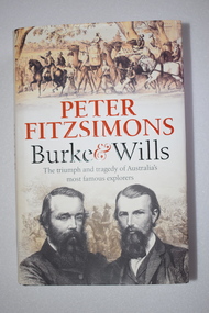
Book, McPherson’s Printing Group, Burke & Wills, 2017
This book gives a comprehensive and scholarly account of the ill-fated Burke and Wills expedition in Australia in 1860-1961. It is written by Peter Fitzsimons. The narrative includes the parts played in the expedition by two men who also had important connections to Warrnambool. One of these was Henry Foster who was Superintendent of Police in Swan Hill in the 1860s. In the early 1840s Henry Foster and Thomas Strong took up a run of 16.000 acres (St. Mary’s, Wangoom)). Their land was bounded on the south by the Southern Ocean, on the east by the Hopkins River, on the north by a fence from the Hopkins to the Merri Rivers and on the west by the Merri River and included the later surveyed site of the Warrnambool township. After Warrnambool was established Foster was able to retain 450 acres of the original run near Wangoom on the Hopkins River. He was active in Warrnambool’s early history, was a Justice of the Peace for the Belfast (Port Fairy) district in the late 1840s and his portrait is on the Warrnambool Pioneer Honour Board. The other local Warrnambool personality mentioned in the Burke and Wills book is Richard Bennett, in the 1860s, the manager of several large farming properties in N.S.W., including Canally Station on the Murrumbidgee where he came into contact with the expedition leaders. In the Warrnabool district Bennett was well-known from the 1870s to his death in 1904 as the proprietor of wool-scouring establishments on the Shaw River and at Dennington and as a public campaigner for local coal exploration, for artesian bore drilling and for numerous other projects, including the development of the local wool industry. His portrait is also on the Warrnambool Pioneer Honour Board. This book is retained as an account of an important event in Australia’s history and because it has several references to two men (Henry Foster and Richard Bennett) who also played a part in Warrnambool’s history. This is a hard cover book of 700 pages. The cover is black with gold printing on the spine and the dust cover has a cream background with light brown and black printing, black and white photographs and sepia-coloured sketches. The contents include a List of Maps, Dramatis Personae, Background and Acknowledgements, Prologue, 18 Chapters, Epilogue, Endnotes, Bibliography and Index. The pages contain maps, sketches and black and white and colour photographs. australian exploration, burke and wills expedition, richard bennett, warrnambool, henry foster, st. mary’s wangoom, history of warrnambool -
Canterbury History Group
Document - Thematic Environmental History, Built Heritage, 1/05/2012
Thematic Environmental Heritage. Final document produced, after community consultation, for the City of Boroondara by Built Heritage242 pages city of boroondara, back yards, canterbury, churches, cottages, dairies, danks family, elgar survey, exploration, frognall, goldings boot factory, maling road, malone's hotel, maps, masonic lodges, national parks, native plants, outer circle railway line, police stations, post offices, railways, rochester road, schools, shrublands, soldiers memorial hall, sport, telephone exchanges, theatres, transport, wildlife, canterbury road, land subdivisions, parks and reserves -
 Federation University Historical Collection
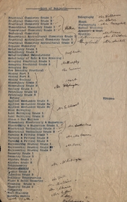
Document, List of Subjects
... Mechanics Mr Hart Mine Surveying Land Surveying Steam and Gas ...School of Mines Ballarat is predecessor of Federation University Foolscap sized list of Subjects from Ballarat School of Mines with handwritten names.8S3S in large writng on the back school of mines ballarat, practical chemistry, mr. walker, theoretical chemistry, theoretical agricultural chemistry, practical agricultural chemistry, technical chemistry, metallurgy, alfred mica smith, metallurgical calculations, metallurgy of gold and ore dressing, assaying practical, assaying dry, mr. murphy, ore dressing practical, mining, mining geology, mineralogy, geology, petrology, botany, applied mechanics, mr hart, mine surveying, land surveying, steam and gas engines, mr gilchrist, elementry electricity & magnetism, electrical technology, mr sutherland, turning and fitting, mr connon, engineering drawing, mr kerr, geometry, algebra, trigonometry, physics, conics, calculus, mr whitington, building construction, plane and solid geometry, plumbing grade, mr hall, mr mullins, carpentry, wool classing, materia medica, mr gutheil, technical arithmatic, mr hutchison, telegraphy, mr williams, sloyd, mr slater, photography, mr campbell, manual training, cyanide, mr deane, mr brittain, mr martell, english, astronomy, list of subjects -
 Mont De Lancey
Book, Australian Primary Producers Union Wandin Branch Minute Book
This blank book was used by The Australian Primary Producers Union Wandin Branch. Minutes of the first meeting were taken Nov 20th 1947 in the Seville Hall and the last minutes were on 23.11.1954.A large green paper patterned covered Minute Book with orange tape on the spine. This blank book was used by The Australian Primary Producers Union Wandin Branch. Minutes of the first meeting were taken Nov 20th 1947 in the Seville Hall and the last minutes were on 23.11.1954. The book is filled with Minutes of meetings and has two paper insertions - a paper photopcopy of an Invoice Wandin Yallock April 30th1909. Mr Aitken for The Evelyn Preserving Co. Limited Manufacturers of Pure Jams and Jellies. Terms Cash. On the same paper The Colonial Bank of Australasia Limited stating a Sale and acknowledgement receipt of a letter and the enclosure of a remittance, signed by the manager. The second insertion is dated Sept 1950 - a Survey of cost of Production Berry Fruit Wandin Silvan Area. Youngberries. Based on Land at 100 pounds per acre and average 2 ton crop. Full details are listed.non-fictionThis blank book was used by The Australian Primary Producers Union Wandin Branch. Minutes of the first meeting were taken Nov 20th 1947 in the Seville Hall and the last minutes were on 23.11.1954. meetings, reports, proceedings, minutes of meetings -
 City of Moorabbin Historical Society (Operating the Box Cottage Museum)
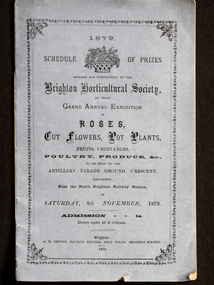
Booklet - Schedule Booklet, horticultural prizes, "1879 Schedule of Prizes Brighton Horticultural Society", 1879
This booklet from 1879 was given to the Moorabbin Historical Society when the Robert Keys Leader Cup Trophy, 1882-1883 was re-discovered at 'Box Cottage' Museum in 2009. The Leader Cup Trophy, MAV 00001, is also itemised in this booklet (p9) The Leader Newspaper offered the 'Silver Cup, value Five Guineas for the best fruit garden in the Brighton District. The Proprietors of the English, Scottish and Australian Chartered Bank offered an second prize of three Guineas Commencing in 1856, the Brighton Horticultural Society only disbanded in 2009, and most of their archival holdings were given to the Brighton Historical Society. This booklet gives a good idea of the large varieties of plants, poultry and the skills of the pioneer settlers of the Brighton District.This Booklet describes the Schedule of Prizes for the 1879 Grand Annual Exhibition of the Brighton Horticultural Society in Brighton Victoria. The Booklet was donated to the Moorabbin Historical Society in 2009 upon the disbanding of the Brighton Horticultural Society..at that time. The Moorabbin Historical Society possesses the 1882 'Leader Cup Trophy' (cat 00001) presented to Robert Keys for the best Fruit Garden. This booklet is kept in the same cabinet as the Robert Key's Silver Trophy. After Henry Dendy's Special Survey in 1841 allotments of land were sold or rented to pioneer settlers who developed market gardens , fruit gardens and poultry farms in the Brighton area. Their produce was sold at the St Kilda and Melbourne Markets for the growing population of MelbourneBooklet with mauve paper cover and 16 pages listing the Schedule of prizes for the 1879 annual exhibition of the Brighton Horticultural Society to be held in Brighton, Victoria."1879/ SCHEDULE OF PRIZES/OFFERED FOR COMPETITION BY THE/ BRIGHTON HORTICULTURAL SOCIETY,/ AT THEIR/ GRAND ANNUAL EXHIBITION/ OF / ROSES,/ CUT FLOWERS, POT PLANTS,/ FRUITS, VEGETABLES,/ POULTRY, PRODUCE, &c.,/TO BE HELD IN THE/ ARTILLERY PARADE GROUND, CRESCENT, / BRIGHTON,/ Near the North Brighton Railway Station, / ON / SATURDAY, 8th NOVEMBER, 1879./ ADMISSION 1s. / Doors open at 2 o'clock. / Brighton: / G. H. ORFORD, MACHINE PRINTER, NEXT NORTH BRIGHTON STATION. / 1879 ;melbourne, keys robert, trophy, leader newspaper, leader cup, brighton, silver, moorabbin, bentleigh, markets, dendy henry, st kilda, bent thomas, market gardens, brighton horticultural society, fruit gardens, banks chartered -
 Bendigo Military Museum
Souvenir - Souvenir Booklet of Land Headquarters Cartographic Company, Australian Survey Corps "Fortuna" Bendigo 1942-45, Land Headquarters Cartographic Company, Australian Survey Corps, 1945
A Souvenir Booklet recording the Section photos and a Nominal roll of those who served 1942-45 at the Land Headquarters Cartographic Company, Australian Survey Corps located at "Fortuna Villa" Bendigo was produced at the end of WWII. Each member of the unit was presented with a copy of the booklet. The booklet besides being a great memory for those who served is a very valuable resource as it names the individuals in the photographs and very importantly records a Nominal Roll of unit members and their Military details. This booklet is one of those original booklets. The booklet has been reprinted on a number of occasions with different coloured covers. The first and original booklet had a red cover. Editions with brown, dark blue and black exist. The black covered edition was the last reprint. This booklet was donated by Carol Hargrave of Grenfell, NSW after discovering it in an old trunk that she purchased. A black covered edition was donated by a local Bendigo Antique Dealer in September 2024.A4 sized red cloth covered hard covered book mainly containing sub-unit photographs of section members and includes their names. 23 x double sided pages of photographs and 2 double sided pages of a Nominal Roll of those who served at Fortuna 1942 - 45. Each of the 50 pages were scanned at 600 dpi in JPEG (.jpg) format and stored on the attached 16GB USB Memory Stick. The images have been converted into MPEG-4 (.mp4) video format, 9Mb in size that runs for 4 Minutes and is also stored on the memory stick.royal australian survey corps, rasvy, fortuna, army survey regiment, army svy regt, asr -
![Painting: Park Street [Adeney Avenue] Kew](/media/collectors/550653872162f11fb04854aa/items/5826877cd0cdd11284ad5413/item-media/614ac683a53a0756fd5e49da/item-fit-380x285.jpg) Kew Historical Society Inc
Kew Historical Society IncPainting, Park Street [Adeney Avenue] Kew, c. 1896
‘Adeney Avenue’ was the title given to this painting following its donation to the Kew Historical Society, yet the work’s origins predate the naming of Adeney Avenue in 1907 [originally gazetted as ‘Park Street’ (1865) and ‘Park Street South’ (1875).] Park Street ran between High Street and Parkhill Road beside what was later to become ‘Victoria Park’. This area was described in 1851 as “…a dense forest of gums and wattles which were to be largely cleared by 1888 after the naming of a recreation reserve”. The Reserve was still bisected by an unnamed creek in 1896, when the area was surveyed by the MMBW. The panoramic vista selected by the artist would appear to include ‘Eborensis’ (c.1895) on the corner of Parkhill Road and what was then Park Street, with views across cleared land towards the distant ranges. In the 19th century, north Kew was largely undeveloped farms stretching down to the Yarra. Oil on canvas by an unidentified artist of a panoramic view depicting what is now known as East Kew with mountains on the horizon. In the foreground is a two storey brick residence - Eborensis - located on the northeast corner of Parkhill Road and what is now Adeney Avenue. The view of the landscape and its rolling hills resulted from farming practices adopted following colonisation and settlement. Trees in the foreground and in the distance include remnant Eucalypts and introduced exotics.Label on rear of frame states "House on corner of Adeney Ave & Parkhill. [Regd. 254"]. Otherwise unsigned and undatedadeney avenue (kew), eborensis, park street (kew) -
 Kew Historical Society Inc
Work on paper - Sepia Wash & Ink, G B Richardson, Creek and Old Watering Stage, on the Yarra, East Collingwood, 1854, 1854
Blind Creek was located between the Abbotsford Convent and what is now the Collins Bridge in Studley Park. In an 1858 map of East Collingwood by Clement Hodgkinson, in the State Library of Victoria, one can see how the creek was originally a significant landmark in Collingwood; remaining vacant land until a barrel drain enclosed it. The area was later filled in, surveyed and developed. The position where Blind Creek entered the Yarra was in the immediate vicinity of Hodgson’s Punt, which had linked Kew to the other side of the Yarra from 1839. The Punt was purchased by the Colonial Government in 1852 and was in use until the opening of the Studley Park Road (Johnston Street) Bridge in 1858 made its continued use redundantThe point of view selected by the artist for the watercolour is from the banks of Blind Creek in East Collingwood, looking across the Yarra to the Kew side of the river.Inscribed verso 'Creek and Old Watering stage, on the Yarra East Collingwood 1854 / Trees, stage, &c have long since disappeared / [Artist Signature] / FT 110 / Creek itself now being filled in 1903.gb richardson, blind creek - abbotsford, yarra river - abbotsford (vic) - kew (vic), colonial artists, australian art - 19th century, george bouchier richardson -
Bendigo Historical Society Inc.
Map - PARISH OF SANDHURST 1961, 1961
BHS CollectionAt Bendigo Parish of Sandhurst. Sheet F.Dept of Lands and Surveybendigo, land sales, parish map -
Bendigo Historical Society Inc.
Map - PARISH OF SANDHURST 1961, 1961
BHS CollectionAt Bendigo Parish of Sandhurst. Sheet 13Dept of Lands and Surveybendigo, land sales, parish map