Showing 11589 items matching " map"
-
 Ringwood and District Historical Society
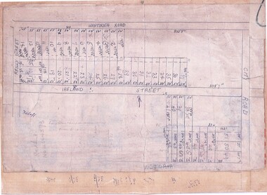
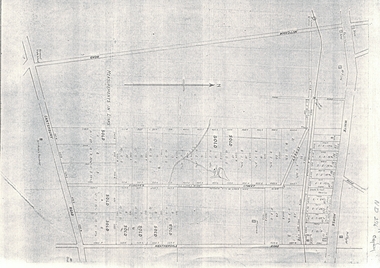
Document, Subdivision Map (Undated) - Ringwood, Victoria
Hand-drawn copy of subdivision plan showing numbered residential allotments with property dimensions.Map includes Wantirna Road, Ireland Street, City Road and Victoria Street (later Regina Street), Ringwood, Victoria. -
 Whitehorse Historical Society Inc.
Map, Aerial photographs Nunawading, 1976
Department of Crown Lands and Survey, Melbourne, 1976 Project.Department of Crown Lands and Survey, Melbourne, 1976 Project. Runs 29 - 33 City of Nunawading. Frames numbered from South to North boundaries, each strip numbered from West to East. No index map. Sheets 30/8 and 30/9 missing.non-fictionDepartment of Crown Lands and Survey, Melbourne, 1976 Project. victoria. department of crown lands and survey, aerial photographs, nunawading, mitcham, blackburn, blackburn north, blackburn south, forest hill, vermont, vermont south, burwood east, box hill, ringwood -
Whitehorse Historical Society Inc.
Map, Subdivision of Allotment 122a, 1972
Subdivision of land along Livermore Close and Moore Road, Vermont South.Subdivision of land along Livermore Close and Moore Road, Vermont South. Original survey Rob Poole 1899. Stamp indicates 'Land on this plan is in proclaimed survey No 21. Survey Coordination Act 1940. As from 9 Aug 1972. Two maps in different scales.Subdivision of land along Livermore Close and Moore Road, Vermont South. land subdivision, livermore close, vermont south, moore road, vermont south, dandenong creek -
4th/19th Prince of Wales's Light Horse Regiment Unit History Room
Maps, Major & Mrs Holt's Battle Map of Gallipoli, 2000
Brochure containing battle field maps of Gallipoli campaign. Designed as a guide for visitors97809585229662maps, gallipoli. holt -
4th/19th Prince of Wales's Light Horse Regiment Unit History Room
Booklet (4 copies), Hints on Map Reading Instruction 1943, Aug 1943
Soft covered booklet issued to help junior instructors in the teaching of map readingmap reading -
 Federation University Historical Collection
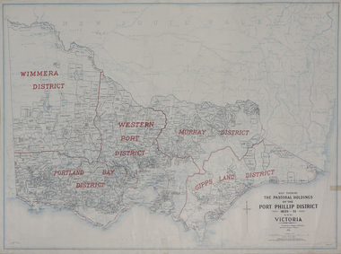
Plan, Map Showing the Pastoral Holdings of the Port Phillip District 1835-1851 Now Victoria, 1932, 1932
Another name for Pastoral Holdings is squatting runs. Information on Alfred Stephen Kenyon of the Historical Society of Victoria can be found at http://adb.anu.edu.au/biography/kenyon-alfred-stephen-6936/text12035 Map of Victoria showing the boundaries of the Port Phillip District (Victoria) pastoral boundaries. pastoral holdings, squatters, squatting, victoria, land, crown lands, a.s. kenyon, alfred stephen kenyon -
 RMIT Design Archives
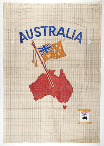
Mixed media - Drawings, Design for clothing label featuring map of Australia
Cash's first began manufacturing name tags, woven badges and woven labels in Australia in 1913, and since then countless Cash's labels have been sewn onto school and club jumpers. Point paper design featuring map and flag. Corresponding clothing label attachedtextile design, rmit design archives -
National Vietnam Veterans Museum (NVVM)
Photograph, Sketch of Battle Map, Ngok Tavak, Mary 1968
Captain John E D White, Australian Army Training Team in Vietnam (AATTV) took over command of 11 Mobile Strike Force (Mike Force) Company in Da Nang, Vietnam, in February 1968. He was 26 years old. The 2 NVA Division was moving from Laos into South Vietnam and his mission was to establish contact with the division and trace its movements south. In mid-March the company was air lifted to the Special Forces camp of Kham Duc, near the Laotian border. They used an old French Foreign Legion fort as a temporary base from which patrols could be sent out. White called it Ngok Tavak after a nearby mountain. Initially, patrols failed to find the enemy, but in late April a patrol clashed with the enemy. At the same time, White received intelligence that the NVA division was closing in. At night they could hear explosions in the distance heading toward them. White decided their best chance was to leave the fort and take to the jungle to adopt guerrilla tactics. However, in the meantime a platoon of United States Marine Corps artillery arrived bringing with them two howitzers and a stockpile of ammunition. To abandon the fort was to abandon the guns. White contacted Da Nang, explaining the predicament, and was ordered to remain where he was. A Civilian Irregular Defense Group (CIDG) platoon was sent to reinforce his numbers. This was a para military force comprised mainly of indigenous highlanders, trained by United States Special Forces. They also brought with them two mortars and their crews. At 3.15am on 10 May 1968 some members of the CIDG chose to assist the NVA to attack the fort instead of supporting Mike Force, and close hand to hand fighting followed, along with grenade attacks and heavy machine gun fire. Air support offered a brief respite from the NVA attack, and some NVA forces were pushed back outside the perimeter by counter attacks, but at 9am White contacted Da Nang to advise that his position was untenable. A second attack was imminent and they could not withstand it, so they would have to withdraw. The wounded were evacuated by helicopter (under orders from Major Mai, the NVA had not attacked the previous medical helicopters that collected the wounded under the cover of air strikes) and at 1pm the rest of the force evacuated east, into the jungle. The NVA did not notice their withdrawal, and continued mortar attacks on the fort for another ninety minutes. Seven kilometres from the fort White called for a helicopter withdrawal of his forces. The force was successfully lifted to Kham Duc and then Da Nang. (Credit AWM)Annotated hand-drawn map of the fort at Ngok Tavak, 10 May 1968.battle of ngok tavak, john white, battle map -
 Ballarat Heritage Services
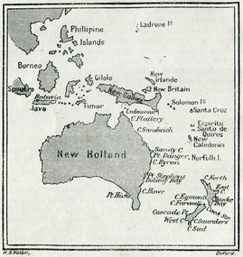
Map, New Holland and New South Wales as Known after Cook's Voyages
Copy of a map from 'A Short HIstory of Australia' by Ernest Scott.map, explorers, exploration, new holland, norfolk island, point hicks, timor -
 Stawell Historical Society Inc
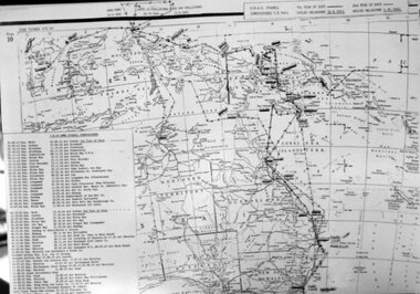
Photograph, H.M.A.S. Stawell Corvett Class -- Tour of Duty Map
Corvette H.M.A.S. STAWELL Tour of Duty Mapstawell ww2 -
4th/19th Prince of Wales's Light Horse Regiment Unit History Room
Booklet, Capt W Stanley Lewis MSc, FRGS, Military Map Reading for the New Army, Feb 1941
Soft covered booklet covering various details of military maps and how to read them. Price Two shillings and six pencemanual, map reading -
Whitehorse Historical Society Inc.
Document, Map of Orchards, 1922
1922 Map of orchards in the City of Nunawading, coloured green. This is a magnified localised view of ND66orchardists, orchards, blackburn, mitcham, tunstall, vermont, east burwood, tally ho -
 Ringwood and District Historical Society
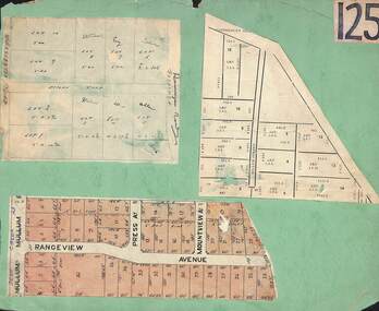
Card, Collage of Residential Subdivision Map Clippings - Ringwood, Victoria - (Undated)
Three maps mounted on green cardboard - Hand-drawn map of residential allotments off Warrandyte Road in Milne Road and Berringa Road Park Orchards. Map with acres roods and perches measurements of allotments in Canterbury Road and Miller Street Heathmont. Clipping from a land sale brochure with street names not existing together in the area - Rangeview Avenue, Press Avenue and Mountview Avenue. -
 Warrnambool and District Historical Society Inc.
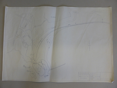
Map, Soil conservation authority:plan of high water marks at Lady Bay Warrnambool, 1984
This map documents the changing state of Lady Bay from around 1870 until 1976. It depicts the changing high water mark over that period and the main outlet of the Merri River in 1872 and 1976.This map provides a useful and significant insight into the ever changing face of Lady Bay from the 1870’s through to 1980’s. Cream paper map drawn with black ink showing Lady Bay and South Warrnambool section of Warrnambool. In lower RH corner Soil conservation AuthorityPlan of High water marks at Lady Bay Warrnambool. Drawn P.D. 19.1/84. Scale 1:3600. Written on back in black pencil: Lady Bay Historical HWM lady bay map, merri river 1872- 1976, merri river 1872- 1976, history of warrnambool -
 Lara RSL Sub Branch
Booklet, Map Reading Aide-Memoire 1973, 1973
Used by the Australian Army personnel to learn Map ReadingUsed by the Australian Army personnel to learn map readingA small rectangular booklet with cover and 26 pagesSee images of front cover and rear coveraustralian army, army, australia, map reading, booklet -
 Department of Energy, Environment and Climate Action
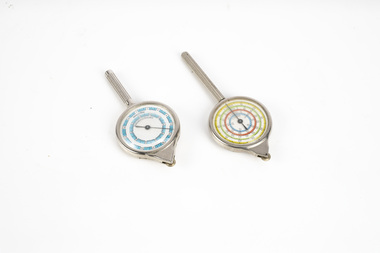
map measuring wheels
The map wheel is a simple, fast and accurate way to measure distances on maps, whether in straight lines or along curves. Hold the device from the tip and trace with the small wheel at the bottom along the line to be measured Measures distances in miles, kilometres or nautical miles depending on the scale on the side.Two metal map measuring wheel sMap scales on each side of wheelforests commission victoria (fcv), surveying, mapping -
 Melbourne Tram Museum
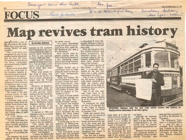
Newspaper, The Leader, "Map revives tram history", 31/03/1993 12:00:00 AM
Newspaper cuttings from The Leader, 31/3/1993, titled "Map revives tram history", about the launch of a printed map or poster giving the history of Melbourne's trams. See Reg Item 506 for the actual item. Article by Shane Jenkins provides snippets of history from the map or poster. Has a photo of the author, Stephen Watson standing alongside W6 964 with Bank of Melbourne adverts.Along the top edge, notes for Keith about the cutting, from Jan.trams, tramways, maps, publications, posters, tram 964 -
 Bendigo Military Museum
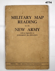
Booklet, CAPT W STANLEY LEWIS et al, Military Map Reading for the New Army, 1941
Military Map Reading for the New ArmyCardboard Covered booklet. This has 64 pages with illustrations. It is bound with 2 staples.Military Map Reading for the New Armymap reading, judging distance -
4th/19th Prince of Wales's Light Horse Regiment Unit History Room
Booklet, Map Reading Aide-Memoire 1973, 1973
Soft covered booklet aimed at assisting with most map reading and navigation problems. 2 copiesDSN 7610-66-058-5570map reading -
4th/19th Prince of Wales's Light Horse Regiment Unit History Room
Pamphlet (2 copies), Map Marking. Military Symbols, abt 1960's
A soft covered pamphlet showing the military map symbols agreed for use in the forces of SEATO, with explanationsmap symbols -
 Federation University Historical Collection
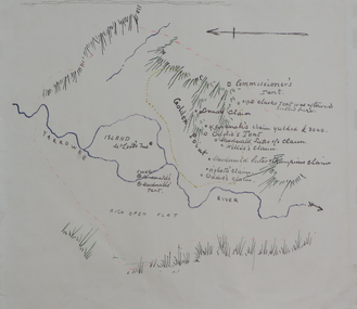
Plan, Dunn's Map of Early Gold Diggers at Golden Point, Ballarat, not dated
Hand drawn map in colour showing Yarrowee River and claims including James Oddie and Highett.dunn, dunn's map, comissioner's tent, oddie's claim, highett's claim, macdonald, suter & co claim, james oddie, golden point, gold discovery -
 Federation University Historical Collection
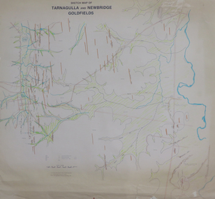
Plan, Sketch Map of Tarnagulla and Newbridge Goldfields, 1979, 1979
Pmap on paper with hand colouringtarnagulla, newbridge, map -
 Melbourne Tram Museum
Pamphlet, Public Transport Victoria (PTV), "Melbourne Official Visitor Map", 2012 to 2019
Set of 6 pamphlets - folded to DL size - full colour - each titled "Melbourne Official Visitor Map" giving location of various Melbourne attractions, transport information, ticketing, Myki, and visitor information. Has two maps - Melbourne and the inner suburbs and the CBD + Southbank area. .1 - 14 - fold - published 2012 - 13 - has standard tram and rail maps as well. .2 - 14 fold - published 2013 - 14, also has a map of Melbourne laneways. .3 - 12 fold - published 2016 - has D 3523 on front cover outside Flinders St Station. .4 - 12 fold - published 2015 - map of City Centre and Inner Melbourne, .5 - 12 fold - published 2017 - as above. .6 - 12 fold - published 2019 - as abovetrams, tramways, melbourne, ptv, maps, tramways, railways, tram 3523 -
 Warrnambool and District Historical Society Inc.
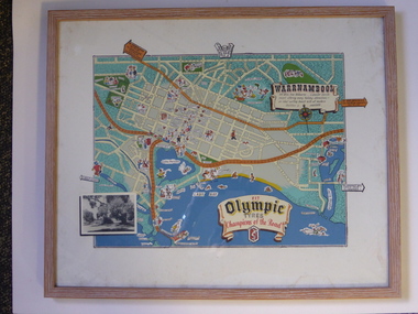
Advertising, Tourist Map of Warrnambool (framed x 2), 1950s
These framed tourist maps came from the Lane Foundation so it is presumed that they were from the office of Lane’s Travel Service which operated from 205 Raglan Parade Warrnambool with the known dates, the 1950s and 1960s. The proprietor, Alan Lane, was a successful Warrnambool businessman who operated a Warrnambool and district bus service as well as his travel business. He was heavily involved in local community affairs being a Warrnambool Councillor for 18 years from 1952 to 1970 and President of the Warrnambool Chamber of Commerce for six years. He was a major donor to the Warrnambool Performing Arts Centre, the Warrnambool Art Gallery and the St. John of God Hospital and left the bulk of his estate to the Alan Lane Foundation which has contributed millions of dollars to local organizations and programs. Alan Lane died in 1995. These framed maps are of some interest as examples of the tourism maps used to promote the city and district in the 1950s and 60s. This is a tourist map of the Warrnambool C.B.D. and adjoining streets produced as an advertisement for Olympic Tyres. It is multi-coloured and has cartoon sketches of the main tourist attractions and pointers to attractions outside of the main city area. It includes an inset black and white photograph of the Warrnambool Botanic Gardens and an advertisement for Olympic Tyres. It is printed on a white background and is enclosed behind glass in a wooden frame of a light brown colour. It has a wire at the back for attachment to a wall. ‘Warrnambool – 163 miles from Melbourne – a popular tourist resort offering many holiday attractions – an ideal surfing beach with all modern facilities is avalable’ ‘Fit Olympic Tyres, Champions of the Road’ alan lane foundation, warrnambool tourism -
 Clunes Museum
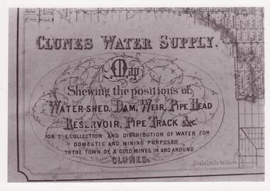
Document - MAP
CLUNES WATER SHED SUPPLY MAP SHEWING THE POSITION OF WATERSHED ECT. FOR THE COLLECTION AND DISTRIBUTION OF WATER FOR DOMESTIC AND MINING PURPOSES TO THE TOWN OF & GOLDMINES IN AND AROUND CLUNES.PHOTOCOPY SECTION OF PHOTOGRAPH AND PLAQUE AND MAP OF CLUNES WATER SUPPLY. SHOWING THE POSITION OF WATERSHED, DAM, WEIR PIPEHEAD RESERVOIR PIPE TRACK.SEE PHOTOGRAPH ON BACK OF HISTORY OF OBJECT.local history, photographs, water supply -
 Federation University Historical Collection
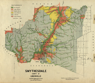
Map, Smythesdale, County of Grenville, 1888, 1889
The map maker, Ferdinand M. Krause, was a professor at the Ballarat School of Mines. This land was printed form the Crown Lands Department, Melbourne. Coloured map of the County of Grenville. The edge has been taped. The scale is 40 chains to 1 inch. The map is accompanied with a foolscap sheet printed by the Mines Department in 1898. It is a Report on the Parish of Smythesdale by F.M. Krause and includes information on the water reserve, worked quartz veins, Watson's Hill, Surface Hill and Sugarloaf Hill, Haddon, Trunk Lead and the Crucible Shaft. smythesdale, krause, f.m. krause, ferdinand krause, nitingbool, watson's hill, surface hill, sugarloaf hill, haddon -
 Federation University Historical Collection
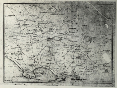
Photograph - Black and White, Map of Western Victoria
WGS 84 37" 47' S 142" 08' EPhotograph of a map showing the Grampians, Glenelg, Portland, Belfast (Port Fairy), Warrnambool, roads and land-holders.western victoria, victoria, belfast, port fairy, warrnambool, manifold -
 Whitehorse Historical Society Inc.
Document, Map of Vermont & Mitcham
Copy of map showing land in Mitcham and Vermont areasCopy of map showing land in Mitcham and Vermont areas bounded by Whitehorse , Mitcham, Canterbury and Heatherdale roads.Copy of map showing land in Mitcham and Vermont areasland subdivision, whitehorse road, mitcham, heatherdale road, canterbury road, vermont, mitcham road -
Whitehorse Historical Society Inc.
Document, Eastern suburbs map, n.d
Hand drawn map of eastern suburbs and railways of eastern suburbs showing heights above sea levelrailways, maps -
Warrnambool and District Historical Society Inc.
Document, signatures and a sketch map
This document comes from the Ardlie collection. It is presumed that it is part of the material that belonged to William Ardlie, a prominent lawyer in Warrnambool in the 19th and 20th centuries. It is not clear if the document is a copy or an original. It is an 1886 document in which the purchasers of Allotments 127,128 and 129 in Coulstock Street, Warrnambool requested a change to the original land situation. They wished to eliminate a laneway shown on the original purchase document owned by Adam Bell and transfer the lane land to the new purchasers. The signatures on the document include Isabella Helpman, R.D. Burall, Adam Bell, Anthony Derrick and another signature not able to be deciphered. The sheet includes a sketch showing the proposed change to the land division. This item is of minor interest as a document from the 19th century dealing with a land transfer proposal by some prominent Warrnambool residents at the timeThis is a sheet of paper with handwriting, signatures and a sketch map, all in black ink. The page is a little yellowed with age. adam bell, warrnambool, wiliam ardlie