Showing 1087 items matching " navigation"
-
 Lakes Entrance Historical Society
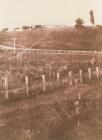
Photograph, Merrangbaur House Lakes Entrance Victoria, 1950c
formerly Merrangbaur House, showing the tree which for many years was a Lakes Entrance landmark and a navigation sign for boats entering the original entranceSepia toned photograph of Pine Hill, . Guest house is visible on brow of hill. Lakes Entrance Victoriaguesthouses, tourism, topography -
 Flagstaff Hill Maritime Museum and Village
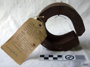
Steel Sample, ca. 1876
The sample of steel from which the S.S. Julia Percy’s boiler was made has been tested, according to the attached label. The test involved heating the steel to blood red temperature (or dark red colour) then dipping it into water and bending it when it was cold. A “very severe test for quality” was written on the ticket by T.H. Osborne. (Mr Thomas Hamilton Osborne was the secretary for the Western Steam Navigation Co, established in Warrnambool in 1886. The company’s office was on the corner of Timor and Liebig Streets in Warrnambool and its north-western wall is now part of the current Warrnambool Regional Art Gallery. ) Cold bending of steel in a press or through rollers is the typical method of curving steel for construction. The steel needs to be manufactured in such a way that it is strong enough yet still flexible enough not to crack when bent or rolled. The boiler on the Julia Percy could have been a Scotch Boiler, a design introduced in the 1870’s and still being used today. This design was more robust that previous boilers, generating higher working steam pressures. The design incorporate greater ability to roll iron plates, leading to greater strength, thicker plating and fewer riveted joints. They were originally made of iron then later incorporated steel sections until they were entirely constructed of steel. Many examples of this type of boiler can be found on wreck sites. Shipping was the cheapest and most practical means of carrying produce and goods during the period 1840-1890. Regular domestic steamer services commenced in the Warrnambool district in the late 1850’s and by 1870 the passenger trade was booming. Produce was loaded from the jetty into ‘lighters’ (small boats), which took it to the ships at anchorage in the bay. Passengers were taken to the ship’s side then climbed aboard up ladders or gangways. The coming of the railway in October 1889 meant the gradual decline and end of the steam shipping era. Originally the ship was known as the SS Julia Percy and was later renamed as the Leeuwin. She was an iron passenger-cargo steam ship built in Glasgow by Thomas Wingate for the Warrnambool Steam Packet Company, which commissioned the ship for the steamship trade in Victoria’s western district. She was first registered in Warrnambool, Victoria in 1876. At one point in time the Julia Percy would sail from Warrnambool to Melbourne every Friday and return from Melbourne to Warrnambool every Tuesday. The cost of a return ticket for a Saloon Fare was £1.0.0. She would sail “if practical and weather permitting”. The Julia Percy changed hands several times. Her next owner was the Western Steam Navigaiton Co of Melbourne (1887). It was the manager of this company, Mr. T.H. Osborne, who tagged ths steel sample above. Melbourne Steamship Co became the next owners (1890), followed by William Howard Smith and Sons (1901) for use in Queensland coastal trades, then she was bought by George Turnbull in 1903 and used for local mail contract in Western Australia. She was sold to the Melbourne Steamship Company Ltd. (1906) and re-named the Leeuwi but continued in her Western Australian coastal run. She was converted into a coal hulk in Melbourne in 1910 as a result of damaged caused when she was driven against the jetty at Dongara during a gale. The ship was eventually dismantled and scuttled in Bass Strait on 28 December 1934. The steel sample is significant for its association with the wreck of the Leeuwin (Julia Percy), which is on the Victorian Heritage Register. It is historically significant for being a rare artefact that has potential to interpret aspects of western Victoria’s 19th century steamship trade and Victorian cultural history, including the testing and manufacturing process associated with steam power. Leeuwin is listed on the Victorian heritage Register as being historically significant ‘as one of only four wrecks of steamships in Victorian waters associated with the western district of Victoria’s coastal steamship trade. Her registered number is VHR S413. A sample of the steel from which the boiler of the "SS Julia Percy" (later named Leeuwin) was made. The piece of steel is a ‘C’ shape with the ends almost meeting. A luggage ticket is tied onto the steel and has an inscription on it. The steel is rusty.Ticket with typed information “Steel of which the Boiler of the “Julia Percy” (Warrnambool Steam Navigation Co) was made. TEST: Made Blood hot or Dark Red then dipped into water and bent cold. A very severe test for quality T.H. Osborne. Below these words is the hand written inscription in black “FM 151 / 9.75” julia percy, leeuwin, steel, boiler, steam ship, metal testing, western steam navigation co., flagstaff hill, warrnambool, shipwrecked-coast, flagstaff-hill, flagstaff-hill-maritime-museum, maritime-museum, shipwreck-coast, flagstaff-hill-maritime-village, t.h. osborne -
 Flagstaff Hill Maritime Museum and Village
Document - Navigation Chart, Admiralty Office, Lady Bay and Warrnambool Harbour, 1893
This navigation cart of Lady Bay and Warrnambool Harbour was originally surveyed in 1870 but this version includes the update for magnetic variation in 1893. Since the printing of the chart several annotations have been added. These include an additional stamp dated 15-8-1910, a handwritten comment across the top of the page dated August 1910, and another handwritten comment regarding the ‘Proposed Extension of Dock’ dated 19-2-1925, plus connected drawings, notes and figures. The 1925 proposal on this chart may have been a reaction to the Royal Commission of 1923, when the damaged stonework on the seaward side of the Warrnambool Breakwater, caused by the action of the sea, was the subject of enquiry. A conference between the Public Works, Water Commission and the Harbour Trust concluded that it would less costly to make repairs to prevent further damage rather than replaced the damage portion of the wall. A contract was raised in late 1924 to deposit rubble on the damaged side of the breakwater to minimise the Southern Ocean’s destructive action and work had started by August 1925. The Breakwater construction had begun in 1874 and was completed in 1890. The Victorian Government had commissioned Sir John Coode, a British harbour engineer, to present a plan to complete the Warrnambool Breakwater but his original plan was too expensive. He prepared a revised plan for a shorter structure. The construction proved to be too short to protect adequately from the weather and didn't allow enough depth for larger vessels to come into port. The decreasing trade was further affected by siltation in the bay due to the breakwater, and the completion of the railway line. The situation of the harbour became a real problem by 1910 and required continuous dredging. In 1914 the Breakwater was extended but proved to be a failure because the work began to subside and by 1920 about two thirds of the harbour was silted up. Alterations made in the 1920's increased the silting problem and by the 1940's the harbour was no longer used. More alterations were made in the 1950's and 1960's. This chart is significant for its strong connection to the maritime history of Warrnambool Harbour and Lady Bay and the Warrnambool Breakwater. The Warrnambool Breakwater is registered as a place of significance on the Victorian Heritage Database (VHR H2024). The Warrnambool Breakwater is one of the most important late 19th century maritime engineering projects in Victoria and significant in the development of Victorian coastal shipping. It is also significant for its connection with British harbour engineer, Sir John Coode. The chart is a historical record of structures existing in 1893; the Warrnambool Jetties, Warrnambool Breakwater in Lady Bay, the leading lights (lighthouses), streets, roads, bridges and many buildings. It also shows the lay of the land and seabed. Navigation Chart: Lady Bay and Warrnambool Harbour, Australia - South Coast - Victoria. Surveyed by Nav. Lieut. H.J. Stanley, R.N., 1870. Updated for Magnetic Variation, 1893. The rectangular chart is printed on heavy cream paper. Stamps are shaped rectangular, oval and round. Around the Breakwater and Jetty area are handwritten notes, dotted and joined lines, numbers and signatures, and shading of red and green. The chart shows the surrounds of Warrnambool Harbour, Lady Bay, the Breakwater and Jetty, roads, bridges and the streets in Warrnambool. It has sounding details, and angles of line from the leading lights.Stamp, rectangular, including "AUG 1910" Stamp, double oval " - - - -CHART" Stamp, hand drawn, red circle, with "B" inside Hand written note "22-8-1910 - - - - - of surveying C. Ca - - - request of 15-8-10 [initials] " Notes and lines in red pen, including a grid of sounding numbers: "1300" "1050" "1200" "Possible Extension of Dock" "19-2-25" "Dock Dredged to 20 Ft" Notes and lines in blue pen "Extension of Dock to accommodate vessels drawing 20 Feet" and "Light not visible south of this line" Red dots (4) with yellow highlight at both leading lights, breakwater and jettyflagstaff hill, warrnambool, flagstaff hill maritime museum & village, maritime museum, maritime village, shipwreck coast, map, chart, navigation chart, plan, lady bay, warrnambool harbour, port of warrnambool, breakwater, jetty, pier, dock extension, proposed extension, vhr h2024, 1870, 1893, 1910, 1925, warrnambool town late 1800s, warrnambool streets late 1800s royal commission, 1923, public works, water commission, harbour trust, victorian harbours, sir jon coode -
 Lakes Entrance Historical Society
Postcard - The Entrance at Lakes Entrance, Murray Studios Gympy Qld, 1930 c
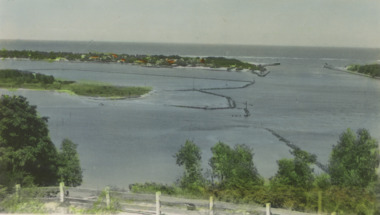
Also a second hand colourewd postcard of similar view showing navigation light on right side of photo 05366.1 6.5 x 10 cmColoured postcard showing view of houses at the entrance and New Works buildings and western end of Bullock Island and rock groynes. Post and rail fence on Jemmys Point Lakes Entrance VictoriaMurray views No 32 A picture view of the Entrance at Lakes Entrancewaterways, islands -
 Bendigo Military Museum
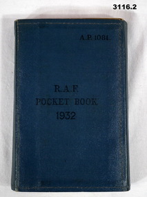
Book - BOOK, RAF, Air Ministry, RAF Pocket Book 1932, 1932
.1) Folding, wrap around pocket book, blue buckram. Title is embossed in black ink. Booklet contains large amount of information on RAF basic subjects if navigation, liaison signalling, ranks, aircraft markings or worlds air forces, camping, 142 pages. .2) Amendment List No's dated 1933.Centre: “RAF Pocket Book 1932” Top right: “AP 1081”books-military/reference, military history-air force, raf -
 4th/19th Prince of Wales's Light Horse Regiment Unit History Room
Map Set, Timor Leste, 1999
Operational maps for Australian Defence Force participation in InterfetSet of maps for Timor-Leste Op Interfet 1. Ermera District Navigation Map 1:25,000 2. Dare Area Special 1:25,000 3. Timor-Leste Parliamentary Elections 4. Dili Planning Map Overlay Timor-Leste 1:6,000 5. Timor-Leste Planning Mao -
Moorabbin Air Museum
Book - Aviation Ground School Training - Cadet System, The Nes Cadet System of Ground School Training
Text for ground school cadets on navigation, meteorology, radio beam flying & orientation , circa 1930sManual style booknon-fictionText for ground school cadets on navigation, meteorology, radio beam flying & orientation , circa 1930snavigation, meterorology, radio beam fl, orientation circa 1930s -
B-24 Liberator Memorial Restoration Australia Inc
Bubble sextant, Henry Hughes & Son, c.1930s
These instruments were used on aircraft to obtain the altitude of the sun or other celestial body to aid navigation. This particular one came from a former RAAF pilot.This bubble sextant, complete with original wooden storage case with leather strap, was manufactured c.1930s. Black and metallic, it has a mirror in the middle, various knobs on the sides and a cylindrical handle on each side.sextant, altitude, navigation, instrument -
 Port Fairy Historical Society Museum and Archives
Photograph
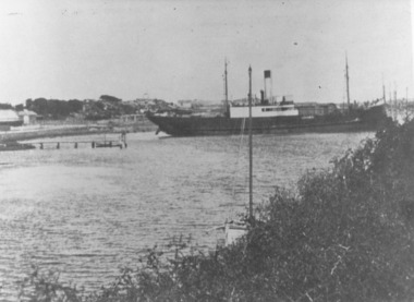
This shows the S.S.Wannon turning in the specially widened part of the river called the "turning basin" before slipping into her berth at the Belfast and Koroit Steam Navigation Company wharfBlack and white photograph of SS Wannon turning in the Moyne Rivership, boat, sea, moyne river, belfast and koroit steam navigation company, turning basin -
 Lakes Entrance Historical Society
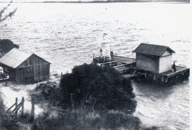
Photograph - Nungurner Jetty, 1938
Reprinted from Rev. Alfred Maher's photo album, Anglican Church Archives, Sale, VictoriaBlack and white photograph of Nyerimilang Jetty, Gippsland Lakes. It shows a short jetty with boat landing, navigation light and storage shed on jetty, boatshed on bank. Small motor car beside boat shed. Distant view across lake to eastern point of Flanagan Island, Fraser Island and Rigby Island. Lakes Entrance Victoriajetties, boats and boating, waterways, topography -
 Lakes Entrance Historical Society
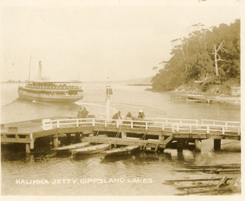
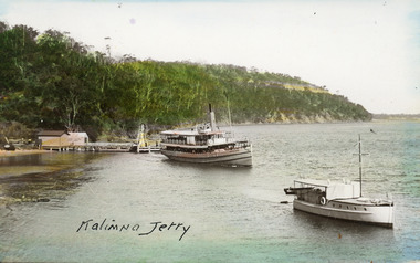
Postcard - Kalimna Jetty, 1920c
also Black and white copy 10 x 12|also Sepia toned copy 10 x 15Sepia toned small format postcard of the steamer Gippsland leaving Kalimna Jetty, Gippsland Lakes Victoria, also showing boat ramps beside jetty, three rowing boats moored at lower landing, persons pushing trolly along jetty, Navigation light on jetty, rustic jetty and small boat in background. Lakes Entrance VictoriaKalimna Jetty Gippsland Lakesjetties, waterways, ships and shipping -
 Glenelg Shire Council Cultural Collection
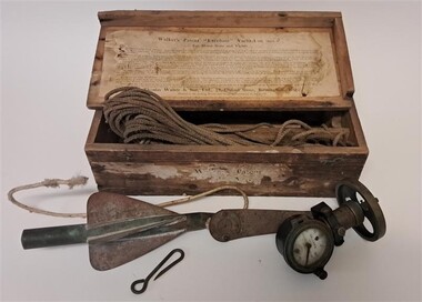
Functional object - Walker's 'Excelsior' Yacht Log Mark II, Thomas Walker, c. 1900
From Scarborough Maritime Heritage Centre: A Yacht Log was a nautical instrument for measuring a vessel's speed and distance travelled. When navigating a ship it is essential to be able to estimate the boat's speed and distance travelled to determine its position at sea. In times past the only way to measure a ship's speed was to throw a wood log into the water and observe how fast it moved away from the ship. In the 16th century, the log was fastened to a rope knotted at set intervals. The log was thrown over the stern (back) of the vessel and a crew member counted the number of knots that were paid out in a set time. From this they could estimate the speed of the vessel through the water. This was known as streaming the log and is also the derivation of the knot as a measurement of nautical speed. In 1878, Thomas Ferdinand Walker (1837–1921), an engineer in Birmingham, patented a mechanical log in which a recording instrument was attached to a rail at the stern of a vessel connected by a long cord with a rotor which was towed behind the ship. The instrument dial recorded the distance travelled. The 'Log' at the Heritage Centre was recovered from a skip in Scarborough and was one of the first artefacts collected by the volunteer group. It is made of brass with a ceramic dial, with the main scale marked from 0 to 100 nautical miles and an inset dial marked from 0 to 10 miles. It has a fixing plate, on which it can turn, with which it would have been attached to the 'taffrail', the rail at the stern of a ship, usually on the starboard side. The Walker’s Excelsior Mark IV instrument was designed for smaller vessels, such as yachts, launches and fishing vessels. Its exact date of manufacture cannot be determined but this design was manufactured in the first half of the 20th century. These mechanical logs have now been superseded by electronic equipment such as GPS navigation instruments.This instrument was made by a significant nautical instrument manufacturer and demonstrates the innovation needed at the time for improved navigation and safety at sea.Timber Box containing an instrument for measuring speed and distance. There is a brass, cased log with a white enamel dial. It also includes a towing cord and cylindrical rotator. The box has paper labelling on the front and also the inside of the lid. The label on the inside of the lid has instructions for use. Although the lid is hinged it has broken off and is separate. The hinges remain attached.Enamel Dial: Walkers Patent Excelsior Yacht Logmaritime, maritime history, tool, navigational tool, navigational instrument, navigation, sailing, walkers, maritime technology, walker & son -
Moorabbin Air Museum
Manual (Item) - RAAF Publication No.2 - Vocabulary Of Stores
Description: 250 pages. Published by Litton Industries Inc. Published November 1967. F-4D Inertial Navigation and Weapon Release Computer Systems Handbook Level of Importance: World. -
Moorabbin Air Museum
Manual (Item) - Wasp Junior R935 Engines Manual
Description: 150 pages. Published by Litton Industries Inc. Published January 1969. McDonnell Douglas F-4E Inertial Navigation Bombing System Handbook Level of Importance: World. -
 Bendigo Military Museum
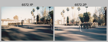
Photograph - Army Survey Regiment - Regimental Training Military Skills Revision, c1984
This is a set of 25 photographs of the Army Survey Regiment personnel undertaking military skills revision, at the Army Survey Regiment, Fortuna, Bendigo, c1984. It is evident in the photos that they participated in lessons on the handling of the M30 Grenade and SLR Rifle, and lessons in first aid.This is a set of 25 photographs of the Army Survey Regiment undertaking military skills revision, part of Regimental Training at Fortuna Villa c1984. Colour photos are printed on photographic paper and scanned at 300 dpi. The photos are also stored on 35mm negative film. They are part of the Army Survey Regiment’s Collection. .1) & .2) - Photo, colour, c1984. Pre-training briefings on the parade ground. .3) - Photo, colour, c1984. Rifle revision training. L to R: unidentified personnel, WO2 Ralph Chant – instructor, SGT John Zuringer – instructor. .4) & .5) - Photo, colour, c1984. Rifle revision training. L to R: unidentified personnel, WO2 Ralph Chant – instructor. .6) - Photo, colour, c1984. Rifle revision training. L to R: WO2 Tony Clark – instructor, unidentified, SPR Sherri (Dally) Burke, CPL Robin Marshall, CPL Roger Pearson, SPR Bob Hopper, unidentified, CPL Dan Cirsky. .7) - Photo, colour, c1984. Rifle revision training. WO2 Tony Clark – instructor. .8) to .14) - Photo, colour, c1984. Hand grenade training. Unidentified soldier throwing grenade. .15) - Photo, colour, c1984. Hand grenade training. L to R: unidentified (x2) SPR Jann (Caithness) Lambdon-Young throwing grenade, WO2 Ian ‘Rock’ Thistleton. .16) - Photo, colour, c1984. Hand grenade training. L to R: unidentified soldier throwing grenade, WO2 Ian ‘Rock’ Thistleton. .17) - Photo, colour, c1984. Hand grenade training. L to R: unidentified, unidentified soldier throwing grenade. .18) - Photo, colour, c1984. Navigation revision L to R: CPL Gary Tremain, SPR Jim Humphrey. .19) & .20) - Photo, colour, c1984. Navigation revision. Unidentified personnel. .21) - Photo, colour, c1984. Navigation revision. SPR Tracy (Parker) Ash. .22) - Photo, colour, c1984. Navigation revision. Unidentified (x2), CPL Gary Tremain. .23) - Photo, colour, c1984. Navigation revision. L to R: CPL Lorraine (Daly) Talbot-Smith, SPR Jim Humphrey, unidentified (x4), SGT Gavin Neilson. .24) - Photo, colour, c1984. Navigation revision. L to R: CPL Lea-anne (Smallshaw) Shirley, CPL Lorraine (Daly) Talbot-Smith, unidentified, CPL Gary Tremain, unidentified. .25) - Photo, colour, c1984. First Aid revision. L to R: SGT Bruce Wetzig – instructor, CPL Ken Peters, unidentified..1P to .25P No personnel are identifiedroyal australian survey corps, rasvy, army survey regiment, army svy regt, fortuna -
Glenelg Shire Council Cultural Collection
Functional object - Oar, n.d
The oard comes from the SS Casino. The SS Casino was a screw steamer which launched from Dundee, Scotland in 1882. It was built to order for the NSW North Coast Sydney by Mr B. B. Nichol of the Newcastle and Hunter Steam Navigation Company. On its delivery voyage it stopped in Warrnambool where it was sighted by the owners of the Belfast and Koroit Steam Navigation Company who were seeking a vessel. They successfully bid for it and bought it for 14,250 pounds. In 1932 the SS Casino ran aground just off the coast of Apollo Bay.S S CasinoRowing oar, timber, repainted marked 'casino' on blade. Oar has had another section of shaft and handle added.Front: on blade 'CASINO' Back: -s s casino, shipwreck, oar, 1900s -
 Mission to Seafarers Victoria
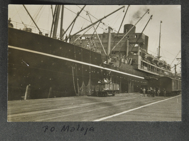
Photograph - Photograph, Sepia, P.O. Maloja, 1928
The SS Maloja was a passenger liner operated by The Peninsular and Oriental Steam Navigation between 1923 and 1954. The ship was requisitioned by the Admiralty for service as an Armed Merchant Cruiser upon her arrival at AdenB & W landscape photograph with view from the dock of nearside port bow and superstructure of a moored ship. Men at dockside level are loading or unloading with net in foreground. railway vehicles are lined alongside under a shed. A faint series of letters can be made out near the portholes towards top of bow. This could be name of the vessel. Handwritten in black ink beneath lower edge of image on album page as "P O Maloja" (this may be misnamed) see notes belowsteam ships, world war 2, p.o. maloja, ss maloja, p & o, peninsular and oriental steam navigation company, fan album -
 Lakes Entrance Historical Society
Postcard - Kalimna Jetty, 1925c
Hand coloured postcard showing the S S Gippsland leaving Kalimna Jetty. Jetty has two sheds on north end of jetty belonging to Kalimna Hotel. Navigation light on south end of jetty. M V Sagitassein lower right corner of photo. Jemmys Point in background with road cutting visible. Kalimna Lakes Entrance VictoriaKalimna Jettyships and shipping, waterways, jetties, boating -
Moorabbin Air Museum
Magazine (Item) - Deleted
Description: Models EMB-110K1 EMB-110P1 EMB-110 P2 Technical Radio Navigation T.O.IC95A-2-9 Level of Importance: . Historical Details: Missing Jan 1968 to Dec 1977 -
 Vision Australia
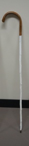
Functional object - Object, White cane with brown handle
Another example of a painted white cane, made from a tree branch stripped of lateral buds, but with a metal tip indicating its primary use as a navigation device rather than a support stick.Wooden white cane with crooked handle with metal tipassistive devices, white caned -
 Federation University Historical Collection
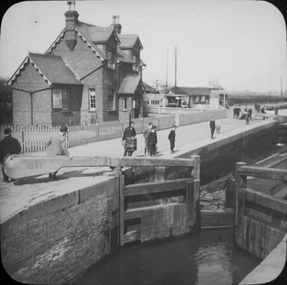
Photograph - Glass Plate, Henry Sutton, Hertford Lock by Henry Sutton, c1891
Henry Sutton was born in Ballarat into the musical Sutton Family. He is known as an important Australian inventor. Photograph of Hertford Lock. lockkeepers house. A lock is a device used for raising and lowering boats, ships and other watercraft between stretches of water of different levels on river and canal waterways. Hertford Lock is situated on the River Lea on the eastern side of Hartham Common, Hertford in the English county of Hertfordshire. It is owned and managed by British Waterways and is the first lock of the River Lee Navigation.henry sutton, glass plates, photography, swans -
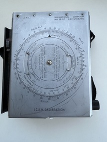 Moorabbin Air Museum
Equipment (Item) - Navigational Computor MK III D Ref. No. 6B/180
-
Moorabbin Air Museum
Archive (Item) - Box WP8 Prowse Collection See details under Description Section
Description: Turbomeca leaflet Airvan leaflet (12 copies) Flight Computer - US Army Airforces RAAF Defence Instruction AAP 7214-003-4-11 Instrument Systems - IPB Sleigh News Dec 78 Jindivik Project Production Bulletins - Various Flight Manual - Jindivik Mk 3A A Level of Importance: State. -
 Mission to Seafarers Victoria
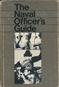
Book, Naval Institute Press, The Naval Officer's Guide, 1970
509 pages, illustrated , navy linen cover with light blue dust jacket.non-fictionhoward timbury, first fleet fellowship victoria, interest group, education, navigation -
 Mission to Seafarers Victoria
Book, Naval Institute Press, Standard Seamanship for the Merchant navy, 1970
509 pages, illustrated , navy linen cover with light blue dust jacket.non-fictionhoward timbury, first fleet fellowship victoria, interest group, education, navigation -
 Mission to Seafarers Victoria
Photograph - Photograph, Black and White, mid 20th C
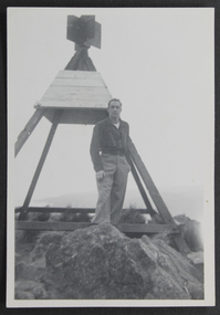
Appears to have been taken mid 20th C. the trig point is similar to those found around Australia but location yet to be confirmed.Mariner Duncan had a particular regard for the Mission to Seafarers. A plate for display on a commissioned new table at the MTSV acknowledges his bequest and the material donated. Collectively the G W Duncan material includes: photographs, professional data memorabilia and written and commercially printed resources. The memorabilia relates to his career at sea and in particular the role of an engineer, including a handwritten manual of notes and references relating to the mechanical and engineering aspects and areas of responsibility for maintenance. small b & w photograph depicting male figure in casual shirt and trousers standing next to a Trig point on rocks near a coast. ID of figure tbc.trig points, navigation, george winfield duncan (1922-2017), ship engineer, s.s. athenic -
 Mission to Seafarers Victoria
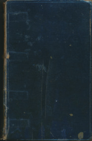
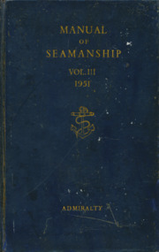
Book, Her Majesty's Stationery Office, Manual of Seamanship Vol.3 1951, 1951
The Manual of Seamanship is divided into three volumes. Volume III comprises information on the more advanced aspects of seamanship, and is intended as a book of reference for seamen of experience.484 pages, illustrated, navy glossy paper cover with embossed golden anchor and no dust jacket.non-fictionThe Manual of Seamanship is divided into three volumes. Volume III comprises information on the more advanced aspects of seamanship, and is intended as a book of reference for seamen of experience.howard timbury, first fleet fellowship victoria, interest group, navigation, education -
 Mission to Seafarers Victoria
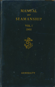
Book, Her Majesty's Stationery Office, Manual of Seamanship Vol.1 1951, 1954
Volume I is a practical guide for executive officers covering the syllabus laid down for examination in navigation and pilotage for the rank of Lieutenant, but omitting the study of nautical astronomy and meteorology.536 pages, illustrated, navy glossy paper cover with embossed golden anchor and no dust jacket.non-fictionVolume I is a practical guide for executive officers covering the syllabus laid down for examination in navigation and pilotage for the rank of Lieutenant, but omitting the study of nautical astronomy and meteorology.howard timbury, first fleet fellowship victoria, interest group, navigation, education -
 Mission to Seafarers Victoria
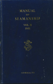
Book, Her Majesty's Stationery Office, Manual of Seamanship Vol.2 1951, 1954
Volume I is a practical guide for executive officers covering the syllabus laid down for examination in navigation and pilotage for the rank of Lieutenant, but omitting the study of nautical astronomy and meteorology.536 pages, illustrated, navy glossy paper cover with embossed golden anchor and no dust jacket.non-fictionVolume I is a practical guide for executive officers covering the syllabus laid down for examination in navigation and pilotage for the rank of Lieutenant, but omitting the study of nautical astronomy and meteorology.howard timbury, first fleet fellowship victoria, interest group, navigation, education -
Glenelg Shire Council Cultural Collection
Functional object - Telescope, n.d
Telescope belonging to Captain James Fawthrop who was harbour master at Portland and also the Captain of the Portland Lifeboat at the time it rescued survivors from the wreck of the Admella in 1859.Belonged to Captain James FawthropTelescope made of wood and brass, originally belonging to Captain James Fawthrop. Measures approx. 40 cm extended and 15 cm when closed.james fawthrop, telescope, navigation, admella, portland lifeboat