Showing 2589 items matching "aerial"
-
 Beechworth Honey Archive
Map- Everton
Map compiled from 1975 aerial photography. Printed in 1979.Map shows Everton, Ovens River, Beechworth- Wangaratta Rd, former Wangaratta- Bright railway. Scale 1:25,000. Printed colour on paper.Map labelled Everton. No. 8225-3-3.map, everton, ovens river, bright, railway, aerial, photography, paper, beechworth honey -
Whitehorse Historical Society Inc.
Map, Melbourne Metropolitan Area Base Map, 1957?
Sheet 254 of part of the Municipality of Nunawading and part of the Parish of Nunawading, showing roads, block numbers, creeks and contours mostly south of Canterbury Road.Sheet 254 of part of the Municipality of Nunawading and part of the Parish of Nunawading, showing roads, block numbers, creeks and contours mostly south of Canterbury Road. Prep. from State Aerial and Cadastral survey information, August 1957. Scale: 400 ft = 1 inchSheet 254 of part of the Municipality of Nunawading and part of the Parish of Nunawading, showing roads, block numbers, creeks and contours mostly south of Canterbury Road. city of nunawading, cadastral -
 Friends of Ballarat Botanical Gardens History Group
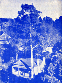
Work on paper - Adam Lindsay Gordon, Australian Poet, Souvenir from Adam Lindsay Gordon's Cottage, Unknown
This leaflet gives a chronology of Gordon's life and a photograph of him. And printed on the other side, besides the aerial view of the cottage is a paragraph about the two years he spent in the cottage, 1867-1868 three short extracts of his poetry.Documents available and newspaper extracts make it clear that some Ballarat Citizens were proud of their city's association with this poet. 1 yellow leaflet printed on both sides in blue, with a photo of Gordon on the right side of p.1 and an aerial view of the Cottage off-centre on p.2. Originally folded twice.Noneadam lindsay gordon, adam lindsay gordon cottage, john garner, doctor, ballarat botanic gardens, craig's hotel, australian poet, friends of ballarat botanical gardens, john garner collection, poet, gardens, ballarat -
City of Kingston
Photograph - Black and white, 20 December 1945
This aerial image covers a section of Cheltenham, with a large paddock yet to be converted to an industrial and later a commercial zone.This aerial photograph provides evidence of the changing landscape of Cheltenham and Highett since WWII. Photographed in 1945, the image features a large block of land now the site of site the major transformation of Cheltenham with the development of the Southland shopping centre in the 1960s and expansion in the 1990s.Aerial photograph of the Cheltenham area in the City of Kingston. This 1945 image is concentrated on the area between Bay Road and Garfield Lane with the distinctive bend into Jean Street. A large block of land runs between the Nepean Highway and the rail line. This is now the area occupied by the extension of Southland in the 1990s.cheltenham, southland, aerial photograph, highett -
 Parks Victoria - Wilsons Promontory Lightstation
Radio
Type used by RAAF Radar station (RS 14) for backup communications 1942 - 1946. This one is an AT5 radio aerial coupling unit with black face and dials and switches. They functioned as a set and were manufactured in 1938 at the Ashfield, Sydney workshop of AWA (Amalgamated Wireless Australasia Ltd, later AWA Ltd), Australia’s largest electronics manufacturer and broadcaster. They are rare outside Australia as they were seldom exported to other air forces, and remained in service until the late 1950s.202 An AT5 transmitter and AT5 coupling unit are held in Sydney’s Powerhouse Museum.203 The three units in the Wilsons Promontory Museum were deployed by the RAAF in WWII and represent the types of communications equipment used at the 14 Radar Station, Wilsons Promontory. It is not known, however if these particular examples were used at the lightstation and are part of the same set. They have interpretive relevance to the collection, but their significance to the lightstation is dependent on whether they have a direct historical association with the radar station that operated there. The units will have first level contributory significance if it is confirmed they were used at the Wilsons Promontory Radar Station.radio aerial coupling unit grey metal face with multiple dials & switches -
City of Kingston
Photograph - Black and white, 20 December 1945
This aerial image covers a section of Cheltenham, with a large paddock yet to be converted to an industrial and later a commercial zone.This aerial photograph provides evidence of the changing landscape of Cheltenham and Highett since WWII. Photographed in 1945, the image features a large block of land now the site of site the major transformation of Cheltenham with the development of the Southland shopping centre in the 1960s and expansion in the 1990s.Aerial photograph of the Cheltenham area in the City of Kingston. This 1945 image is concentrated on the area between Bay Road and Garfield Lane with the distinctive bend into Jean Street. A large block of land runs between the Nepean Highway and the rail line. This is now the area occupied by the extension of Southland in the 1990s. It is a negative version of VKHC124.cheltenham, southland, market garden -
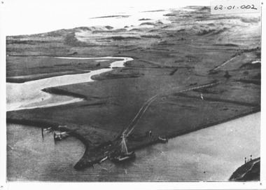 Port Fairy Historical Society Museum and Archives
Photograph, c. 1925
Black and white aerial of Martins Point Moyne River showing dredge. The original signed by R. W. Golding.Black and white landscapelocal history, photography, photographs, slides, film, aerial, martins point, moyne river, dredge -
Whitehorse Historical Society Inc.
Document, Horticultural Heritage Advice, 1/11/2002 12:00:00 AM
A list of significant trees.A list of significant trees at 5 Longland Rd, Heatherdale, 449 Springvale Road, Forest Hill, 129 Mount Pleasant Road, Forest Hill and 347 Blackburn Road, Burwood East including aerial photographs by Francine Gilfedder & Associates.A list of significant trees. heritage studies, horticulture, longland road, heatherdale no. 5, springvale road, forest hill no. 449, mount pleasant road, forest hill no. 129, blackburn road, burwood east no 347, gilfedder francine -
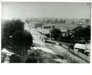 City of Kingston
Photograph - Black and white, Percy Fairlam, c. 1910
Black and white image of Cheltenham in the early 20th Century depicts an almost idyllic life. This photo was taken by Percy Fairlam, who climbed a tall pine tree to achieve the aerial view. The tree was a well recognised feature of the Cheltenham skyline but was cut down some time before World War II.Cheltenham was established as a rural market gardening community. The development of the railway was crucial to the ongoing development of the area. Community life sprung up around the railway line which is evident in the proximity of shopping and leisure.Black and white image depicting aerial view down Charman Road, Cheltenham, including the unsealed road, level crossing and shopping centre. What appears to be a cricket pitch is located behind the shops.Handwritten in black ink on a red round sticker adhered to the reverse, and then crossed out: X14 Handwritten in blue ink on reverse: A8 Handwritten in red ink on reverse: 85%cheltenham, railway crossing, roads, housing, shopping strip -
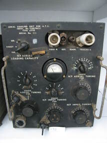
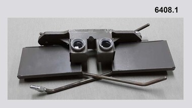 Bendigo Military Museum
Instrument - Universal Stereoscope, 1940
The Universal Stereoscope was used to view overlapping stereo aerial photography in three dimensions (3D). It consists of magnifying lenses, an optical train including glass prisms and mirrors that are protected by sliding metal covers all suspended on a pair of fold out adjustable legs. The stereoscope is coloured military olive drab green. This Universal Stereoscope was produced in Australia in 1940 for Military use. It was originally produced with a timber protecting carry box that is missing. It was used extensively by members of the Australian Survey Corps during WWII in many theatres of War for viewing and annotating aerial photography. Item 6205.6P, photograph 6205.1P shows the Universal Stereoscope in use by the Australian Survey Corps annotating aerial photography.The Universal Stereoscope was used to view overlapping stereo aerial photography in three dimensions (3D). It consists of magnifying lenses, an optical train including glass prisms and mirrors that are protected by sliding metal covers all suspended on a pair of fold out adjustable legs. The stereoscope is coloured military olive drab green."DC-1940 Serial No 550", "D V D", "Made in Australia" Plate on the underside reads " This stereoscope was donated to the Ex Fortuna Survey Association by the Eaglehawk Recycle Shop February 2015"royal australian survey corps, rasvy, fortuna, army survey regiment, army svy regt, asr -
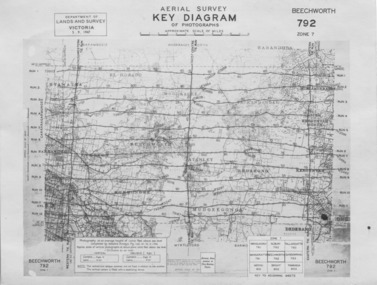 The Beechworth Burke Museum
Photograph - Aerial Survey, 5/9/1947
This image is an Aerial Survey, Key Diagram of Beechworth and surrounding area. Issued by Department of Lands and Survey, Victoria in 1947. Photographed at an average height of 12300 feet above sea level, areas depicted are; Beechworth, Stanley, Bruarong, Baranduda, Muagegonga, Myrtleford, Everton, Wooragee North Tarrawinge, Dederang, Kergunyah North, Kergunyah, Yackandandah, El-Dorado, Barambogie, Murmungee, Barwidgee, Oxley, CarraragarmungeeBlack and white rectangular photograph. Image is printed on matt photographic paper and has a white un-printed border. Obverse: AERIAL SURVEY, KEY DIAGRAM OF PHOTOGRAPHS, APPROXIMATE SCALE OF MILES / DEPARTMENT OF LANDS AND SURVEY VICTORIA 5.9.1947. BEECHWORTH 792 ZONE 7. Reverse: BMM7010.1 (written in pencil) aerial survey, beechworth, burke museum, department of lands and survey, victoria, 1947 -
Whitehorse Historical Society Inc.
Map, M.M.B.W, c1962
Melbourne Metropolitan Area Base Map series sheet 235, covering part, Mitcham, Nunawading and Ringwood areas.Melbourne Metropolitan Area Base Map series sheet 235, covering part, Mitcham, Nunawading and Ringwood areas. Prepared by Department of Lands and Survey and Melbourne and Metropolitan Board of Works from State aerial Survey, June 1957 and Cadastral Survey information, August 1960. Scale 1:4,800.Melbourne Metropolitan Area Base Map series sheet 235, covering part, Mitcham, Nunawading and Ringwood areas. maps, mitcham, nunawading, ringwood, melbourne and metropolitan board of works, victoria. department of lands and survey -
Phillip Island and District Historical Society Inc.
Photograph, circa 1940
Commercially printed approx 1940s. Bayview Guesthouse (lower right foreshore) was burnt down in 1950s.Jetty diagonally lower left - township in foreground - open paddocks in background. Thompson Avenue & Cypress trees lower middle to upper right. Taken approx 1940sAerial view of Cowes Phillip Island No. 147local history, photography, photographs, slides, film, aerial views of cowes, phillip island, black & white photograph, aerial views cowes -
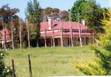 Stawell Historical Society Inc
Photograph, “MORAY” Residence on Crowlands Road Stawell
Residence - “MORAY” Crowlands Road Stawell3 photos 1 black and white 2 colour of house Moray on Landsborugh Rd Stawell-2 Moray Stawell 1985. Aerial View.stawell -
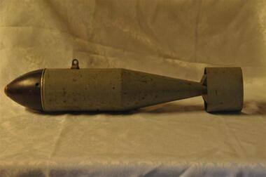 Running Rabbits Military Museum operated by the Upwey Belgrave RSL Sub Branch
Bomb Aerial
Aerial Bombammunition, c1960, raaf -
Creswick Campus Historical Collection - University of Melbourne
Still Image, 1964
Subject: Lower Glenelg Plantation . 7 brown envelopes marked Run 1. No. 12 - 17of 9 prints each. Stored in a brown cardboard file box marked Lower Glenelg Plantation Run No.1. 11 - 17(x9). Photos commissioned by Forests Commission Victoria 1964.Aerial Photographs -
Creswick Campus Historical Collection - University of Melbourne
Still Image, 1962
Subject: Kuark- McKenzie Crk Project . 5 brown envelopes marked Run 1A - Run 5 of 10 prints each. Stored in a brown cardboard file box marked Kuark- McKenzie Crk Project. Photos commissioned by Forests Commission Victoria 1962.Aerial Photographs -
Creswick Campus Historical Collection - University of Melbourne
Still Image, 1966
Subject: Creswick . 9 brown envelopes marked Run 6. containing c 80 marked up photos. Numbers 30 to 50, 88 - 91 in sequence. Stored in a brown cardboard file box . Photos marked on rear as on loan from the Photographic Library of theForests Commission Victoria . pencilled in date "1946?" on one envelope.Aerial Photographs -
Creswick Campus Historical Collection - University of Melbourne
Still Image, 1962
Subject: Ballarat-Creswick Plantations Block A . 4 brown envelopes marked Run 4 No. 135 - 138 of c.30 prints total. Marked up with red pen. Stored in a brown cardboard file box marked Errinundra Project..Combien Project...Ballarat Plantation. commissioned by Forests Commission Victoria 1962.Aerial Photographs -
Creswick Campus Historical Collection - University of Melbourne
Still Image, 1958 -1967
Subject: Calder Ridge Project . 3 brown envelopes marked Run 2 c.26 prints total. 1967. Subject: Mt Cole Mt Lonach 1958. 1 brown envelopes marked Run 4. c.15 prints total. Subject: Colac 1966 . 1 brown envelopes marked Run 6 c.8 prints total. Subject: Mt Tamoritha, Mt Arbuckle. 1966. 1 brown envelopes marked Civil AS-FRI-FCV-APMF CO-OP project no. 13.23 - 13.38 c.18 prints total. Stored in a brown cardboard file box marked as per contents.Aerial Photographs -
Creswick Campus Historical Collection - University of Melbourne
Still Image, 1956
Subject: Ballarat-Creswick Plantations Block A . 9 brown envelopes marked Run 3 No. 84 - 92 of c.76 prints total. 1 brown envelopes marked Run 4 No. 127-136 of 9 prints total. 1956. Marked up with red pen. Stored in a brown cardboard file box marked Ballarat-Cres.Plantation Block A. Run 3.Aerial Photographs -
Creswick Campus Historical Collection - University of Melbourne
Still Image, 1964 - 1966
Subject: Combienbar River Project. 1964. 2 brown envelopes marked Run 16, 17 of c.18 prints total. Subject: Errinundra Project. 1966. 2 brown envelopes marked Run 12, 13 of c.14 prints total. Stored in an unmarked brown cardboard file box . Related to item 1507. Marked Errinundra Project..Combien Project...Ballarat Plantation.Aerial Photographs -
Creswick Campus Historical Collection - University of Melbourne
Still Image, 1956
Subject: Ballarat-Creswick Plantations Block A . 1956. 9 brown envelopes marked Run 4 No. 127 - 139 of c.75 prints total. Stored in a brown cardboard file box marked Creswick Run.6.Aerial Photographs -
Creswick Campus Historical Collection - University of Melbourne
Still Image, 1956 -1968
Subject: Creswick 1956 . 8 brown envelopes marked Run 4 -3 No. 31 - 42 of c.45 prints total. 2 empty brown envelopes marked run 4 no.38 -39, and run 6 no. 85-87. 5 loose black and white prints. Subject: Lower Glenelg Plantation . 2 brown envelopes marked Run 1. No. 26-27. Stored in a brown cardboard file box marked Creswick 1968 Project.Aerial Photographs -
Creswick Campus Historical Collection - University of Melbourne
Still Image, 1948 - 1956
Subject: Coffs Harbour 1956 . Subject: Grampians no. 11-15. Subject: Kinglake area 1948 -1950 Run 7 no.14 - 16, Run 8 no.69 -70 . Subject: Princetown Run 7 . Subject: South Gippsland Run 7 no.102 - 105. Subject: Otway area. Stored in 5 brown envelopes in a brown cardboard file box marked "INTERPRETATIONS. South Gippsland .......Otway area prints"Aerial Photographs -
Creswick Campus Historical Collection - University of Melbourne
Still Image, 1956 -1968
Subject: Creswick 1968 Project . 10 brown envelopes marked Run 1 -3. Run 6. No.s missing sequences. c.50? prints total. Mix of black and white and colour. Range of dates. Stored in a brown cardboard file box marked Creswick 1968 Project Run 1 24 - 27. 2. 42 - 47. 3. 32-33Aerial Photographs -
Creswick Campus Historical Collection - University of Melbourne
Still Image, 1990
Subject Creswick. Colour.Aerial Photographs -
 National Vietnam Veterans Museum (NVVM)
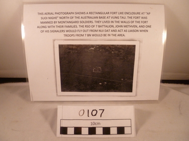
Photograph, Suoi Nghe, 7RAR
A reprinted black and white Photograph of an area with a small rectangle area in the middle and the road goes down from below middle left side to near bottom on the right side. Above the photograph reads: This aerial photograph shows a rectangular fort like enclosure at "Ap Suoi Nghe" North of the Australian Base at Vung Tau. the fort was manned by Montagnard soldiers who lived with their families within the walls of the village. The Reception, Staging, and Onward Movement (RSO) of 7 Battalion, John Methven, and one of his signalers would fly out from Nui Dat and act as liaison when troops from 7 BN would be in the area.A reprinted black and white Photograph of an area with a small rectangle area in the middle and the road goes down from below middle left side to near bottom on the right side. Above the photograph reads: This aerial photograph shows a rectangular fort like enclosure at "Ap Suoi Nghe" North of the Australian Base at Vung Tau. the fort was manned by Montagnard soldiers who lived with their families within the walls of the village. The RSO of 7 Battalion, John Methven, and one of his signalers would fly out from Nui Dat and act as liaison when troops from 7 BN would be in the area.This aerial photograph shows a rectangular fort like enclosure at "Ap Suoi Nighe" north of Australian base at Vung Tau. The fort was manned by montangard soldiers. They lived in the walls of the fort along with their families. The RSO of 7 Battalion, John Methven and one of his signalers would fly out from Nui Dat and act as liaison when troops from 7 BN woul be in the area.7 rar, 7 battalion map, john methven, montagnard, suoi nghe, signals, photograph, ap suoi nghe, vung tau, montagnard soldiers, nui dat, 7 battalion, rso -
Whitehorse Historical Society Inc.
Pamphlet, Maroondah Highway, Nunawading, 1/10/1999 12:00:00 AM
Auction brochure for 360 Maroondah Highway, Nunawading [Whitehorse Road].Auction brochure for 360 Maroondah Highway, Nunawading [Whitehorse Road]. 3 lots for auction, 27 October 1999. Agent; Collier. Site of the former Nunawading Council Chambers. Includes aerial photo of Nunawading including Whitehorse Rd / Springvale Rd corner and Nunawading Railway Station area.Auction brochure for 360 Maroondah Highway, Nunawading [Whitehorse Road]. whitehorse road, nunawading, no 360, city of nunawading. council chambers, municipal chambers, springvale road, nunawading, nunawading railway station -
 Bendigo Historical Society Inc.
Photograph - WES HARRY COLLECTION: AERIAL VIEW OF BENDIGO CBD, 1966
Aerial photograph of the Bendigo CBD. On the reverse is written : 'City of Bendigo 1966, State aerial Surveyplace, aerial view of bendigo, cbd, bendigo cbd, aerial survey of victoria