Showing 3394 items
matching black horse
-
 4th/19th Prince of Wales's Light Horse Regiment Unit History Room
Information Sheet, 2 copies, Squadron Tactical Signs
A piece of yellow A4 paper displaying the shape and dimensions for the tactical signs for RHQ & HQ Squadron, A, B, and C Squadrons in black. The sheet is a copy from another publication.armoured tactical signs -
 Ararat & District Historical Society (operating the Langi Morgala Museum)
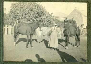
Photograph, c.1920
This photograph is of a local identity, known as Dorrie, who lived and studied in the Ararat community in the late 1920s.Black-and-white photograph of a woman holding two horses by their reins outside of a house surrounded by picket fence and trees. Shadows appear in the foreground where the photographer would have been standing with their back to the sun. Rear: "To dear Miss Norman / With fondest love from / Dorrie".horses, homestead, ararat, dorrie, 1920 -
 Ararat & District Historical Society (operating the Langi Morgala Museum)
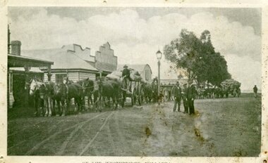
Photograph, Willaura Weighbridge
This photograph shows a point in time (late 19C) at the Willaura weighbridge which no longer exists. The weighbridge was part of a transportation system that included horses, wagons, silos, and trains and when this photograph was taken, the weighbridge was crowded with people and wagons. Black and white photograph of a streetscape with wide dirt roads, some early European buildings and three supply wagons. Two are horse drawn and the third is pulled by bullock, with six men driving the wagons and standing in the roadway. Front: "Willaura Weighbridge"willaura, weighbridge, postcard, horses, wagons, wool, transport -
 Ararat & District Historical Society (operating the Langi Morgala Museum)
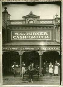
Photograph, 30 July 2008
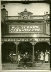
Locally significant because it shows a business in the early days of the town.Black and white photograph on cardboard showing four males and a female standing with a horse and cart in front of a shop. The shop is branded with the name W.G. Turner Cash and Grocer and has the year 1857.Handwritten on back of photograph is "formally Fred Thompson's Grocers shop" and "Bill Bowker, Bill Grant, Joyce Trevan, ?, Bill Turnerararat, business, fred thompson grocer, w.g. turner cash and grocer -
 Ararat & District Historical Society (operating the Langi Morgala Museum)
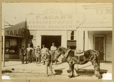
Photograph
Black and white photograph showing six men, a horse and dog outside F. Acars' blacksmith shop. The men are all wearing hats. Photo is mounted on cardboard. -
 Ararat & District Historical Society (operating the Langi Morgala Museum)
Photograph
A Barkly Street business built in 1857Black and white photograph of W.G. Turner Cash and Grocer Store. Four men and a woman stand in front of the store with a horse hitched to a cart. The photo is printed on cardboard.Written on back: Formerly Fred Thompson's Grocers Shop. And: Bill Bowker, Bill Grant, Joyce Treven, Bill Turner -
 Ararat & District Historical Society (operating the Langi Morgala Museum)
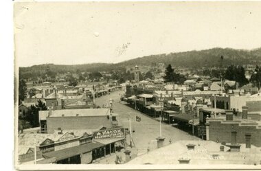
Postcard
A black and white photographic postcard of a view of Barkly Street with Copes Hill in the background. Photo taken from Town Hall. Horse drawn vehicle in street scene. Shop front signs legible: A. Waugh Ready Money Draper, Albion Hotel, aganet for Brunnings, TRG Williams Photographer, E.I. Beynan, Fergusson's. -
 Ararat & District Historical Society (operating the Langi Morgala Museum)
Photograph
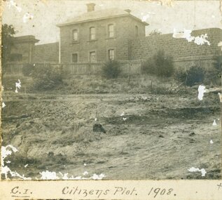
Record of local historyA series of three black and white photographs of the Citizens Plot at Alexandra Gardens. 501 shows the bluestone building J Ward standing behind a wooden picket fence with bare earth in front. 502 shows men in suits standing with three horses attached to two wagons with large trees in the background. 503 shows plants that have grown in the Citizens Plot garden.501: Citizens Plot 1908 502: Citizens Plot 1909. 503: Citizens Plot showing growth 1921. -
 Eltham District Historical Society Inc
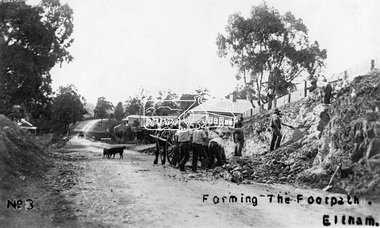
Photograph, Tom Prior, Forming the footpath, Eltham, c.1906
Photo: Tom Prior (brother of Mrs Ernest Richard Reynolds) using his home-made camera. Shows Richard Reynolds' cart and horses (Old Mac and Punch) and the Reynolds' dog. Gahan house on left. Bakery on right at corner of York Street. This image was used in August 1971 issue of Australian Municipal JournalThis photo forms part of a collection of photographs gathered by the Shire of Eltham for their centenary project book,"Pioneers and Painters: 100 years of the Shire of Eltham" by Alan Marshall (1971). The collection of over 500 images is held in partnership between Eltham District Historical Society and Yarra Plenty Regional Library (Eltham Library) and is now formally known as the 'The Shire of Eltham Pioneers Photograph Collection.' It is significant in being the first community sourced collection representing the places and people of the Shire's first one hundred years. The Reynolds family were early settlers in Research. The Reynolds/ Prior collection of photographs were taken by Tom Prior, the maternal uncle of Ivy Reynolds, around 1900 and the 60 photos in the album give a fine overview of many of the landmarks of Research and Eltham over 100 years ago. lvy lived in the family home for many years at 106 Thompson Cres Research. Ivy's father, Ernst Richard Reynolds and grandfather, Richard Reynolds, lived at the same address. Ivy's father Richard worked for Mr. Trail on his property in Research. Reynolds Road is named after the family. Mr Tom Prior (wife Eva) worked at the Melbourne zoo. He was very innovative and made his own camera, using the black cloth hood to exclude the light. The photographs are a reminder of the rural nature of Research and Eltham and its rich heritage.Digital image (4 x 4 inch B&W neg copy missing)shire of eltham pioneers photograph collection, eltham, main road, australian municipal journal august 1971, dudley street, gahan house, maria street, old mac (horse), punch (horse), reynolds prior collection, richard reynolds, road construction, york street -
 Eltham District Historical Society Inc
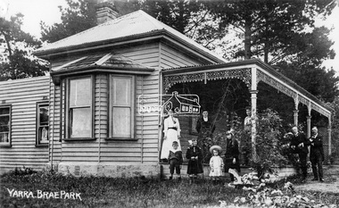
Negative - Photograph, Yarra Brae Park, c.1900
Weatherboard house with cast ironwork decoration on the verandah. Three women, two men and four children with rocking horse stand for a photograph. Family unknown. Yarra Brae Park was situated on Yarra Brae Road, off Sweeneys Lane, Eltham. Research in historical newspapers reveals that the Hautrive family lived there 1904-1906, followed by the Bindoon family in 1907. In the 1930s it was occupied by Hubert Rutter, his wife Beulah and four children. Hubert was an Eltham Shire Councillor. On 13 January 1939, the house burned down in the Black Friday bushfires. After the fire, the family relocated to Toorak. Reproduced on p91 of 'Pioneers & Painters'This photo forms part of a collection of photographs gathered by the Shire of Eltham for their centenary project book,"Pioneers and Painters: 100 years of the Shire of Eltham" by Alan Marshall (1971). The collection of over 500 images is held in partnership between Eltham District Historical Society and Yarra Plenty Regional Library (Eltham Library) and is now formally known as 'The Shire of Eltham Pioneers Photograph Collection.' It is significant in being the first community sourced collection representing the places and people of the Shire's first one hundred years.Digital image 4 x 5 inch B&W Neg Sepia postcard and B&W printsepp, shire of eltham pioneers photograph collection, eltham, yarra brae park, verandah, cast iron work, hautrive family, bindoon family, rutter family, pioneers and painters, houses, groups -
![Photograph, Barb, Kev, Don(?), Bet [members of Braithwaite family?]](/media/collectors/4f729f7b97f83e03086018a5/items/59cbc51d21ea8f1190224e97/item-media/5bac3f9d21eb1e1568d4b918/item-fit-380x285.jpg) Eltham District Historical Society Inc
Eltham District Historical Society IncPhotograph, Barb, Kev, Don(?), Bet [members of Braithwaite family?]
Barb, Kev, Don, Bet are named on the back of the photo, which depicts two children and a dog on the back of a cart with harness (normally attached to a horse). "Don" appears to be the same person as "Den [sic] Braithwaite" sitting on the same cart in another photo in the set.Black and white photograph printed with white borders (one of a set of five).den braithwaite -
 Eltham District Historical Society Inc
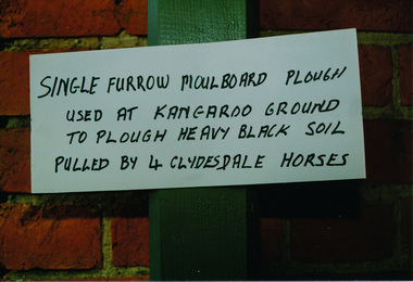
Photograph, Single Furrow Plough, Heritage Week, 1990, 1990
Two colour photographs (same view) of a single furrow plough used at Kangaroo Ground to plough heavy black soil, pulled by four Clydesdale horsesheritage week, eltham, courthouse, single furrow plough, sign, activities -
 Eltham District Historical Society Inc
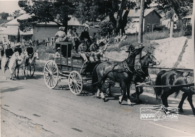
Photograph, Cobb and Co. Coach and horses, ERSILAC Parade, c.1960
... ersilac parade Horse drawn carriage Black and white photograph ...Black and white photograph featuring a Cobb and Co coach drawn by four horses with a full complement of passengers in period clothing. Taken near the old bakehouse at the corner of Main Road and York Street. Part of a procession/parade.cobb and co, bakery, main road, york street, parade, procession, ersilac parade, horse drawn carriage -
 Eltham District Historical Society Inc
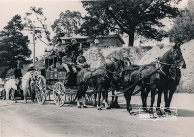
Photograph, Cobb and Co. Coach and horses, ERSILAC Parade, c.1960
Near the corner of Main Road and Bridge StreetBlack and white photograph featuring a Cobb and Co coach drawn by four horses with a full complement of passengers in period clothing. Taken near the corner of Main Road and Bridge Street. Part of a procession/parade.cobb and co, bridge street, ersilac parade, horse drawn carriage, main road -
 Kiewa Valley Historical Society
Photograph from Lake Guy, Bogong Village, Scene from shores of Lake Guy to Mountain range, 1930s to 1950s
In 1940 Field Headquarters for the Kiewa Scheme were established at Bogong with office, workshop facilities and accommodation for workmen, staff and some families constructed. (There had been a 'tent camp' on this site in 1939 but was destroyed by bushfires) Construction of accommodation continued until 1947. A total of 40 houses plus a hostel for single staff, post office, police station, medical centre and primary school all with water and sewerage and electricity supply. The staff hostel was known as Kiewa House and is now occupied by the Education Department. Lake Guy was named after Mr. L.T. Guy who was the Resident Engineer in charge of construction work and associated activities on the Kiewa area. He held this position from 1939 to November 1946 when he was transferred to Head Office.The Bogong Township was developed firstly as an accommodation centre (base camp) for construction workers employed under the Kiewa Hydroelectric Scheme. Due to the influx of European workers into the Township the beautification of the immediate surrounds(gardens etc.) had a distinct European flavour. This environment has been very beneficial for tourism in later years. Strict environmental control has not allowed for any extensive redevelopment in tourist accommodation and basically restricted it to the accommodation initially built for the construction workers. Activities such a bike riding, snow skiing, restricted horse riding and bush walking on the Alpine plains and mountains are now a viable part of the Kiewa Valley Tourist Industry. The lake is one of the many water storage storage reservoirs used to supply the power stations their main power to run the huge turbines generating the final product, electricityThis black and white photograph shot from the shores of Lake Guy toward the mountain range of the Victorian Alps details the early construction of the construction worker's accommodation of the Bogong Village. The paper is of 200gms and is not photographic paper and can be assumed to be a reproduction of an original photobogong village circa 1930 to 1950, kiewa hydro-electricity scheme, victorian alpine region mid 1900s -
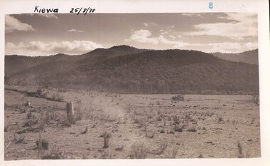 Kiewa Valley Historical Society
Photograph Farm Land, Kiewa, 25/8/38, circa 1938
This photograph was taken in august, 1938 some eight years prior to the establishment of Mt. Beauty as a township. The area was still being used for grazing cattle and the land was eventually acquired from the local land owners by the State Electricity Commission. The construction of the road, from Tawonga to the High Plains, was commenced in April of 1938. This allowed men and heavy equipment to be transported to the work sites for the construction of the Kiewa Hydro Electric Scheme. Prior to this access was by bridle trail, either on horse back or by foot. By 1946 housing construction had commenced for the new town of Mt. Beauty and by 1948 street construction in the southern part of the town was completed as far as Hill Street.This is an important photograph as it shows the upper Kiewa Valley and the site for Mt. Beauty as it was before the establishment of the town. The land has been cleared of natural vegetation and used for grazing cattle.Black and white photograph of farmland, cattle in the distance, hills in the backgroundHandwritten in the upper left hand corner, in black ink, 'Kiewa 25/8/38'. The number 8 has been stamped in the upper right hand side of the photograph. On the back have been stamped the words Velox, indicating the type of photographic paper.kiewa, mt. beauty, construction, grazing, secv -
 Eltham District Historical Society Inc
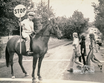
Photograph, Arthur de la Rue, Jock Read on his horse supervising Eltham High School students crossing at Main Road near Dalton Street, Feb 1980, Feb 1980
Published CLIP-CLOP LOLLIPOP Photo: Arthur de la Rue The Age, 22 Feb 1980, p3Black and white photoeltham, jock read, main road, dalton street, eltham high school, school crossing -
 Eltham District Historical Society Inc
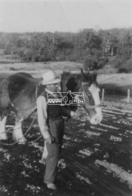
Photograph, Guildo Fabbro, Falkiner Street, Eltham with Clydesdale horse
... guido fabbro bell street clydesdale horse 1 black and white ...Guildo Fabbro, Falkiner Street, Eltham with Clydesdale horse with harness in field. The site of the Fabbro farm (Diamond Creek side land) is now called Barrack Bushlands. It is doubtful that Fabbro's farm holding was ever called Barrak Park, This title is fairly recent after the Shire of Eltham purchased the land, including the last section in 1993/94. About this time the area on the west side of Falkiner Street was purchased by a private developer and developed as housing. The area in Bell Street opposite the Eltham High School was purchased by the State Government is recent years and is called Fabbro Fields. The Fabbro Family operated their farm in Bell Street, Eltham. 1 black and white photographfabbro's farm, guido fabbro, bell street, clydesdale horse -
 Eltham District Historical Society Inc
Photograph, Bend of Islands, c.1926
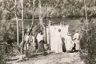
Bend of Islands is named after a group of small islands at a bend of the Yarra River near Watsons Creek. It is located near the town of Kangaroo Ground. The locationn was a long time favourite spot for locals and visitors to fish and swim in the river. This is one of a series of four photographs that depict a mainly young group of people recreating in the area, particularly enjoying horse riding. Possibly weekend campers. Photos taken about 1926-1928. In 1938 "The Argus" advertised weekend cabins at the Bend of Islands estate 5-are Yarra Yarra frontage in the Christmas Hills Gorge ideal for weekend cabins. "Bathing, fishing, canoeing, shooting may be enjoyed in ideal surroundings". This photo seems to be depicitng women waiting to use the shower near the river, or are they going swimming?Black and white photograph (reproduction)Bend of Islands, c.1926 bend of islands, camping, shower block, yarra river, swimming -
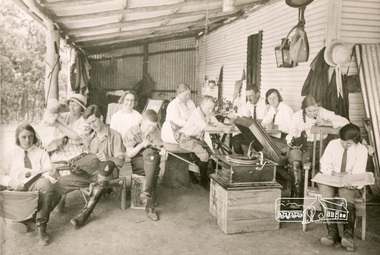 Eltham District Historical Society Inc
Photograph, Bend of Islands, c.1926
Bend of Islands is named after a group of small islands at a bend of the Yarra River near Watsons Creek. It is located near the town of Kangaroo Ground. The locationn was a long time favourite spot for locals and visitors to fish and swim in the river. This is one of a series of four photographs that depict a mainly young group of people recreating in the area, particularly enjoying horse riding. Possibly weekend campers. Photos taken about 1926-1928. In 1938 "The Argus" advertised weekend cabins at the Bend of Islands estate 5-are Yarra Yarra frontage in the Christmas Hills Gorge ideal for weekend cabins. "Bathing, fishing, canoeing, shooting may be enjoyed in ideal surroundings". Was this a church group? This photo depicts individuals "resting" on a verandah undertaking various solo activities including listening to their gramophone.Black and white photograph (reproduction)Bend of Islands, c.1926 bend of islands, camping, recreation, gramophone, group, campers -
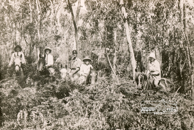 Eltham District Historical Society Inc
Photograph, Bend of Islands, c.1928
Bend of Islands is named after a group of small islands at a bend of the Yarra River near Watsons Creek. It is located near the town of Kangaroo Ground. The locationn was a long time favourite spot for locals and visitors to fish and swim in the river. This is one of a series of four photographs that depict a mainly young group of people recreating in the area, particularly enjoying horse riding. Possibly weekend campers. Photos taken about 1926-1928. In 1938 "The Argus" advertised weekend cabins at the Bend of Islands estate 5-are Yarra Yarra frontage in the Christmas Hills Gorge ideal for weekend cabins. "Bathing, fishing, canoeing, shooting may be enjoyed in ideal surroundings". Black and white photograph (reproduction)Bend of Islands, c.1928 bend of islands, horse riding, camping, tent -
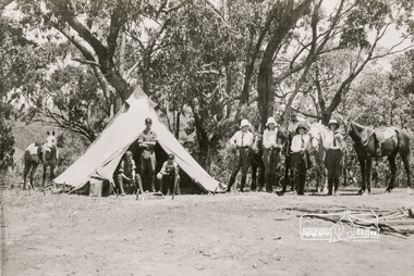 Eltham District Historical Society Inc
Photograph, Bend of Islands
Bend of Islands is named after a group of small islands at a bend of the Yarra River near Watsons Creek. It is located near the town of Kangaroo Ground. The locationn was a long time favourite spot for locals and visitors to fish and swim in the river. This is one of a series of four photographs that depict a mainly young group of people recreating in the area, particularly enjoying horse riding. Possibly weekend campers. Photos taken about 1926-1928. In 1938 "The Argus" advertised weekend cabins at the Bend of Islands estate 5-are Yarra Yarra frontage in the Christmas Hills Gorge ideal for weekend cabins. "Bathing, fishing, canoeing, shooting may be enjoyed in ideal surroundings". Black and white photograph (reproduction)Bend of Islands bend of islands, camping, tent, horse riding -
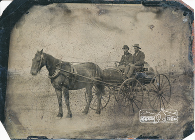 Eltham District Historical Society Inc
Photograph, Two men with horse and buggy
Black and white photograph on tin plate -
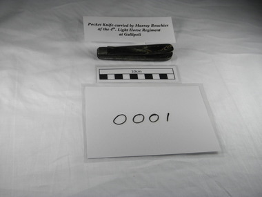 4th/19th Prince of Wales's Light Horse Regiment Unit History Room
Equipment - Pocket Knife, (estimated); Late 19th - early 20th century
Used by Lt Col Murray Bourchier, Commanding Officer 4th Light Horse RegimentTwin bladed pocket knife. Steel construction with black plastic type material on handle. Poor condition, body pin separated at blade end and sides sprung apart. Handle covering chipped on one side. Owner's initials "MB" scratched on handle. gallipoli, 1915, world war 1, pocket knife, bourchier, 4lh, 4th light horse -
4th/19th Prince of Wales's Light Horse Regiment Unit History Room
Regimental Scrap Book: 2000-2009, 2009
Archival quality A3 loose leaf slip case containing memorabilia documents, cuttings and photos about the Regiment for the period 2000-2009. Contents include: Training, ceremonial, social ativities. Black Hat Day 25 March 2001. Exercise Tasman Warrior 2004. Laying up of guidons at Shrine 7 Aug 05. Farewell to the M113 carriers. SECDET deployment Baghdad 2007. Be'er-Sheva Memorial dedication, Israel 28 Apr 2008. Operation Victoria Fire Assist Mar 09.ceremonial, training, guidons, history 4 19 prince of wales s light horse, beersheba, m113, tasmania, israel, black hat day, shrine of remembrance -
4th/19th Prince of Wales's Light Horse Regiment Unit History Room
Gaiters, Not known, 1960 (estimated)
Black canvas Army issue gaiters, with leather straps and brass buckles, eyelets and fittings. Leather binding on lower hem.gaiters, military clothing -
4th/19th Prince of Wales's Light Horse Regiment Unit History Room
Boots, Ankle, Black, 1960 (estimated)
Army issue leather boots, black, ankle length. Half-sole repair, steel toe plate and horseshoe protector in heel, leather laces. boots, army clothing -
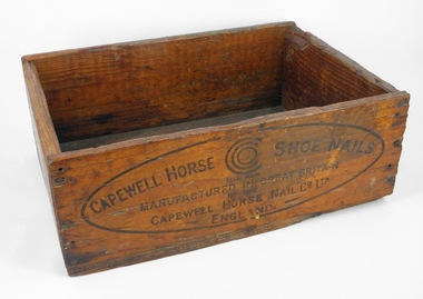 4th/19th Prince of Wales's Light Horse Regiment Unit History Room
Horse Shoe Nail Box, Capewell Horse Shoe Nail Co ltd, (estimated) early 20th century
Wooden Box, used for packing horse shoe nails, open top, clear varnish, labelled with manufacturer's details.Capewell Horse Shoe Nails, Trademark, Manufactured in Great Britain by the Capewell Horse Shoe Nail Co Ltd England. No 7 Horse Nails, Over stencilled with black ink or paint: "Net 100 lb, Gross 116 Full (?) Hunter"box, light horse, horse shoe nails, capewell horse shoe nail co, packaging -
4th/19th Prince of Wales's Light Horse Regiment Unit History Room
Slide Plate, Cinema Advertising, 1980 (estimated)
Glass Plate, 80 x 80 mm, cinema advertising. Orange background. In black borderded 40 x 25 mm rectangle - black print on yellow fill - "Join up 4/19 Prince of Wales Light Horse George Street FITZROY". Next to this message is a picture of M113A1 Armoured Personnel Carrier, under which is "Army Reserve The Ready Men" Note incorrect spelling of unit title: "Wales" instead of "Wales's"advertising, army recruiting, cinema, glass slide, advertising, army recruiting, cinema, glass slide -
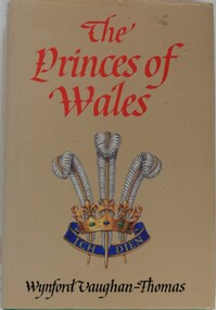 4th/19th Prince of Wales's Light Horse Regiment Unit History Room
Book, Wynford Vaughan-Thomas, The Princes of Wales, 1982
The title of the Regiment includes that of HRH The Prince of Wales and the Regimental badge incorporates the three feathers and motto (Ich Dien) of his crest. This book provides a history of the 21 Princes of Wales from the Black Prince of Battle of Crecy fame to Charles. Hardcover book depicting Prince of Wales insignia on dustcover written about the first 21 Princes of WalesISBN 0 7182 5890 8prince of wales, british history, wynford vaughan thomas, ich dien, prince of wales, british history, wynford vaughan thomas, ich dien