Showing 652 items matching "boat house"
-
 Vision Australia
Photograph - Object, Lorna Lodge, 2004
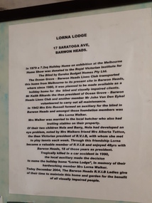
This board was constructed to provide information about the history of Lorna Lodge and to display some photographs and a newspaper cutting relating to this. The photographs are (clockwise): Photograph of Lorna Lodge on December 26, 1969 with a man standing outside and three children on the ramp leading to the front door. Photograph of Miss Elizabeth Skene, oldest member, at the 60th anniversary of the Barwon Heads auxiliary. Newspaper cutting: Ocean Grove News. Luncheon to help the blind. Ocean Grove has its fair share of fundraising groups. And the Royal Victorian Institute for the Blind, Ocean Grove Auxiliary is up there with the most hardworking. Pictured at the auxiliary's recent meeting are president Lorna Walker, secretary Vera Montgomery and treasurer Grace Brown. Talking of fundraising, the auxiliary will hold a casserole luncheon at the Ocean Grove Bowling Club on Monday, June 6 at noon. Tickets are available at the door at $5. Photograph of 60th anniversary in 2002 of RVIB Barwon Heads Mrs Grace Brown President and Yvonne Conners of Geelong West with a cake marking the occasion. Photograph of Bonnie Cameron and Vera Montgomery, RVIB Members holding a picture of the boat shed at Barwon Heads. Photograph of RVIB Life Members Achievement Award, awarded in recognition of support from Barwon Heads Auxiliary. Presented by Governor of Victoria John Landy at Government House on March 26th, 2003. L-R: Lorraine Gleeson, Jill Smith, Bonnie Cameron, Alice Donally, Wyn O'Brian, Una Harding and Dawn White. Photograph of Mrs Lorna Walker. In 1979 a 7.2 sq holiday home on exhibition at the Melbourne Home Show was donated to the Royal Victorian Institute for the Blind by Eureka Budget Homes Pty Ltd. The Ocean Grove - Barwon Heads Lions Club transported this home from Melbourne to it's present site in Barwon Heads, where since 1980, it was planned to be made available as a holiday home for the blind and visually impaired clients. Mr Keith Rikards the then president of Ocean Grove - Barwon Heads Lions Club and another member Mr John Van Den Eykel volunteered to carry out all maintenance. In 1942 Mrs Eric Russell formed an auxiliary for the blind in Barwon Heads and amongst these foundation members was Mrs Lorna Walker. Mrs Walker was married to the local butcher who also had trotting stables on their property. Of their two children, Nola and Barry, Nola had developed an eye problem, noted by Mrs Walker's friend Mrs Alberta Tutton, the then Victorian President of RVIB, with whom she met to play tennis with each week. Through this friendship Lorna became a valuable member of the RVIB and enjoyed 48 years with Barwon Heads, 18 of those years as President. Tragically killed in a car accident in 1990, the local auxiliary made the decision to name the holiday home 'Lorna Lodge', in memory of their hardworking member Mrs Lorna Walker. Today December 2004, The Barwon Heads RVIB Ladies give of their time to maintain this home and garden for the benefit of all visually impaired people.Image of board with photographs, text and newspaper cuttinglorna lodge, royal victorian institute for the blind -
 Port Fairy Historical Society Museum and Archives
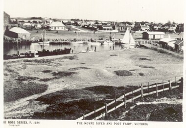
Postcard, The Rose Series / The Rose Stereographs, The Moyne River and Port Fairy, Victoria
River scene of the wharf and the buildings lining the street behind. Black and white photograph taken from Battery Hill looking across Moyne river at Merrijig Inn, Customs House and Courthouse The Rose Series P.1142 copyright- The Moyne River and Port Fairy Victoriastreet, town, moyne, river, couta boat, courthouse, merrijig -
 Vision Australia
Image, Quilt squares
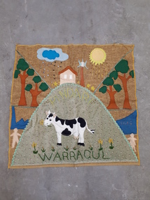
Vision Australia Foundation staff and clients were asked to make a square representing their base, which would be sewn together to represent the multi-faceted nature of the organisation. Unfortunately the patchwork wall hanging incorporating them was not made, however these squares were sent in: Warragul - sun and sunshine, clouds and water, a house on a hill with flowers around it, trees, water, people, a cow on a green hill that has daffodils and Pindari sewed upon it. Ballarat - Kelaston sown in same lettering as Ballarat, large fabric flowers with button centres, a mine head, a person panhandling, a person with a pickaxe. Warrnambool - sun and clouds over a seaside, a boat and whales in the water, a large fir tree and lighthouse. Hamilton - thick plaited stalks with fabric leaves and yellow pom poms as wattle. Digital imagevision australia foundation -
 Port Fairy Historical Society Museum and Archives
Magazine - Newsletter, Richard Patterson, Port Fairy Post, August 2020
An amalgamation of article relating to historical information regarding Port FAiry BelfastDigital newsletternon-fictionAn amalgamation of article relating to historical information regarding Port FAiry Belfastnewsletter, magazine, fairy, boat, stone walls, gas works, david lindsay, lighthouse keeper, john o’brien, stanley hotham chidley, alabama loft house slater, barkly street, barclay street, crossword, whale, john blackstock, w.kelly -
 Bacchus Marsh & District Historical Society
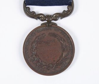
Medal, Royal Humane Society of Australasia Medal Awarded to Thomas Kennedy 3rd August 1891
Thomas Kennedy aged 14 was awarded this medal in 1892 for the bravery he showed in rescuing members of his family from the flooded Werribee River on the 3rd August 1891. The Bacchus Marsh Express newspaper on for 30 July 1892, page 2, reported the awards ceremony with this description, 'Bronze medals of the Royal Humane Society of Australasia were awarded at the Melbourne Town Hall on Monday evening as follows: Thomas Kennedy, of Maddingley, near Bacchus Marsh, aged 14 years, for the risk he incurred in procuring assistance to rescue his father, mother, four brothers and sisters from being drowned during the flood of the Werribee River, on the 3rd August, 1891. He at daybreak swam across a strong current, and procured a boat, then rode a horse attached by a chain to the boat, and was returning thus to the house when he was washed off the horse, and with much difficulty rescued'. Bronze medal with ribbon.Obverse: Virtute Paratum; Reverse: Awarded to Thomas Kennedy 3rd Aug 1891, Royal Humane Society of Australasia, INSTD. A.D. 1874medals, awards, floods 1891 -
 City of Kingston
Photograph - Colour, Paul Tresize, 1998
The name Mordialloc was derived from the name Moody Yallock, which comes from the Bunurong language. The Bunurong Peoples are the Traditional Owners of this area. The name means “high water” or “high creek”. In 1839, colonial authorities declared the mouth of the creek, and an additional 830 odd acres as an Aboriginal Reserve, although this proclamation was never gazetted. The reserved land included part of the Carrum Carrum Swamp which was abundant with wild life and natural resources. Regular encroachments, including land sales which began in 1863, were made on the land until 1878 when the Reserve was declared closed, and the land was opened up to land sales. Market gardening and suburban house lots quickly began to develop, and Mordialloc became a renowned picnic and holiday site. Mordialloc Creek is a popular bay side destination for local and visitors, and is a site for boating, kayaking, fishing and swimming, along with many other activities.Colour photograph of Mordialloc Creek, looking out to the bay. Many small fishing and leisure craft are moored on either side of the banks of the creek. To the right hand side can be seen parklands, while the left hand side has a small inlet in which more small crafts are moored.mordialloc, bunurong, traditional owners, suburbs, boats, fishing, waterways -
 City of Kingston
Photograph - Colour, 1998
The name Mordialloc was derived from the name Moody Yallock, which comes from the Bunurong language. The Bunurong Peoples are the Traditional Owners of this area. The name means “high water” or “high creek”. In 1839, colonial authorities declared the mouth of the creek, and an additional 830 odd acres as an Aboriginal Reserve, although this proclamation was never gazetted. The reserved land included part of the Carrum Carrum Swamp which was abundant with wild life and natural resources. Regular encroachments, including land sales which began in 1863, were made on the land until 1878 when the Reserve was declared closed, and the land was opened up to land sales. Market gardening and suburban house lots quickly began to develop, and Mordialloc became a renowned picnic and holiday site. Mordialloc Creek is a popular bay side destination for local and visitors, and is a site for boating, kayaking, fishing and swimming, along with many other activities.Colour photograph of Mordialloc Creek, looking inland.Small fishing and leisure boats are moored on either side of creek, with a view of the Mordialloc Bridge Hotel in the background.mordialloc, bunurong, traditional owners, suburbs, boats, fishing, waterways, hotel -
City of Kingston
Photograph - Colour, Paul Tresize, 1998
The name Mordialloc was derived from the name Moody Yallock, which comes from the Bunurong language. The Bunurong Peoples are the Traditional Owners of this area. The name means “high water” or “high creek”. In 1839, colonial authorities declared the mouth of the creek, and an additional 830 odd acres as an Aboriginal Reserve, although this proclamation was never gazetted. The reserved land included part of the Carrum Carrum Swamp which was abundant with wild life and natural resources. Regular encroachments, including land sales which began in 1863, were made on the land until 1878 when the Reserve was declared closed, and the land was opened up to land sales. Market gardening and suburban house lots quickly began to develop, and Mordialloc became a renowned picnic and holiday site. Mordialloc Creek is a popular bay side destination for local and visitors, and is a site for boating, kayaking, fishing and swimming, along with many other activities.Colour photograph of Mordialloc Creek, looking inland. Boats are moored on either side of the creek and the Bridge Hotel is visible in the background.mordialloc, bunurong, traditional owners, suburbs, boats, fishing, waterways, hotel -
 City of Kingston
Photograph - Colour, Paul Tresize, 1998
The name Mordialloc was derived from the name Moody Yallock, which comes from the Bunurong language. The Bunurong Peoples are the Traditional Owners of this area. The name means “high water” or “high creek”. In 1839, colonial authorities declared the mouth of the creek, and an additional 830 odd acres as an Aboriginal Reserve, although this proclamation was never gazetted. The reserved land included part of the Carrum Carrum Swamp which was abundant with wild life and natural resources. Regular encroachments, including land sales which began in 1863, were made on the land until 1878 when the Reserve was declared closed, and the land was opened up to land sales. Market gardening and suburban house lots quickly began to develop, and Mordialloc became a renowned picnic and holiday site. Mordialloc Creek is a popular bay side destination for local and visitors, and is a site for boating, kayaking, fishing and swimming, along with many other activities.Colour photograph of Mordialloc Creek with boats moored on both sides of the street and Pompei's boat yard visible on the right hand side of the creek., Main Street and St Brigid's Catholic Church are visible in backgroundmordialloc, bunurong, traditional owners, suburbs, boats, fishing, waterways, hotel, church -
City of Kingston
Photograph - Colour, Paul Tresize, 1998
The name Mordialloc was derived from the name Moody Yallock, which comes from the Bunurong language. The Bunurong Peoples are the Traditional Owners of this area. The name means “high water” or “high creek”. In 1839, colonial authorities declared the mouth of the creek, and an additional 830 odd acres as an Aboriginal Reserve, although this proclamation was never gazetted. The reserved land included part of the Carrum Carrum Swamp which was abundant with wild life and natural resources. Regular encroachments, including land sales which began in 1863, were made on the land until 1878 when the Reserve was declared closed, and the land was opened up to land sales. Market gardening and suburban house lots quickly began to develop, and Mordialloc became a renowned picnic and holiday site. Mordialloc Creek is a popular bay side destination for local and visitors, and is a site for boating, kayaking, fishing and swimming, along with many other activities.Colour photograph of Mordialloc Creek with boats moored on both sides of the street and Pompei's boat yard visible on the right hand side of the creek., Main Street and St Brigid's Catholic Church are visible in background.mordialloc, bunurong, traditional owners, boats, fishing -
City of Kingston
Photograph - Colour, 6 March 1993
Edithvale is a suburb in the City of Kingston. It is located between Aspendale and Chelsea on the Port Phillip Bay and built within remnant areas of the Carrum Carrum swamp. The foreshore precinct comprises a wide sandy beach, with low sand dunes and numerous historic boat sheds. The suburb consists of older style dwellings and former holiday houses, combined with mid-century housing and newer homes. The large blocks are increasingly subdivided and the existing dwellings demolished to accommodate units and townhouses, thus changing the landscape of the area and reducing the tree canopy.The beachside suburb of Edithvale was previously part of the extensive Carrum Carrum Swamp. The area was once a source of fish and eels for the Mayone-Bulluk clan of the Bunurong people. Over time the area was drained and predominantly devoted to dairy farming and holiday houses. The farms were gradually sold and subdivided with a large number of homes built after World War II and in the 1960s. Edithvale is mainly residential with a shopping strip along Nepean Highway but little significant industry was ever established in the area apart from a plaster works and confectionary factory, both now closed.Laminated aerial colour photograph of Edithvale as viewed from Alexandra Avenue in the north to Ella Grove Chelsea/Edithvale in the south. regents Park Aspendale can be seen in the top left. The area is built-up with residential housing and facilities including Edithvale Primary School, numerous churches and the Edithvale Railway station. Large sections depict the remnant Carrum Carrum swamp. Edithvale Common and the former "Duck Inn" (Melbourne Water/Friends of Edithvale Seaford Wetlands) can be seen. Edithvale Recreational reserve, the valodrome and Edithvale Public Golf Course are prominent. The image shows vacant land in the area now known as Aspendale Gardens and the newer residential section of Chelsea Heights is not developed. A bike path has been established to cover the secondary drain. The Golf Links Court residential development located off Hughes Avenue is a large vacant block.Black type on white adhesive label: 6-3-93 Black type on white adhesive label: 25/9211, 6/3/93, 11.20 am Black type on white adhesive label: 9211 Yellow circular adhesive sticker Black pencil: 9211 6-3-93 arrow pointing Nedthvale, carrum carrum swamp, aspendale, chelsea -
 Melbourne Legacy
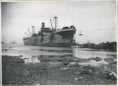
Photograph - Photo, Unloading supplies at Gallipoli
A photo of a boat called River Clyde unloading supplies at a beach presumed to be at the Gallipoli Peninsula. The book 'The Dardanelles' at 01886 has a photo of this boat at Seddul Bahr on page 8. Was with 11 other photos of World War One that had been mounted on board for display at Legacy House at some stage. When they were taken off display they were put in the archive cabinets. The founding legatees all served in World War One so these photos would have been of significant places for them. (see 01888 to 01899)Photos from World War One that would have been significant to the founding legatees.Black and white photo of a boat unloading at Gallipoli.gallipoli, world war one, ship -
 Melbourne Legacy
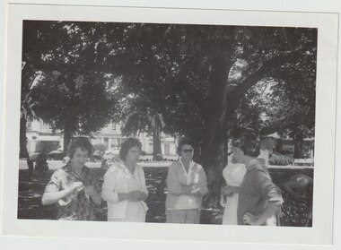
Photograph, Operation Float 1962, 1961
A photo of a group of ladies in Williamstown for Operation Float in 1962. The lady second from left is Mrs Violet Allen who led the summer camps at Blamey House for many years. Operation Float was an opportunity for junior legatees to experience sailing or boating on Port Philip Bay, often organised while they were at a summer camp. Junior Legatees from the country were brought to the city for a two week summer camp, often at Blamey House in Kew, while Junior Legatees from the city were billeted with families in the country. At the time Legatee Bert Davis was CFO, and his daughter Louise was asked to help with the running of the Blamey House camp. Photos donated by Legatee Bert Davis' daughters.A record of outings, holidays and camps provided for Junior Legatees in the 1960s.Black and white photo of five ladies in a park.camps, blamey house, junior legatee outings, operation float -
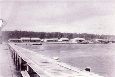
 Lakes Entrance Historical Society
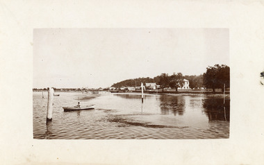
Postcard - Lakes Entrance, 1920c
Also enlarged black and white copy 20 x 25 cmSepia toned postcard probably taken from the Boat Harbour jetty, showing a distant view of the buildings on Esplanade from Maranui Guest House westwards to the Club Hotel. Person in a rowing boat on the calm waters of the lake, known as Cunninghame Arm. Lakes Entrance Victoriaguesthouses, township, waterfront -
 Lakes Entrance Historical Society
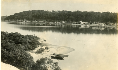
Postcard - Lakes Entrance, 1930c
Two other copies black and white 15.5 x 23 cmBlack and white postcard, taken from across the lake, of the Club Hotel and Stables, Dave Coate's residence, Mitchelson's double story house, Coate Bros Garage (later Crawford's), Robin Hood Inn and Broome's Federal Guest House, launch and houseboat moored in the lake. Lakes Entrance VictoriaLakes Entrance from the South Sidewaterfront, boats and boating, township, retail trade -
 Lakes Entrance Historical Society
Photograph - Street Scene, 1895c
Also copy 13.5 x 20 cmBlack and white photograph of the western view of the Esplanade, also known as Cunninghame, showing early business houses, and residences. Included is Mrs Gleeson's Boarding House, William Barke's store, Heyfield Coffee Palace, butcher shop. Three small jetties, one substantial jetty and two small boats beside lake. Lakes Entrance Victoriatownship, waterfront, retail trade, jetties -
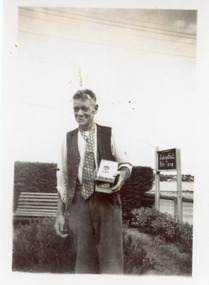 Lakes Entrance Historical Society
Photograph - Beveridge/Kiora House, 1945
Black and white photograph showing Mr R A Andy Beveridge of KiaOra Guesthouse holding the First Prize won in Guesthouse Boat Race in recent regatta, Lakes Entrance Victoriatourism, genealogy, guesthouses -
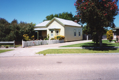 Lakes Entrance Historical Society
Photograph - Historic House, 1999
Built 1900c, cottage was made available for widow and children of Dougal Egan, lost when fishing boat Orme disappeared in 1909. After Mrs Egan married George South, cottage became known as the South House. Later resident Mrs Edith Rawlinson. Cottage restumped, refurbished 2011 / 2012.|Also Two colour photographs various viewsColour photograph of a timber cottage at 26 Church Street, with both hipped and gable iron roof. Triple sided bay window. Sash windows on west side, with window hoods. Western wall is on boundary of allotment. Lakes Entrance Victoriahouses, heritage study -
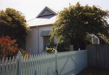 Lakes Entrance Historical Society
Photograph - Historic House, 1999
This house was once the residence of Jules Lake, inaugural member of the Lakes Entrance RSL. A boat builder, he lost a leg on WW1 service.Colour photograph of timber house in Barkes Avenue. Corrugated iron roof, gablet ventilator on ridge. Window has metal window shade. White picket fence. Lakes Entrance Victoriahouses, heritage study -
 Lakes Entrance Historical Society
Photograph, 2008
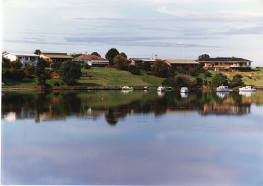
... with a house and jetty with boats moored. Ocean in the background... Channel in the foreground, Hopetoun Channel with a house and jetty ...Date made August 2008Colour photograph showing eastern end of Rigby Island, Snake Island, Reeves Channel in the foreground, Hopetoun Channel with a house and jetty with boats moored. Ocean in the background. Lakes Entrance Victoriawaterways, islands, vegetation -
 Lakes Entrance Historical Society
Photograph - Lakes Entrance, Tambo Shire, 1994 c
... to Ferndale Parade, shows the rear view of six houses, five small...Also second identical copy Jetties Houses Waterways Boats ...Also second identical copyColour photograph of a section of the North Arm adjacent to Ferndale Parade, shows the rear view of six houses, five small boats moored at lake edge. Lakes Entrance Victoriajetties, houses, waterways, boats and boating, township -
 Lakes Entrance Historical Society
Photograph - Box's Creek, 1994 c
... Houses Boats and Boating Colour photograph taken from Box's Creek ...Box's Creek named after Judge Box, early residentColour photograph taken from Box's Creek, showing a modern dwelling on the hillside, a yacht and motor launch at jetty. Metung Victoriawaterways, houses, boats and boating -
 Lakes Entrance Historical Society
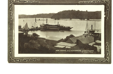
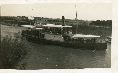
Photograph - New Works Jetty, Cooper, Alexander, 1909c
Also black and white copy with ornamental edge 17 x 26.5 cm, and another copy 19.5 x 30 cmBlack and white photograph showing excursion boats at New Works jetties, people on jetties. S S Gippsland tied to jetty on left and another small steamer. P S Tanjil tied to jetty on right. Roofs of works buildings and twin gable roof of J Carpenter's house on right. Several small row boats and small sail boat. Lakes Entrance VictoriaNew Works from Hummocks Cunninghamships and shipping, jetties, tourism -
 Lakes Entrance Historical Society
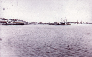
Photograph - New Works, 1890c
Three copies -Sepia photograph showing dunes, houses and Works buildings and boats at the entrance to Gippsland Lakes from ocean - Bass Strait. Photo shows two PWD houses on left and small school building, plus other Works buildings. Flagstaff on dune above houses. Large barge on left in front of houses. Large passenger steamer at New Works wharf with people waiting, has flags and bunting, two masted ketch on right of rock groynes. Lakes Entrance Victoriajetties, boats and boating, settlement, historic site -
 Lakes Entrance Historical Society
Photograph - S.S. Dargo, 1910 c
Also one enlargement black and white 16 x 25.5 cmBlack and white photograph showing steamer Dargo proceeding along the Sale Canal. Shows houses in left background and front of smaller boat on right side, farmland in background, bush on bottom left of photo. Sale Victoriajetties, ships and shipping, waterways -
 Lakes Entrance Historical Society
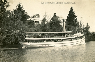
Postcard - S.S. Gippsland, Segerberg and Bulmer, 1909
S S Gippsland was launched at Paynesville 1908. Letter on back mentioning 'Our New Boat'Black and white postcard print showing S S Gippsland in Mitchell river at Bairnsdale, shows three pine trees, large house vegetation on eastern bank, ship leaving Bairnsdale newly painted. Lakes Entrance VictoriaS.S. Gippsland Leaving Bairnsdalevegetation, waterways, ships and shipping, houses -
 Lakes Entrance Historical Society
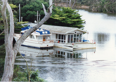
Photograph - Box's Creek, Tambo Shire, 1994
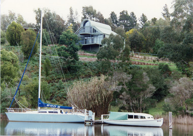
Also second identical copyColour photograph of a holiday house, built over the water at Box's Creek, a motor cruiser moored beside the house. Metung Victoriawaterways, tourism, boats and boating -
 Lakes Entrance Historical Society
Postcard - Bullock Island, Bulmer H D No 15, 1930 c
Black and white double size postcard of Bullock Island. It shows a glimpse of the Princes Highway in foreground, wooden foot bridge to Bullock Island, houses on the hummocks, entrance and Bass Strait in background, boat entering lakes. Lakes Entrance VictoriaPanorama of Lakes Entrance from Princes Highwaywaterways, islands, township, civil engineering -
 Lakes Entrance Historical Society
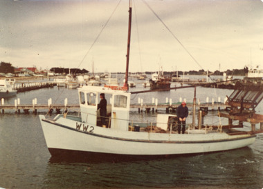
Photograph - Boat Harbour Lakes Entrance, 1980
Colour photograph of an unknown scallop fishing boat entering the boat harbour, one man in wheel house, another man standing on deck. Lakes Entrance Victoriaboats and boating, fishing industry, waterways, jetties -
 Lakes Entrance Historical Society
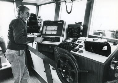
Photograph - Minawie, 1980
Black and white photograph of Dennis Shepherd owner/skipper of the fishing vessel Minawie, shows the well set up wheel house moored at Lakes Entrance Victoriaboats and boating, fishing industry, people