Showing 1059 items matching "boundaries"
-
 Orbost & District Historical Society
photograph, 1893 - 1900
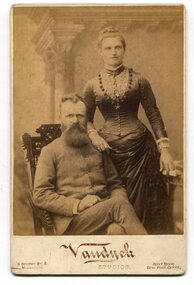
There is no information with this item. In the Bairnsdale Advertiser and Tamboon and Omeo Chronicle on Thursday August 3 1893, there is mention of a letter from Mr Harry Roberts, Marlo Road, "offering to sell the corduroy road to the council for £10, on condition that the council arranges for the exchange of the old road for one on the nothern boundary of his property.-Application to be made to the Lands department for the necessary exchange of roads to carry this proposal into effect. From the secretary for Lands, asking the council to mark the roads required in the M'Colloch on the plan,-Attended" This is likely to be the man in the photograph. This photograph seems to be associated with a very early settler in the Orbost / Marlo area. It is also a pictorial record of dress in the late 19th century.A sepia portrait photograph of a bearded man wearing a high-buttoned coat seated on a chair with a woman standing beside him on the right. The woman is wearing a long gownwith a full skirt, low at the waist. The fitted bodice is tightly buttoned and has a lace panel. Her hair is in a bun. She appears to be wearing a wedding ring. The photograph has been taken inside a studio. The photograph is mounted on card.on back - hand-written - "Mr & Mrs H. Roberts My Best Friend" front under photograph - :Vandyck Studios 3 Bourke St E Melbourne next door Gen Post Office portrait-roberts -
 Stawell Historical Society Inc
Photograph, Warriors Football Club Team 1956
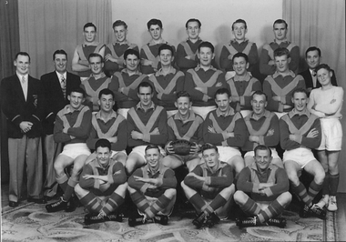
Back Row : G Giles, J Hull, Reeves, F Lever, W Rickard, L Healy 2nd : K Pianta (Sec), L Blake (President), B Larkin, M Stewart, W Hall, R Overall, N Grainger, D Mc Master, J Hatcher (Selector), T Wallace (Boundary) 3rd : P Boag, S Boag, J Larkin, V Chapman, B Chapman, C Smith, B Boag 4th : C Chappell, G Cashin, P Ledger, T Bell.Football team seated and standing with drapes in background.Names on Backsport, football -
 Ringwood and District Historical Society
Photographs, 1979-80 MMBW pipe line project at Hubbard Reserve, North Ringwood � Back-hoe at pit
E560 N6 Dec 1979 A43 The back-hoe works on the beginnings of pit in 39 Burlock Avenue backyard Part of a 43-photo record of the MMBW�s engineering feat in drilling a 12 inch pipe line up to 40 feet deep through rock hardened by volcanic action associated with geological fault that occurs along the line. The work took place from October 1979 to May 1980 on the southern boundary of Hubbard Reserve, North Ringwood. The collection was presented to the Ringwood Historical Research Group by J Clarke on 9th June 1980. -
 Bendigo Historical Society Inc.
Document - ''CITY OF BENDIGO'': A DOCUMENT ''DISTRIBUTED FROM CIVIC OFFICES ON APPLICATION'' 1978
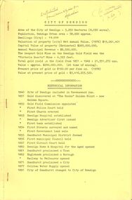
''City of Bendigo'' a document ''Distributed from Civic Offices on application'' 1978. two copies, a. and b. with different handwritten annotations. Contents - Historical Information 1840-1891; ''How Bendigo got its name''; ''Discovery of Gold''; ''Bendigo's Big Year, 1871; a history of Bendigo - in three pages; ''Education in Bendigo''; ''Information on mining in Bendigo''; Bendigo Council incl. elections, officers, revenue, ward boundaries, Mayoral Roll 1856 - 1977; Town Clerk Roll - 1856 - 1977; Town Hall details; 1891 Plebiscite; Coat of Arms details.bendigo, council, bendigo history, coat of arms, town clerk roll, mayoral roll, mining in bendigo, council elections. town hall details. -
 Bendigo Historical Society Inc.
Document - GERMAN HERITAGE SOCIETY COLLECTION: MAPS OF GERMANY
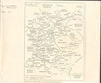
Item 21. Maps of Germany. Germany in 1807 after reconstruction by Napoleon, Germany, Map of Germany States with their Coat of Arms, Thirty Years War Map 21b,Europe in the Time of Henry VIII, Europe in The Time of James I and Charles I, Europe at the End of the 15th Century, Boundaries before 1918 showing Kingdoms, Duchies, provinces, etc., of the Former German Empire (2 copies), Two Grosser Plan Vor Hamburg. Photocopies of Der Rodingsmarkt Hamburg, Kehrwieder Hamburg and Rathhausmarkt und Borse Hamburg. Photocopy of Silesia's Place in History,document, certificate, map of germany, german heritage society collection - maps of germany, theodor w brandt's verlag -
 Kew Historical Society Inc
Archive (series) - Subject File, Barkers Road, 1953
Various PartiesReference, Research, InformationKHS OrderSubject file with multiple items of research relating to the history of Barkers Road, previously Barkers Track (sic) including: 2 copies of ‘Barkers Track: Recollections of the Hawthorn Kew Boundary’ (Typescript, Mervyn Chinner, undated, 4pp), ‘The Boroondara Family Hotel’ (Photocopied typescript, 1987, 10pp), ‘Barkers Road (Gwen McWilliam, 1976), a photocopy of an ADB entry on BARKER, Edward (1816-1885). The file also includes a typed letter to Mrs Dickins from Cr WHS Dickinson (1953) relating to the state of Barkers Road and sundry newspaper clippings/articles.barkers road - kew (vic.), barkers track - kew - hawthornbarkers road - kew (vic.), barkers track - kew - hawthorn -
![Map, Plan of Town Allotments Bacchus Marsh [1891-1897]](/media/collectors/5e461d8021ea67224c82f2a1/items/66acc1c90c778f9f64a3daec/item-media/66acc3990c778f9f64a3e09b/item-fit-380x285.jpg) Bacchus Marsh & District Historical Society
Bacchus Marsh & District Historical SocietyMap, Plan of Town Allotments Bacchus Marsh [1891-1897]
This plan of town allotments in Lerderderg Street and Bennett Street also includes the location of many of the buildings, shops, businesses and houses which were present in the retail and business area of Bacchus Marsh in the 1890s. The precise date of the plan is not known but it must be sometime between 1891 and 1897. The Post Office and the Wesleyan Church are both shown on this plan. Both of these were constructed in 1890. The plan does not show the Baptist Church in Main Street which was constructed in 1898. Hence the date is sometime between 1891 and 1897.This plan of Bacchus Marsh is one of the most detailed visual representations of the location of shops, businesses and houses in the central part of Bacchus Marsh. It provides very precise locations of most of the shops and houses in the town in the 1890s. A single page paper plan showing allotments of land fronting Lerderderg and Bennett Street. Buildings, businesses and houses along most of the streets are identified by hand written annotations. Streets identified on plan: Lerderderg Street - Bennett Street - Main Street - Gell Street - Young Street - Graham Street. Physical boundaries of the map are: North border - Lerderderg Street - South border - Main Street - West border Gell Street - East border - Young Street. The plan is pasted into a bound volume containing 76 maps or plans in total. bacchus marsh victoria maps, shops bacchus marsh -
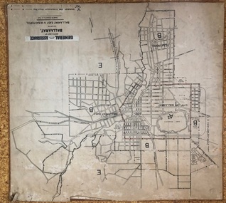 Ballarat Tramway Museum
Map, General Accident Fire and Life Assurance, "Sketch Map of Ballaarat including Ballaarat East and Sebastopol", c1940
Yields information about Ballarat c1940 and how the area was rate for insurance purposes.Map - paper mounted onto a heavy card backing titled "Sketch Map of Ballaarat including Ballaarat East and Sebastopol" with a printed label "General Accident Fire and Life Assurance" pasted to the top of the title. Drawn at 30chains to the inch. Map shows the boundaries between the carious insurance classifications in the district, which relates partly to the local government areas at the time. Shows the Yarrowee, Gong Gong Creeks, rail lines, stations, Black Hill and some other features. Includes the Explosives factory area. Does not show the tram lines.trams, tramways, ballarat, maps, insurance, sebastopol -
Surrey Hills Historical Society Collection
Photograph - Surrey College staff and boarders, 1899, 1899
Surrey College was opened in early 1892 by Rev. Dr Frederick Darling who had been the first minister of the Presbyterian Church in Canterbury Road. He resigned this position to open the school which operated until 1908 with additional premises at 12 Vincent Street. The school had 40 boarders as well as day boys. Courses included algebra, euclid, history, typewriting, shorthand and drill. In the 1930s, Nethercourt Private Hospital took over the site. Later it became St Jude's Hospital. land in front of the building was subdivided off in the 1970s. The building is still extant as a private dwelling with York Street, Surrey Hills as the address. This is one of 3 photos donated by Susan Hobbs, whose grandfather Rev. George Edward Downton is thought to have been a student at the college. George E. Downton was born in Avoca in 1885. He was later a missionary in New Guinea and Secretary to the Australian Board of Missions in Adelaide. He died in 1926 or 1927. Sepia photo of 26 men and boys and one female against a background of a two-storey brick building. This is the rear of the Surrey College. There are 4 additional figures in the background and an additional house can be seen beyond the property boundary. Many of the boys wear or hold caps or boaters. The 2 men in the back row on the right are wearing academic gowns and mortar boards. The gentleman with the beard on the end is Rev. Frederick Darling, the Principal of the college. Sepia photo on cream mount board. Note that the photo is detached from the mount, so the photo is numbered SHP2025.15.1 and the mount as SHP2025.15.2.Front: "Surrey College - Surrey Hills / Principal: Rev. Fredk. A. DARLING, Melb. Univ./STAFF AND BOARDERS, 1899." Back: "York Street, Surrey Hills" in grey lead pencil; possibly Susan John's hand. Back, bottom LH corner: "L. Johnstone" Back, top RH corner: "5621" - this was the registration number used by box Hill historical society Middle back: Purple stamp - "Tennent/Photographer / 110 Johnstone Street / Collingwood" schools, 1899, surrey hills, surrey college, rev frederick a darling, george edward downton, susan hobbs, union road, nethercourt hospital, st jude's hospital, 219-223 union road, 1890-1899, york street -
 Bendigo Historical Society Inc.
Map - HUSTLER'S REEF & HUSTLER'S REEF NO 1 MINES - PLAN OF THE HUSTLER'S REEF & HUSTLER'S REEF NO 1 MINES
Plan of the Hustler's Reef & Hustler's Reef No 1 Mines on the Hustler's Line of Reefs Bulletin No 33, Plate No XV. Plan shows the two mines with depth of levels, geological features and levels in relation to the shaft. Geological Survey of Victoria emblem and signed by H A Whitelaw, Underground Survey Office Bendigo, September 1913. Note - The Lease Boundaries shown on this plan are only in their approximate relative positions to Nos 13, Intermediate and 14 Levels of the Hustler's Reef No 1 workings, and Nos 15, 16 and 17 Levels of the Hustler's Reef workings.mining, parish map, hustler's reef & hustler's reef no 1 mines, geological survey of victoria, underground survey office bendigo, h a whitelaw, hustler's line of reefs -
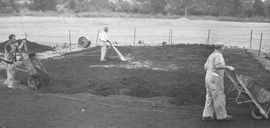 Ringwood and District Historical Society
Photograph, Laying Turf Wicket at Jubilee Park, Ringwood. 1956 with accompanying Newspaper article
Newspaper article reads as follows: "Ringwood's turf wicket - Ringwood's rival to the M.C.G.- The turf wicket being put down at Jubilee Park is coming along nicely now, Merri Creek soil is being put on, and will shortly be followed by the sowing of the grass. Batsmen will not the long drive to the boundary - the oval will actually be bigger than M.C.G." Article "Mail 8/3/56". Stamped on back of photograph, "John Gallagher, Photography". -
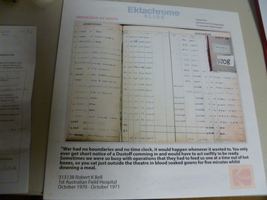 National Vietnam Veterans Museum (NVVM)
Film, Admission and Discharge Book
Coloured image taken from Ektochrome slide by 313138 Robert K Bell. Image of admissions and discharge book dated 19-10-68 - 26-10-68War has no boundaries and no time clock, it would happen whenever it wanted to. You only ever got short notice of a Dustoff comming in and would have to act swiftly to be ready. sometimes we were so busy with operations that they had to feed us one at a time and out of hot boxes, so you sat just outside the theatre in blood soaked gowns for five minutes whilst downing a meal.ektachrome slide, photograph, 1st australian field hospital -
 Kiewa Valley Historical Society
Newspaper Article - Thomas Briggs, 5th March 1988
Thomas Briggs was a pioneer of the Tawonga District. He worked on his parent's farm, selling goods, droving pigs and travelling to Yackandandah and Bright. He worked with pick and shovel on the Tawonga to Bright Road in 1902. He took up 320 acres of wild forest in Tawonga at 10 cents per acre per year for 20 years. He built a slab and shingle hut and a boundary fence. In 1886 he married Annie Maria Platt parenting 5 sons and 2 daughters until Annie died in 1953, aged 86 years.Thomas Briggs was a pioneer living in the Kiewa Valley with his parents and then with wife and family. This article is a history of his life from 1862 until 1887. See KVHS 0850 for information on the dray used to make the Tawonga Gap road - owned by John Briggs.Newspaper article Page 34 Border Morning Mail, Saturday, March 5, 1988 - Thomas Briggs Born 3rd Nov. 1862 who lived with his family at Upper Gundowring. His travels in the area including the Tawonga Gap and its construction in 1902 and his taking up of land in Tawonga in 1880. The article finishes in 1887 when he married Annie Maria Platt. The Thos Briggs story continues next week.thomas briggs; tawonga; kiewa valley; annie platt -
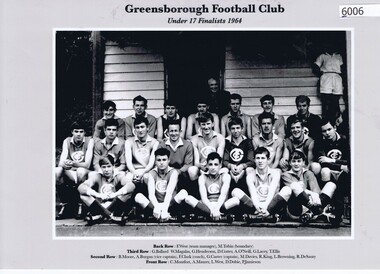 Greensborough Historical Society
Photograph, Greensborough Football Club et al, Greensborough Football Club. Under 17 Finalists 1964, 1964_
Team photograph, Greensborough Football Club Under 17 Finalists 1964. Caption on photo: Back row: F. West (team manager), M. Tobin (boundary); Third row: G. Ballard, W. Magalas, G. Henderson, D. Cotter, A. O'Neil, G .Lacey, T. Ellis; Second row: B. Moore, A. Burgan (vice capt.), F.Clark (coach), G. Carter (capt.), M. Davies, R. King, L. Browning, R. De Sauty; Front row: C. Montfort, A. Maurer, L. West, D. Dobie, P. Jamieson.This photograph is a record of the team - players and support staff - involved in the Under 17s in the 1964 season.Copy of group photograph of football team, players and support staff. Names in caption. greensborough football club, diamond valley football league -
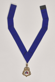 City of Greater Bendigo - Civic Collection
Ceremonial object - Rural City of Marong Medal, Blashki & Sons
The first local government authority for Marong was the Marong Road District (an early form of single-purpose local government), which was proclaimed on 19 August 1860. Its boundary was altered twice in 1862 and on 12 December 1864 it was re designated as a shire. It absorbed Raywood Borough in 1915, and was proclaimed a Rural City in 1990. On 2 December 1994, with the creation of Greater Bendigo City Council, it was abolished by being amalgamated with Bendigo City, Eaglehawk Borough, Huntly Shire, part of McIvor Shire, part of Metcalfe Shire and Strathfieldsaye Shire to form Greater Bendigo City.Rural City of Marong Stirling silver drop, plated in 22 ct gold with enamel centre piece. Medallion hangs from a royal blue neck ribbon. front; RURAL CITY OF MARONG / verso; FORMED AS / MARONG DISTRICT ROADS BOARD / 27th AUGUST 1861 / PROCLAIMED SHIRE OF MARONG / 23rd DECEMBER 1864 / PROCLAIMED RURAL CITY OF MARONG / 1st OCTOBER 1990shire of marong, city of greater bendigo ceremonial item -
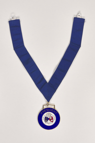 City of Greater Bendigo - Civic Collection
Ceremonial object - Shire of Marong President Medallion, P Blashki & Sons
The first local government authority for Marong was the Marong Road District (an early form of single-purpose local government), which was proclaimed on 19 August 1860. Its boundary was altered twice in 1862 and on 12 December 1864 it was re designated as a shire. It absorbed Raywood Borough in 1915, and was proclaimed a Rural City in 1990. On 2 December 1994, with the creation of Greater Bendigo City Council, it was abolished by being amalgamated with Bendigo City, Eaglehawk Borough, Huntly Shire, part of McIvor Shire, part of Metcalfe Shire and Strathfieldsaye Shire to form Greater Bendigo City.Manufactured by Blashki and Son this circular medal hangs from a royal blue gosgrain ribbon. The medallion has a gold edging with blue enamel outer band. Centre depicts Australia coat of arms and the Shire of Marong coat of arms.PRESIDENT / SHIRE OF MARONG / DIEU ET MON DROIT / INDUSTRIAshire of marong, marong presidents medal, city of greater bendigo ceremonial item -
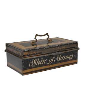 City of Greater Bendigo - Civic Collection
Functional object, Shire of Marong, Unknown
The first local government authority for Marong was the Marong Road District (an early form of single-purpose local government), which was proclaimed on 19 August 1860. Its boundary was altered twice in 1862 and on 12 December 1864 it was re designated as a shire. It absorbed Raywood Borough in 1915, and was proclaimed a Rural City in 1990. On 2 December 1994, with the creation of Greater Bendigo City Council, it was abolished by being amalgamated with Bendigo City, Eaglehawk Borough, Huntly Shire, part of McIvor Shire, part of Metcalfe Shire and Strathfieldsaye Shire to form Greater Bendigo City.Painted metal tin with handle on top. Currently locked closed.Shire of Marongshire of marong -
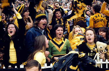 Merri-bek City Council
C-type print, Rennie Ellis, Richmond Fans, Grand Final, MCG 1974, 1974
Rennie Ellis (1940–2003) was as a pivotal figure in Australian visual culture. He was both a documentary photographer and a prominent presence in advertising, television and photography. Ellis was known for his candid documentary images of contemporary Australian life. His photographs of social events, such as music festivals, fashion parades or nightclubs are iconic, but his practice also encompassed the grittier side of life. In his AFL series, Ellis skilfully portrays the nation’s passion for the game, extending his lens beyond the boundary line to showcase the spirited fans alongside the on-field action. -
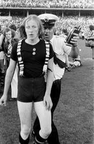 Merri-bek City Council
Giclee print, Rennie Ellis, Fan escorted by policeman, Jolimont 1974, 1974
Rennie Ellis (1940–2003) was as a pivotal figure in Australian visual culture. He was both a documentary photographer and a prominent presence in advertising, television and photography. Ellis was known for his candid documentary images of contemporary Australian life. His photographs of social events, such as music festivals, fashion parades or nightclubs are iconic, but his practice also encompassed the grittier side of life. In his AFL series, Ellis skilfully portrays the nation’s passion for the game, extending his lens beyond the boundary line to showcase the spirited fans alongside the on-field action. -
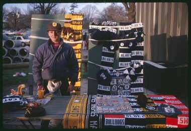 Merri-bek City Council
C-type print, Rennie Ellis, Man standing with table of football fans’ merchandise c.1986, c. 1986
Rennie Ellis (1940–2003) was as a pivotal figure in Australian visual culture. He was both a documentary photographer and a prominent presence in advertising, television and photography. Ellis was known for his candid documentary images of contemporary Australian life. His photographs of social events, such as music festivals, fashion parades or nightclubs are iconic, but his practice also encompassed the grittier side of life. In his AFL series, Ellis skilfully portrays the nation’s passion for the game, extending his lens beyond the boundary line to showcase the spirited fans alongside the on-field action.Donated by the Rennie Ellis Photographic Archive -
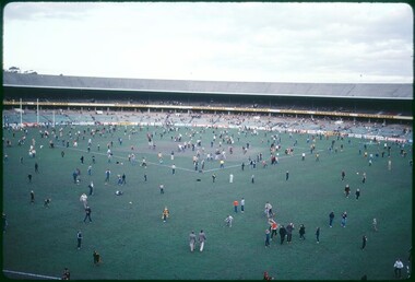 Merri-bek City Council
C-type print, Rennie Ellis, Kids on MCG after VFL game 1980s, c. 1980
Rennie Ellis (1940–2003) was as a pivotal figure in Australian visual culture. He was both a documentary photographer and a prominent presence in advertising, television and photography. Ellis was known for his candid documentary images of contemporary Australian life. His photographs of social events, such as music festivals, fashion parades or nightclubs are iconic, but his practice also encompassed the grittier side of life. In his AFL series, Ellis skilfully portrays the nation’s passion for the game, extending his lens beyond the boundary line to showcase the spirited fans alongside the on-field action.Donated by the Rennie Ellis Photographic Archive -
 Merri-bek City Council
C-type print, Rennie Ellis, Richmond teddy mascot in a car 1982, 1982
Rennie Ellis (1940–2003) was as a pivotal figure in Australian visual culture. He was both a documentary photographer and a prominent presence in advertising, television and photography. Ellis was known for his candid documentary images of contemporary Australian life. His photographs of social events, such as music festivals, fashion parades or nightclubs are iconic, but his practice also encompassed the grittier side of life. In his AFL series, Ellis skilfully portrays the nation’s passion for the game, extending his lens beyond the boundary line to showcase the spirited fans alongside the on-field action.Donated by the Rennie Ellis Photographic Archive -
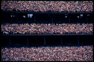 Merri-bek City Council
C-type print, Rennie Ellis, Three tiers of spectators in stands at game, 1972
Rennie Ellis (1940–2003) was as a pivotal figure in Australian visual culture. He was both a documentary photographer and a prominent presence in advertising, television and photography. Ellis was known for his candid documentary images of contemporary Australian life. His photographs of social events, such as music festivals, fashion parades or nightclubs are iconic, but his practice also encompassed the grittier side of life. In his AFL series, Ellis skilfully portrays the nation’s passion for the game, extending his lens beyond the boundary line to showcase the spirited fans alongside the on-field action.Donated by the Rennie Ellis Photographic Archive -
 Merri-bek City Council
C-type print, Rennie Ellis, Carlton Supporter, VFL Grand Final 1982, 1982
Rennie Ellis (1940–2003) was as a pivotal figure in Australian visual culture. He was both a documentary photographer and a prominent presence in advertising, television and photography. Ellis was known for his candid documentary images of contemporary Australian life. His photographs of social events, such as music festivals, fashion parades or nightclubs are iconic, but his practice also encompassed the grittier side of life. In his AFL series, Ellis skilfully portrays the nation’s passion for the game, extending his lens beyond the boundary line to showcase the spirited fans alongside the on-field action.Donated by the Rennie Ellis Photographic Archive -
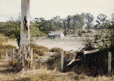 Eltham District Historical Society Inc
Colour Print, David Taylor, Falkiner's Cottage, Ely Street, Eltham, c.1976
Viewed from the western boundary at the rear of Eltham High School looking southwest across part of what would be become the Cronus Court housing development. Aerial photos for 1976 reflect the undeveloped landscape as viewed. By 1981 the estate was well established with all houses built. Falkiner Cottage, also known as Maynard's Cottage. Falkiner was the original owner and Maynard the last owner. The cottage was located on the north side of Ely Street where present day #19 is situated. The cottage ran in a north-south orientation with an easterly aspect down the hill.david taylor collection, eltham, eltham high school, cronus court, ely street, falkiner cottage -
 Ringwood and District Historical Society
Photographs, 1979-80 MMBW pipe line project at Hubbard Reserve, North Ringwood � Boring mole pit
E560 N5 Dec 1979 A43 Boring mole pit near big box tree in 39 Burlock Avenue backyard Part of a 43-photo record of the MMBW�s engineering feat in drilling a 12 inch pipe line up to 40 feet deep through rock hardened by volcanic action associated with geological fault that occurs along the line. The work took place from October 1979 to May 1980 on the southern boundary of Hubbard Reserve, North Ringwood. The collection was presented to the Ringwood Historical Research Group by J Clarke on 9th June 1980. -
 Ringwood and District Historical Society
Photographs, 1979-80 MMBW pipe line project at Hubbard Reserve, North Ringwood � Cover of mole pit
E560 N24 Jan 1980 A43 Cover of mole pit near big box tree in 39 Burlock Avenue backyard Part of a 43-photo record of the MMBW�s engineering feat in drilling a 12 inch pipe line up to 40 feet deep through rock hardened by volcanic action associated with geological fault that occurs along the line. The work took place from October 1979 to May 1980 on the southern boundary of Hubbard Reserve, North Ringwood. The collection was presented to the Ringwood Historical Research Group by J Clarke on 9th June 1980. -
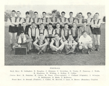 Federation University Historical Collection
Photograph - Football, Ballarat School of Mines Football Team, 1956, 1956
Ballarat School of Mines Football Team. Back row left to right: B. Gallagher, N. Brogden. J. Simpson, J. McArthur, D. Vendy, F. Pomeroy, J. Wolfe. Barry Singleton, W. Widdop, J. McKay, P. Collier. Centre row left to right: B. Dunstan, R. Cutter, B. Tozer (Vice-captain), J. Clelland (captain), I. Schanke, B. Bellingham, N. Hails, P. Robinson. Front row left to right: D. Overall (Trainer), John Collier, B. Bowtell, J. Lane, D. Brown (Boundary Umpire)b. gallagher, n. brogden. j. simpson, j. mcarthur, d. vendy. f. pomeroy, w. widdop, j. mckay, p. collier, b. dunstan, r. cutter, b. tozer (vice-captain), j. clelland (captain), i. schanke, b. bellingham, n. hails, p. robinson, john collier, b. bowtell, j. lane, d. overall, d. brown, ballarat school of mines, ballarat school of mines football team, australian rules football, j. wolfe, barry singleton, b. tozer -
 Flagstaff Hill Maritime Museum and Village
Map - Survey Map, F.F. McGovern, Yangery - County of Villiers, 1884
A surveyor was employed to measure the land designated as Yangery, County of Villiers, in the Borough of Warrnambool. The area on the map is similar to the earlier Farnham Survey undertaken by William Rutledge in the 1850's. Warrnambool was a Borough between 1863-1883. Coutours, waterways, sea and other significant points are shown. The distances are accurately measured. This survey map was used for planning future land sales, recreation areas and roads. WILLIAM RUTLEDGE (1806-1876) William Rutledge surveyed the land known as Farnham in southwest Victoria in 1843. His tenants made him a profitable business from working the land there. In 1863 Rutledge moved from nearby Port Fairy to Farnham and became very successful in breeding sheep, which he imported from J.R. Kirkham of Lincolnshire, England. He also bred horses on his land. The survey map of Yangery is important for its connection with renowned surveyor William Rutledge. The map shows the growth of landholders in the district when compared to the original Rutledge survey of the 1850's.Survey map of Yangery, titled "Yangery - County of Villiers". Printed on white paper, mounted on brown paper. c. 1863-1876. Comments printed on the Map include; Special Survey by William Rutledge, Photo-lithographed at the Department of Lands and Survey, Melbourne by W.J. Burson, Price 1/- [one shilling]. Scale is in Chains. Map has boundaries of Koroit Borough, Meerai, Purnim, Wangoom, Borough of Warrnambool, Mentions the Proposal of Tower HIll for Public Recreation. The map names the owners of the land at that time. Hand written pencil marks and figures and "Sauls fence" drawn on map. Hand written pencil markes and figures and "Sauls fence" drawn onto map. "For Department Use only". "Scale: 8 chains to 1 inch" flagstaff hill, warrnambool, shipwrecked-coast, flagstaff-hill, flagstaff-hill-maritime-museum, maritime-museum, shipwreck-coast, flagstaff-hill-maritime-village, county of villiers map, yangery district, w.j. burson, borough of warrnambool, koroit, purnim, meerai, wangoom, proposal of tower hill for public recreation, special survey by william rutledge, william rutledge, farnham, lincolnshire sheep, clydesdale -
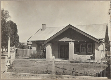 Bendigo Historical Society Inc.
Photograph - T C WATTS & S0N COLLECTION: RUSSELL AND OLINDA STREETS, BENDIGO, 1930
In 1931 electoral rolls, Eric Robert Kevil (1901- 23/5/1980) and his wife lived at 129 Russell St. He had married Edna May Cornish in 1921. By 1943 they had both moved to 77 Valley Pde., Camberwell.Black and white photograph mounted on rectangular brown board. House, pale weatherboard with rough cast above. Corrugated iron roof, one chimney, shingles in gable over verandah, diamond leadlights, bow window L.H., recessed front door rough east surround and pillars to verandah, concave top to verandah wall. Paling side and rear woven wire front and near boundary, lintel over front gate, letterbox. Written on back of photoboard ' Mr. Kevill's Russell and Olinda St., built to order £850 sold, 15.6.34' Date Stamp on back '11 April 1930'Frank A. Jeffree, Bendigorussell street, e.r. kevil, russell street bendigo, t.c. watts and son