Showing 734 items matching "building blocks"
-
 Surrey Hills Historical Society Collection
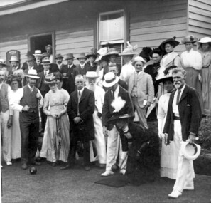
Photograph, Surrey Hills Bowling Club opening in 1912, 1912
James Albon, far right, built a bowling green at his home on the corner of Mont Albert Road and Wilson Street (later occupied by the convent). This green was so popular with his friends that he organised the formation of a bowling club at the corner of Montrose and Wilson Streets. Mr John Kendrick Blogg, wearing the white hat, is standing in the doorway. Earliest club records date from 1916. This was the original club-house; it was rebuilt in 1922/23 using interlocking blocks as recommended by Walter Burley-Griffin. This was quite an innovative design at the time. In turn cream brick buildings replaced this building in the 1950s. The Surrey Hills Bowls Club disbanded in 1995. Our original is framed copy donated by the Surrey Hills Bowls Club (with a spare copy and negative). Someone from the club has the original. Thre is also a frames portrait of James Albon the 1st president in the collection. (NB/ Duplicate = 1813; No.1943 is from the Bowling Club). Some information from Mrs Merle Phillips (deceased) a member when the club closed.A black and white photograph of a group of men and women dressed in their finery. The ladies and men are wearing hats and most men in 3 piece suits. One lady is in position to roll a bowl. The women's dresses are all ankle length."SHBC 1912"mont albert road, wilson street, surrey hills, montrose street, surrey hills bowling club, 1912, clothing and dress, mr james albon, mr john kendrick blogg -
 Surrey Hills Historical Society Collection
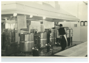
Photograph, W J Vine, timber merchant and ironmonger, c1899
Vines Timber yard was established in 1897 after the timber yard established by Donald Douglas in 1887 was acquired by William James Vine in 1896. Vines Timber yard was managed by William and his son Albert Ernest (Ernie) until the 1950s when there were no vacant blocks of land in Surrey Hills and less requirement for building materials. William Vine is listed in the 1893 directory as living in Albany Crescent. He married Sarah Elizabeth Gunner in 1881. The business was badly affected by a large fire in 1920. Albert Vine (1903-1968) was a Camberwell councillor from 1926-1934. He was also Mayor of Camberwell in 1940/41 and a councillor from 1937-1944. His son Ernest Albert also becoming a Councillor and Mayor of Camberwell. Exterior of building of W J Vine timber merchant and ironmonger in 1899. There are 5 men standing outside. 'Year 1899' in lower LH cornerbusinesses, timber merchant, ironmonger, vine's timber yard, donald douglas, william james vine, ernie vine, albert ernest vine, sarah elizabeth gunner, sarah elizabeth vine -
 Brighton Historical Society
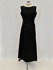
Evening dress and bag, 1950s
This dress and bag belonged to Mrs Edith "Dot" Paroissien (nee Jackson, born 1916), who lived in Brighton with her husband David William Paroissien. The dress was purchased from Croyde, a Melbourne designer who had a small boutique shop in Collins Street near the Block Arcade, and the bag was bought for her in London by David. Dot recalled wearing the dress in the 1950s, in particular to a ball at the Royal Exhibition Buildings for Wesley College. She wore it with suede shoes with a medium heel with straps across the instep and long white kid gloves, and accessorised with a baguette choker and drop earrings.Black silk satin sleeveless full-length evening dress. The attached bodice floats over the top of the under-dress. Asymmetrical opening on bodice which features five large flat self-covered buttons. The black suede bag has chrome fittings and buttery cream coloured satin interior. .1 dress - Label, woven black on white acetate centre back: CROYDE / MELBOURNE .2 - bag - Label, printed, black on cream acetate, interior pocket: Susan / HANDBAGS / LONDON; Label, printed, copper on black metal, interior pocket: MADE IN ITALY / FOR SUSANevening dress, croyde, melbourne fashion, melbourne designers, handbag, royal exhibition building, 1950s, edith violetta paroissien, edith violetta jackson -
 Vision Australia
Photograph - Image, Queensland Industrial Institute for the Blind workshop, May 1970?
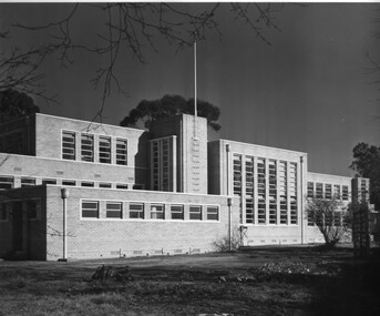
Two images taken of two possibly different buildings. The first appears to be the workshop owned by Queensland Industrial Institute for the Blind, after restoration; and the other, given similar images at State Archives Queensland, a new dormitory/kitchen/laundry block.2 x B/W photographs of a brick double storey buildingqueensland industrial institute for the blind, buildings -
 Vision Australia
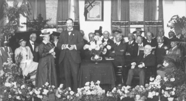
Photograph - Image, Free Lending Library of the Blind building opening, 1919
In 1894 the Victorian Braille Writers Association was established in order to create a braille lending library. Such an endeavor also meant a need of space for storage. At first the library was accommodated in the home of Mrs May Harrison before moving to the home of Mrs Dickinson two years later. Eventually, with the help of donors, a space was rented in the Block Arcade to house the 1300+ volumes it held and the yearly increase produced by its braille transcribers. Fortunately in 1918 the Trustees of the Edward Wilson Estate provided 4000 pounds to pay for a new building in Commercial Road. Despite some misgivings from the RVIB at the time, this building was home to both braille volumes and talking books (albums and cassettes) for many years.1 b/w photograph of people on a stageFree Lending Library for the Blind. Senator G. Fairbairn, on behalf of the Edward Wilson Trust, presenting the key of the building to Miss Aston, a Braille reader, representing the Braille Writer’s Association. 26th April 1919. (Label on mount board)tilly aston, braille and talking book library -
 University of Melbourne, Burnley Campus Archives
Plan, [Plans for Extensions to Student Amenities Building], 1996-2001
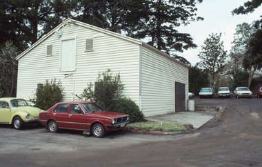
(1) External paving & footing plan - Proposed outdoor eating plan at Student Amenities Block, Victorian College of Agriculture & Horticulture. For - Burnley Student Association (Ross Greer Consultants P/L). Includes design modifications 2001. (2) Proposed outdoor eating area Student Amenities Block, VCAH. Schemes 1-8. (Includes plans for pergola, terrace, etc.) (3) Quotes from landcraft for landscape works around canteen (including ramps.) (4) John Stephens Catering Equipment Pty. Ltd. - Burnley Student Union. Plan View 1:20. Many copies of most documents including amendments.amenities, students, vcah, burnley -
 University of Melbourne, Burnley Campus Archives
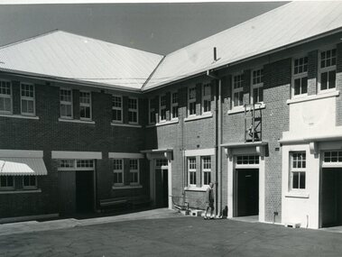
Photograph - Black and white print, Commercial Photographic Co. Pty. Ltd, Administration Building, 1949
Note by T.H. Kneen 20 February 1991, "East facade of building L to R Library over Assembly Hall, change rooms, classroom block, offices for school staff & three branches of Department of Agriculture, Principal's office to extreme right." 2 copies black and white photograph. Taken further to the left of B91.24On reverse, "1949 Commercial Photographic Co. Pty. Ltd. FJ 5266 When ordering further prints please quote K370-6".library, assembly hall, change rooms, classroom block, office, staff, principal, administration building, branches dept of agriculture, main building -
University of Melbourne, Burnley Campus Archives
Photograph - Black and white print, 680/111
... of classroom block." THK administration building swan street magnolia ..."The roads have been constructed - plantings at the base of the building are developing. Note Magnolia grandiflora selected by Mrs. Gibson to ornament the bare wall of classroom block." THKView of Administration Building from Swan Street entrance.administration building, swan street, magnolia, mrs. gibson, e. m. gibson collection -
 Vision Australia
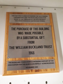
Image, The William Buckland Trust 1968, 1994
The William Buckland Trust (now Foundation) provides support for disadvantaged Victorians through support for four key areas. The growing need for space at the Association for the Blind's offices in Kooyong was constraining the amount of people who could benefit from it's programs. With the assistance of the William Buckland and Hecht Trusts, the adjoining blocks of flats fronting Glenferrie Road were acquired and eventually demolished to make way for the Vision Resource Centre. The support from the Buckland Trust in 1968 was not forgotten however, and this plaque acknowledges the support gained in purchasing the land.Digital image of metal plaques attached to a boardThis historic plaque recognises the outstanding contribution that the Buckland Foundation made to the purchase of the site on which the Vision Resource Centre now stands. The purchase of this building was made possible by a substantial gift from the William Buckland Trust 1968. The Buckland Foundation's continuing support of the Association for the Blind is gratefully acknowledged. November 1994.association for the blind, h & l hecht trust, william buckland trust -
 Federation University Art Collection
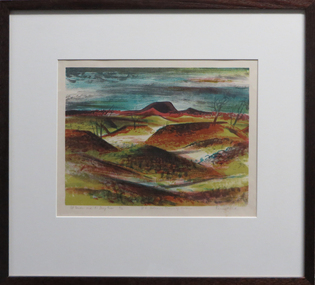
Work on paper - Artwork - Printmaking, Jack, Kenneth, "Mt Porndon and the Stony Rises - No 6 Volcanic Plains of Victoria" by Kenneth Jack, 1962
Kenneth JACK AM MBE RWS, (5 October 1924 – 10 June 2006) Australian watercolour artist Kenneth Jack who specialised in painting the images of an almost forgotten outback life; old mine workings, abandoned ghost towns, decaying farm buildings. He became a professional painter at the age of 39 after giving up his job as senior instructor at the Caulfield Institute of Technology. In 1977 he was elected to The Royal Watercolour Society and in 1982 was awarded the MBE, and the Order of Australia (AM) followed in 1987. Framed three block lino print showing the volcanic plains of Victoria around Stony Rises. It is Number 6 in the Volcanic Plains of Victoria series. Donated through the Australian Gifts Programme by Katherine Littlewood.31/40artwork, artist, kenneth jack, printmaking, volcano, mt porndon, mount porndon, linocuts -
 University of Melbourne, Burnley Campus Archives
Album - Colour slides, Burnley - Miscellaneous Views, 1954-1969
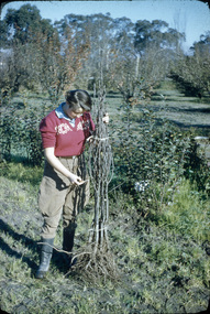
Contributor: T.H. KneenBox of slides, mostly labelled. 1. "School Building (May 1960) No. 1950." 2. "Students 5-2-58 John Richards Helen Page Instructor J.B. Nowell No. 1881." 3. "Orchard-Burnley (1960) No. 1953." 4. "Flower Bed & Lawns No. 1774." 5. "Plant Science Block Jul 69." 6. "Citrus myrtifolia being lifted (1960) No. 1945." 7, 8, "Mar 67." 9. "Dec 66." 10. "Long Border Aug '54 No. 1758." 11. "Border Display & Pond No. 1792." 12. "Rose Pruning Jul 67." 13. "Grampians-MCK Falls 10/65." 14. "Archway- Burnley Gar Yellow Banksia Rose No. 1779." 15. "P.R.L. No. 1684." 16. "Principal's Residence (Spring) Amygdalus pollardii No. 1716." 17. Views of Drive No. 1676." 18. "Field Day '57 Demonstration Burnley No. 1917." 19. "Shrubs & Annuals No. 1772." 20. "Burnley Gardens Flower Beds & Lawns Aut 1957 No. 1742." 21. "Vegetable GardenStudents 5.2.58 John Deverson Dorothy Issell Instructor I.G. McCure." 22. "School Lawn Golden Willow No.1754." 23. "Rose Pruning Demo No.1969 Jul 89." 24. "Field Day '57 Budding Burnley No. 1911." 25. "Field Day 57 Drainage No.1918 Burnley." 26. Rose Pruning Demo T. Komebum? Jul 69." 27. "Rose Pruning Demo Jul 69." 28. "Orchard." 29. "Wilson's Promontory N. P. Tidal River."school building, students, john richards, helen page, j.b. nowell, burnley, flower beds, lawns, administration building, orchard, plants, long border, rose pruning, grampians, principals residence, vegetable gardens, students working outside, lawnmower, john deveson, dorothy issell, golden willow, field day, wilsons promontory -
 University of Melbourne, Burnley Campus Archives
Album - Colour slides, Burnley Views, 1956-1969
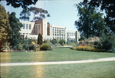
... kneen family sign wintersweet plant science block administration ...Contributor: T.H. KneenBox of 47 slides, some labelled. (1) "Marjorie Hall 1st Year Student June '56 No. 1872." Working with fruit tree stock. (2) "Orchard June 1956 No. 1710." 2 men and a tractor.(3) "Camp 1957." Wilson's Promontory. (4) View of Drive No. 1677." C. 1958 (5) "GenView No. 1771." (6) "Burnley Gardens Entrance 4.4.58 N0. 1672." (7) "Wilson's Promontory Lilly Pilly Gully Nov 1960." (8) Dec '62." (9) "Dec '62." Kneen child. (10) Luffmann Ponds "Aut. 1962." (11) Grevillea Sep 1963. (12) Sep 1963.Reflection of Crack Willow in Luffmann Ponds. (13) Sep 1963. Orchard blossom. (14) View of Administration Building at sunset Aug 1964. (15) Rose 'Heat Wave.' May 1965. (16) Kneen child sitting under a tree May 1966. (17) 'Department of Agriculture Burnley Gardens' sign May 1966. (18) Administration Building May 1966. (19) Plant Science Block May 1966. ((20) Wintersweet August 1966.(Actually appears to be Witch Hazel Hamamelis mollis.) (21) Student on tractor in the Orchard October 1966. (22) Garden view, view of Principal's Residence through blossom trees October 1966. (23) Students walking through the Gardens October 1966. (24) "Leaf Cuttings Rex begonia 2 October 1966. (25) Emily Gibson beds October 1966. (26) Principal's Residence in a garden view October 1966. (27) Garden view looking towards the Principal's Residence and the Shady Garden October 1966. (28) Drive looking towards the Administration Building from the Plant Research Institute. (29) Kneen child (not Burnley?) (30) Unveiling of Burnley Horticultural College plaque commemorating 75 years, 1891-1966 - Eric Littlejohn, ?, T.H. Kneen. Includes key to Pavilion 1969. (31) "Rose Pruning Demo - Canteen." July 1969. (32, 33) "Rose Pruning Demo 1969." July 1969. (34) "Plant Science Block & College." July 1969. (35) Plant Science Block 6/69." July 1969. (36) "Burnley Gardens 6/69." looking towards Dairy and Yarra Boulevard (37) "Pond No. 1717." (38) "Pond 1748." Kneen children playing by the Luffmann Ponds, Oak tree behind.. (39) Ginkgo leaves June 1967. (42) ? (43) Erithyna caffra in flower (removed 2016) December 1966. ((44) Administration Building and Nursery from PRI." (45) Pelargoniums. (46) Azalea mollis (47) Pelargonium foreground, geranium background.marjorie hall, students, fruit trees, orchard, tractor, wilson's promontory, burnley gardens, entrance, drive, garden view, luffmann ponds, grevillea, rose, kneen family, sign, wintersweet, plant science block, administration building, students working outside, principals residence, plaque, rose pruning demonstrations, ginkgo, pelargoniums, erythryna -
 University of Melbourne, Burnley Campus Archives
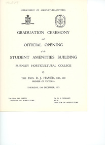
Programme - Graduation Ceremony Program, Department of Agriculture, Victoria, Graduation Ceremony & Official Opening of the Student Amenities Building, 1973
The Student Amenities Building was officially opened by the Hon. R. J. Hamer, Premier of Victoria. Also present: Ian Smith, Minister for Agriculture and Dr. D. S. Wishart, Director of Agriculture.graduation ceremony, student amenities building, sketch, burnley horticultural college, the hon. r. j. hamer, ian smith premier of victoria, minister for agriculture, dr. d. s. wishart, director of agriculture, graduation ceremony programme -
 University of Melbourne, Burnley Campus Archives
Photograph - 35mm Colour slides, Miscellaneous, 1969-1987
... . "Nursery Block from College Building" (roof) Mar 77. 13-14 slides... garden views garden beds administration building nursery block ...1. "Hockey 1969 R. Hamley Foreground" Jul 69. 2-5. "Clearing Tech Block Site" Jul 69. 6. Garden view Dec 75. 7. "Nursery Block from College Building" (roof) Mar 77. 13-14 slides garden beds in front of Administration Building Sep 81. Garden view Feb 87.23. "Wide World of Gardening' display Mar 86. 17-19 View towards Plant Research Institute. 15-16, 21-22 Construction New Library. hockey, 1969, r. hamley, tech block site, garden views, garden beds, administration building, nursery block, wide world of gardening display, construction new library, plant research institute -
 University of Melbourne, Burnley Campus Archives
Album - 35mm Colour slides, Buildings on Burnley Campus, 1985
21 slides of buildings on the Burnley Campus including: 1, 3, Dairy, 6. Principal's garage, Greenhouses, 8. Media Bins, 2, 4, 5.Engineering. Stamped "9 Sep 1985" Aug 85 and 22 Library Sep 85. 11-14. Landscape Shed. 24. Orchard. Some not identified.burnley campus, dairy, tech block, principal's garage, greenhouses, media bins, arboriculture, engineering, library, landscape shed, machinery shed, orchard -
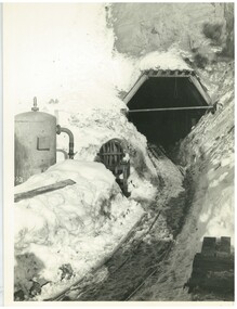
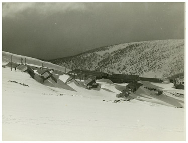
 Falls Creek Historical Society
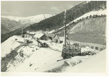
Photograph - No. 1 Headrace Tunnel, Kiewa Hydroelectric Scheme Workshops, 1952
MEYER COLLECTION - FALLS CREEK PHOTOS In 1947 a determined group of like-minded State Electricity Commission (SEC) staff including Ray Meyer, the chief surveyor of the Kiewa Hydro-Electric Scheme, had a common interest that revolved around the skiing potential of the snow-covered high plains which included what is now the resort of Falls Creek. The six SEC employees, Toni St Elmo, Ray Meyer, Jack Minogue, Lloyd Dunn, Adrian Ruffenacht and Dave Gibson (together with their families) banded together to secretly build a 'hut' that was the first ski lodge at Falls Creek. Using a road built in 1930s to gain access to Falls Creek, their hut project was carried out in secret as efforts by other skiers were blocked by H.H.C. Williams – the engineer in charge of the Hydro Scheme. In 1946 Ray Meyer made a trip to the Lands Office in Melbourne. He came away with a 99-year lease on three acres that was ideally suited for a hut designed by Lloyd Dunn. Adrian Ruffenacht (Design Engineer for the KHS) had suggested where the group should build because of easy access to a spring for water. Much of the building material required was scavenged from derelict huts on the high plains. Due to the need for secrecy, the determined group worked on the hut in the evenings and weekends to avoid detection. During the building period the group had met at Echidna Rock (now known as Eagle Rock) where Skippy St Elmo announced, "This is my favourite ‘Skyline’.” And so the first lodge in the area at Falls Creek Ski Resort came into existence. With the development of the International Poma in the 1970s, the Skyline Lodge, which was sited between the ski-lift’s pole one and pole two, was demolished. However, the legacy of Ray Meyer, Toni St Elmo, Jack Minogue, Lloyd Dunn, Adrian Ruffenacht and Dave Gibson and Skyline lives on in the vibrant atmosphere of Falls Creek Resort. The MEYER COLLECTION documents developments on the Kiewa Hydro Scheme and their life at Falls Creek from the mid 1930s to 1950s.This image is significant because it documents development of the Kiewa Hydroelectric Scheme.A black and white image of the No 1 Headrace Tunnel, Kiewa Hydroelectric Scheme showing workshops and the McKay Aditkiewa hydroelectric scheme, ray meyer -
 Falls Creek Historical Society
Photograph - No. 1 Headrace Tunnel, Kiewa Hydroelectric Scheme, 1952
MEYER COLLECTION - FALLS CREEK PHOTOS In 1947 a determined group of like-minded State Electricity Commission (SEC) staff including Ray Meyer, the chief surveyor of the Kiewa Hydro-Electric Scheme, had a common interest that revolved around the skiing potential of the snow-covered high plains which included what is now the resort of Falls Creek. The six SEC employees, Toni St Elmo, Ray Meyer, Jack Minogue, Lloyd Dunn, Adrian Ruffenacht and Dave Gibson (together with their families) banded together to secretly build a 'hut' that was the first ski lodge at Falls Creek. Using a road built in 1930s to gain access to Falls Creek, their hut project was carried out in secret as efforts by other skiers were blocked by H.H.C. Williams – the engineer in charge of the Hydro Scheme. In 1946 Ray Meyer made a trip to the Lands Office in Melbourne. He came away with a 99-year lease on three acres that was ideally suited for a hut designed by Lloyd Dunn. Adrian Ruffenacht (Design Engineer for the KHS) had suggested where the group should build because of easy access to a spring for water. Much of the building material required was scavenged from derelict huts on the high plains. Due to the need for secrecy, the determined group worked on the hut in the evenings and weekends to avoid detection. During the building period the group had met at Echidna Rock (now known as Eagle Rock) where Skippy St Elmo announced, "This is my favourite ‘Skyline’.” And so the first lodge in the area at Falls Creek Ski Resort came into existence. With the development of the International Poma in the 1970s, the Skyline Lodge, which was sited between the ski-lift’s pole one and pole two, was demolished. However, the legacy of Ray Meyer, Toni St Elmo, Jack Minogue, Lloyd Dunn, Adrian Ruffenacht and Dave Gibson and Skyline lives on in the vibrant atmosphere of Falls Creek Resort. The MEYER COLLECTION documents developments on the Kiewa Hydro Scheme and their life at Falls Creek from the mid 1930s to 1950s.This image is significant because it documents development of the Kiewa Hydroelectric Scheme.Two black and white images of the McKay Adit, Kiewa Hydroelectric Scheme' kiewa hydroelectric scheme, ray meyer -
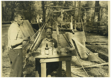 Falls Creek Historical Society
Photograph - Big River Survey Camp, c1949
MEYER COLLECTION - FALLS CREEK PHOTOS In 1947 a determined group of like-minded State Electricity Commission (SEC) staff including Ray Meyer, the chief surveyor of the Kiewa Hydro-Electric Scheme, had a common interest that revolved around the skiing potential of the snow-covered high plains which included what is now the resort of Falls Creek. The six SEC employees, Toni St Elmo, Ray Meyer, Jack Minogue, Lloyd Dunn, Adrian Ruffenacht and Dave Gibson (together with their families) banded together to secretly build a 'hut' that was the first ski lodge at Falls Creek. Using a road built in 1930s to gain access to Falls Creek, their hut project was carried out in secret as efforts by other skiers were blocked by H.H.C. Williams – the engineer in charge of the Hydro Scheme. In 1946 Ray Meyer made a trip to the Lands Office in Melbourne. He came away with a 99-year lease on three acres that was ideally suited for a hut designed by Lloyd Dunn. Adrian Ruffenacht (Design Engineer for the KHS) had suggested where the group should build because of easy access to a spring for water. Much of the building material required was scavenged from derelict huts on the high plains. Due to the need for secrecy, the determined group worked on the hut in the evenings and weekends to avoid detection. During the building period the group had met at Echidna Rock (now known as Eagle Rock) where Skippy St Elmo announced, "This is my favourite ‘Skyline’.” And so the first lodge in the area at Falls Creek Ski Resort came into existence. With the development of the International Poma in the 1970s, the Skyline Lodge, which was sited between the ski-lift’s pole one and pole two, was demolished. However, the legacy of Ray Meyer, Toni St Elmo, Jack Minogue, Lloyd Dunn, Adrian Ruffenacht and Dave Gibson and Skyline lives on in the vibrant atmosphere of Falls Creek Resort. The MEYER COLLECTION documents developments on the Kiewa Hydro Scheme and their life at Falls Creek from the mid 1930s to 1960s.This image is significant because it documents development of the Kiewa Hydroelectric Scheme.Two black and white images at the Big River Old Survey Camp.Photo 1 - Breakfast at Big River Left to RIght Ray Meyer, Wal Johnson Photo 2 - Big River Survey Camp at foot of T Spur C 1949, Kiewa RIver Survey Team.kiewa hydroelectric scheme, ray meyer, wal johnson -
 Falls Creek Historical Society
Photograph - Pupils at Bogong School, c1949
MEYER COLLECTION - FALLS CREEK PHOTOS In 1947 a determined group of like-minded State Electricity Commission (SEC) staff including Ray Meyer, the chief surveyor of the Kiewa Hydro-Electric Scheme, had a common interest that revolved around the skiing potential of the snow-covered high plains which included what is now the resort of Falls Creek. The six SEC employees, Toni St Elmo, Ray Meyer, Jack Minogue, Lloyd Dunn, Adrian Ruffenacht and Dave Gibson (together with their families) banded together to secretly build a 'hut' that was the first ski lodge at Falls Creek. Using a road built in 1930s to gain access to Falls Creek, their hut project was carried out in secret as efforts by other skiers were blocked by H.H.C. Williams – the engineer in charge of the Hydro Scheme. In 1946 Ray Meyer made a trip to the Lands Office in Melbourne. He came away with a 99-year lease on three acres that was ideally suited for a hut designed by Lloyd Dunn. Adrian Ruffenacht (Design Engineer for the KHS) had suggested where the group should build because of easy access to a spring for water. Much of the building material required was scavenged from derelict huts on the high plains. Due to the need for secrecy, the determined group worked on the hut in the evenings and weekends to avoid detection. During the building period the group had met at Echidna Rock (now known as Eagle Rock) where Skippy St Elmo announced, "This is my favourite ‘Skyline’.” And so the first lodge in the area at Falls Creek Ski Resort came into existence. With the development of the International Poma in the 1970s, the Skyline Lodge, which was sited between the ski-lift’s pole one and pole two, was demolished. However, the legacy of Ray Meyer, Toni St Elmo, Jack Minogue, Lloyd Dunn, Adrian Ruffenacht and Dave Gibson and Skyline lives on in the vibrant atmosphere of Falls Creek Resort. The MEYER COLLECTION documents developments on the Kiewa Hydro Scheme and their life at Falls Creek from the mid 1930s to 1960s.This image is significant because it documents life in the early years of development of the Bogong High Plains, Victoria.A black and white image of pupils and teacher at Bogong School. Teacher Beverley Hayward. This photo is a newspaper photo published in a Melbourne newspaper at the time (c1949). John Meyer is child third to the right of the teacher.bogong primary school, john meyer -
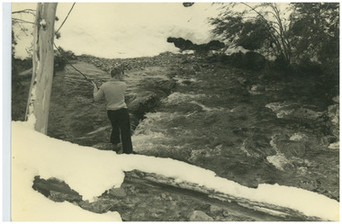 Falls Creek Historical Society
Photograph - Ray Meyer at Blair's Hut
MEYER COLLECTION - FALLS CREEK PHOTOS In 1947 a determined group of like-minded State Electricity Commission (SEC) staff including Ray Meyer, the chief surveyor of the Kiewa Hydro-Electric Scheme, had a common interest that revolved around the skiing potential of the snow-covered high plains which included what is now the resort of Falls Creek. The six SEC employees, Toni St Elmo, Ray Meyer, Jack Minogue, Lloyd Dunn, Adrian Ruffenacht and Dave Gibson (together with their families) banded together to secretly build a 'hut' that was the first ski lodge at Falls Creek. Using a road built in 1930s to gain access to Falls Creek, their hut project was carried out in secret as efforts by other skiers were blocked by H.H.C. Williams – the engineer in charge of the Hydro Scheme. In 1946 Ray Meyer made a trip to the Lands Office in Melbourne. He came away with a 99-year lease on three acres that was ideally suited for a hut designed by Lloyd Dunn. Adrian Ruffenacht (Design Engineer for the KHS) had suggested where the group should build because of easy access to a spring for water. Much of the building material required was scavenged from derelict huts on the high plains. Due to the need for secrecy, the determined group worked on the hut in the evenings and weekends to avoid detection. During the building period the group had met at Echidna Rock (now known as Eagle Rock) where Skippy St Elmo announced, "This is my favourite ‘Skyline’.” And so the first lodge in the area at Falls Creek Ski Resort came into existence. With the development of the International Poma in the 1970s, the Skyline Lodge, which was sited between the ski-lift’s pole one and pole two, was demolished. However, the legacy of Ray Meyer, Toni St Elmo, Jack Minogue, Lloyd Dunn, Adrian Ruffenacht and Dave Gibson and Skyline lives on in the vibrant atmosphere of Falls Creek Resort. The MEYER COLLECTION documents developments on the Kiewa Hydro Scheme and their life at Falls Creek from the mid 1930s to 1960s.This image is significant because it documents the activities of a prominent family in Falls Creek, VictoriaA photo of Ray Meyer at the Kiewa River near Blairs Hut. The original hut, built by cattlemen Frank and Tim Blair in 1923-24, was burnt down around 193o. It was rebuilt by Frank and his son in 1932. It is constructed of Alpine Ash.ray meyer, blairs hut, falls creek, victorian snowfields -
 Falls Creek Historical Society
Photograph - Rocky Valley Camp
MEYER COLLECTION - FALLS CREEK PHOTOS In 1947 a determined group of like-minded State Electricity Commission (SEC) staff including Ray Meyer, the chief surveyor of the Kiewa Hydro-Electric Scheme, had a common interest that revolved around the skiing potential of the snow-covered high plains which included what is now the resort of Falls Creek. The six SEC employees, Toni St Elmo, Ray Meyer, Jack Minogue, Lloyd Dunn, Adrian Ruffenacht and Dave Gibson (together with their families) banded together to secretly build a 'hut' that was the first ski lodge at Falls Creek. Using a road built in 1930s to gain access to Falls Creek, their hut project was carried out in secret as efforts by other skiers were blocked by H.H.C. Williams – the engineer in charge of the Hydro Scheme. In 1946 Ray Meyer made a trip to the Lands Office in Melbourne. He came away with a 99-year lease on three acres that was ideally suited for a hut designed by Lloyd Dunn. Adrian Ruffenacht (Design Engineer for the KHS) had suggested where the group should build because of easy access to a spring for water. Much of the building material required was scavenged from derelict huts on the high plains. Due to the need for secrecy, the determined group worked on the hut in the evenings and weekends to avoid detection. During the building period the group had met at Echidna Rock (now known as Eagle Rock) where Skippy St Elmo announced, "This is my favourite ‘Skyline’.” And so the first lodge in the area at Falls Creek Ski Resort came into existence. With the development of the International Poma in the 1970s, the Skyline Lodge, which was sited between the ski-lift’s pole one and pole two, was demolished. However, the legacy of Ray Meyer, Toni St Elmo, Jack Minogue, Lloyd Dunn, Adrian Ruffenacht and Dave Gibson and Skyline lives on in the vibrant atmosphere of Falls Creek Resort. The MEYER COLLECTION documents developments on the Kiewa Hydro Scheme and their life at Falls Creek from the mid 1930s to 1960s.This image is significant because it documents the development of the Kiewa Hydroelectric Scheme.A black and white image of Rocky Valley Camp. Work began on the Rocky Valley Dam site in early 1947 and continued until May. It resumed in October after the winter and a camp for the accommodation of workmen was commenced at this time. Work continued in 1948 with the establishment of work facilities, including the erection of two large excavators. The Rocky Valley Dam was completed in 1959.ray meyer, blairs hut, falls creek, victorian snowfields -
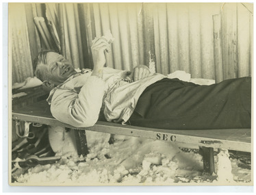 Falls Creek Historical Society
Photograph - Ray Meyer, 1951
MEYER COLLECTION - FALLS CREEK PHOTOS In 1947 a determined group of like-minded State Electricity Commission (SEC) staff including Ray Meyer, the chief surveyor of the Kiewa Hydro-Electric Scheme, had a common interest that revolved around the skiing potential of the snow-covered high plains which included what is now the resort of Falls Creek. The six SEC employees, Toni St Elmo, Ray Meyer, Jack Minogue, Lloyd Dunn, Adrian Ruffenacht and Dave Gibson (together with their families) banded together to secretly build a 'hut' that was the first ski lodge at Falls Creek. Using a road built in 1930s to gain access to Falls Creek, their hut project was carried out in secret as efforts by other skiers were blocked by H.H.C. Williams – the engineer in charge of the Hydro Scheme. In 1946 Ray Meyer made a trip to the Lands Office in Melbourne. He came away with a 99-year lease on three acres that was ideally suited for a hut designed by Lloyd Dunn. Adrian Ruffenacht (Design Engineer for the KHS) had suggested where the group should build because of easy access to a spring for water. Much of the building material required was scavenged from derelict huts on the high plains. Due to the need for secrecy, the determined group worked on the hut in the evenings and weekends to avoid detection. During the building period the group had met at Echidna Rock (now known as Eagle Rock) where Skippy St Elmo announced, "This is my favourite ‘Skyline’.” And so the first lodge in the area at Falls Creek Ski Resort came into existence. With the development of the International Poma in the 1970s, the Skyline Lodge, which was sited between the ski-lift’s pole one and pole two, was demolished. However, the legacy of Ray Meyer, Toni St Elmo, Jack Minogue, Lloyd Dunn, Adrian Ruffenacht and Dave Gibson and Skyline lives on in the vibrant atmosphere of Falls Creek Resort. The MEYER COLLECTION documents developments on the Kiewa Hydro Scheme and their life at Falls Creek from the mid 1930s to 1960s.This image is significant because it depicts a pioneer of the Falls Creek area and one of the founders of Skyline Lodge.A black and white image of Ray Meyer relaxing on a cot (labelled SEC) in one of the huts in the Bogong area.ray meyer, falls creek, victorian snowfields -
 Falls Creek Historical Society
Photograph - Joan Meyer at Diamantina Hut, c1968
MEYER COLLECTION - FALLS CREEK PHOTOS In 1947 a determined group of like-minded State Electricity Commission (SEC) staff including Ray Meyer, the chief surveyor of the Kiewa Hydro-Electric Scheme, had a common interest that revolved around the skiing potential of the snow-covered high plains which included what is now the resort of Falls Creek. The six SEC employees, Toni St Elmo, Ray Meyer, Jack Minogue, Lloyd Dunn, Adrian Ruffenacht and Dave Gibson (together with their families) banded together to secretly build a 'hut' that was the first ski lodge at Falls Creek. Using a road built in 1930s to gain access to Falls Creek, their hut project was carried out in secret as efforts by other skiers were blocked by H.H.C. Williams – the engineer in charge of the Hydro Scheme. In 1946 Ray Meyer made a trip to the Lands Office in Melbourne. He came away with a 99-year lease on three acres that was ideally suited for a hut designed by Lloyd Dunn. Adrian Ruffenacht (Design Engineer for the KHS) had suggested where the group should build because of easy access to a spring for water. Much of the building material required was scavenged from derelict huts on the high plains. Due to the need for secrecy, the determined group worked on the hut in the evenings and weekends to avoid detection. During the building period the group had met at Echidna Rock (now known as Eagle Rock) where Skippy St Elmo announced, "This is my favourite ‘Skyline’.” And so the first lodge in the area at Falls Creek Ski Resort came into existence. With the development of the International Poma in the 1970s, the Skyline Lodge, which was sited between the ski-lift’s pole one and pole two, was demolished. However, the legacy of Ray Meyer, Toni St Elmo, Jack Minogue, Lloyd Dunn, Adrian Ruffenacht and Dave Gibson and Skyline lives on in the vibrant atmosphere of Falls Creek Resort. The MEYER COLLECTION documents developments on the Kiewa Hydro Scheme and their life at Falls Creek from the mid 1930s to 1960s.This image is significant because it depicts a member of a pioneering family of Falls Creek area, and one of the founders of Skyline Lodge.A black and white image of Joan Meyer in Diamantina Hut. The hut on Mt Hotham, was built originally as a Country Roads Board workers hut in the early 1920s to shelter workers who were building and maintaining the Great Alpine Rd. It was rebuilt in about 1968 as the original hut was burnt down in the 1939 fires.falls creek, victorian snowfields, joan meyer, diamantina hut -
 Falls Creek Historical Society
Photograph - Inside Wallace's Hut
MEYER COLLECTION - FALLS CREEK PHOTOS In 1947 a determined group of like-minded State Electricity Commission (SEC) staff including Ray Meyer, the chief surveyor of the Kiewa Hydro-Electric Scheme, had a common interest that revolved around the skiing potential of the snow-covered high plains which included what is now the resort of Falls Creek. The six SEC employees, Toni St Elmo, Ray Meyer, Jack Minogue, Lloyd Dunn, Adrian Ruffenacht and Dave Gibson (together with their families) banded together to secretly build a 'hut' that was the first ski lodge at Falls Creek. Using a road built in 1930s to gain access to Falls Creek, their hut project was carried out in secret as efforts by other skiers were blocked by H.H.C. Williams – the engineer in charge of the Hydro Scheme. In 1946 Ray Meyer made a trip to the Lands Office in Melbourne. He came away with a 99-year lease on three acres that was ideally suited for a hut designed by Lloyd Dunn. Adrian Ruffenacht (Design Engineer for the KHS) had suggested where the group should build because of easy access to a spring for water. Much of the building material required was scavenged from derelict huts on the high plains. Due to the need for secrecy, the determined group worked on the hut in the evenings and weekends to avoid detection. During the building period the group had met at Echidna Rock (now known as Eagle Rock) where Skippy St Elmo announced, "This is my favourite ‘Skyline’.” And so the first lodge in the area at Falls Creek Ski Resort came into existence. With the development of the International Poma in the 1970s, the Skyline Lodge, which was sited between the ski-lift’s pole one and pole two, was demolished. However, the legacy of Ray Meyer, Toni St Elmo, Jack Minogue, Lloyd Dunn, Adrian Ruffenacht and Dave Gibson and Skyline lives on in the vibrant atmosphere of Falls Creek Resort. The MEYER COLLECTION documents developments on the Kiewa Hydro Scheme and their life at Falls Creek from the mid 1930s to 1960s.This image is significant because Wallace's Hut is a heritage listed building which has provided shelter to cattlemen and skier on the High Plains since 1889.A black and white photo taken by John Meyer inside Wallace's Hut. The hut was built in 1889 and is probably the oldest surviving hut on the high plains of north-east Victoria. The State Electricity Commission used the hut from the late 1920s until the early 1940s to collect data on precipitation for possible future hydroelectric works. Toni and Skippy spent their first years on the mountain living in Wallace's Hut. falls creek, victorian snowfields, joan meyer, diamantina hut -
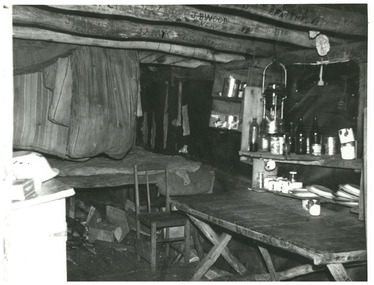
 Falls Creek Historical Society
Photograph - Inside Pretty Valley Camp Kitchen
MEYER COLLECTION - FALLS CREEK PHOTOS In 1947 a determined group of like-minded State Electricity Commission (SEC) staff including Ray Meyer, the chief surveyor of the Kiewa Hydro-Electric Scheme, had a common interest that revolved around the skiing potential of the snow-covered high plains which included what is now the resort of Falls Creek. The six SEC employees, Toni St Elmo, Ray Meyer, Jack Minogue, Lloyd Dunn, Adrian Ruffenacht and Dave Gibson (together with their families) banded together to secretly build a 'hut' that was the first ski lodge at Falls Creek. Using a road built in 1930s to gain access to Falls Creek, their hut project was carried out in secret as efforts by other skiers were blocked by H.H.C. Williams – the engineer in charge of the Hydro Scheme. In 1946 Ray Meyer made a trip to the Lands Office in Melbourne. He came away with a 99-year lease on three acres that was ideally suited for a hut designed by Lloyd Dunn. Adrian Ruffenacht (Design Engineer for the KHS) had suggested where the group should build because of easy access to a spring for water. Much of the building material required was scavenged from derelict huts on the high plains. Due to the need for secrecy, the determined group worked on the hut in the evenings and weekends to avoid detection. During the building period the group had met at Echidna Rock (now known as Eagle Rock) where Skippy St Elmo announced, "This is my favourite ‘Skyline’.” And so the first lodge in the area at Falls Creek Ski Resort came into existence. With the development of the International Poma in the 1970s, the Skyline Lodge, which was sited between the ski-lift’s pole one and pole two, was demolished. However, the legacy of Ray Meyer, Toni St Elmo, Jack Minogue, Lloyd Dunn, Adrian Ruffenacht and Dave Gibson and Skyline lives on in the vibrant atmosphere of Falls Creek Resort. The MEYER COLLECTION documents developments on the Kiewa Hydro Scheme and their life at Falls Creek from the mid 1930s to 1960s.This image is significant because it documents the development of the Kiewa Hydroelectric Scheme.A black and white photo taken inside the Pretty Valley Camp kitchen. Staff quarters was completed in April, 1947 and accommodation for workmen commenced in 1948 but was suspended from May until November. Construction of this camp was completed in 1949. A large dam was proposed at this site but it was never constructed, being replaced by a smaller diversion dam.falls creek, victorian snowfields, pretty valley -
 Falls Creek Historical Society
Photograph - Mt McKay, Bogong High Plains
MEYER COLLECTION - FALLS CREEK PHOTOS In 1947 a determined group of like-minded State Electricity Commission (SEC) staff including Ray Meyer, the chief surveyor of the Kiewa Hydro-Electric Scheme, had a common interest that revolved around the skiing potential of the snow-covered high plains which included what is now the resort of Falls Creek. The six SEC employees, Toni St Elmo, Ray Meyer, Jack Minogue, Lloyd Dunn, Adrian Ruffenacht and Dave Gibson (together with their families) banded together to secretly build a 'hut' that was the first ski lodge at Falls Creek. Using a road built in 1930s to gain access to Falls Creek, their hut project was carried out in secret as efforts by other skiers were blocked by H.H.C. Williams – the engineer in charge of the Hydro Scheme. In 1946 Ray Meyer made a trip to the Lands Office in Melbourne. He came away with a 99-year lease on three acres that was ideally suited for a hut designed by Lloyd Dunn. Adrian Ruffenacht (Design Engineer for the KHS) had suggested where the group should build because of easy access to a spring for water. Much of the building material required was scavenged from derelict huts on the high plains. Due to the need for secrecy, the determined group worked on the hut in the evenings and weekends to avoid detection. During the building period the group had met at Echidna Rock (now known as Eagle Rock) where Skippy St Elmo announced, "This is my favourite ‘Skyline’.” And so the first lodge in the area at Falls Creek Ski Resort came into existence. With the development of the International Poma in the 1970s, the Skyline Lodge, which was sited between the ski-lift’s pole one and pole two, was demolished. However, the legacy of Ray Meyer, Toni St Elmo, Jack Minogue, Lloyd Dunn, Adrian Ruffenacht and Dave Gibson and Skyline lives on in the vibrant atmosphere of Falls Creek Resort. The MEYER COLLECTION documents developments on the Kiewa Hydro Scheme and their life at Falls Creek from the mid 1930s to 1960s.This image is significant because it depicts activities in the life of a pioneering family of Falls Creek area.A black and white photo of Phil Gabillot and Ray Meyer looking towards Mt. McKay and the High Plains. Phil Gabillot was in charge of "Trois Es', the French tunnel construction company and Ray Meyer was Chief Surveyor of the Kiewa Scheme at this time.falls creek, victorian snowfields, mt kckay, bogong high plains, ray meyer, phil gabillot -
 Falls Creek Historical Society
Photograph - Rocky Valley Camp
MEYER COLLECTION - FALLS CREEK PHOTOS In 1947 a determined group of like-minded State Electricity Commission (SEC) staff including Ray Meyer, the chief surveyor of the Kiewa Hydro-Electric Scheme, had a common interest that revolved around the skiing potential of the snow-covered high plains which included what is now the resort of Falls Creek. The six SEC employees, Toni St Elmo, Ray Meyer, Jack Minogue, Lloyd Dunn, Adrian Ruffenacht and Dave Gibson (together with their families) banded together to secretly build a 'hut' that was the first ski lodge at Falls Creek. Using a road built in 1930s to gain access to Falls Creek, their hut project was carried out in secret as efforts by other skiers were blocked by H.H.C. Williams – the engineer in charge of the Hydro Scheme. In 1946 Ray Meyer made a trip to the Lands Office in Melbourne. He came away with a 99-year lease on three acres that was ideally suited for a hut designed by Lloyd Dunn. Adrian Ruffenacht (Design Engineer for the KHS) had suggested where the group should build because of easy access to a spring for water. Much of the building material required was scavenged from derelict huts on the high plains. Due to the need for secrecy, the determined group worked on the hut in the evenings and weekends to avoid detection. During the building period the group had met at Echidna Rock (now known as Eagle Rock) where Skippy St Elmo announced, "This is my favourite ‘Skyline’.” And so the first lodge in the area at Falls Creek Ski Resort came into existence. With the development of the International Poma in the 1970s, the Skyline Lodge, which was sited between the ski-lift’s pole one and pole two, was demolished. However, the legacy of Ray Meyer, Toni St Elmo, Jack Minogue, Lloyd Dunn, Adrian Ruffenacht and Dave Gibson and Skyline lives on in the vibrant atmosphere of Falls Creek Resort. The MEYER COLLECTION documents developments on the Kiewa Hydro Scheme and their life at Falls Creek from the mid 1930s to 1960s.This image is significant because it depicts aspects of the development of the Kiewa Hydroelectric Scheme.A black and white image of Rocky Valley Camp. Work began on the Rocky Valley Dam site in early 1947 and continued until May. It resumed in October after the winter and a camp for the accommodation of workmen was commenced at this time. Work continued in 1948 with the establishment of work facilities, including the erection of two large excavators. The Rocky Valley Dam was completed in 1959.falls creek, victorian snowfields, rocky valley camp -
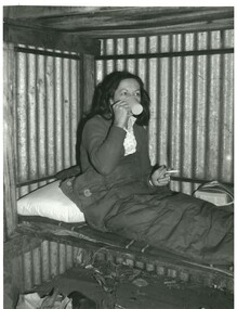
 Falls Creek Historical Society
Photograph - Inside Skyline Lodge
MEYER COLLECTION - FALLS CREEK PHOTOS In 1947 a determined group of like-minded State Electricity Commission (SEC) staff including Ray Meyer, the chief surveyor of the Kiewa Hydro-Electric Scheme, had a common interest that revolved around the skiing potential of the snow-covered high plains which included what is now the resort of Falls Creek. The six SEC employees, Toni St Elmo, Ray Meyer, Jack Minogue, Lloyd Dunn, Adrian Ruffenacht and Dave Gibson (together with their families) banded together to secretly build a 'hut' that was the first ski lodge at Falls Creek. Using a road built in 1930s to gain access to Falls Creek, their hut project was carried out in secret as efforts by other skiers were blocked by H.H.C. Williams – the engineer in charge of the Hydro Scheme. In 1946 Ray Meyer made a trip to the Lands Office in Melbourne. He came away with a 99-year lease on three acres that was ideally suited for a hut designed by Lloyd Dunn. Adrian Ruffenacht (Design Engineer for the KHS) had suggested where the group should build because of easy access to a spring for water. Much of the building material required was scavenged from derelict huts on the high plains. Due to the need for secrecy, the determined group worked on the hut in the evenings and weekends to avoid detection. During the building period the group had met at Echidna Rock (now known as Eagle Rock) where Skippy St Elmo announced, "This is my favourite ‘Skyline’.” And so the first lodge in the area at Falls Creek Ski Resort came into existence. With the development of the International Poma in the 1970s, the Skyline Lodge, which was sited between the ski-lift’s pole one and pole two, was demolished. However, the legacy of Ray Meyer, Toni St Elmo, Jack Minogue, Lloyd Dunn, Adrian Ruffenacht and Dave Gibson and Skyline lives on in the vibrant atmosphere of Falls Creek Resort. The MEYER COLLECTION documents developments on the Kiewa Hydro Scheme and their life at Falls Creek from the mid 1930s to 1960s.This image is significant because it depicts aspects of the life of a pioneering family of Falls Creek and the founders of "Skyline", the first lodge at Falls Creek.A black and white image of four people around the table in Skyline Lodge. L to R:- Sandy McNab, Joan Meyer, Rel Gibbs and Ray Meyer.falls creek, victorian snowfields, rocky valley camp -
 Falls Creek Historical Society
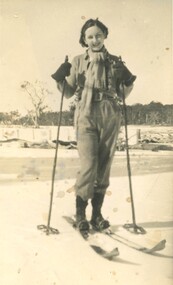
Photograph - Joan Martin (Meyer) on skis
MEYER COLLECTION - FALLS CREEK PHOTOS In 1947 a determined group of like-minded State Electricity Commission (SEC) staff including Ray Meyer, the chief surveyor of the Kiewa Hydro-Electric Scheme, had a common interest that revolved around the skiing potential of the snow-covered high plains which included what is now the resort of Falls Creek. The six SEC employees, Toni St Elmo, Ray Meyer, Jack Minogue, Lloyd Dunn, Adrian Ruffenacht and Dave Gibson (together with their families) banded together to secretly build a 'hut' that was the first ski lodge at Falls Creek. Using a road built in 1930s to gain access to Falls Creek, their hut project was carried out in secret as efforts by other skiers were blocked by H.H.C. Williams – the engineer in charge of the Hydro Scheme. In 1946 Ray Meyer made a trip to the Lands Office in Melbourne. He came away with a 99-year lease on three acres that was ideally suited for a hut designed by Lloyd Dunn. Adrian Ruffenacht (Design Engineer for the KHS) had suggested where the group should build because of easy access to a spring for water. Much of the building material required was scavenged from derelict huts on the high plains. Due to the need for secrecy, the determined group worked on the hut in the evenings and weekends to avoid detection. During the building period the group had met at Echidna Rock (now known as Eagle Rock) where Skippy St Elmo announced, "This is my favourite ‘Skyline’.” And so the first lodge in the area at Falls Creek Ski Resort came into existence. With the development of the International Poma in the 1970s, the Skyline Lodge, which was sited between the ski-lift’s pole one and pole two, was demolished. However, the legacy of Ray Meyer, Toni St Elmo, Jack Minogue, Lloyd Dunn, Adrian Ruffenacht and Dave Gibson and Skyline lives on in the vibrant atmosphere of Falls Creek Resort. The MEYER COLLECTION documents developments on the Kiewa Hydro Scheme and their life at Falls Creek from the mid 1930s to 1960s.This image is significant because it depicts aspects of the life of a pioneering family of Falls Creek and the founders of "Skyline", the first lodge at Falls Creek.A black and white image of Joan Martin (later Meyer) on the first day she skied. Taken on the Omeo Road, Dinner Plain in 1936. Joan was then aged 20 years old.falls creek, victorian snowfields, dinner plain, joan martin, joan meyer -
 Falls Creek Historical Society
Photograph - Ray, Joan and John Meyer
MEYER COLLECTION - FALLS CREEK PHOTOS In 1947 a determined group of like-minded State Electricity Commission (SEC) staff including Ray Meyer, the chief surveyor of the Kiewa Hydro-Electric Scheme, had a common interest that revolved around the skiing potential of the snow-covered high plains which included what is now the resort of Falls Creek. The six SEC employees, Toni St Elmo, Ray Meyer, Jack Minogue, Lloyd Dunn, Adrian Ruffenacht and Dave Gibson (together with their families) banded together to secretly build a 'hut' that was the first ski lodge at Falls Creek. Using a road built in 1930s to gain access to Falls Creek, their hut project was carried out in secret as efforts by other skiers were blocked by H.H.C. Williams – the engineer in charge of the Hydro Scheme. In 1946 Ray Meyer made a trip to the Lands Office in Melbourne. He came away with a 99-year lease on three acres that was ideally suited for a hut designed by Lloyd Dunn. Adrian Ruffenacht (Design Engineer for the KHS) had suggested where the group should build because of easy access to a spring for water. Much of the building material required was scavenged from derelict huts on the high plains. Due to the need for secrecy, the determined group worked on the hut in the evenings and weekends to avoid detection. During the building period the group had met at Echidna Rock (now known as Eagle Rock) where Skippy St Elmo announced, "This is my favourite ‘Skyline’.” And so the first lodge in the area at Falls Creek Ski Resort came into existence. With the development of the International Poma in the 1970s, the Skyline Lodge, which was sited between the ski-lift’s pole one and pole two, was demolished. However, the legacy of Ray Meyer, Toni St Elmo, Jack Minogue, Lloyd Dunn, Adrian Ruffenacht and Dave Gibson and Skyline lives on in the vibrant atmosphere of Falls Creek Resort. The MEYER COLLECTION documents developments on the Kiewa Hydro Scheme and their life at Falls Creek from the mid 1930s to 1960s.This image is significant because it depicts aspects of the life of a pioneering family of Falls Creek and the founders of "Skyline", the first lodge at Falls Creek.A set of four photos of the Meyer Family. 1. Ray Meyer at the SEC office at Bogong 1946 2. Joan and John Meyer at No r. Raceline, Kiewa c1950 3. Ray and John Meyer at West Kiewa, No.5 c1950 4. John Meyer at West Kiewa, No.5 c1950falls creek, victorian snowfields, dinner plain, joan martin, joan meyer