Showing 613 items matching "city square"
-
 City of Greater Bendigo - Civic Collection
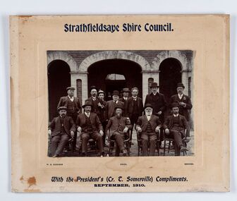
Photograph - Councillor group portrait, W H Robinson, Strathfieldsaye Shire Council
The district of Strathfieldsaye was proclaimed in 1861 and named a Shire on the 17th September in 1866. It remained a shire until amalgamation in 1994 when it became part of the City of Greater Bendigo. The shire was located 8 km to the south- east of Bendigo and covered an area of 601 square kilometres and extended from the Calder Highway to the Coliban and Campaspe Rivers. The shire's administration centre was in Strathfieldsaye until 1972 when new offices were opened in Kennington. Group portrait of 13 men / councilors, 5 seated and 8 standing dressed in suits. There are another 2 men further back in front of the hall doors. Photograph is taken outside the Strathfieldsaye Shire Hall.Srathfieldsaye Shire Council. / With the President's (Cr T. Somerville) Compliments. / September, 1910 / W.H. Robinson Photo. Bendigo Verso; William Drechslershire of strathfieldsaye, president of strathfieldsaye shire, strathfieldsaye shire council -
 City of Greater Bendigo - Civic Collection
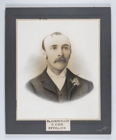
Photograph - Portrait of Councillor Orr, The Yeoman Studios, Ex. Councillor / F. Orr / Eppalock
The district of Strathfieldsaye was proclaimed in 1861 and named a Shire on the 17th September in 1866. It remained a shire until amalgamation in 1994 when it became part of the City of Greater Bendigo. The shire was located 8 km to the south- east of Bendigo and covered an area of 601 square kilometres and extended from the Calder Highway to the Coliban and Campaspe Rivers. The shire's administration centre was in Strathfieldsaye until 1972 when new offices were opened in Kennington. Eppalock Ward is one of three wards in the Greater Bendigo municipality which includes the former Strathfieldsaye Shire. Framed black and white head and shoulder portrait with hand coloured detail. Man with profile slightly to right, walrus moustache, image encircled. Photograph is attached to mount card. Hand written title lower centre.Ex. Councillor / F. Orr / Eppalock / The / Yeoman / Studiosshire of strathfieldsaye, councillor orr -
 City of Greater Bendigo - Civic Collection
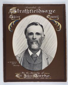
Photograph - Portrait of Councillor Burke
The district of Strathfieldsaye was proclaimed in 1861 and named a Shire on the 17th September in 1866. It remained a shire until amalgamation in 1994 when it became part of the City of Greater Bendigo. The shire was located 8 km to the south- east of Bendigo and covered an area of 601 square kilometres and extended from the Calder Highway to the Coliban and Campaspe Rivers. The shire's administration centre was in Strathfieldsaye until 1972 when new offices were opened in Kennington. Framed black and white head and shoulder portrait of Councillor Burke with hand coloured and drawn detail. Profile centre facing with beard. Cut oval brown mount decorated with text and fscrolls. Hand written title top and lower centre. Wooden frame with detail and gold inner.Presented to Strathfieldsaye / shire Council / w. H. robinson / Photo / Bendigo / By the family of / Cr John Burke / President 1890 - 1899 - 1900strathfieldsaye shire council, councillor burke, president of strathfieldsaye shire -
 City of Greater Bendigo - Civic Collection
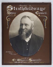
Photograph - Portrait of Councillor Thomas Somerville, W H Robinson
The district of Strathfieldsaye was proclaimed in 1861 and named a Shire on the 17th September in 1866. It remained a shire until amalgamation in 1994 when it became part of the City of Greater Bendigo. The shire was located 8 km to the south- east of Bendigo and covered an area of 601 square kilometres and extended from the Calder Highway to the Coliban and Campaspe Rivers. The shire's administration centre was in Strathfieldsaye until 1972 when new offices were opened in KenningtonFramed black and white head and shoulder portrait of Councillor Somerville with hand drawn detail. Profile slightly to left, face has full beard. Cut oval brown mount decorated with text and scrolls. Hand written title top and lower centre.Presented to / Strathfieldsaye / Shire Council / W. H. Robinson / Photo / Bendigo / by / Cr Thomas Somerville / President 1892 - 3. 1901.2. 1910.11 strathfieldsaye shire council, councillor somerville, president of strathfieldsaye shire -
 City of Greater Bendigo - Civic Collection
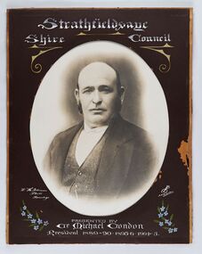
Photograph - Portrait of Councillor Michael Condon, W H Robinson
The district of Strathfieldsaye was proclaimed in 1861 and named a Shire on the 17th September in 1866. It remained a shire until amalgamation in 1994 when it became part of the City of Greater Bendigo. The shire was located 8 km to the south- east of Bendigo and covered an area of 601 square kilometres and extended from the Calder Highway to the Coliban and Campaspe Rivers. The shire's administration centre was in Strathfieldsaye until 1972 when new offices were opened in KenningtonFramed black and white head and shoulder portrait of Councillor Condon with hand coloured and drawn detail. Profile slightly to left. No facial hair. Cut oval brown mount decorated with text, scrolls and flowers. Hand written title top and lower centre.Strathfieldsaye / Shire / Council / W. H. Robinson / Photo / Bendigo / JMB Gribble / Presented by / Cr Michael Condon / President 1889 - 90. 1895-6. 1904 - 5strathfieldsaye shire council, president of strathfieldsaye shire, councillor condon -
 City of Greater Bendigo - Civic Collection
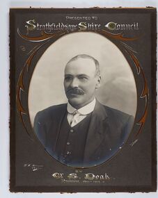
Photograph - Portrait of Councillor Doak, W H Robinson
The district of Strathfieldsaye was proclaimed in 1861 and named a Shire on the 17th September in 1866. It remained a shire until amalgamation in 1994 when it became part of the City of Greater Bendigo. The shire was located 8 km to the south- east of Bendigo and covered an area of 601 square kilometres and extended from the Calder Highway to the Coliban and Campaspe Rivers. The shire's administration centre was in Strathfieldsaye until 1972 when new offices were opened in Kennington.Framed black and white head and shoulder portrait of Councillor Doak with hand coloured and drawn detail. Left facing profile with walrus moustache. Cut oval brown mount decorated with text and scrolls. Hand written title top and lower centre.Presented to / Strathfieldsaye Shire Council / W. H. Robinson / Photo / JMB Gribble / by Cr S. Doak / President 1911 - 1912strathfieldsaye shire council, president of strathfieldsaye shire, councillor doak -
 City of Greater Bendigo - Civic Collection
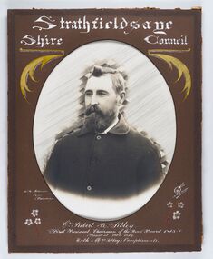
Photograph - Portrait of Councillor Sibley, W H Robinson
The district of Strathfieldsaye was proclaimed in 1861 and named a Shire on the 17th September in 1866. It remained a shire until amalgamation in 1994 when it became part of the City of Greater Bendigo. The shire was located 8 km to the south- east of Bendigo and covered an area of 601 square kilometres and extended from the Calder Highway to the Coliban and Campaspe Rivers. The shire's administration centre was in Strathfieldsaye until 1972 when new offices were opened in KenningtonFramed black and white head and shoulder portrait of Councillor Sibley with hand coloured and drawn detail. Profile slightly to left with walrus moustache and beard. Cut oval brown mount decorated with text, flowers and scrolls. Hand written title top and lower centre.Strathfieldsaye / Shire Council / W m Robinson / Photo / Bendigo / J N B Gribble / Cr Robert R Sibley / First President Chairman of the Road Board 1865 - 5 / President 1866 - 1869 / With Mrs Sibley's Complimentsstrathfieldsaye shire council, councillor sibley, president of strathfieldsaye shire -
 City of Greater Bendigo - Civic Collection
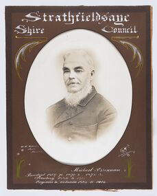
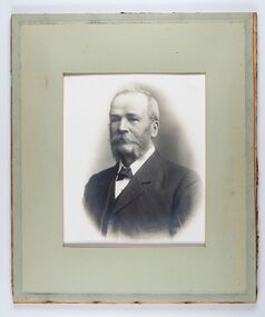
Photograph - Portrait of Councillor Brennan, W H Robinson
The district of Strathfieldsaye was proclaimed in 1861 and named a Shire on the 17th September in 1866. It remained a shire until amalgamation in 1994 when it became part of the City of Greater Bendigo. The shire was located 8 km to the south- east of Bendigo and covered an area of 601 square kilometres and extended from the Calder Highway to the Coliban and Campaspe Rivers. The shire's administration centre was in Strathfieldsaye until 1972 when new offices were opened in Kennington. Councillor Michael Brennan held roles of Shire Secretary and Clark of Works until around 1998 when his son R. B. Brennan was appointed Assistant Secretary and then Shire Secretary to assist his father with the work load during his later years. Michael Brennan remained Clerk of Works until his death at which time his son was appointed to the duties previously held by his father. Framed black and white head and shoulder portrait of Councillor Brennan with hand coloured and drawn detail. Profile to left. Cut oval brown mount decorated with text and flowers. Hand written title top and lower centreStrathfieldsaye / Shire Council / W H Robinson / Photo / Bendigo / J H B Gribble / Michael Brennan / President 1869 - 70. 1871 - 2. 1872 - 3 / Secretary 1882 to 1900 / Engineer & Valuator 1882 to 1902strathfieldsaye shire council, councillor brennan, president of strathfieldsaye shire -
 City of Greater Bendigo - Civic Collection
Photograph - Portrait of Councillor Long, Talma & Co
The district of Strathfieldsaye was proclaimed in 1861 and named a Shire on the 17th September in 1866. It remained a shire until amalgamation in 1994 when it became part of the City of Greater Bendigo. The shire was located 8 km to the south- east of Bendigo and covered an area of 601 square kilometres and extended from the Calder Highway to the Coliban and Campaspe Rivers. The shire's administration centre was in Strathfieldsaye until 1972 when new offices were opened in Kennington.Framed black and white head and shoulder portrait of Councillor Long. Profile to left with walrus moustache and mutton chops. Cut olive retangle mount. Verso; Long. On under board which has photograph attached; Talma & Co. / 119 Swanston St., / Melbournestrathfieldsaye shire council, councillor long -
 City of Greater Bendigo - Civic Collection
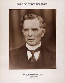
Photograph - Portrait of Shire Secretary Brennan, Unknown
The district of Strathfieldsaye was proclaimed in 1861 and named a Shire on the 17th September in 1866. It remained a shire until amalgamation in 1994 when it became part of the City of Greater Bendigo. The Shire was located 8 km to the south- east of Bendigo and covered an area of 601 square kilometres and extended from the Calder Highway to the Coliban and Campaspe Rivers. The shire's administration centre was in Strathfieldsaye until 1972 when new offices were opened in Kennington. Secretary Brennan, son of Councillor M. Brennan was appointed after his fathers death to the role and according to the The Bendigo Independent was in the role in 1917. See References.Framed black and white head and shoulder portrait of Councillor Brennan. Profile slightly to left. Cut rectangle cream mount. Hand written title top and lower centre. Shire of Strathfieldsaye / R. B. Brennan, Esq / Secretarystrathfieldsaye shire council, secretary strathfieldsaye shire -
 City of Greater Bendigo - Civic Collection
Photograph - Portrait of Councillor Hargraves, Bartlett Bros
The district of Strathfieldsaye was proclaimed in 1861 and named a Shire on the 17th September in 1866. It remained a shire until amalgamation in 1994 when it became part of the City of Greater Bendigo. The shire was located 8 km to the south- east of Bendigo and covered an area of 601 square kilometres and extended from the Calder Highway to the Coliban and Campaspe Rivers. The shire's administration centre was in Strathfieldsaye until 1972 when new offices were opened in KenningtonFramed black and white head and shoulder portrait of Councillor Hargraves. Profile slightly to right with walrus moustache. Cut rectangle brown mount decorated with coloured text and scrolls. Hand written title top and lower centre.Strathfiledsaye Shire Council / Cr John Hargreaves / President 1919 - 20 1928 - 29 / Presented by his Wife & Familystrathfieldsaye shire council, president of strathfieldsaye shire, councillor hargreaves -
 City of Greater Bendigo - Civic Collection
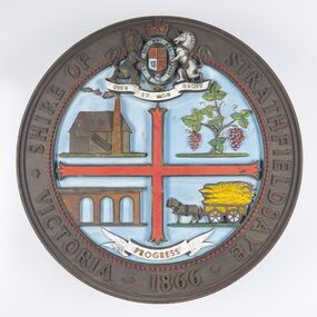
Sign - Shire of Strathfieldsaye Coat of Arms
The district of Strathfieldsaye was proclaimed in 1861 and named a Shire on the 17th September in 1866. It remained a shire until amalgamation in 1994 when it became part of the City of Greater Bendigo. The shire was located 8 km to the south- east of Bendigo and covered an area of 601 square kilometres and extended from the Calder Highway to the Coliban and Campaspe Rivers. The shire's administration centre was in Strathfieldsaye until 1972 when new offices were opened in Kennington. This coat of arms was commissioned for the front of the shire hall building.Brass painted coat of arms or emblem within a circle of the Shire of Strathfieldsaye. Outer rim contains text: SHIRE OF STRATHFIELDSAYE VICTORIA 1866 with the shield of the monarch of the United Kingdom centre top. The shield is divided into four parts with images reflecting the leading industries of the time; wine growing, mining, farming and tanning. The motto PROGRESS is depicted lower centre of shield. SHIRE OF STRATHFIELDSAYE / VICTORIA / 1866 / PROGRESSshire of strathfieldsaye, city of greater bendigo amalgamation, city of greater bendigo signs -
 City of Greater Bendigo - Civic Collection
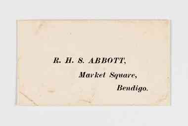
Document - Envelope, RHS Abbott
Richard Hartley Smith Abbott was the step son of Joseph Henry Abbott and inherited his families business interests, building successful commercial enterprises such as Abbott Supply Co. He was elected a representative in the Mandurang riding in the Shire of Strathfieldsaye in 1887, served as Mayor of the City of Bendigo from 1917 - 1918 and a member of the legislative Council of Victoria. He was Secretary of the Bendigo Art Gallery for over 20 years.Small envelope with RHS Abbott address printed on front. Open at back. R. H. S. Abbott, / Market Square, / Bendigo.mayor rhs abbott, shire of strathfieldsaye, bendigo art gallery, city of greater bendigo commerce -
 City of Greater Bendigo - Civic Collection
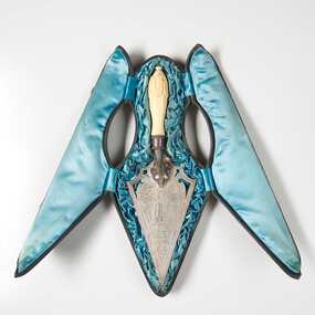
Ceremonial object - Engraved Silver Trowel, Bendigo and Eaglehawk Electric Light and Tramway Powerhouse, 1901
This trowel was presented to City of Bendigo Mayor, Simeon Ryan by Mr B. Deakin the Australian representative of the Victorian Electric Supply Company on the occasion of the laying of the foundation stone for the new power house building in Hargreaves Street, Bendigo. This power house was built to supply power to both Bendigo and Eaglehawk and the overhead power system for the tramway which ran from Quarry Hill, through the city to Eaglehawk and from Golden Square to Lake Weeroona. The building of the power house changed Eaglehawk and Bendigo as street lights were installed and houses became electrified. A report in the Bendigo Independent in 1902 reported ' Night will then be almost as brilliant as the day and people .... who live in the suburbs are to be provided with a tram service worth of the name'. (See reference A Mammoth Scheme.) The tramways closed in April 1972 after the Victorian Parliament granted the SEC an application to cease operating. Today Bendigo Trust operates the tourist trams which run along Pall Mall and welcomes over 40,000 visitors annually. The Bendigo Tramways Depot is the oldest operating tram depot in Australia and is listed on the Victorian Heritage Register. There are currently 45 trams in the fleet (13 of which operate as part of the 'Talking' Tram service).For more about the history and to tour the tramways visit www.bendigotramways.com.Triangular shaped silver engraved trowel with ivory handle (0286a). Top face of trowel is ornately engraved with floral and decorative motifs and an image of an electric tram and two power poles. Reverse has engraved text. No makers mark detected. Housed in a leather covered case (0286b), lined with ruched blue silk. Case has two brass hinges and two small brass clasps.PRESENTED / By / THE ELECTRIC SUPPLY CO / OF VICTORIA TO / SIMEON RYAN. ESQ JP. / MAYOR OF BENDIGO / ON THE OCCASION OF HIS LAYING / THE MEMORIAL STONE OF THE / BENDIGO AND EAGLEHAWK / ELECTRIC LIGHT AND TRAMWAY / POWER HOUSE / 26th JUNE, 1901/ STERLING SILVERcouncillor simeon ryan, councillor s h mc gowan, councillor john hoskins, councillor george loudon, councillor john green, councillor alfred hicks, borough of eaglehawk, borough of eaglehawk mayor, mayor loudon, city of bendigo mayor, mayor ryan, bendigo and eaglehawk tramway -
 City of Greater Bendigo - Civic Collection
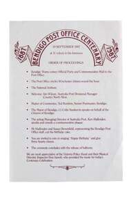
Souvenir - Bendigo Post Office Centenary Ephemera, Ted Rankins, 1987
When the Commonwealth Post and Telegraph Act was passed in June 1902, and a national Postmaster General's Department (the PMG) was established the responsibility the nation's mail and telephone services fell on local Post Offices. The Bendigo Post Office was designed by Public Works architect George W Watson and constructed between 1883 and 1887. The two story brick structure with basement has unpainted rendered facades and a 43m high clock tower complete with 6 bell carillon. The facades are elaborately decorated with Corinthian pilasters, balustrading, lions' heads and the state mansard roof with cast iron ridging and finials. (VHR #4739). Situated on Pall Mall it has always been called the Bendigo Post Office even though it was not until 1891 that the name Bendigo was given to the town. The Bendigo Post Office housed much more than just postal services and the building contained many early government departments and services needed for a growing district. The building celebrated its centenary on the 30th September 1987 to much fan fare with Ted Rankins, the then Postal Manager planning many of the week long events including tours of the post office, a grand parade with cake and staff in period costume, a ball at the Shamrock and a barbeque in Rosalind Park. The Post Office ceased providing postal services in 1997 after the privitisation Australia Post and Telstra but continues to play a central role for the community, providing important services to visitors and locals alike. Currently it is occupied by Bendigo Tourism and includes two exhibition spaces including the Living Arts Space and Djaa Djuwima a dedicated and permanent First Nations Gallery. Activities at the Post Office are supported by City of Greater Bendigo staff and a dedicated group of volunteers. These items are part of the postal collection donated by the Rankins family in memory of the last postal manager at the Bendigo Post Office, Ted Rankins. 0364.1: Single sided printed 'Order of Proceedings' flyer; Outlines the running of events for the celebrations on Wednesday 30 September, 1987 at the Post Office with the centenary logo centre top in crimson ink. 0364.2: Single sided, four-colour printed, DL size invitation for celebrations marking the centenary of the Post Office on Wednesday 30 September, 1987. 0364.3,.4,.5,.6,.7: Printed cake bag with centenary logo and image of Bendigo Post Office printed on front in crimson ink. 0364.8,.9,.10,.11: Square note paper with centenary logo and border printed in crimson ink. 0364.12 Envelope: Australia Post envelope with Bendigo 100th anniversary images. Date stamped and addressed to Mr Edmondston Postmaster, Elmore. bendigo post office, bendigo tourism, city of greater bendigo tourism, post office collection, ted rankins collection, city of greater bendigo volunteers -
 City of Greater Bendigo - Civic Collection
Ceremonial object - Eaglehawk Bell, unknown
The Borough of Eaglehawk was a local government area which covered the northwestern suburbs of the regional city of Bendigo and covered an area of 14.54 square kilometres (5.6 sq mi). Eaglehawk was first incorporated as a borough on 29 July 1862. It had nine councillors, who represented the entire borough. Councillors met at the Town Hall (incorporating the Star Cinema) at the intersection of Sailors Gully Road and Loddon Valley Highway, Eaglehawk. The Town hall has always been the centre of the Borough's activities and was built in 1901 on the site of an earlier town hall which had stood on the location since 1865. The Victorian Heritage Database notes: "The present building replaced this earlier building and was opened on 14 August 1901. The architects were the Melbourne firm of Wilkinson and Permewan. As a much larger and more sumptuous building of brick and stone featuring a central clock tower, the new hall reflected prevailing architectural fashion and was a remarkable investment for a town consisting predominantly of poor mining families. The condition of the town hall is substantially as built. The design is almost identical to the Castlemaine Town Hall." On 7 April 1994, the Borough of Eaglehawk was abolished, and along with the City of Bendigo, the Rural City of Marong and the Shires of Huntly and Strathfieldsaye, was merged into the newly created City of Greater Bendigo.Brass bell with eaglehawk topper / handle on timber stand. The lower front section of the topper has the Borough of Eaglehawk seal attached. No hallmarks or makers stamps visible.borough of eaglehawk, star cinema -
 City of Greater Bendigo - Civic Collection
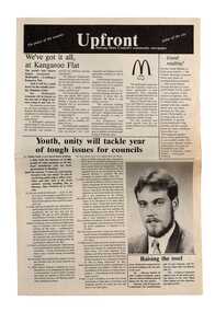
Newspaper, Shire of Marong, Upfront, c 1989
Marong was first incorporated as a road district on 27 August 1861, and became a shire on 23 December 1864. On 1 October 1915, the Borough of Raywood, which was gazetted on 17 January 1865 on 23.31 square kilometres of land 28 kilometres north of Bendigo was united with Marong. On 1 October 1990, the Shire of Marong became a rural city, under the Local Government Act 1989. In a report on 17 February 1994, the Local Government Board recommended that the five councils in the Bendigo region merge to form a "super city", with a population of about 81,000. Marong, Eaglehawk and Huntly had earlier objected to the proposal, and the Board noted a weak no vote against the merger proposal in a referendum in the region; about 70% had voted against, but with a turnout of between 30% and 40% of eligible voters. The three councils filed a writ in the Supreme Court, alleging failure to follow process by the Minister for Local Government, Roger Hallam, but by the time the new "super city" was announced, the writ had not yet been heard, and on 24 March 1994, the Rural City of Marong successfully applied for an injunction blocking the publication of the gazette the following day abolishing the five councils and appointing three commissioners. The government responded by introducing legislation, the City of Greater Bendigo Bill 1994, to Parliament, to effectively override the Supreme Court action, with Hallam saying "the bill would make clear that the Government is determined to achieve its objective for a more efficient municipal structure for the Bendigo region." Marong mayor Robert Hynes described the action as "terribly disappointing", adding, "One way or another, I believe it does mean an end to our fight... it seems the Government are above the law to me." On 6 April 1994, Marong voted to drop the Supreme Court action, effectively in doing so voting itself out of existence, and on 7 April 1994, the Rural City of Marong was abolished, and along with the City of Bendigo, the Borough of Eaglehawk and the Shires of Huntly and Strathfieldsaye, was merged into the newly created City of Greater Bendigo. On 29 April 1994, the Minister confirmed the Bill was not being proceeded with. https://en.wikipedia.org/wiki/Rural_City_of_MarongEight page newspaper style council newsletter providing community updates, news and information. shire of marong, city of greater bendigo amalgamation, councillor phillip eddy, rural city of marong -
 Melton City Libraries
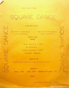
Document, Melton Uniting Church square dance event, 1980
Melton Uniting Church event held at Melton Central Pre-Schoolchurches -
 Melton City Libraries
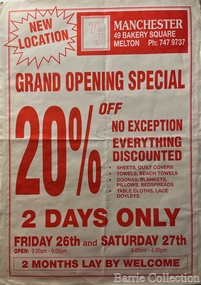
Document, T &J Manchester Grand Opening Special, Unknown
Store opening at Bakery Squaremisc. -
 Melton City Libraries
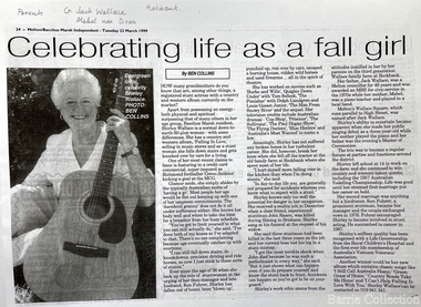
Newspaper, Celebrating life as a fall girl, 1999
Wallace Square- Cr Jack Wallace of Rockbank, served 5 terms as President, unopposed for 46 years. Married Mabel Dixon Shirley Wallace, daughter, Country and Western singer of noteMelton-Bacchus Marsh Independent article of Shirley Wallacelocal identities, council -
 Melton City Libraries
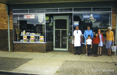
Photograph, Jongebloed Grocery Store, 1970
Bakery Square–Site of 19th Century Jongebloed family bakery, grocery shops and residence demolished 1970 and later hardware shop erected c 1960. Gorrfried Jongebloed was born in 1857 and came to Melton in 1887 as a Captain in the Mercantile Marine. In 1888 he married Marie Antionette, second daughter of Mr Shebler, and took over the bakery and green grocers business. Ten children were born to the family- Gerhard, Annette, Gorrfried (dec 1937), Emil, (dec 1947), Nicholas, Julius, Theckla, Augustus, Marie and Margarethe, - who settled in various parts of Victoria and are, in the bakery businesses. Mr and Mrs Jongebloed senior carried on the businesses in Melton until 1926, when one of their sons Emil, took over. Mr Jongebloed, senior, died in 1930 at the age of 73 years; and his wife living until 8th October 1946, when she died at the age of 80 years. After the sudden death of Emil, in Jan., at the age of 49 years, the business had been conducted by two sons “Pat” and Bryan. Store closed down in 1970 and was demolished in 1976/1977. In the photo left to right isBryan, sister-in-law Shirley. Her children Meryl, Daryl and Debra. Mrs Martha Myers mother of Edna was the photographer. local identities -
 Melton City Libraries
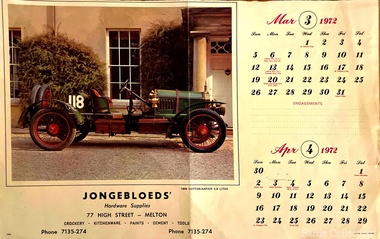
Archive, Jongebloed's Hardware Supplies Calendar, 1972
Bakery Square was the site of 19thCentury Jongebloed family bakery, grocery shops and residence demolished 1970 and later hardware shop erected c 1960. Stables at rear to McKenzie StreetCalendar from the hardware storelocal identities -
 Parks Victoria - Gabo Island Lightstation
Nails
The five types of nails include a stamped steel nail made for wooden flooring; four copper nails used for boat building found at various locations on the island; two steel nails removed from the lantern room door during restoration in 2002 which possibly came with the Chance Bros. lantern room kit delivered in 1862; three galvanised steel nails used to pin the railway track to sleepers and decking on the jetty (the rail track carried a small trolley for unloading stores from supply ships); and a square copper nail found on the rocky shore on Tullaberga Island close to the location of the Monumental City wreck of 1853. The huge American steamer, Monumental City, was wrecked on 15 May 1853. Built in 1850, the ship was the first screw-propulsion steamer to cross the Pacific and was heading back to Sydney after dropping off Californians heading for the Victorian goldfields. Thirty-seven lives were lost, including the owner of the ship, Peter Strobel. A medal was awarded by Sydney residents to Charles Plummer who swam ashore with a line from the wreck. The tragedy renewed the urgency for a lighthouse on Gabo Island, and in 1862 when this was achieved an obelisk was erected as a memorial to those who perished. That year, Victorian PWD architect and designer of the lightstation buildings, Charles Maplestone, gave the following instructions: ‘You may remove the remains of the poor unfortunate shipwrecked of the Monumental City to the site on Gabo you propose but take scrupulous care to collect all the remains and inter them decently under the monument. Pray save any relics’.246 Heritage Victoria has 39 artefacts listed under the Historic Shipwrecks Act (S473) with a clear provenance to the Monumental City. While the copper nail has no documented provenance, it still has contributory significance as part of a diverse assemblage of relics that help to interpret the history of the Gabo Island Lightstation and the numerous shipwrecks that have occurred in its vicinity since the mid nineteenth century..1 Steel nail - flat. Stamped. This type of nail was used for secret nailing of flooring. Source of this nail is unknown. .2 Copper nails. This type of nail was used for boat building. Found at various locations around island. .3 Steel nails. Extracted from lantern room door during restoration 2002. .4 Galvanised steel nails. Used to pin railway track to timber sleepers and decking on jetty. Rail track carried a small trolley used during the unloading of stores from supply ships. .5. Copper nail square. This nail was found on the rocky shore line on Tullaberga Island close to the location of the wreck of the "Monumental City" wrecked May 1853. Nail found in June 2000. -
 Melton City Libraries
Photograph, 'The Rescue' at Bakery Square, 1977
Bunnings and Melton Fresh replaced Magnet Store in Bakery Square.Members of the Melton Fire Brigade at the opening of the 'Magnet Store' in Bakery Squarelocal identities, emergency services, local significant events -
 Melton City Libraries
Photograph, Jongebloed Bakehouse, c.1973
Bakery Square was the location of Jongebloed shop, bakehouse and stables Bakehouse owned by Gottfried Jongebloed and Auguste Shebler. Auguste Shebler came to Melton in the early 1950’s and in 1857 built a store on the corner of High and Smith Streets. Mr Shebler was the Postmaster, and Paymaster for thee Government, who sent a batch of 400 to 500 immigrants to clear trees and fallen timber off the Ballarat Road; the wages being 5/- per day, and oversees 10/- per day. In 1865, Mr Shebler built the Golden Fleece Hotel on the present site and, although many alterations have taken place, most of the main walls still belong to the original building. He built a store some 100 yards west along High Street, and added to it a bakers’s business; then he built a butcher’s shop and leased it to the late Mr G McKenzie. Gorrfried Jongebloed was born in 1857 and came to Melton in 1887 as a Captain in the Mercantile Marine. In 1888 he married Marie Antionette, second daughter of Mr Shebler, and took over the bakery and green grocers business. Ten children were born to the family- Gerhard, Annette, Gorrfried (dec 1937), Emil, (dec 1947), Nicholas, Julius, Theckla, Augustus, Marie and Margarethe, - who settled in various parts of Victoria and are, in the bakery businesses. Mr and Mrs Jongebloed, sen., carried on the businesses in Melton until 1926, when one of their sons Emil, took over. Mr Jongebloed, sen., died in 1930 at the age of 73 years; and his wife living until 8th Oct., 1946, when she died at the age of 80 years. After the sudden death of Emil, in Jan., at the age if 49 years, the business had been conducted up to the present time by two sons “Pat” and Bryan. 1962 Express September local identities -
 City of Kingston
Photograph - Black and white, 3 March 1954
Cheltenham and Moorabbin are suburbs within the City of Kingston that were originally established as rural market gardening communities The area is bordered by Highett and Mentone. The market gardens, farms and paddocks have gradually been sub-divided into housing and industrial estates. Highett is developed with residential homes but was also the site of major facilities such as the Highett Gas Works. This aerial image covers a diverse section of the City of Kingston, taking in the suburbs of Moorabbin, Cheltenham, Highett and Mentone Residential housing development is prominent along the Frankston Railway line and the area still retains extensive market gardens and paddocks yet to be converted to a large industrial and commercial zone.Aerial photograph of Mentone, Cheltenham and Moorabbin within the City of Kingston. The area depicted in this 1954 aerial view includes Warrigal Road and Centre Dandenong Road intersection (top left); Charman Road, Patty Street, Bourke Street, Collins Street Mentone (top right); Keys Road Moorabbin (bottom left); Bay Road, Cheltenham (bottom right), Friendship Square, Cheltenham Park, Victoria Golf Club and Jack Barker Oval are visible. Nepean Highway and the Frankston railway line run centrally through the image. Highett Gasworks is also evident.White handwriting and type [indecipherable]. White image of clockface White image of compass White type 42956 Black handwriting 3/3/54 Williams [indecipherable] Black pencil: S [arrow] Black ink: 3/3/1954cheltenham, moorabbin, mentone, highett, market gardens -
 City of Kingston
Pamphlet - Colour, W. H. Wood Estate Agent, Realising sub-divisional auction sale Bentleigh Park Estate, Bentleigh, 1920
Sales plan for land in the suburb of Bentleigh, bounded by Centre Road, and incorporating subdivisions on either side of Elizabeth Street (Wheatley Road), Oak Street and Beech Street.The developing urban area of Bentleigh within the City of Kingston. This land sale pamphlet illustrates the subdivision of land within the municipality and the changing demographic of the district as new houses are constructed close to infrastructure.Colour pamphlet advertising a realising sub-divisional auction sale of the Bentleigh Park Estate, Bentleigh. Incorporates a map of the estate bordered by Centre Road, and including Elizabeth Street (Wheatley Road), Oak Street and Beech Street.Hand drawn in grey pencil: a small square on subdivision 33 Hand drawn in grey pencil: a small square incorporating a cross on subdivision 24 Hand written in black ink on reverse: Bentleigh Park / Estate / Ward late Andersonsland sales, estate, bentleigh -
 Melbourne Legacy
Document, Early History of the Shrine of Remembrance, c1928
... welcoming the Anzac Square Scheme as a city improvement, cannot... welcoming the Anzac Square Scheme as a city improvement, cannot ...After the first world war there was a decision made to create a memorial. Legatees were involved in the process at various times and capacities. In particular Legatee Kemsley was vocal in idea of a structure over a utilitarian memorial (such as a hospital or a park) - see letter at 01182. These notes include the resolution that passed at the Melbourne Town Hall at a public meeting: "That this meeting of citizens confirm the launching of an appeal by the Lord Mayor to establish a National War Memorial by means of a monument and that an executive committee with the Lord Mayor as Chairman with power to add and point sub-committees be formed to carry out the project." Also that 20 sites were selected for consideration in 1921. Although the St Kilda Road site was favoured early on, by 1926 there was pressure to change to a "provision of square" and Cenotaph at the intersection of Spring and Bourke Streets. Legacy Clubs voiced their opposition to this proposal by passing a resolution "That the Melbourne Legacy Club, representative of the returned soldiers in business in this city, whilst welcoming the Anzac Square Scheme as a city improvement, cannot support it as a War Memorial scheme and affirms its support for the Shrine of Remembrance in the Domain as the only War Memorial worthy of Victoria's unparalleled efforts in the Great War." The document was in an envelope with a letter dated 30 April 1971 (01182) that also outlines the efforts Legacy (especially L/- Kemsley) went through to promote the construction of the Shrine of Remembrance over a proposed square. The envelope says 'The Origin of the Shinre of Remembrance p/p Legatees Kemsley and Joynt'. And the initial 'JMBA'?. It was in a file with other documents concerning the Shrine and it's history.A record of the events that led to the construction of the Shrine of Remembrance as noted by a Legatee at the time. There was an effort to record historical events for the "Archive Committee" which collected this an other documents relating to the Shrine together in a file (see items 01181 - 01190)Five white foolscap pages of black type recording major events in the history of building the Shrine (covering the years from 1926 - 1928).memorial, shrine of remembrance -
 Melbourne Legacy
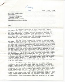
Letter - Document, letter, 1971
... in business in this city, whilst welcoming the Anzac Square Scheme... welcoming the Anzac Square Scheme as a city improvement, cannot ...After the first world war there was a decision made to create a memorial. Legatees were involved in the process at various times and capacities. In particular Legatee Kemsley was vocal when the idea of the St Kilda Road site, which was favoured early on, was overturned and in 1926 there was pressure to change to a "provision of square" and Cenotaph at the intersection of Spring and Bourke Streets. Legacy Clubs voiced their opposition to this proposal by passing a resolution "That the Melbourne Legacy Club, representative of the returned soldiers in business in this city, whilst welcoming the Anzac Square Scheme as a city improvement, cannot support it as a War Memorial scheme and affirms its support for the Shrine of Remembrance in the Domain as the only War Memorial worthy of Victoria's unparalleled efforts in the Great War." The document was in an envelope with the History of the Shrine (01181). The envelope says 'The Origin of the Shrine of Remembrance p/p Legatees Kemsley and Joynt'. And the initial 'JMBA'?. It was in a file with other documents concerning the Shrine and it's history.A record of the events that led to the construction of the Shrine of Remembrance as noted by a Legatee at the time. There was an effort to record historical events for the "Archive Committee" which collected this an other documents relating to the Shrine together in a file with the items given numbest prefixed with an S (see items 01181 - 01190 and 01206 - 01211).A two page carbon copy of a letter typed on white quarto paper. Dated 30 April 1971, it is from Legatee Donovan Joynt to the President of Legacy outlining Legacy's impact in the building the Shrine.Handwritten in blue ink, 'Copy' on front page and signed 'Donovan'.memorial, shrine of remembrance -
 Melbourne Legacy
Document, The Shrine of Remembrance - A Melbourne Legacy Club Memorial
... in business in this city, whilst welcoming the Anzac Square Scheme... welcoming the Anzac Square Scheme as a city improvement, cannot ...After the first world war there was a decision made to create a memorial. Legatees were involved in the process at various times and capacities. In particular Legatee Kemsley was vocal when the idea of the St Kilda Road site, which was favoured early on, was overturned and in 1926 there was pressure to change to a "provision of square" and Cenotaph at the intersection of Spring and Bourke Streets. Legacy Clubs voiced their opposition to this proposal by passing a resolution "That the Melbourne Legacy Club, representative of the returned soldiers in business in this city, whilst welcoming the Anzac Square Scheme as a city improvement, cannot support it as a War Memorial scheme and affirms its support for the Shrine of Remembrance in the Domain as the only War Memorial worthy of Victoria's unparalleled efforts in the Great War." The document was in a file with other documents concerning the Shrine and it's history (01181 - 01190).A record of the events that led to the construction of the Shrine of Remembrance as noted by a Legatee. There was an effort to record historical events for the "Archive Committee" which collected this and other documents relating to the Shrine together in a file (see items 01181 - 01190)White A4 paper with black type written as a circular to Legacy members to outline Legacy's impact in the building the Shrine.memorial, shrine of remembrance