Showing 753 items
matching construction plan
-
 Kew Historical Society Inc
Photograph - Flooding of the Yarra Valley at Kew East, 1974
Flooding of the Yarra Valley, including that section of the Yarra bordering Kew and Kew East in the north and west of the municipality, was a regular occurrence. Extreme flood events of the Yarra River are recorded to have occurred in 1891, 1901, 1916, 1923 and 1934. The Municipality of Kew's response to these floods was to enact planning decisions restricting residential development in flood prone areas following the floods of 1916, 1921 and 1934. While floods continued after the development of the Upper Yarra Reservoir (construction 1948-57), the regularity and extent of these inundations diminished. During the nineteenth century, the land abutting the south side of the Yarra in Kew was devoted to dairy farming. In the twentieth century, before and after the construction of the Eastern Freeway, much of this low-lying area was used as golf courses and public parks.Late example of the capacity of the Yarra Valley at Kew to flood, even though drainage works and the Upper Yarra Reservoir had reduced their regularity.Original black and white print photograph of the low-lying land at East Kew under floodwater on 16 May 1974. The vantage point of the photographer is Lister Street. Flooding was caused by overflowing water in Glass' Creek and the River Yarra. Annotation verso: "Lister St looking same as No.3 / 16 May 1974 11.30"floods, yarra river, glass' creek, lister street -
 Kew Historical Society Inc
Photograph - Flooding of the Yarra Valley at Kew East, 1974
Flooding of the Yarra Valley, including that section of the Yarra bordering Kew and Kew East in the north and west of the municipality, was a regular occurrence. Extreme flood events of the Yarra River are recorded to have occurred in 1891, 1901, 1916, 1923 and 1934. The Municipality of Kew's response to these floods was to enact planning decisions restricting residential development in flood prone areas following the floods of 1916, 1921 and 1934. While floods continued after the development of the Upper Yarra Reservoir (construction 1948-57), the regularity and extent of these inundations diminished. During the nineteenth century, the land abutting the south side of the Yarra in Kew was devoted to dairy farming. In the twentieth century, before and after the construction of the Eastern Freeway, much of this low-lying area was used as golf courses and public parks.Late example of the capacity of the Yarra Valley at Kew to flood, even though drainage works and the Upper Yarra Reservoir had reduced their regularity.Original black and white print photograph of the low-lying land at East Kew under floodwater on 16 May 1974. The vantage point of the photographer is at Willsmere Road. The road itself is underwater.Annotation verso: "Willsmere Rd / Same as No.7 / 16 May 1974 11.15am"floods, yarra river, willsmere road -
 Kew Historical Society Inc
Photograph - Flooding of the Yarra Valley at Kew East, 1974
Flooding of the Yarra Valley, including that section of the Yarra bordering Kew and Kew East in the north and west of the municipality, was a regular occurrence. Extreme flood events of the Yarra River are recorded to have occurred in 1891, 1901, 1916, 1923 and 1934. The Municipality of Kew's response to these floods was to enact planning decisions restricting residential development in flood prone areas following the floods of 1916, 1921 and 1934. While floods continued after the development of the Upper Yarra Reservoir (construction 1948-57), the regularity and extent of these inundations diminished. During the nineteenth century, the land abutting the south side of the Yarra in Kew was devoted to dairy farming. In the twentieth century, before and after the construction of the Eastern Freeway, much of this low-lying area was used as golf courses and public parks.Late example of the capacity of the Yarra Valley at Kew to flood, even though drainage works and the Upper Yarra Reservoir had reduced their regularity.Original black and white print photograph of the low-lying land at East Kew under floodwater on 16 May 1974. The photograph is of Hyde Park looking north-east.Annotation verso: "Hyde Park looking nth-east / Flood Level / 16 May 1974 11.15am / R.L. 46.61"floods, yarra river, hyde park -
 Kew Historical Society Inc
Photograph - Flooding of the Yarra Valley at Kew, 1974
Flooding of the Yarra Valley, including that section of the Yarra bordering Kew and Kew East in the north and west of the municipality, was a regular occurrence. Extreme flood events of the Yarra River are recorded to have occurred in 1891, 1901, 1916, 1923 and 1934. The Municipality of Kew's response to these floods was to enact planning decisions restricting residential development in flood prone areas following the floods of 1916, 1921 and 1934. While floods continued after the development of the Upper Yarra Reservoir (construction 1948-57), the regularity and extent of these inundations diminished. During the nineteenth century, the land abutting the south side of the Yarra in Kew was devoted to dairy farming. In the twentieth century, before and after the construction of the Eastern Freeway, much of this low-lying area was used as golf courses and public parks.Late example of the capacity of the Yarra Valley at Kew to flood, even though drainage works and the Upper Yarra Reservoir had reduced their regularity.Original black and white print photograph of the low-lying land at East Kew under floodwater on 16 May 1974. The photograph is taken from 43 Kellett Grove.Annotation verso: "Kellett Gve No.43 / Flood Level / 16 May 1974 11.40am"floods, yarra river, kellett grove -
 Queen Victoria Women's Centre
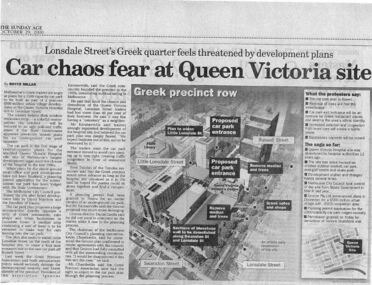
Newspaper excerpt, The Sunday Age, Car Chaos fear at Queen Victoria Site: Lonsdale Street's Greek quarter feels threatened by development plans, 29 October 2000
Newspaper excerpt from The Sunday Age. Page 5 and a smaller introduction probably from the front page. Smaller excerpt colour photo of blue-stone and cast-iron wall which was to be demolished. Larger excerpt, a black and white aerial view of QVWC and the block where it is situated. building construction, building permits, historic building -
 Queen Victoria Women's Centre
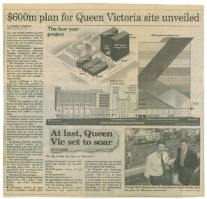
Newspaper clipping, Wayne Taylor, $600m plan for Queen Victoria site unveiled, 21 February 2001
... melbourne Unveiling of the QV plans by Grocon building construction ...Unveiling of the QV plans by Groconnewspaper clipping from The Age. Graphic representing the works to be done on the QV block between Swanston street and Russell street. Black and white photo at the bottom of page of Premier Steve Bracks with director of Grocon, Daniel Grollo after the plans for QV were announced. building construction, historic building, civic centres, town planning -
 Queen Victoria Women's Centre
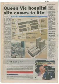
Newspaper excerpt, Queen Vic hospital site comes to life, 24 August 2003
newspaper articles Sunday Herald Sun page 28. colour photograph of the construction works bottom left of article's images. Graphic images of the the construction works and what would be included in the centre.town planning, historic building, retail trade, restaurants, construction and demolition workers -
![Hand-Drawn Plans for Caravan by Frank Lebbell Frost [ca 1915-1924]](/media/collectors/51d110e42162ef12e06aa06b/items/51fb1e922162ef156c79dac3/item-media/52a121752162ef1f0c9c161b/item-fit-380x285.jpg) Beechworth Honey Archive
Beechworth Honey ArchiveHand-Drawn Plans for Caravan by Frank Lebbell Frost [ca 1915-1924]
Hand-drawn plans for two types of homemade caravan. Front Side: Drawing of caravan with detailed measurements. Caravan dimensions; 6 foot 2 inches from ground to top, approx. 5 yards from end to end. Detailed measurements of construction framing, detailed measurements of two beds on wire mattresses. Back Side: Drawing of a caravan. Few details. Drawn with blue pen and grey lead on paper. hand drawn, hand-drawn, plan, caravan, frost, beekeeper, beechworth honey -
 Williamstown Botanic Gardens- Hobsons Bay City Council
Postcard - Williamstown Botanic Gardens, c1900-1920
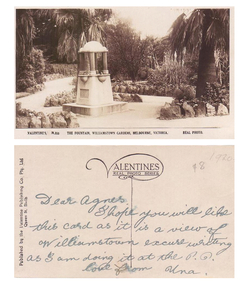
The original postcards in this series (2013.002 to 2013.018) were generously loaned to Williamstown Botanic Gardens by a private collector for copying. The fountain is located on the southern side of the ornamental lake and was erected to celebrate the jubilee of the municipality (17 March 1906). Controversy surrounded the commission for the design and construction of the fountain, as it was originally assigned to a contractor in Carlton. Williamstown residents insisted the fountain be designed and constructed locally, and on December 1906 the fountain was tendered by local firm Bliss and Sons and opened for public use in 1906. The fountain features a symmetrical plan, consisting of fur granite columns supporting a granite canopy and is fully operational following restoration work in 2013. The idea for the fountain came from an elderly resident of Williamstown who suggested the council follow the example of Ballarat’s gardens with its many statues and monuments. The postcards are evidence of the interest the gardens held as a subject for postcard publishers. The text and images provide a snapshot into fashions, social interests and concerns of the time. The professionally produced images provide a pictorial history of Gardens including changing planting styles, various structures and features of the Gardens eg the aviary, cannons, the fountain, the second Curator’s Lodge and gates. The images offer an opportunity to compare garden vistas with the present day. The significance of the fountain is its reflection of how Williamstown people felt for their Gardens and the importance placed on investing in locally operated business. It was noted in the Brief Jottings column of the Williamstown Chronicle, February 24 1906, the fountain is a “We favor the erection of the jubilee fountain in the Giffard-street (Williamstown Botanic) Gardens. Ornaments of that kind there will make that beauty spot even more attractive.” Sepia scene of a fountain situated on paths bordered with rocks. The fountain in on a plinth and the postcard shows the plaque and two of the four drinking stations. The fountain features a symmetrical plan, consisting of four granite columns supporting a granite canopy. Front: VALENTINE’S, M.355 THE FOUNTAIN, WILLIAMSTOWN GARDENS MELBOURNE, VICTORIA. REAL PHOTO. Reverse: vertical on left side of card and underlined: ‘Published by the Valentine & Sons Publishing Co. Ltd. / Queen St, Melb’. Top centre of card: Contains logo of ‘VALENTINES / REAL PHOTO SERIES’. The postcard is addressed to ‘Dear Agnes’ from ‘Una’. Marked in pencil on to right hand corner ‘1920 / $8’ believed to be put on the postcard by the vendor. postcard, gardens, post-card, williamstown-botanic-gardens, hobsons-bay-city-council, jubilee-fountain, fountain drinking-fountain, 1920, granite, bliss-and-sons, 1906 -
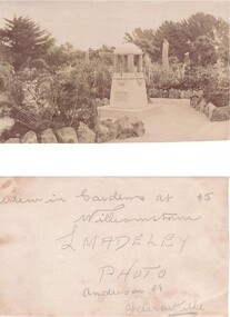 Williamstown Botanic Gardens- Hobsons Bay City Council
Postcard - Willliamstown Botanic Gardens
The original postcards in this series (2013.002 to 2013.018) were generously loaned to Williamstown Botanic Gardens by a private collector for copying. The fountain is located on the southern side of the ornamental lake and was erected to celebrate the jubilee of the municipality (17 March 1906). Controversy surrounded the commission for the design and construction of the fountain, as it was originally assigned to a contractor in Carlton. Williamstown residents insisted the fountain be designed and constructed locally, and on December 1906 the fountain was tendered by local firm Bliss and Sons and opened for public use in 1906. The fountain features a symmetrical plan, consisting of fur granite columns supporting a granite canopy and is fully operational following restoration work in 2013. The idea for the fountain came from an elderly resident of Williamstown who suggested the council follow the example of Ballarat’s gardens with its many statues and monuments. The postcards are evidence of the interest the gardens held as a subject for postcard publishers. The text and images provide a snapshot into fashions, social interests and concerns of the time. The professionally produced images provide a pictorial history of Gardens including changing planting styles, various structures and features of the Gardens eg the aviary, cannons, the fountain, the second Curator’s Lodge and gates. The images offer an opportunity to compare garden vistas with the present day. The significance of the fountain is its reflection of how Williamstown people felt for their Gardens and the importance placed on investing in locally operated business. It was noted in the Brief Jottings column of the Williamstown Chronicle, February 24 1906, the fountain is a “We favor the erection of the jubilee fountain in the Giffard-street (Williamstown Botanic) Gardens. Ornaments of that kind there will make that beauty spot even more attractive.” Sepia scene of a fountain situated on paths bordered with rocks. The fountain in on a plinth with a plaque. The fountain features a symmetrical plan, consisting of four granite columns supporting a granite canopy. High stumps of trees are just behind the fountain with larger trees in the background to the right and left of the image.Postcard, Gardens, Post-Card, Williamstown-Botanic-Gardens, Hobsons-Bay-City-Council, Jubilee-fountain, fountain drinking-fountain, granite, Bliss-and-Sons, Madeleypostcard, gardens, post-card, williamstown-botanic-gardens, hobsons-bay-city-council, jubilee-fountain, fountain drinking-fountain, granite, bliss-and-sons, madeley -
 Vision Australia
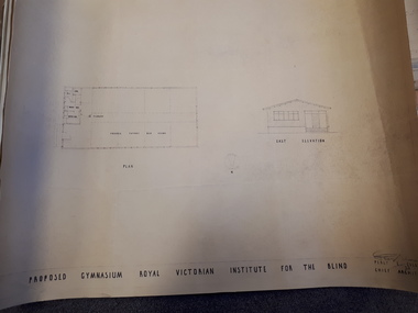
Plan - Image, Proposed Gymnasium Royal Victorian Institute for the Blind, 21 June 1950
... In 1951 plans were made for the construction of a gymnasium... In 1951 plans were made for the construction of a gymnasium ...In 1951 plans were made for the construction of a gymnasium to be situated in the grounds of St Kilda Road. These 4 plans specify the building construction notes, present front and east elevations, and show how part of the hall could be transformed into bedrooms in the future. There are 2 copies of each plan, consisting of identifical copies of the east elevation and different notes printed/handwritten on the front, side and top elevations. These were presented to the RVIB Board in Feburary 1951, according to the stamp on the back.2 architectural plans showing proposed gymnasium buildingPercy E Everett Chief Architectroyal victorian institute for the blind, plans -
 University of Melbourne, Burnley Campus Archives
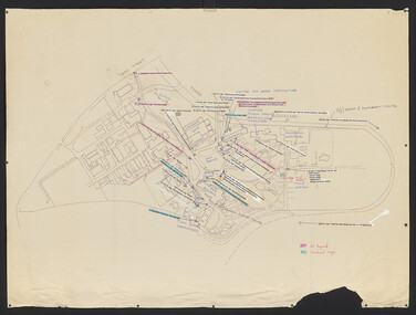
Plan, Landscape Construction Facility/Field Station Entry Development Proposal, 1997-1998
... Construction Facility The same plan, coloured, drawn by Phil Tulk ...The same plan, coloured, drawn by Phil Tulk with different dates: 27.11.1997 and 18.05.1998.phil tulk, field station, landscape construction facility -
 University of Melbourne, Burnley Campus Archives
Plan, Approved Signs for Burnley Gardens, 1996
(1) 2 copies, list of signs with descriptions. (2) Tracing paper copy, Suggested Construction for Interpretative Signs Student Gardens V.C.A.H. Burnley. (3) Plan of Campus with placement of signs as per (1).students, gardens, vcah, signage, burnley gardens -
 University of Melbourne, Burnley Campus Archives
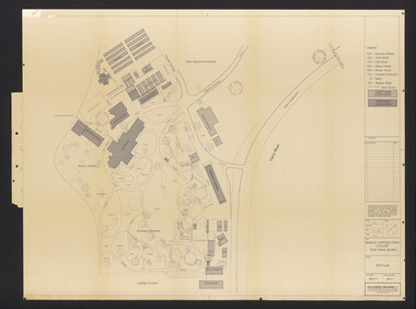
Plan, Burnley Horticultural College: Site Plan, 1983-1984
Plans of the Burnley Campus, Ornamental Gardens from Plan 11.0715 by Alexander Metherell Pty. Ltd. Dated November 1983. Scale 1:500. (1) 5 copies, buildings shaded showing construction type. Job No BHC/1 Drawing No SP/1. Tree placements stamped on, includes legend. (2) 2 copies No SP/1c. In Description column, "A" Building Names 7/02/1984. Also see B15.0352 full report. B11.0715 originals. B11.0599 SP/3.ornamental gardens, burnley campus, burnley horticultural college, alexander metherell p/l -
 University of Melbourne, Burnley Campus Archives
Plan, Construction Details Student Gardens Burnley Campus, 1990
Tracing paper copy, Construction details for student gardens. Dated1 9.09.1990. By JK (Jill Kellow) . Scale 1:100.student gardens, burnley, vcah burnley, jill kellow -
University of Melbourne, Burnley Campus Archives
Plan, Construction detail - Paving; Construction detail - Mower strip, 1990-2000
... ; Construction detail - Mower strip Plan ...Coloured Plans for Courtyards at a hospital. Courtyards: 1,2 and 3; 4; 5; 6; Typical Courtyard Sections; Functional Areas.hospital, courtyard -
University of Melbourne, Burnley Campus Archives
Plan, Construction Detail - Paving; Construction Detail - Mower strip, 1980 - 1990
... ; Construction Detail - Mower strip Plan ...Tracing paper designs (x 2) landscape design, paving, mower strip -
University of Melbourne, Burnley Campus Archives
Plan, Bodalla Aged Care Facility, 2001
Tracing paper copy, Proposed Landscape Drawing 1/1 dated 10.9.2001. Paper Drawing 2/3, dated 30.8.2001. Construction detail sketch with note attached to Jill.landscape design, bodalla aged care facility, kew -
University of Melbourne, Burnley Campus Archives
Plan, Landscape Construction I Paving on Mortar, 1990-2000
... Plan of paving construction. Fall to Grade. Scale 1:20.... Boulevard Richmond melbourne landscape construction paving Plan ...Plan of paving construction. Fall to Grade. Scale 1:20.landscape construction, paving -
University of Melbourne, Burnley Campus Archives
Plan, Power Tool Practical, 1980-1990
Tracing paper and paper copies of plan of where to put bolts and nails in a piece of construction work.tools, construction -
University of Melbourne, Burnley Campus Archives
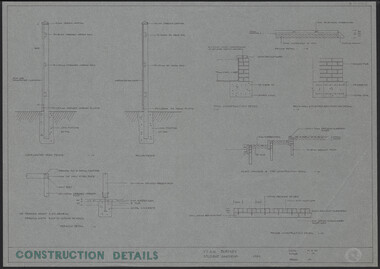
Plan, Construction Drawings, 1980-1990
... and Brick Paving. Construction Drawings Plan ...Tracing paper copy of drawings of Plinth Construction, Staking Method, Seat Detail and Brick Paving.construction -
 University of Melbourne, Burnley Campus Archives
Plan - Plans and photographs, Burnley Low Energy Greenhouse, c. 2008
... construction pamphlet Laminated plans for greenhouse (1) Burnley Low ...Laminated plans for greenhouse (1) Burnley Low Energy Greenhouse, (2) Solar Boosted Heat Pump - Greenhouse Bench Heating System. C photographs pasted on cardboard and labelled (3) Loading 20 mm gravel into Rock pile. (4) Reinforcement at Bottom Gravel level. (5) Sealing the Top of the Rock pile. (6) Top of Rock pile Before A-Frame Construction. (7) Corner Detail of Portal Frame. (8) Glazing Frames for Solar Panels. (9) Structure Partially Clad, with Solar Panel Supports at Rear. (10) Back of Solar Panels in Place. Laminated C photographs pasted on cardboard and labelled. (11) Burnley Low Energy Greenhouse. (12) Greenhouse Covering Materials Burnley. Pamphlet (13) Burnley College Institute of Land and Food Resources (slightly damaged)burnley, greenhouse, solar energy, construction, pamphlet -
University of Melbourne, Burnley Campus Archives
Plan - Colour prints, Burnley Low Energy Greenhouse, c. 2008
Laminated plans for greenhouse (1) Burnley Low Energy Greenhouse, (2) Solar Boosted Heat Pump-Greenhouse Bench heating System. Photographs pasted on cardboard and labelled (3) Loading 20mm gravel into Rockpile. (4) Reinforcement at Bottom Gravel level. (5) Sealing the Top of the Rockpile. (6) Top of Rock pile Before A-Frame Construction. (7) Corner Detail of Portal Frame. (8) Glazing Frames for Solar Panels. (9) Structure Partially Clad, with Solar Panel Supports at Rear. (10) Back of Solar Panels in Place. Laminated photographs pated on cardboard and labelled. (11) Burnley Low Energy Greenhouse. (12) Greenhouse Covering Materials Burnley. Panphlet (13) Burnley College Institute of Land and Food Resources (slightly damaged)greenhouse, burnley, low energy greenhouse, solar boosted heat pump, greenhouses, bench heating system, rockpile -
University of Melbourne, Burnley Campus Archives
Work on paper (item) - Student Work, Sandra Brizga, Andembach - Riverside Garden Planting Plan, 8 November 2018
Made as an assignment for HORT90035, a subject at Burnley Horticultural College coordinated by Andrew Laidlaw. assignment, burnley horticultural college, hort90035 -
University of Melbourne, Burnley Campus Archives
Work on paper (item) - Student Work, Iroshan Gangodawialge, Blackney Residence Garden Landscape Design, 2017
It was made as an assessment for HORT90035 Landscape Construction and Graphics, a subject at Burnley Horticultural College coordinated by Andrew Laidlaw. assignment, burnley horticultural college, hort90035 -
University of Melbourne, Burnley Campus Archives
Work on paper (item) - Student Work, Lucas McGarrigle, Landscape Design Plan, 2018
Made as an assignment for HORT90035, a subject at Burnley Horticultural College coordinated by Andrew Laidlaw. assignment, landscaping, burnley horticultural college, landscape construction and graphics, hort90035 -
University of Melbourne, Burnley Campus Archives
Work on paper (item) - Student Work, Luke Flanagan, Marriott Residence Landscape Design, 2016
Submitted as an assignment for HORT90035, 'Landscape Construction and Graphics,' coordinated by Andrew Laidlaw. assignment, landscape construction and graphics, landscaping, hort90035, burnley horticultural college -
University of Melbourne, Burnley Campus Archives
Work on paper (item) - Student Work, Tim Johns, Blackney Residence Landscape Design, Uncertain, probably 2017-2018
Submitted as an assignment for HORT90035, 'Landscape Construction and Graphics,' a subject at Burnley Horticultural College coordinated by Andrew Laidlaw. assignment, landscape construction and graphics, landscaping, burnley horticultural college, hort90035, andrew laidlaw -
University of Melbourne, Burnley Campus Archives
Work on paper (item) - Student Work, Perry Lane, Glenlyon RD Landscape Design, Uncertain, probably 2017-2018
Submitted as an assignment for HORT90035, 'Landscape Construction and Graphics,' a subject at Burnley Horticultural College coordinated by Andrew Laidlaw. It seems a third sheet of paper is missing, though one of the folders does contain a rubric showing the mark received for this project. assignment, landscaping, burnley horticultural college, landscape construction and graphics, hort90035 -
University of Melbourne, Burnley Campus Archives
Work on paper (item) - Student Work, Jane McKenzie-Smith, Ironbark Designs Landscape Design, 2015
The sheets were submitted as part of a landscape design project, most likely for HORT90035, 'Landscape Construction and Graphics,' a subject at Burnley Horticultural College coordinated by Andrew Laidlaw. It seems there is a third sheet missing that would have been the site analysis component of this project. assignment, landscaping, burnley horticultural college, landscape construction and graphics