Showing 560 items
matching house sales
-
 City of Kingston
Pamphlet - Colour, Arthur Tuckett & Son, Auctioneers and Subdivisional Specialists, Auction of Station Estate, Moorabbin, 1923
Sales plan for land in the suburb of Moorabbin, bounded by Railway Crescent, South Road, Jasper Road and Pattersons Road.The developing urban area of Moorabbin within the City of Kingston. This land sale pamphlet illustrates the subdivision of land within the municipality and the changing demographic of the district as new houses are constructed.Colour pamphlet advertising an auction of the Station Estate Moorabbin. Incorporates details of the shopping facilities, proximity to the railway line, variety of schools and churches in the area, and a sales plan for home sites and shop fronts. Incorporates a map of the estate bordered by Pattersons Road, Japer Road, South Road and Railway Crescent. Handwritten in grey pencil top right front page: Station Estate / late [indecipherable] Handwritten in red pencil on subdivision map: x [on majority of properties marked on the map] Handwritten in grey pencil on subdivision map: additional subdivisions drawn in and large lines drawn across the mapmoorabbin, land sales, estate -
 Bacchus Marsh & District Historical Society
Map, Atkins and Clarke Land Sale situate at Bacchus Marsh 1856 Copy 2
... to purchasing the house and property. This is a very early land sales ...This plan of land allotments for sale indicates the property once owned by the Bacchus family in and around the township area of Bacchus Marsh. The Bacchus family sold their property in Bacchus Marsh to John Atkins and Robert Nalder Clarke in March 1851. Atkins and Clarke kept the property for a number of years until April 1856 when these allotments were put up for sale.This plan is almost identical to another copy held by the Bacchus Marsh and District Historical Society, VC Record 707, BMDHS collection). This plan, VC Record 452 Copy 2, contains a less detail than than VC Record 707 Copy 1. For example the selling agents and the surveyor who created the plan are not indicated on this copy of the plan. This copy of the plan does indicate the name Crook Street on the map. As the Crook family were the buyers of the Manor House property and surrounding land from Atkins and Clarke in 1856 it suggests that this copy is a later one of the earlier version. It is unlikely that the Crook family would have had the adjacent street named after them prior to purchasing the house and property. This is a very early land sales plan for the township of Bacchus Marsh and it therefore provides some clues as to how the early urban development of the township took place. Upon seeing the map in 1911 Bacchus Marsh Express newspaper editor Christopher Crisp wrote "The sale appears to have created the present township, which had a nucleus in earlier times further east", Express, 30 September, 1911, page 3. A single page paper map showing a portions of land available for sale in Bacchus Marsh in 1856. The subdivided land shown was owned by John Atkins and Robert Nalder Clarke, but previously owned by the Bacchus Family and was in and around their Manor House (Mansion) property in Bacchus Marsh.There are 5 portions of land further divided into numerous small portions. The land for sale is bounded by the present day streets of Main Street, Young Street, McFarland Street, Morton Streets, Crook Street, and part of the eastern section extends to the Lerderderg River. Scale: 4 chains to 1 inch. The map is pasted into a bound volume containing 76 maps or plans in total. High resolution digital image stored on BMDHS computer network. Plan of the first portion of land. The property of Messers Atkins and Clarke situate at Bacchus Marsh.land sales, land sales bacchus marsh, manor house bacchus marsh, crook family bacchus marsh -
 Bendigo Historical Society Inc.
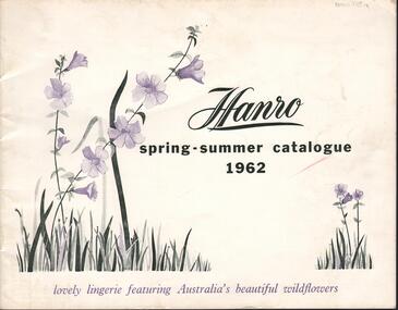
Magazine - HANRO COLLECTION: HANRO SPRING-SUMMER CATALOGUE 1962, 1962
The Hanro company was established in Switzerland in 1884. In 1926 a site in Hargreaves Street Bendigo, behind the School of Mines, was purchased to establish the Bendigo Knitting Mills, a subsidiary of Hanro. The managing director was Charles Handerchin who came from Switzerland. The company was delisted from the Australian Stock Exchange in 1963 when it was taken over by John Brown Industries.Hanro Spring-Summer Catalogue 1962: The cover is of card with a white background and black, green and mauve print. Printed on the cover in black is *Hanro* Spring-Summer Catalogue 1962* To the left is green leaves with mauve wild flowers on two stems and to the right side corner is also green leaves and two stems of mauve wild flowers. Underneath in mauve print is *lovely lingerie featuring Australia's beautiful wildflowers. Inside the cover is advertising the line. Inside the catalogue on white gloss paper are sketches of ladies wearing matching Negligee/Night set, night wear, Pyjamas, Petticoats, Vests Briefs, scanties', Panties, Bed Jackets, half slips, house coats and spencers. Each item has a number, description, size and colour. The back page has advertising. A green paper sheet has been inserted with the retail selling price list with item number size range and price. Over the page has the trade price, item number size etc. On the back cover on a white background is a box with a back border and *Hanro* printed inside along with the Sales Office, address and phone number in each State. Box 116ACambridge Press, Bendigobook, magazine, catalogue, hanro. catalogue. cambridge press, bendigo -
 Bacchus Marsh & District Historical Society
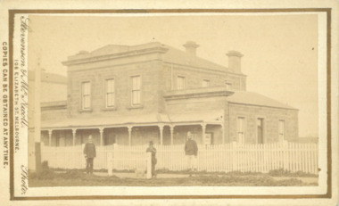
Photograph, Court House Main Street Bacchus Marsh 1883
The Court House in Main Street Bacchus Marsh was built in 1858 using local sandstone. It opened in 1859. It has been used for jury trials, a Court of Petty Sessions, a County Court and a Crown Land sales office. Other uses included an office for the Registrar of Births and Deaths, a Dairy Inspectors office from 1863-1865, and as meeting rooms for the Bacchus Marsh Roads Board, a forerunner of the Shire Council. It was also used by the Bacchus Marsh Shire Council for its offices until at least 1884. In more recent years it has functioned as a Magistrates Court with weekly court sessions. Small sepia unframed photograph on card with gold border framing photograph. Housed in the album, 'Photographs of Bacchus Marsh and District in 1883 by Stevenson and McNicoll'. The view of the Court House building is seen from the northern side of Main Street looking south or south-east. Three men are standing in the street in front of the building. The men on the left and the right wearing police helmets appear to be police officers. The man in the middle is in civilian clothes and might be an officer or employee of the Court House. He has his dog with him. A white picket fence runs along the front of the building. The front courtyard of the building has been renovated since, but this building still operates as a court house.On the front: Stevenson & McNicoll. Photo. 108 Elizabeth St. Melbourne. COPIES CAN BE OBTAINED AT ANY TIME. On the back: LIGHT & TRUTH inscribed on a banner surmounted by a representation of the rising sun. Copies of this Portrait can be had at any time by sending the Name and Post Office Money Order or Stamps for the amount of order to STEVENSON & McNICOLL LATE BENSON & STEVENSON, Photographers. 108 Elizabeth Street, MELBOURNE. stevenson and mcnicoll 1883 photographs of bacchus marsh and district, courthouses, bacchus marsh court house -
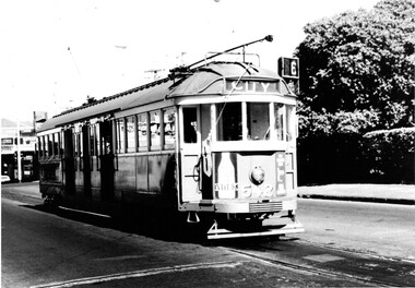
 Melbourne Tram Museum
Photograph - Bourke St from William St looking west - cable trams, c1910
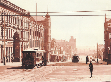
Photograph shows the view from William St looking west along Bourke St. Has two cable tram sets in the view, along with on the south side of Bourke Street the former St. James Building, Gollin & Company Building, then over King Street, Bourke Street West Police Station, McLean Bros. & Rigg Ironmongery & Hardware Store, (later Hudon's Store) and the Tramways Head Office Building. On the northside of Bourke Street is the Massey-Harris Building, John Connell & Co. Pty Ltd "Gresham House" and over King Street, H.V. McKay Harvester's Sunshine Head Office. Also in the distance is the Spencer Street Railway Station buildings. The Archway visible through the St. James Building led into the former Lt. James Street. Yields information about Bourke Street between 1909 and 1913Photograph - sepia toned on A4 sheetHas TMSV Sales stamp on rear.trams, bourke st, william st, cable trams, tramways, tram 402, st. james building -
 Melbourne Tram Museum
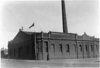
Photograph - Engine House - Abbotsford and Queensberry Sts, Tramway Museum Society of Victoria (TMSV), 1934
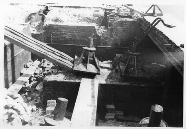
Photograph of of the North Melbourne engine house, or power house or winding house on the corner of Abbotsford St and Queensberry St. Dated 1934 on the rear of the photo. Shows the chimney. This building remains intact other than for the chimney.Yields information about cable trams engine houses.Black & White Photograph - two copies held.Has the TMSV Sales stamp on the rear and a date "Nth Melb Engine House 1934" in pencil on the rear.trams, tramways, cable trams, abbotsford st, engine houses, power house, winding houses, queensberry st -
 Melbourne Tram Museum
Photograph - Black & White Photograph/s, Tramway Museum Society of Victoria (TMSV), c1975
Black & White Photograph by the TMSV Sales of the demolition of winding sheave pit - location not known. Shows the size of the cable pins.Has the TMSV Sales stamp on rear.trams, tramways, cable trams, cable grip, cables, winding houses, tram 565 -
 Melbourne Tram Museum
Photograph - Black & White Photograph/s, Tramway Museum Society of Victoria (TMSV), c1975
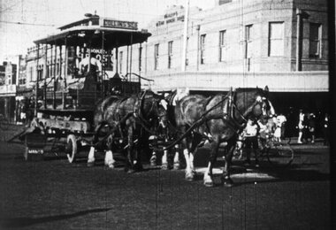
Black & White Photograph by the TMSV Sales of a former grip car being transport on a jinker, pulled by three horses. Photo - Victoria Ave at the corner of Beaconsfield Pde - with the Bleak House Hotel in the background. Advised by Mal Rowe. From an email from Robert Green, 19-08-2021 - advised "The Herald of 10 May 1935, p.4 has the following little paragraph : Cable Tram Tableau Entitled “Transport Cavalcade”: Horse-laughs - real ones – were heard today when a team of horses, drawing a lorry upon which was a dis-used cable tram dummy sporting “Collins Street” upon the front and “South Melb Beach” at the rear, passed along Swanston Street. Neddy’s superiority complex at seeing out these early manifestations of our mechanical age was heightened when the front wheel of a nearby motor-truck fell off." Image has been reproduced from a movie - Commuting by Cable?Has the TMSV Sales stamp on rear.trams, tramways, cable trams, grip tram, beaconsfield parade, albert park -
 Melbourne Tram Museum
Photograph - Set of 5 Black & White Photograph/s, Cable tram operations
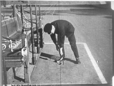
... Tram Cables Winding house Has the TMSV Sales stamp on rear ...1 - employee with a uniform cap - could be a shunter - lifting the cable into the adjacent grip car. Marked on rear as "Lonsdale St" .2 - worker in a cable pulley maintenance pit oiling the mechanism - note the other pits. Has put a "Danger" sing out on the roadway. Marked on rear "Bourke and Spring St 1938" Two copies held and one digital image from a scene shot. .3 - a worker watching the cable entering a winding house looking for damage - what a boring job! Marked on rear as "Checking cables 1938" .4 - communications pillar - or box - to communicate with the winding house .5 - photos shows the grip in the roadway Images have been reproduced from a movie - Commuting by Cable?Yields information of the cable tram operations c1938.Series of five Black & White Photographs by the TMSV Sales and one digital image from Commuting by Cable. Has the TMSV Sales stamp on rear with some notes in pencil on the rear as shown above.trams, tramways, cable trams, grip tram, cables, winding house -
 Melbourne Tram Museum
Photograph - Decorated cable grip or dummy - King George V, 1919
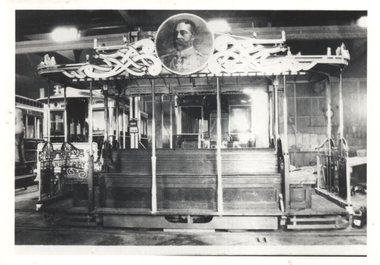
Photo of the dummy or grip car decorated for the Celebration of Peace July 1919. Decorated dummy and car which, electrically illuminated, traversed the Melbourne cable tramways in celebration of peace, on the evenings of Monday and Tuesday, the 14th and 15th July, 1919. Photographed in a car house or depot. Refer to items 4255 and 4256 for further details.Yields information the grip car decorated for the Celebration of Peace.Black and White photograph on plain paper. Second copy has a wider view and plain back.First view has TMSV Sales stamp and note on rear.world war 1, cable trams, celebrations, peace tram, tramway board, grip car -
 Melbourne Tram Museum
Photograph - Black & White Photograph/s, tram W2 542 at the Glen Iris terminus, 1960's
Black and white photograph of tram W2 542 at the Glen Iris terminus, with the destination of City route 6. Has the large hedge of a house and shops in the background. Trams has good appearance, possibly just after a repaint. Has a number of adverts on the front - including one for Milk. Tram at the intersection of Malvern and Darling Roads, Glen Iris. Printed on Fujichrome paper. Not known who took the photograph or when it was printed.Stamped in black ink on back "TMSV Sales"trams, tramways, glen iris, darling rd, route 6, tram 542 -
 Bacchus Marsh & District Historical Society
Map, Plan of the second portion of the property of Messers Atkins and Clarke situate at Bacchus Marsh 1856
... Victoria Maps Bacchus Family Land Sales Manor House Bacchus Marsh ...This plan of land allotments for sale indicates part of the property once owned by the Bacchus family in and around the township area of Bacchus Marsh. The Bacchus family sold their property in Bacchus Marsh to John Aitkins and Robert Nalder Clarke in March 1851. Aitkins and Clarke kept the property for a number of years until April 1856 when these allotments were put up for sale.This is a very early land sales plan for agricultural land close to the township of Bacchus Marsh. It therefore provides some clues as to how the early urban development of the township and agricultural development of the nearby area took place. Upon seeing the map in 1911 Bacchus Marsh Express newspaper editor Christopher Crisp wrote "The sale appears to have created the present township, which had a nucleus in earlier times further east", Express, 30 September, 1911, page 3.A single page paper plan showing allotments of land for sale. The subdivided land shown was owned by John Aitkins and Robert Nalder Clarke, but previously owned by the Bacchus Family and was in and around their Manor House (Mansion) property in Bacchus Marsh. This plan shows allotments in the second portion of land to be sold which was located east of the Manor House on the eastern side of the Lerderderg River. The land for sale was made up of 15 allotments. The plan is pasted into a bound volume containing 76 maps or plans in total. BMDHS Loc: AR/B12/S4 Bacchus Marsh Township and Nearby Districts Maps Volume In-house Digital copies: BMDHS, Computer Network: Maps\Bacchus Marsh Township and Nearby Districts Maps Volumebacchus marsh victoria maps, bacchus family, land sales, manor house bacchus marsh -
 Wodonga & District Historical Society Inc
Decorative object - Sarah Coventry Open Heart Pin
Sarah Coventry Pty. Ltd. was a North American jewellery company that was established in 1949 by the Stuart family as part of Emmons Jewelry, Inc. It began operations in England and Australia in 1968, and in Australia it moved from Carlton in Melbourne to Wodonga in 1969. The premises were originally on High St. in Wodonga, but a new warehouse was built in Melbourne Rd later in 1969. It was a direct selling jewellery business using a party-plan model similar to Tupperware and Avon. The sales reps or 'Hostesses' were provided with jewellery samples in demonstration kits, which they displayed at jewellery parties in their homes. The designs for jewellery such as brooches, necklaces, earrings, chokers and bracelets were purchased from freelance designers and jewellery manufacturers rather than in-house designers. In 1979 Sarah Coventry Pty. Ltd. in Wodonga was bought by three Australian businessmen, including Wodonga local Jim Sawyer, and continued to sell jewellery under the name "Sargem Pty. Ltd”, for several more years in the 1980s. This item was part of the Affinity Jewellery line released in 1982.As part of the Sarah Coventry collection, this item has local significance with the decentralised commercial development of regional centres such as Wodonga in NE Victoria, as well as national and international significance from the perspective of social and economic developments for women after World War II. The direct selling party-plan business model Sarah Coventry was based on is also considered the first of its kind for jewellery.A silver plated stick pin featuring a heart at each end. It is in its original Sarah Coventry box and includes instructions for caring for Sarah Coventry Affinity range items. It is attached to a silver card.On box: SARAH COVENTRY®| AND AFFINITY ® INTERNATIONAL FASHION JEWELLERY On card: Open Heart Imitation Jewellery Sarah Coventry & Affinity International Fashion Jewellery Distributed by Sargem Pty. Ltd. WODONGA VICTORIA Made in USA sarah coventry, sarah coventry affinity, sarah coventry wodonga -
![Map, Millbank Estate Bacchus Marsh Thursday 4th October 1888 [Land sales], 1924](/media/collectors/5e461d8021ea67224c82f2a1/items/67765662eb6d2cbd24e0797f/item-media/67765682eb6d2cbd24e07a41/item-fit-380x285.jpg) Bacchus Marsh & District Historical Society
Bacchus Marsh & District Historical SocietyMap, Millbank Estate Bacchus Marsh Thursday 4th October 1888 [Land sales], 1924
The Millbank Estate was a parcel of land close to the centre of the shopping area of Bacchus Marsh which was sub-divided and offered for sale in 62? lots on the 4th October 1888. The lots had frontages to Ballarat Road (Main Street), Maddingley Road (now Grant Street), Turner Street, Millbank Street, Clarinda Road (now Clarinda Street), and an unnamed street south of Turner Street (possibly known as Grant Street at this time) which connected to Maddingley Road through the vicinity of the present day Bacchus Marsh Hospital. This was a significant sub-division of land and represented a major expansion of residential housing in Bacchus Marsh in the late 19th century. The map includes a wealth of detail about the time of the sale, where it will take place, who the selling agents were, the deposit terms for purchases and details of a special train from Melbourne to Bacchus Marsh on sale day. The location of the allotments in relation to the shopping and commercial area of Bacchus Marsh, Maddingley and the railway station are indicated on an inset map within the overall map and poster. The Millbank Estate area was an area which had once belonged to the Grant family who were prominent early citizens of Bacchus Marsh and lived in a house in this area known as 'Millbank'.This land sale map is a typical example of housing estate land sales advertising maps produced by real estate agents in this era. The map is significant for the detailed information it provides about when and where land was sold for new housing estates in Bacchus Marsh in the late nineteenth century.Single page map showing land allotments for sale at auction in Bacchus Marsh in October 1888. A significant portion of the map is missing from the bottom right side. land sales bacchus marsh, land subdivsion bacchus marsh, housing estates land sales bacchus marsh, grant family bacchus marsh, millbank estate land sales -
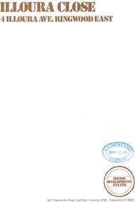 Ringwood and District Historical Society
Document - Sales Brochure, "Illoura Close" 4 Illoura Avenue, Ringwood East, Victoria. Circa 1970s
Folded brochure advertising sale of ten Group Housing Project properties, with list of features, site plan, location map, and typewritten summary of house sizes and prices. Edston Developments Pty. Ltd., 967 Glenhuntly Road Caulfield, Victoria, 3162. Telephone 211 6937. Architects: Clive Fredman and John Malina - 880 Toorak Road, East Hawthorn. Accompanying handwritten notation by Richard Carter R.E.S.I. - "Illoura Close (is) one of the few developments in Ringwood under the Cluster Titles Act". -
 Bacchus Marsh & District Historical Society
Map, Plan of the property of Messers Atkins and Clarke to be sold at the Mansion, Bacchus Marsh 19th April 1856. Copy 1
... Bacchus Family Land Sales Manor House Bacchus Marsh Heading: Plan ...This plan of land allotments for sale indicates the property once owned by the Bacchus family in and around the township area of Bacchus Marsh. The Bacchus family sold their property in Bacchus Marsh to John Atkins and Robert Nalder Clarke in March 1851. Atkins and Clarke kept the property for a number of years until April 1856 when these allotments were put up for sale.This plan is almost identical to another copy held by the Bacchus Marsh and District Historical Society, VC Record 452, BMDHS collection). This plan, VC Record 707 Copy 1, contains a little more detail overall than VC Record 452 Copy 2, such as who did the survey work for the plan (R.C. Bagot) and who the selling agents were, (W.M. Tennent), and on the right side of the plan near the Lerderderg River is indicated the general area for a second parcel of land from this sale which is to be sold. There is also a compass illustration indicating north and south compass points.This is a very early land sales plan for the township of Bacchus Marsh and it therefore provides some clues as to how the early urban development of the township took place. Upon seeing the map in 1911 Bacchus Marsh Express newspaper editor Christopher Crisp wrote "The sale appears to have created the present township, which had a nucleus in earlier times further east", Express, 30 September, 1911, page 3.A single page paper plan showing allotments of land for sale. The subdivided land shown was owned by John Atkins and Robert Nalder Clarke, but previously owned by the Bacchus Family and was in and around their Manor House (Mansion) property in Bacchus Marsh.There are 5 portions of land further divided into numerous small portions. The land for sale is bounded by the present day streets of Main Street, Young Street, McFarland Street, Morton Streets, Crook Street, and part of the eastern section extends to the Lerderderg River. Scale: 8 chains to 1 inch The plan is pasted into a bound volume containing 76 maps or plans in total. BMDHS Loc: AR/B12/S4 Bacchus Marsh Township and Nearby Districts Maps Volume In-house Digital copies: BMDHS, Computer Network: Maps\Bacchus Marsh Township and Nearby Districts Maps VolumeHeading: Plan of the first portion of land. The property of Messers Atkins and Clarke situate at Bacchus Marsh. To be sold by W.M. Tennent & Co. at the Mansion on the Ground on Saturday the 19th April 1856. Below heading: Jas Ferguson, Lithographer On upper right side: Subdivided by R.C. Bagot London and Liverpool Chambers, Melbourne. 'Thos Taubman'. Post Office Stamp: BACCHUS MARSH VICTORIA MY 6, 63bacchus marsh victoria maps, bacchus family, land sales, manor house bacchus marsh -
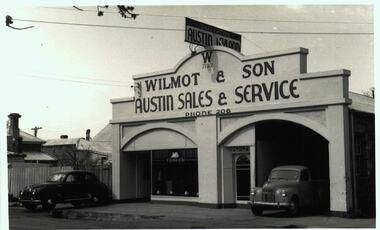 Bacchus Marsh & District Historical Society
Photograph, Wilmot and Son Austin Sales and Service Main Street Bacchus Marsh
This building, located at 97 Main Street Bacchus Marsh, was built by Mr George Muir in 1920 using bluestone walls from Landsberg House, a former boarding school at Mt. Blackwood. In 1946 Mr W. J. Wilmot opened a car sales business which was sold in 1954 to trade as Stamford Motors. Subsequently, various businesses operated on this site, and is still in use, presently as an accountancy business.Black and white photographic print. Photograph dates from the 1940s and shows a bluestone building with lintels of local sandstone supporting a pediment with a sign advertising Austin cars fixed on top. Signage on the pediment reads: W 1930 WILMOT & SON AUSTIN SALES & SERVICE PHONE 206. The frontage is divided in two, both sections topped by an arch. The left-hand section is glass-fronted, the right section open for vehicle access. The door between the two sections is also arched. Two vehicles are parked at the front, a sedan and a ute, presumably both Austins. The bluestone building materials are visible at the side.shops bacchus marsh vic., main street bacchus marsh vic., garages, landsberg house, w j wilmot -
 Ringwood and District Historical Society
Document - Folder, Proposed Auction - Wellwood Cottage, Glenvale Road, Ringwood - 1955
Folder containing auction advertisements and incomplete copies of Certificate of Sale from an abortive November 1955 auction of "Wellwood Cottage" Elizabethan style residence under instructions from Keith Wellwood Storey. Newspaper auction clippings from Melbourne Age and Argus issues during November 1955 attached to folder. Packet of family photographs circa 1950s featuring exterior and interior views of the residence and grounds including 2 with captions - "... Rosemary putting food out for birds ..." and "Wellwood Cottage taken in snow in July '51 from Glenvale Road". Property description: "Elizabethan type residence in brick and timber of 2 storeys and attic, containing lounge, dining room, kitchen, living room, study, 3 bedrooms, 2 attic rooms, garage, large workshops. Childrens' 2 storey play house, tennis court, barbecues, etc. Elec. H.W.S., septic sewerage. This desirable and unique property is situated in 5 acres of land, including garden of ornamental shrubs and pine plantation. High position approximately 1-1/2 miles from Ringwood Station. Vacant Possession. Terms 10% deposit, balance 60 days. Inspection 2-4p.m. Saturdays, or by appointment with the Auctioneer, C.E. Carter & Son, 126 Whitehorse Road, Ringwood, WU6024." Accompanying handwritten sales notes researched in 2024 by Richard Carter - Carter Real Estate - "Property did not sell then, but was later sold to Bethunes. House demolished circa 2020". -
 Ringwood and District Historical Society
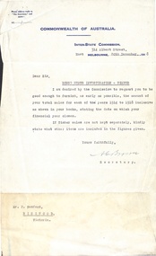
Document, Bamford Bros Ringwood - Letter from Commonwealth of Australia Inter-State Commission and Bamford Reply December 1918
Typed Letter from Inter-State Commission (COmmonwealth of Australia) re House Rents Investifation (Timber), requesting total sales figures for each year 1914 to 1918. Handwritten reply from P.Bamford on Bamford Letterhead listing sales figures. Figures for 1914-1918 are listed under Bamford Bros Ringwood. Following the 1918 entry (from 1st July 1917 to 2nd Feb 1918)is a note "Bamford Bros sold their business", followed by a single entry under the P. Bamford with the figure from 2nd Feb to June 30th 1918. Note Letterhead has address as White Horse Road Ringwood, phone No. 3 Ringwood. -
 Linton and District Historical Society Inc
Conveyance document, Conveyance document, 1863 : sale of Allotment 15, Section 1, Township of Linton : Henry Franks to William Hugill
The land (with improvements) was sold for £650. Henry Franks had purchased the land for £16.15s at the Sale of Special Lands at Linton in 1861. The land, on the corner of Sussex and Clyde Streets, Linton, was later owned by David McFadzean, and after his death by several generations of the Barr/Greenbank families. It is understood that David McFadzean built the house there in 1873. (House still standing, generally referred to as "Barr's" - current address 64 Sussex Street, Linton.)A3 photocopy of an agreement ("indenture") made in 1863 between Henry Franks and William Hugill for the sale/purchase of Allotment 15, Section 1, Township of Linton. henry franks, william hugill, conveyance documents, land sales, land purchases, j. h. barr, david mcfadzean, allotment 15 section 1 township of linton, 64 sussex street linton