Showing 6428 items matching "housing"
-
 Ringwood and District Historical Society
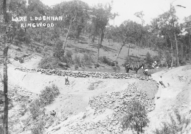
Photograph, Building the recreational man-made lake on the north side of Loughnans Hill: "Lake Loughnan". (Undated)
Printed on photo "Lake Loughnan Ringwood"Typed below photograph, "Building the recreational man-made lake on the north side of Loughnans Hill. It was the local swimming hole in Werac Drive gully beyond Kubis Drive. Now site of a new housing estate." Written on Photo "Lake Loughnan Ringwood" -
 Ringwood and District Historical Society
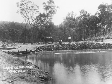
Photograph, Building the recreational man-made lake on the north side of Loughnans Hill
Typed below photograph, "Building the recreational man-made lake on the north side of Loughnans Hill. It was the local swimming hole in Werac Drive gully beyond Kubis Drive. Now site of a new housing estate". Written on photo: Lake Loughnan Ringwood -
 Greensborough Historical Society
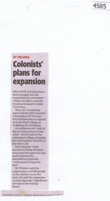
Newspaper Clipping, Diamond Valley Leader, Colonists' plans for expansion, 14/06/2017
Millions of dollars have been pumped into the expansion of the Leith Park retirement village in a bid to ease the housing demand for older VictoriansNews article 1 pages, black text.old colonists, leith park -
 Flagstaff Hill Maritime Museum and Village
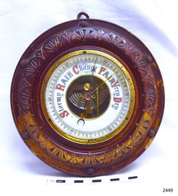
Instrument - Barometer, Early 20th century
A barometer is an instrument used for measuring atmosphere pressure thus determining weather changes.The first apparatus generally accepted as a barometer was that set up in Florence in 1644 by Evangelista Torricelli (1608–1647), a mathematician and physicist. Torricelli filled a glass tube with mercury, sealed it at one end, and inverted it with its open end in a dish of mercury. The level always fell a short way down the tube, then settled at a height of about thirty inches. He concluded correctly that the mercury column was sustained by the weight of the air pressing on the open surface of mercury, and further experiments convinced him that the space above the mercury in the tube was a vacuum. He noted that the level rose and fell with changing temperature, but he was unable to use his apparatus to measure variations in the weight of the atmosphere because he had not foreseen that temperature would affect the level of the mercury. News of this experiment circulated quickly among European scientists, who hastened to replicate the experiment. Torricelli's conclusions were not universally accepted because some disputed whether the air had weight, while both Aristotle and the Catholic Church denied the possibility of a vacuum. In France, the philosopher René Descartes (1596–1650) seems to have been the first person, probably in 1647, to attach a graduated scale to the tube so that he could record any changes attributable to the weather. At around this time Duke Ferdinand II of Tuscany organized the first short-lived meteorological network among scientists in other Italian cities, gathering observations of pressure, temperature, humidity, wind direction, and state of the sky.Theis barometer is an example of a household item from the early 20th century, used to determine the day's weather. The barometer is significant as an aid to human social, material and scientific development.Barometer, round, brass housing inset into carved wooden casing (lacquer mostly worn off). Decorative lettering for weather conditions "Stormy, Rain, Change, Fair, Very Dry". Workings are visible through opening in centre of dial. Indicator needle and another adjustable needle . Hook screwed into back of case.flagstaff hill, warrnambool, shipwrecked coast, flagstaff hill maritime museum, maritime museum, shipwreck coast, flagstaff hill maritime village, great ocean road, barometer, scientific instrument, weather forcasting instrument, weather gauge -
 Kiewa Valley Historical Society
Slicer Bean, early 1900's
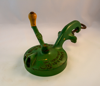
This large bean slicer was first manufactured in the late 1800's in England and exported to Australia. Due to the transportation costs it was not used in many Domestic kitchens. This slicer would have been in a kitchen of a higher socio/economic family within the Kiewa Valley. In the 1930's the manufacturer traded this slicer as "domestic labour-saving slicers". This was the beginning of new generation of the kitchen "gadget". The introduction of the Asian "gadget" manufacturer from the late 1950's saw English export diminish by the cheaper Asian products.This item has great significance because it demonstrates that even "remote rural" locations, such as the Kiewa Valley in the early 1900s still were able to optain "state of the art" labour saving "kitchen" appliances. It was these English and European goods that were made "to last" which brought the mind set "British is best" This mindset was only altered by periods of Australian economic down turns and the cheap Asian product availabilityThis bean slicer is made from cast iron with a round body housing three rotating blades screwed into a riveted spinning base plate. The whole body of this slicer is green with a "natural coloured" handle. A "G" clamp is part of the main frame to fasten the slicer onto a table/counter top (when in use). On the side of the handle and along the top plate "SPONG & Co Ltd" and opposite "BEAN SLICER" below this "No 633"domestic kitchen time savers, food processors, bean slicers -
 Port Melbourne Historical & Preservation Society
Photograph - Aerial view of 3 liners at Station Pier, Port Melbourne, 14 Feb 2001
Large colour aerial photograph of 3 liners at Station Pier. Siver Cloud - outer East; QE2 - outer West; Regal Princess - inner West. View of Port Melbourne housing and foreshore development. Women's Welcome (or band) Rotunda on left of photo. Also a newspaper copy of the photo. COPYRIGHT RESTRICTEDmaritime, piers and wharves - station pier, transport - shipping, queen elizabeth ii, regal princess, silver cloud, beacon cove, swallow & ariell ltd, band rotunda -
 National Vietnam Veterans Museum (NVVM)
Photograph, Gibbons, Denis, 7 RAR Fire Support Base
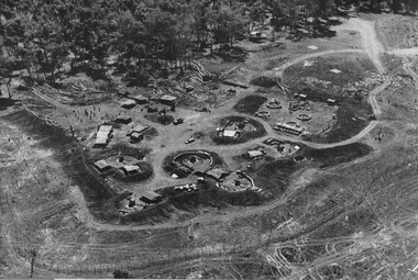
Denis Gibbons (1937 – 2011) Trained with the Australian Army, before travelling to Vietnam in January 1966, Denis stayed with the 1st Australian Task Force in Nui Dat working as a photographer. For almost five years Gibbons toured with nine Australian infantry battalions, posting compelling war images from within many combat zones before being flown out in late November 1970 after sustaining injuries. The images held within the National Vietnam Veterans Museum make up the Gibbons Collection. A black and white photograph of an oblique view of 7 RAR Fire Support Base, housing the Battalions direct artillery support, 106 Battery. The FSB also contained the Battalion's mortar platoon. The guns and mortars were 'on the open' and the Battalion elements can be seen, under cover, in the 'scrub'. (Circa May 1970)photograph, 7 rar, fire support base, 106 field battery, gibbons collection catalogue, denis gibbons, photographer, vietnam war, artillery support, mortor platoon -
 Surrey Hills Historical Society Collection
Book, The Orchards of Doncaster & Templestowe
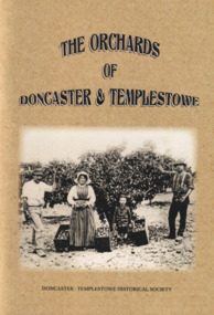
For 100 years Doncaster-Templestowe was a major fruit producing area. The industry had a profound effect on the landscape and vegetation. Although orcharding families came from a variety of backgrounds, German families were an important sub-group.A comprehensive history of fruit growing in the Doncaster-Templestowe area between 1850s and 1950s when orchards began to be subdivided for housing. It includes B&W photos and line drawings and maps. It covers details of the varieties grown, the families involved, pests, machinery involved, markets, blacksmiths and reasons for the demise of the industry in the area.irvine green, eric collyer, doncaster-templestowe historical society, gottlieb thiele, ruffey creek, bismarck street, victoria street, thomas petty, george hislop, john whitten, john clay, august aumann, carl hanke, gottfried uebergang, waldau, max schramm, german lane, george street, john tully, henry crouch, george tortice, august zerbe, jane serpell, sidney williams, phylloxera, joseph bosisto, richard serpell, frederick thiele, w s williams, edwin lawford, james read, john finger, richard clay, ferdinand finger, leeds street, wetherby road, john russell, sarah uebergang, mary hislop, rudolph werner, john petty, archibald mclaren, john hicks, joe hicks, john smedley, william smedley, william hunter, sylvester mullens, laurie's forge, curtis hillman, anne hillman, dan harvey, calder's forge, hillman's blacksmith works, thomas serpell, gill smith, victorian fruit growers association, h g reynolds, alfred thiele, william webb, fred zerbe, mary anne clay, orchardist's coolstore, r h werner & co, j h land, orchardists and fruit cool stores association, a t petty, r read, r chivers, jack noonan, arthur ireland, jack robinson, george knee, donvale cool store, herb petty, frank petty, fred tolly, gordon white, blue moon fruit co-operative ltd, kathleen petty, peg chivers, jack russell, mathew adams, george mcgahy, edwin bullock, james hodson, edwin wilson, david corbett, edwin lowford, thomas beavis, william hanke, tom petty, edward crossman, andrew zander, carl aumann, heinrich fromhold, thomas chivers, william williams, reinhold denhert, henry finger, august furhmann, henry serpell, john ireland, frank smedley, william kent, william knee, thomas buck, henry white, gottlieb leber, alexander speers -
 Geoffrey Kaye Museum of Anaesthetic History
Equipment - Inhaler, Probyn Williams, c. 1900
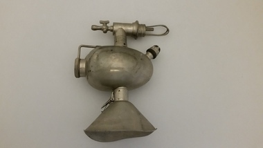
In 1896 Robert James Probyn-Williams was appointed first honorary anaesthetist to the London Hospital and joined a select band of fulltime anaesthetists (26) in Great Britain. The Probyn Williams inhaler was a further modification of the Clover inhaler with narrow airways and rebreathing. The metal inhaler is ovoid shaped. The rotating gauge has a series of numbers engraved onto the inhaler for measurement. There is an elbow joint leading to a connector for attaching a re-breather bag, and at the other end is tap-style mechanism. There is a small glass bulb encased in a metal housing. The facemask is completely made of metal as well.Stamped into handle of tap: COEXTER & SONjoseph clover, frederick hewitt, robert probyn williams -
City of Kingston
Photograph - Colour, 1993
Carrum is a suburb in the City of Kingston bordered by the Patterson River in the north and Kananook Creek in the south. To the east the suburb is adjacent to Patterson Lakes. The Carrum Station was opened in 1882, when the railway line from Mordialloc was extended to Frankston. In the early 20th century, it was a destination for holidaymakers occupying tents and cabins. The area now consists of older housing and over time there have been many new housing developments.Carrum is located in the area that was originally part of the Carrum Carrum Swamp. The district had originally been the home of the Bunerong people who fished, gathered food and found refuge in the sand dunes. The Swamp was drained in 1879 when the Patterson Cut was formed and became known as Patterson River. Apart from local farmers, fishermen and hotel-keepers, there were few permanent residents until the early 20th century when it had become popular as a beach resort. In the 1920s and 1930s the area became occupied by more permanent residents.Laminated aerial colour photograph of Carrum and Patterson Lakes in the City of Kingston. The photograph also includes Kananook Creek and the northern section of Seaford. Prominent features include Roy Dore Reserve, Carrum Primary School, Patterson River Secondary College, Keast Park Seaford, the Seaford Swamp Drain and a section of Downs Estate situated on the traditional lands of the Bunurong people.Black type on white adhesive sticker: No. 7140 Black type of white adhesive sticker: 31-1-93 Black handwritten ink (marker): * [an asterisk] Yellow circular adhesive stickerpatterson lakes, seaford, carrum carrum swamp -
 Robin Boyd Foundation
Document - Manuscript, Robin Boyd, Habitat 67, 1967
Boyd discusses the achievement of Moshe Safdie in the design and dream of Habitat 67. He outlines the history, philosophy and sociological objective of cluster housing.Original manuscript published as 'Experimenting with boxes: Habitat's cluster' in Architectural Forum Vol.126, No.4, May 1967 pp. 35-41.Typewritten (p/copy), quarto, 9 pageshabitat 67, moshe safdie, expo 67, le corbusier, urbanism, unite d'habitation, reyner banham, alison and peter smithson, kenzo tange, clusters, russian apartments, cluster housing, robin boyd, manuscript -
 Stawell Historical Society Inc
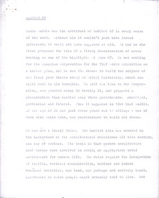
Photograph, Christ Church of England Stawell c1890
Brick Christ Church of England built on a site granted 1862 on Church Hill. Completed in 1863 and demolished in later years and replaced by housing. 4 photographs of brick church in bush settings.0001 Church of England Stawell West 0001-2 Thur. 29 Feb 1940 in Sun Paper of Fri.12 Jan 1940 page 21 Mr. & Mrs. Edward Stephens was married in the church of England Stawell on 11th Jan 1867 now used as a boys Scout Hall.stawell building religion -
 Bendigo Military Museum
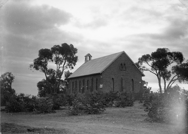
Accessory - FLYING GLASSES
Original flying spectacles worn by Flight Lieutenant Ian A. Lyons. Part of the Flight Lieutenant Ian A. 'Joe' Lyons MBE Collection. See Catalogue No. 5374P for his service record..1) Blue metal spectacles case with silver coloured metal hinges and clasp. Lined with blue velvet fabric. .2) Fabric covered metal frame for housing spectacles within the outer case - .1). .3) Metal framed aviator style spectacles with dark green lens. Clear plastic nose pieces..1) Stamped on top and bottom of case: 'SPECTACLES MKII. 22C/1370. LARGE, (upwards arrow).accessories, flying spectacles, flight lieutenant ian a. lyons -
 Port Melbourne Historical & Preservation Society
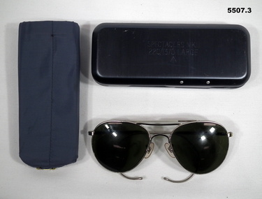
Photograph - Corner Nott and Farrell Streets, Port Melbourne, 1970 - 1979
Photographic images of properties in Port Melbourne. Image may have been taken by a PMHPS member or scanned from a past resident or taken for real estate sale purposes. Corner Nott and Farrell Streets Two images ; 1970s prior to redevelopment of unusual octagonal building; 2012 after redevelopment of public housingbuilt environment - domestic, nott street, farrell street -
 Bendigo Historical Society Inc.
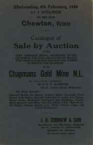
Document - IAN DYETT COLLECTION: AUCTION CATALOGUE - CHAPMAN'S GOLD MINE
Darkish blue catalogue for an auction sale at the Chapmans Gold Mine N. L. at Chewton, Vic. On 8 February, 1939 by Order of the Liquidator, Mr. D. R. S. McGregor. For sale was Mining Machinery, Plant, Equipment, Tools,Corrugated Iron Housing and Buildings. J. H. Curnow & Son were the auctioneers.business, auctioneers, j h curnow & son pty ltd, ian dyett collection - auction catalogue - chapmans gold mine n. l., d r s mcgregor, j h curnow & son, old quartz hill mine, albion hotel (near chewton), roberts & son, the cambridge press -
 Bendigo Historical Society Inc.
Document - MERLE HALL COLLECTION: ''HOUSING THE ARTS'' AUSTRALIA COUNCIL
''Housing the Arts - Establishing Community Arts Centres or Performing Arts Facilities'' Australia Council 1979. 22 page booklet - Synopsis of a survey and report on 30 community arts centres and civic centres in Australia - with brief descriptions of facility and photograph. Introduction of a Resource Kit for Local Councils and arts organizations. (2 copies). -
 Ballarat Tramway Museum
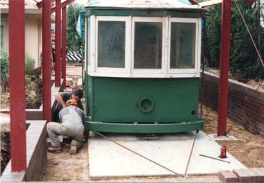
Photograph - Geelong trams 2 and 28, 2004
The set of three colour prints shows various stages housing Geelong trams 2 and 28 by their donor when he was living in Canberra. 1 - tram 2 being winched into position with the frame of the shed to house them being built - 20/6/1991 2 - Temporary truck for Geelong 2 before unloaded - 25/5/2004 3 - Showing the "shed" housing the two trams - 26/5/2004.Yields information the reconstruction of two Geelong trams in Canberra before being gifted to the BTM.Set of three colour prints on Kodak paper with dates on rear.Two have the date and details on rear.tramcars, tram 28, geelong 2, geelong 28, tram 2 -
 Ringwood and District Historical Society
Pamphlet, Council of Borough of Ringwood - Alfred Kelly, Town Clerk and Treasurer, Ringwood Council's Annual Report To The Ratepayers (January 1959), 1959
Borough of Ringwood community information report for 1958 issued January 1959, including submission by Council for Victorian Premier Town Contest 1958. Other sections cover Town Planning, Culture and Education, Community Self-help, Town Promotion, Town Beautification, Housing, Tourism, Fire Hazards, Dog Nuisance, and Rates and Charges."... While Ringwood was not adjudged the Premier Town among the 43 entries, it was complimented for the manner in which the case was presented ...".rinx -
 Maldon Vintage Machinery Museum Inc
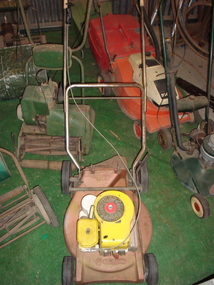
Motor Mower, c1970's
Rotary mower made by "MASPORT", orange with yellow and white engine housing. 4 rubber tyred plastic wheels, 2 large on back & 2 small on front. Pull start, single bar rotary cutter. Chrome plated folding handle with white plastic horizontal cover at top. Hinged safety flap at rear.Cast into base "M MASPORT". The M has a circle around it.machinery, motor mower, rotary -
Maldon Vintage Machinery Museum Inc
Clock
Battery operated clock with a highly lacquered face with an image of half of a split casing pump casing. The image is in blue and black on a white ground centred on a circular wooden clock face. Numbers are imitation chrome plastic covered with lacquer. The second hand is red. The backing board is rectangular. The operating mechanism is centred in a housing on the back.Maker's name ("Chris Shaw") on a gold sticker at the bottom centre of the back.horology -
 Eltham District Historical Society Inc
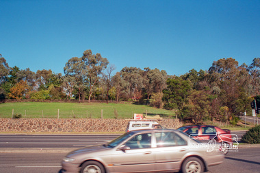
Photograph, Fitzsimons Lane Reserve bounded by Main Road, Bolton Street and Fitzsimons Lane, Eltham, c.May 2001
Viewed from Main Road just east of Bolton Street, approaching Fitzsimons Lane roundabout. Now partially developed as the Monarch Ridge housing estateRoll of 35mm colour negative film, 7 stripsAgfa HDC 200 plus-2eltham, streets, main road, fitzsimons lane reserve, houses, monarch ridge estate -
 Eltham District Historical Society Inc
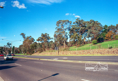
Photograph, Fitzsimons Lane Reserve bounded by Main Road, Bolton Street and Fitzsimons Lane, Eltham, c.May 2001
Viewed from Main Road just east of Bolton Street, approaching Fitzsimons Lane roundabout. Now partially developed as the Monarch Ridge housing estateRoll of 35mm colour negative film, 7 stripsAgfa HDC 200 plus-2eltham, streets, main road, fitzsimons lane reserve, houses, monarch ridge estate -
 Eltham District Historical Society Inc
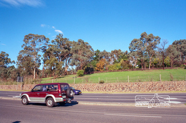
Photograph, Fitzsimons Lane Reserve bounded by Main Road, Bolton Street and Fitzsimons Lane, Eltham, c.May 2001
Viewed from Main Road just east of Bolton Street, approaching Fitzsimons Lane roundabout. Now partially developed as the Monarch Ridge housing estateRoll of 35mm colour negative film, 7 stripsAgfa HDC 200 plus-2eltham, streets, main road, fitzsimons lane reserve, houses, monarch ridge estate -
 Port Melbourne Historical & Preservation Society
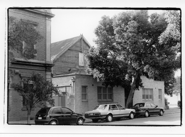
Photograph - Princes Street exterior, Excelsior Hall, Port Melbourne, Gary Spivak, 2000
Taken by Gary Spivak, an officer of the City of Port Phillip involved with the reconstruction of heritage buildings to create low cost housing. this project was under his direction.B&W photos of Excelsior Hall 2003, prior to redevelopment into units 10 - Princes St view from southbuilt environment - civic, town planning, heritage, excelsior hall, rsl, returned services league -
 Port Melbourne Historical & Preservation Society
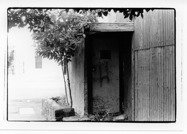
Photograph - Back entrance, Excelsior Hall, Port Melbourne, Gary Spivak, 2000
Taken by Gary Spivak, an officer of the City of Port Phillip involved with the reconstruction of heritage buildings to create low cost housing. this project was under his direction.B&W photos of Excelsior Hall 2003, prior to redevelopment into units 01 - Back entrancebuilt environment - civic, town planning, heritage, excelsior hall, rsl, returned services league -
 Port Melbourne Historical & Preservation Society
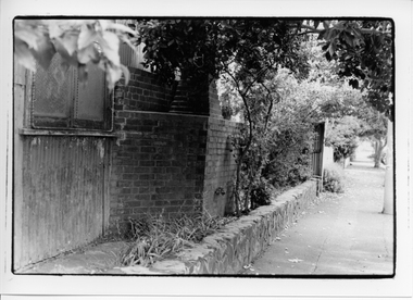
Photograph - Chimney in Station Street, Excelsior Hall, Port Melbourne, Gary Spivak, 2000
Taken by Gary Spivak, an officer of the City of Port Phillip involved with the reconstruction of heritage buildings to create low cost housing. this project was under his direction.B&W photos of Excelsior Hall 2003, prior to redevelopment into units 02 - Chimney in Station Stbuilt environment - civic, town planning, heritage, excelsior hall, rsl, returned services league -
 Port Melbourne Historical & Preservation Society
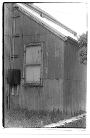
Photograph - Window in extension, Excelsior Hall, Port Melbourne, Gary Spivak, 2000
Taken by Gary Spivak, an officer of the City of Port Phillip involved with the reconstruction of heritage buildings to create low cost housing. This project was under his direction.B&W photos of Excelsior Hall 2003, prior to redevelopment into units .03 - Window in extensionbuilt environment - civic, town planning, heritage, excelsior hall, rsl, returned services league -
 Port Melbourne Historical & Preservation Society
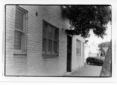
Photograph - Front door, Excelsior Hall, Port Melbourne, Gary Spivak, 2000
Taken by Gary Spivak, an officer of the City of Port Phillip involved with the reconstruction of heritage buildings to create low cost housing. this project was under his direction. B&W photos of Excelsior Hall 2003, prior to redevelopment into units 04 - Front doorbuilt environment - civic, town planning, heritage, excelsior hall, rsl, returned services league -
 Port Melbourne Historical & Preservation Society
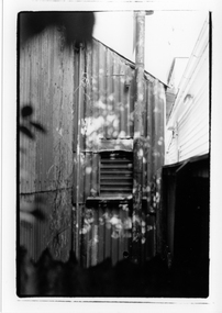
Photograph - Louvre windows, Excelsior Hall, Port Melbourne, Gary Spivak, 2000
Taken by Gary Spivak, an officer of the City of Port Phillip involved with the reconstruction of heritage buildings to create low cost housing. this project was under his direction.B&W photos of Excelsior Hall 2003, prior to redevelopment into units 05 - Louvre windowsbuilt environment - civic, town planning, heritage, excelsior hall, rsl, returned services league -
 Port Melbourne Historical & Preservation Society
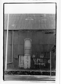
Photograph - No Nukes Graffiti, Excelsior Hall, Port Melbourne, Gary Spivak, 2000
Taken by Gary Spivak, an officer of the City of Port Phillip involved with the reconstruction of heritage buildings to create low cost housing. this project was under his direction.B&W photos of Excelsior Hall 2003, prior to redevelopment into units 06 - "No Nukes" graffitibuilt environment - civic, town planning, heritage, excelsior hall, rsl, returned services league