Showing 1672 items
matching no 55
-
 Bendigo Historical Society Inc.
Newspaper - JENNY FOLEY COLLECTION: GOLDEN DAYS
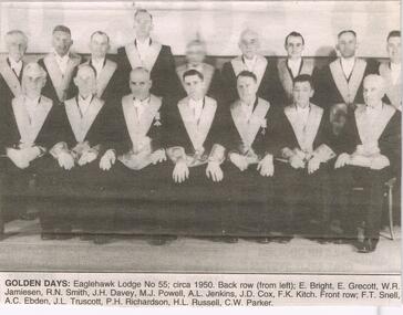
Bendigo Advertiser '' the way we were'' from Monday, November 25, 2002. Golden days: Eaglehawk Lodge No. 55; circa 1950. Back row from left: E. Bright, E. Grecott, W. R. Jamiesen, R. N. Smith, J. H. Davey, M. J. Powell, A. L. Jenkins, J. D. Cox, F. K. Kitch. Front row F. T. Snell, A. C. Ebden, J. L. Truscott, P. H. Richardson, H. L. Russell, C. W. Parker. The clip is in a folder.newspaper, bendigo advertiser, the way we were -
 Bendigo Historical Society Inc.
Document - H. A. & S. R. WILKINSON COLLECTION: CONTRACT OF SALE
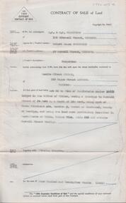
Contract of sale of land dated 9th February 1955 between Mr. R. J. Sanderson (vendor) and Mr. L. A. Pitson (purchaser). Property: Lot 55 on plan of subdivision No. 16998 lodged in the office of titles, having a frontage to Burrell Street of 50 feet by a depth of 140 feet, being part of Crown allotment 432 section H Parish of Sandhurst County of Bendigo, land described in certificate of title volume 7314 folio 636 and situate Burrell Street, Bendigo, together with the fencing thereon. Price: 425 pounds.organization, business, h.a. & s.r wilkinson real estate -
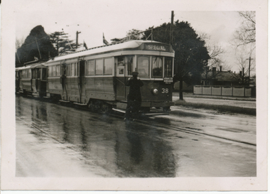
 Ballarat Tramway Museum
Photograph - Black & White Photograph/s, mid 1920's
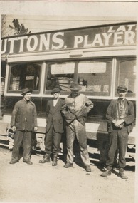
Black and white photograph contained within Reg. Item 2488, page 55, of four ESCo workers standing by an ESCo tram at the depot. Handwritten caption by H.P. James identifies the people as N. Edwards, Chris Hodgson (foreman), Tom Duke and "old" Bob Tryaskos. See Inscriptions for details about the advertisements in the tram window. Has part of the Suttons roof advertisement. Note Item Not formally Numbered. Image btm2507i2 shows position on page relative to items 2507 to 2512. High Res Images added 15/3/2011. Handwritten in Pencil under the photograph is "4 employees at Depot "N. Edwards, Chris Hodgson (foreman), Tom Duke and old Bob Tryaskos advertisements was a strong feature. The cars you see hanging in the window are Picture Show programmes either of Her Majesty's (Saturday and Wednesday) Pathes Alfred Hall also used this plan." Note the word "Coliseum" had been crossed out.tramways, trams, depot, suttons, esco, employees -
 Ballarat Tramway Museum
Photograph - Black & White Photograph/s, late 1920's
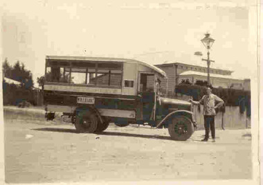
Yields information about a vehicle the Electric Supply Co of Victoria used to provide additional services in Ballarat in the face of bus competition. See page 59 of Golden City and its Tramways for further information.Black and white photograph contained within Reg. Item 2488, page 55, of ESCo or Ballarat Tramways motor bus, with the destination of Mt. Pleasant on the side. Driver W. Irwin? Handwritten caption by H.P. James. Note Item Not formally Numbered. Image btm2507i2 shows position on page relative to items 2507 to 2512. For a copy photograph of this image, see Reg Item 3813. High Res Images added 15/3/2011. Digital scan of a negative in the Wal Jack Collection added 21/4/2019 as image btm2510i4Handwritten in Pencil under the photograph is "Here is an interesting picture. Note the driver he is W. Irwin who gave me these pictures for which I am very grateful. The bus petrol engine International type was formerly in the possession of, one, Cruickshanks, an independent driver with a permit from the council to run between The Point of Pictures?, Ness St, Mt Pleasant via Bond St, Peel St. to City but the Electric Supply Coy purchased the vehicle and ran it from 1927 to 1929 (unpayable). The most use it was put to was on Mt Pleasant, but it ran also to High School as replacement for trams on Sebas if an electric tram was derailed. Perhaps the most unique trips it ever made was between Forest St. Wendouree to the Aerodrome, 1929, on the occasions of any ?? flight. Again Mr Irwin was the driver (& made two trips)"tramways, trams, esco, motor buses, mt pleasant, cruickshanks -
 University of Melbourne, Burnley Campus Archives
Album - Black and white prints and roll of negatives, James Leslie Provan, Burnley 1942 Album, 1942-1943
2 pages of a photograph album with small black and white photographs pasted on both sides of the cardboard page, some labelled. Includes roll of negatives in a metal and cardboard container. Page 1A: 1-36 "Burnley - Feb-Apr 1942", 37-55 "June '42", 56-62 "Sept '42." Page 2B: 1-27 "Sept '42 (cont)." 28-53 "Feb 43". These photographs are identical with many of those in B09.0005, but smaller. Therefore probably this is also J.L. Provan's album. See B09.0005 also for slides of these photos.negatives labelled, "Burnley Sept. '42 Positive," "2," and "140."burnley, 1942, j.l. provan, orchard, garden views, nursery, students working outside, hilda kirkhope rockery, vegetables, pavilion, luffmann ponds, entrance, lagoon paddock, poultry, cows, dairy, principals residence, old nursery, horses, milking shed, silo, swan street entrance, lily ponds, jersey calves -
 Melbourne Tram Museum
Photograph - Black & White Photograph/s, Bob Prentice, c1910
Black and white photograph of PMTT No. 4 at the Burke Road terminus with Central Park in the background. Has the driver and conductor in the view along a family of a lady and some children. Also a dog in the photograph. Tram has the destination of Burke Road on the roof and Prahran on the rear. Note the coupling arrangement at the front of the tram. Photograph features on page 55 of Ian Brady's book on the PMTT, "Melbourne's Foremost Municipal Tramway". Photograph from the Bob Prentice Collection. Has remnants of a handwritten note on the rear - has been removed from sheet with remains of the sheet on the rear.trams, tramways, pmtt, burke rd, prahran, drivers, conductors, tram 4 -
 Falls Creek Historical Society
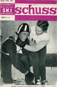
Journal - Schuss Vol. 27. No 2 March - April 1961
Schuss was advertised as Victoria’s Official Ski Journal It was issued monthly from 1935 to 1961 except during the war when summer issues covered two months. This continued after the war, but it averaged 10 issues annually over its 25 year life. Schuss was published by the Ski Club of Victoria which had a membership of 38 Ski Clubs and demanded to be recognised as the prime authority on skiing in the state. The other 30 ski clubs with 85% of the members disagreed and the politics of skiing became heated. These clubs formed the Federation of Victorian Ski Clubs with their own journal, Ski Horizon. With the establishment of the Victorian Ski Association, Ski-Horizon published its last issue in Nov - Dec. 1955 and the role of the official journal was fully taken over by “Schuss”. This item is significant because it contains stories, images and information documenting the development of the ski facilities at Falls Creek.This was the Final Issue of Schuss. The cover featured a photo of Marie Davis (Downhill Winner) helping Rickie Laycock (Slalom Winner) with his crash helmet before the start of the 1960 intermediate championships. An article on Page 53 explained whilst this was the final issue of Schuss, the initial issue of SKI Australia incorporating "Schuss" was going to press and was expected to be available in the last week of April. Page 55 reported on progress on new facilities at Falls Creek whilst pages 65 - 67 featured an extensive article "Training for Cross-Country" written by Dick Walpole.schuss journal, siggi haberzetti, dick walpole, , ski australia journal -
 Melbourne Tram Museum
Album - Robert Thomson Slide Collection, "13.11.2001 to 19.11.2001 October 2003 512-537"
Photo - see pdf file for further information. Number Brief Description RT149 Docklands - track work RT150 "2" track work at Glenferrie Rd RT151 Box Hill terminus - tram 3029 - "Port Melbourne" route 109 - at Elgar Rd stop RT152 Docklands RT153 East Brighton terminus - tram 112 - "University" - route 64 RT154 "4" - track work excavators at Malvern & Glenferrie Rds RT155 Box Hill terminus - tram 3035 - "via City" route 109 RT156 Docklands - track work RT157 "1" New Junction Malvern - Glenferrie RT158 "3" track work at Malvern & Glenferrie Rds RT159 Docklands - La Trobe St - tram 2073 - "Bundoora RMIT" - route 86 & tram 2003 - "Bundoora RMIT" - route 86 RT160 Docklands RT161 Docklands - Collins St extension RT162 Docklands - track work RT163 Collins St -tram 124 - "West Preston" - route 112 - at Town Hall stop RT164 Port Melb terminus - tram 278 - "Mont Albert" - route 109 RT165 Swanston St - tram 67 - "University" - route 6 RT166 Port Melb terminus - "Mont Albert" - route 109 RT167 Camberwell Depot - tram 971 - "City" - route 55, tram 881 - "Camberwell" RT168 Victoria Pde - tram 3004 -"Mont Albert" - route 109 RT169 Victoria Pde - tram 175 - "St Kilda Fitzroy St" - route 112 & "Mont Albert" - route 109 RT170 Spencer St - tram 957 - "City Circle" route 0 & tram 195 - "West Preston" - route 12 RT171 Domain Road Interchange - tram 134 "West Coburg" - route 55 7 tram 22 - "Camberwell" - route 72 RT172 St Kilda Rd - tram 96 - "University" - route 67 RT173 Swanston St - tram 24 - at Collins St RT174 West Coburg - tram 130 - "Doman & St Kilda Rds" - route 55Demonstrates the work of Robert Thomson in photography, collection and/or production of slidesAssembled album in a black presentation folder of 26 colour slides, collected or produced by Robert Thomson. All photographs have been scanned and placed on the Museum's G drive. A list of all photographs with details has been compiled. melbourne, tramways, trams, track construction -
 Marysville & District Historical Society
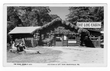
Postcard (Item) - Black and white postcard, Rose Stereograph Company, Souvenir & Gift Shop, Marysville, Vic, 1913-1967
A black and white postcard of The Log Cabin in Marysville in Victoria. A black and white postcard of The Log Cabin in Marysville in Victoria. The Log Cabin was built by Thomas Henry Branchflower who had arrived from England late in 1921. It was built for Gwendoline Pitman after the death of her father Clarence Pitman and the disappearance of her sister Olive in July 1926. Gwendoline operated an artist and souvenir shop in the newly built Log Cabin in partnership with Peter Mackey who was a Melbourne optician and artist. This postcard was produced by the Rose Stereograph Company as a souvenir of Marysville.POST CARD The "Rose" Series/ De Luxe A Real Photograph/ Produced in Australia Published by the Rose Stereograph Co./ Armadale, Victoria. Log Cabin/ 1954-55 MARY-LYN GUEST HOUSE/ BONES & FISKE, Prop. This is where we buy/ all our stuff./ Real modern insidethe log cabin, thomas henry branchflower, gerald branchflower, marysville, mary chain, gwendoline pitman, clarence pitman, kooringa guesthouse, olive pitman, wilbur anderson, peter mackey, rose series postcard, rose stereograph co, p. 4573, postcard, souvenir -
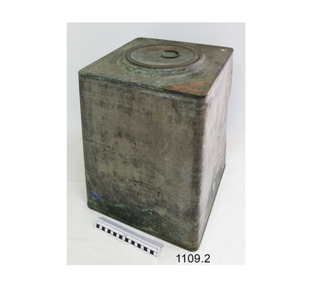 Flagstaff Hill Maritime Museum and Village
Container - Copper Drum, 1903
This copper and tin container was used for the storage and transport of cordite that replaced black powder in 1889 as a military propellant. The stamped of a government broad arrow and date 1903 show the item was made for the war department and not for commercial use. The container once empty of explosives was used for many years as a flour bin on board the crayfish ketch "Lady Brassey" by Mr Charlie Washbourne, Crib Point, Australia (on the Mornington Peninsula in Victoria). The ketch Lady Brassey was probably named after Anna or "Annie" Brassey (née Allnutt), Baroness Brassey (7 October 1839 – 14 September 1887) who was an English traveller and writer. Her bestselling book A Voyage in the Sunbeam, Our Home on the Ocean for Eleven Months (1878) describes a voyage around the world including a visit to Australia.The explosives container is an example of how explosive compounds were stored and transported at the turn of the 20th century. It is significate as it is in very good condition and an artefact from Australia's colonial history around the Federation, just as the country was gaining independence from Britain.Metal box with tin sides, copper top and base and round, double layered lid that has a folding, D shaped handle. Referred to as a cordite container or copper drum. Inscriptions are stamped onto the drum and are on a sticker under the lid.Handle stamped "S & Co. 1900" on lid. Base is stamped "R.G.D. 1903" (meaning the container seals are resistant to Rapid Gas Decompression (RGD)") Logo: triangular "(vertical arrow) / A T " between letters and date. Base also has blue plastic label "N.T. 55" Sticker: "B55". flagstaff hill, warrnambool, flagstaff hill maritime museum, maritime museum, shipwreck coast, flagstaff hill maritime village, great ocean road, copper container, gunpowder container, government issue container, r.g.d. 1903, lady brassey, charlie washbourne, crib point, baroness brassey, cordite container, copper drum, gun powder container, gun powder, black powder, black powder container, explosives storage, crayfish ketch -
 Ballarat Tramway Museum
Photograph - Digital image, Wal Jack, 20/08/1955 12:00:00 AM
Yields information about the trams used by the AETA for a Ballarat tour to celebrate the Golden Jubilee of electric trams.Digital image from the Wal Jack Ballarat Album of the AETA Ballarat Golden Jubilee tour of 20/8/1955, of Specials 21 and 38, and service car 20 at the Victoria St Terminus. Photo Wal Jack. See image i2 for rear of photograph. See image i3 for hi res scan of print. See image i4 for hi res scan of negativeOn rear of photograph in ink "SEC Ballarat AETA Specials Nos 21 & 38, Service car No. 20, Victoria St terminus 20-8-55, 1905 - 1955, Celebration of electric trams in Ballarat". Has Wal Jack stamp in top right hand corner with number "T183" written in.trams, tramways, aeta, tours, golden jubilee of trams, victoria st, tram 21, tram 38, tram 20 -
 Eltham District Historical Society Inc
Photograph - Aerial Photograph, Landata, Research, Vic, Apr. 1963
Centred on present day Marconi Court, Research bounded by Maroondah Aqueduct to north, Thompson Crescent to south, Joselyn Drive to east and Eltham Research Oval to west. Historic Aerial Imagery Source: Landata.vic.gov.au Aerial Photo Details: Project No :486 Project : MELBOURNE (1963) PROJECT Run : 5 Frame : 62 Date : 04/1963 Film Type : B/W Camera : RC8 Flying Height : 5100 Scale : 9600 Film Number : 1805 GDA2020 : 37°42'24"S, 145°10'43"E MGA2020 : 339434, 5825157 (55) Melways : 22 F3 (ed. 42)aerial photo, neil webster collection, 1963-04, joselyn drive, marconi court, melway 22f3, research (vic.), research oval, thompson crescent -
 Eltham District Historical Society Inc
Photograph - Aerial Photograph, Landata, Research, Vic, Apr. 1972
Centred on present day Maroong Drive, Research bounded by Allendale Road to north, Thompson Crescent to south, Eltham College to east and Parsons Road to west. Historic Aerial Imagery Source: Landata.vic.gov.au Aerial Photo Details: Project No :985 Project : MELBOURNE 1972 Run : 26 Frame : 193 Date : 04/1972 Film Type : B/W Camera : RC10 Flying Height : 5700 Scale : 9600 Film Number : 2636 GDA2020 : 37°42'04"S, 145°10'33"E MGA2020 : 339187, 5825794 (55) Melways : 22 F1 (ed. 42)aerial photo, neil webster collection, 1972-04, allendale road, eltham, eltham barrel, eltham college, maroong drive, melway 22f1, parsons road, research (vic.), thompson crescent -
 Eltham District Historical Society Inc
Photograph - Aerial Photograph, Landata, Eltham, Vic, Apr. 1972
Centred on present day Ryans Road at Sandra Avenue, Eltham bounded by Progress Road to north, Brougham Street to south, Bible Street to east and Outlook Crescent to west. Historic Aerial Imagery Source: Landata.vic.gov.au Aerial Photo Details: Project No :985 Project : MELBOURNE 1972 Run : 27 Frame : 48 Date : 04/1972 Film Type : B/W Camera : RC10 Flying Height : 5700 Scale : 9600 Film Number : 2636 GDA2020 : 37°42'41"S, 145°08'38"E MGA2020 : 336392, 5824574 (55) Melways : 21 H4 (ed. 42)aerial photo, neil webster collection, 1972-04, eltham, bible street, brougham steet, melway 21h4, outlook crescent, progress road, ryans road, sandra avenue, montmorency -
 Eltham District Historical Society Inc
Photograph - Aerial Photograph, Landata, Montmorency, Vic, Apr. 1972
Centred on present day Olympic Avenue at Grand Boulevard, Montmorency bounded by Meruka Drive to north, Main Road to south, Main Road to east and Alban Street to west. Historic Aerial Imagery Source: Landata.vic.gov.au Aerial Photo Details: Project No :985 Project : MELBOURNE 1972 Run : 28 Frame : 206 Date : 04/1972 Film Type : B/W Camera : RC10 Flying Height : 5700 Scale : 9600 Film Number : 2635 GDA2020 : 37°43'21"S, 145°07'46"E MGA2020 : 335154, 5823329 (55) Melways : 21 E7 (ed. 42)aerial photo, neil webster collection, 1972-04, eltham, alban street, grand boulevard, lower plenty, main road, melway 21e7, meruka drive, montmorency, olympic avenue -
 Eltham District Historical Society Inc
Photograph - Aerial Photograph, Landata, Eltham, Vic, Apr. 1972
Centred on present day Mays Road at Stringybark Road, Eltham bounded by Nyora Road to north, Yarra River to south, Reynolds Road to east and Bible Street to west. Historic Aerial Imagery Source: Landata.vic.gov.au Aerial Photo Details: Project No :985 Project : MELBOURNE 1972 Run : 28 Frame : 209 Date : 04/1972 Film Type : B/W Camera : RC10 Flying Height : 5700 Scale : 9600 Film Number : 2635 GDA2020 : 37°43'33"S, 145°09'28"E MGA2020 : 337647, 5823013 (55) Melways : 22 B8 (ed. 42)aerial photo, neil webster collection, 1972-04, eltham, bible street, mays road, melway 22b8, nyora road, reynolds road, stringybark road, yarra river -
 Eltham District Historical Society Inc
Photograph - Aerial Photograph, Landata, Eltham, Main Road; Henry St to Bellevue Rd, Dec. 1945
Eltham, Main Road; Henry St to Bellevue Rd, and east along Luck St to present day Eltham East School Historic Aerial Imagery Source: Landata.vic.gov.au Aerial Photo Details: Project No :5 Project : MELBOURNE AND METROPOLITAN AREA PROJECT Run : 36 Frame : 60549 Date : 12/1945 Film Type : B/W Camera : EAG4 Flying Height : 10200 Scale : 6000 Film Number : 228 GDA2020 : 37°42'45"S, 145°08'59"E MGA2020 : 336903, 5824465 (55) Melways : 21 K4 (ed. 42)aerial photo, arthur street, bellevue road, bible street, diamond street, dudley street, elsa court, eltham, eltham east primary school, gahan house, henry street, livingstone road, luck street, main road, pryor street, neil webster collection -
 Eltham District Historical Society Inc
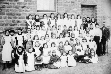
Negative - Photograph, Theodor Black, Eltham State School No. 209, 1905
John Brown (Head Teacher 1889-1906), assistant Ellen Sweeney and 53 schoolgirls, Eltham State School No. 209, 1905 Ina Falkiner is top row 4th from left Gertrude Falkiner is bottom row seated 4th from left. John Brown died 23 Sept 1906 after a short severe illness at age 55 and is buried in Box Hill Cemetery (Evelyn Observer 28 Sep 1906 p2). The book "We did open a school in Little Eltham" incorrectly states his date of death as 16/12/1906. Title The Evelyn Observer. (1906, September 28). Evelyn Observer and Bourke East Record (Vic. : 1902 - 1917), p. 2 (MORNING.) Url http://nla.gov.au/nla.news-article61129880 Description It is with sincere regret we record the death of Mr. John Brown, State school teacher, Eltham, which sad event took place at his residence, "Pine Brae," on Sunday night last, 23rd inst. after a severe illness of some few weeks' duration. The deceased gentleman was highly respected, and always took a lively and active interest in promoting the progress and prosperity of the district, and his loss will be much felt, He was only 55 years of age, and leaves a wife and large family to mourn their loss, and much sympathy is felt for them. The remains of the deceased were interred in the Box Hill cemetery on Wednesday afternoon last.Roll of 35mm colour negative film, 3 strips Associated print from negative (Copy of original print)Fuji 100eltham primary school, state school no. 209, eltham state school, eltham state school no. 209, ellen sweeney, gretrude falkiner, ina falkiner, john brown -
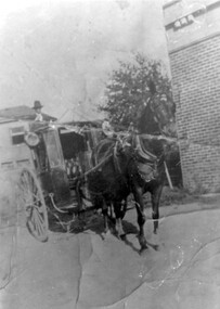 Surrey Hills Historical Society Collection
Photograph, Fred Lyons and his hansom cab
This is one of a series of photos donated by Arthur Lyons. From 1907 a cab service operated from near the railway gates in Union Road. It was established and maintained by Mr C Fraser until c1916. George Rea either took over then or set up in opposition. Fred Lyons initially worked for George until he set up his own business. In time he changed over to a motor vehicle and continued his service until 1960. Frederick Adolphus Lyons (1891-1980) was born in Surrey Hills, son of Thomas and Catherine Lyons. He married Elizabeth Ruby Hall in 1918. They lived just around the corner at 55 Sunbury Crescent. The Lyons’ home in Sunbury Crescent was called ‘Knopshambury’ - this was probably a misspelling of Knockshanbally in Co Kilkenny, the birth place of Fred’s father, Thomas Edmund Josias Lyons (1846-1915). Arthur Lyons was born in Surrey Hills on 12 Jun 1920. He became a motor mechanic / welder and lived at 55 Sunbury Crescent. The donation was made while he was in hospital. He died shortly afterwards (23 Sep 1990). Donation was finalised by a neighbour, Mrs Florence Ann Armitstead, wife of Glen Victor Armitstead. Glen was a local hairdresser. They moved to 11 Sunbury Crescent after their marriage in 1939. Arthur had no relatives to distribute the material to.Black and white photo of Fred Lyons with his hansom cab, taken between 1916-1920. It shows a horse harnessed to the cab, the door of which is open so that the buttoned seat is visible. The cab has large lamps on each side. Mr Lyons, in hat, is standing on the back of the cab. There is a large brick wall of a building to the right of the cab with a mature tree beside it and houses can be seen behind the cab. horse-drawn vehicles, carriages and coaches, fred lyons, george rea, frederick adolphus lyons -
 Surrey Hills Historical Society Collection
Photograph, Fred Lyons with son Arthur of Surrey Hills
This is one of a series of photos donated by Arthur Lyons. From 1907 a cab service operated from near the railway gates in Union Road. It was established and maintained by Mr C Fraser until c1916. George Rea either took over then or set up in opposition. Fred Lyons initially worked for George until he set up his own business. In time he changed over to a motor vehicle and continued his service until 1960. Frederick Adolphus Lyons (1891-1980) was born in Surrey Hills, son of Thomas and Catherine Lyons. He married Elizabeth Ruby Hall in 1918. They lived just around the corner at 55 Sunbury Crescent. The Lyons’ home in Sunbury Crescent was called ‘Knopshambury’ - this was probably a misspelling of Knockshanbally in Co Kilkenny, the birth place of Fred’s father, Thomas Edmund Josias Lyons (1846-1915). Arthur Lyons was born in Surrey Hills on 12 Jun 1920. He became a motor mechanic / welder and lived at 55 Sunbury Crescent. The donation was made while he was in hospital. He died shortly afterwards (23 Sep 1990). Donation was finalised by a neighbour, Mrs Florence Ann Armitstead, wife of Glen Victor Armitstead. Glen was a local hairdresser. They moved to 11 Sunbury Crescent after their marriage in 1939. Arthur had no relatives to distribute the material to.A black and white photograph of Arthur Lyons standing by his father who is seated with a fox terrier on his lap. They are in front of a paling fence which in turn is in front of a brick building with a veranda. On the back in black pen " Lyons/Sunbury Cres" and in pencil "copied 1996"taxis, drivers, sunbury crescent, surrey hills, fred lyons, frederick adolphus lyons, arthur lyons, arthur frederick lyons -
 Surrey Hills Historical Society Collection
Photograph, Fred Lyons, taxi driver of Surrey Hills
This is one of a series of photos donated by Arthur Lyons. From 1907 a cab service operated from near the railway gates in Union Road. It was established and maintained by Mr C Fraser until c1916. George Rea either took over then or set up in opposition; he retired in 1945. Fred Lyons initially worked for George until he set up his own business. In time he changed over to a motor vehicle and continued his service until 1960. Frederick Adolphus Lyons (1891-1980) was born in Surrey Hills, son of Thomas and Catherine Lyons. He married Elizabeth Ruby Hall in 1918. They lived just around the corner at 55 Sunbury Crescent. The Lyons’ home in Sunbury Crescent was called ‘Knopshambury’ - this was probably a misspelling of Knockshanbally in Co Kilkenny, the birth place of Fred’s father, Thomas Edmund Josias Lyons (1846-1915). Arthur Lyons was born in Surrey Hills on 12 Jun 1920. He became a motor mechanic / welder and lived at 55 Sunbury Crescent. The donation was made while he was in hospital. He died shortly afterwards (23 Sep 1990). Donation was finalised by a neighbour, Mrs Florence Ann Armitstead, wife of Glen Victor Armitstead. Glen was a local hairdresser. They moved to 11 Sunbury Crescent after their marriage in 1939. Arthur had no relatives to distribute the material to.Black and white photo of Fred Lyons dressed in suit and cap standing on the footpath beside his taxi. Behind the taxi is another car approaching from a street at right angles. There are wide stretches of grass planted with trees including palm trees. In the background are houses with picket fences; the most visible house is clearly Victorian in style. transport, businesses, taxis, fred lyons, frederick adolphus lyons, uniforms -
 Surrey Hills Historical Society Collection
Photograph, Fred Lyons, cab and taxi proprietor, Surrey Hills
This is one of a series of photos donated by Arthur Lyons. From 1907 a cab service operated from near the railway gates in Union Road. It was established and maintained by Mr C Fraser until c1916. George Rea either took over then or set up in opposition. Fred Lyons initially worked for George until he set up his own business. In time he changed over to a motor vehicle and continued his service until 1960. Frederick Adolphus Lyons (1891-1980) was born in Surrey Hills, son of Thomas and Catherine Lyons. He married Elizabeth Ruby Hall in 1918. They lived just around the corner at 55 Sunbury Crescent. The Lyons’ home in Sunbury Crescent was called ‘Knopshambury’ - this was probably a misspelling of Knockshanbally in Co Kilkenny, the birth place of Fred’s father, Thomas Edmund Josias Lyons (1846-1915). Arthur Lyons was born in Surrey Hills on 12 Jun 1920. He became a motor mechanic / welder and lived at 55 Sunbury Crescent. The donation was made while he was in hospital. He died shortly afterwards (23 Sep 1990). Donation was finalised by a neighbour, Mrs Florence Ann Armitstead, wife of Glen Victor Armitstead. Glen was a local hairdresser. They moved to 11 Sunbury Crescent after their marriage in 1939. Arthur had no relatives to distribute the material to.A black and white studio portrait of a man wearing round eye glasses, a white shirt and dark coloured striped tie.George Lyonssunbury crescent, surrey hills, union street, taxi proprietor, fred lyons, frederick adolphus lyons -
 Emerald Museum & Nobelius Heritage Park
Administrative record - Nobelius Nursery Cash book, October 1903- December 1910, 16/10/1903 - 18/12/1910
The Cash Accounts contain the names and transaction details of all Gembrook Nursery clients. As well as private individuals, clients also included the following: Fitzroy City Council (p.2, 23, 41, 58. 93); Collingwood Council (p.2, 11, 54, 62, 71, 93); Lands Dept (p.2,5, 28, 30, 45, 61, 73); Melbourne Water Supply (p. 2); Victorian Railways (p.4, 6, 7,17,19, 20, 21, 22, 23, 24, 25, 27, 29, 31, 32, 33, 35, 37, 47......); Salvation Army (p.5, 36, 72, 94); Hawthorn Council (p.11, 37, 57, 69); Kew Council (p.12, 34, 55); Caulfied Shire Council (p.14, 35, 37,53, 69, 90, 93, 108); City of Melbourne (p. 26, 54, 96); Narre Warren Library (p. 44)., Public Works Dept (p. 55); Nunawading Shire Council (p. 70); Prahran Shire Council (p. 91, 102, 108); Dept of Agriculture N.Z.(p. 93); Hawkesbury Ag College (p. 93); Cremorne Nursery (p. ......., 94); Stawell Shire Council (p. 95); Monbulk Jam Factory (p. 100, Euroa shire Council (p. 108))The accounts also track Nobelius' travel expenses.The cash account books are historically, and socially significant as the entries give an insight into the growth of the company and the details payments from local and other government offices and overseas customers as well as significant companies associations and people. The earlier account books also detail wage payments.Hard cover cash book, brown leather binding, black cover, pink marbled end paper, book has 239 pages all used, date starts 16th October 1903 and ends 18th December 1910. c. a. nobelius & sons, gembrook nurseries, horticulture, accounting, emerald -
 Emerald Museum & Nobelius Heritage Park
Administrative record - Nobelius Nursery Cash Book, 1895-1908, 21 August 1895 - 12 October 1903
The Cash Accounts contain the names and transaction details of all Gembrook Nursery clients. As well as private individuals, clients also included the following: Fitzroy City Council (p.2, 23, 41, 58. 93); Collingwood Council (p.2, 11, 54, 62, 71, 93); Lands Dept (p.2,5, 28, 30, 45, 61, 73); Melbourne Water Supply (p. 2); Victorian Railways (p.4, 6, 7,17,19, 20, 21, 22, 23, 24, 25, 27, 29, 31, 32, 33, 35, 37, 47......); Salvation Army (p.5, 36, 72, 94); Boroondara Council (p.11, 37, 57, 69); Kew Council (p.12, 34, 55); Caulfied Shire Council (p.14, 35, 37,53, 69, 90, 93, 108); City of Melbourne (p. 26, 54, 96); Narre Warren Library (p. 44)., Public Works Dept (p. 55); Nunawading Shire Council (p. 70); Prahran Shire Council (p. 91, 102, 108); Dept of Agriculture N.Z.(p. 93); Hawkesbury Ag College (p. 93); Cremorne Nursery (p. ......., 94); Stawell Shire Council (p. 95); Monbulk Jam Factory (p. 100, Euroa shire Council (p. 108))The accounts also track Nobelius' travel expenses.The cash account books are historically, and socially significant as the entries give an insight into the growth of the company and the details payments from local and other government offices and overseas customers as well as significant companies associations and people. The earlier account books also detail wage payments.Hard cover cash book, with maroon embossed cover (alligator print cover), inner cover marbled front and back, cash book has a total of 139 pages all used, date starts 1895 and concludes in 1908c. a. nobelius & sons, gembrook nurseries, horticulture, accounting, emerald -
 Eltham District Historical Society Inc
Photograph - Aerial Photograph, Landata, Eltham / Research, Vic, Jan. 1951
Centred on Brinkkotter Road opposite Yarramie Reserve, Eltham bounded by Maroondah Aqueduct to north, Nyora Road to south, Eltham College to east and Leane Drive to west. Historic Aerial Imagery Source: Landata.vic.gov.au Aerial Photo Details: Project No :65 Project : MELBOURNE AND METROPOLITAN PROJECT NO. 2 Run : 7 Frame : 8 Date : 01/1951 Film Type : B/W Camera : EAG9 Flying Height : 12200 Scale : 12000 Film Number : 1419 GDA2020 : 37°42'32"S, 145°10'41"E MGA2020 : 339408, 5824924 (55) Melways : 22 F3 (ed. 42)Historical aerial photos and photo maps provide viusal evidence of the chronology of changes to the built landscape of the district and assist in dating other imagesaerial photo, 1951-01, eltham, neil webster collection, brinkkotter road, eltham college, leane drive, maroondah aqueduct, melways 22f3, nyora road, yarramie reserve -
 Eltham District Historical Society Inc
Photograph - Aerial Photograph, Landata, Eltham, Vic, Jan. 1951
Centred on Beard Street between Main Road and Frank Street, Eltham bounded by Maroondah Aqueduct to north, Arthur Street to south, Maroong Drive to east and Catholic Ladies College to west. Historic Aerial Imagery Source: Landata.vic.gov.au Aerial Photo Details: Project No :65 Project : MELBOURNE AND METROPOLITAN PROJECT NO. 2 Run : 7 Frame : 9 Date : 01/1951 Film Type : B/W Camera : EAG9 Flying Height : 12200 Scale : 12000 Film Number : 1419 GDA2020 : 37°42'23"S, 145°09'39"E MGA2020 : 337874, 5825170 (55) Melways : 22 B3 (ed. 42)Historical aerial photos and photo maps provide viusal evidence of the chronology of changes to the built landscape of the district and assist in dating other imagesaerial photo, 1951-01, eltham, neil webster collection, arthur street, beard street, catholic ladies college, frank street, main road, maroondah aqueduct, maroong drive, melway 22b3, research (vic.) -
 Eltham District Historical Society Inc
Photograph - Aerial Photograph, Landata, Eltham North, Feb. 1956
Centred on present day 54 Kelway Crescent, Eltham North bounded by Glen Gully Road to north, Meruka Drive to south, Eltham College to east and Leach Street to west. Historic Aerial Imagery Source: Landata.vic.gov.au Aerial Photo Details: Project No :250 Project : MELBOURNE OUTER SUBURBS PROJECT Run : 17 Frame : 113 Date : 02/1956 Film Type : B/W Camera : EAG9 Flying Height : 10000 Scale : 12000 Film Number : 1176 GDA2020 : 37°42'16"S, 145°08'08"E MGA2020 : 335650, 5825336 (55) Melways : 21 G2 (ed. 42)aerial photo, 1956-02, eltham, eltham north, glen gully road, leach street, main road, melway 21g2, meruka drive, montmorency, neil webster collection -
 Eltham District Historical Society Inc
Photograph - Aerial Photograph, Landata, Montmorency, Feb. 1956
Centred on present day Tahlee Place Reserve and Sherbourne Preschool, Montmorency bounded by Progress Road to north, Withers Way to south, Main Road to east and Leach Street to west. Historic Aerial Imagery Source: Landata.vic.gov.au Aerial Photo Details: Project No :250 Project : MELBOURNE OUTER SUBURBS PROJECT Run : 17 Frame : 114 Date : 02/1956 Film Type : B/W Camera : EAG9 Flying Height : 10000 Scale : 12000 Film Number : 1176 GDA2020 : 37°42'50"S, 145°08'02"E MGA2020 : 335512, 5824286 (55) Melways : 21 F5 (ed. 42)aerial photo, 1956-02, neil webster collection, central park, eltham, leach street, main road, melway 21f5, montmorency, progress road, withers way, sherbourne preschool, tahlee place reserve -
 Eltham District Historical Society Inc
Photograph - Aerial Photograph, Landata, Lower Plenty, Feb. 1956
Centred on present day 217 Old Eltham Road, Lower Plenty bounded by Pitt Street to north, Yarra River to south, Main Road to east and Bonds Road to west. Historic Aerial Imagery Source: Landata.vic.gov.au Aerial Photo Details: Project No :250 Project : MELBOURNE OUTER SUBURBS PROJECT Run : 17 Frame : 116 Date : 02/1956 Film Type : B/W Camera : EAG9 Flying Height : 10000 Scale : 12000 Film Number : 1176 GDA2020 : 37°43'58"S, 145°07'49"E MGA2020 : 335237, 5822186 (55) Melways : 21 E10 (ed. 42)aerial photo, 1956-02, neil webster collection, eltham, main road, bonds road, elham, lower plenty, melway 21e10, pitt street, yarra river -
 Eltham District Historical Society Inc
Photograph - Aerial Photograph, Landata, Eltham, Feb. 1956
Centred on present day Shalbury Avenue, Eltham bounded by Leane Drive and Parsons Road to north, Nyora Road to south, Reynolds Road to east and the Diamond Creek to west Historic Aerial Imagery Source: Landata.vic.gov.au Aerial Photo Details: Project No :250 Project : MELBOURNE OUTER SUBURBS PROJECT Run : 18 Frame : 95 Date : 02/1956 Film Type : B/W Camera : EAG9 Flying Height : 10000 Scale : 12000 Film Number : 1176 GDA2020 : 37°41'57"S, 145°09'51"E MGA2020 : 338145, 5825965 (55) Melways : 22 C1 (ed. 42)aerial photo, 1956-02, neil webster collection, eltham, diamond creek (creek), melway 22c1, nyora road, parsons road, reynolds road, shalbury avenue