Showing 14772 items
matching north road
-
 Greensborough Historical Society
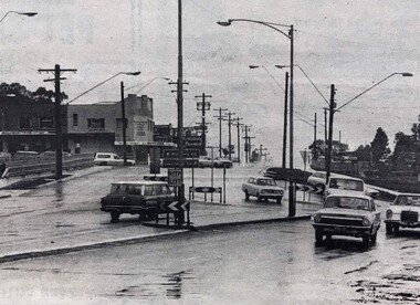
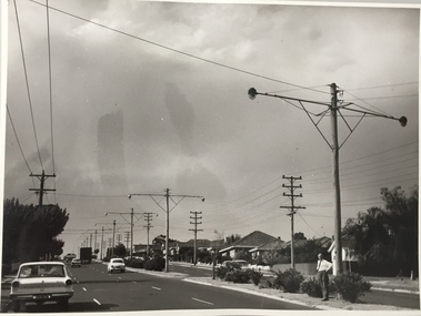
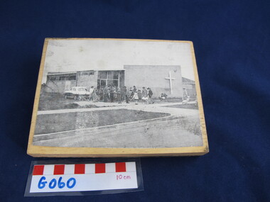
Photograph - Digital Image, Watsonia Junction 1968, 1978_
... Watsonia junction 1978. Looking north from Greensborough... north from Greensborough Road to Lambourn Road and Watsonia Road ...Watsonia junction 1978. Looking north from Greensborough Road to Lambourn Road and Watsonia Road. Digital copy of black and white photographswatsonia shopping centre, lambourn road watsonia, watsonia road watsonia -
 Eltham District Historical Society Inc
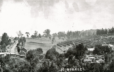
Photograph, Tom Prior, Research
... Taken north along Ingrams Road after turning the bend... melbourne Taken north along Ingrams Road after turning the bend ...Taken north along Ingrams Road after turning the bend, the area was known for its orchards.The Reynolds family were early settlers in Research. The Reynolds/ Prior collection of photographs were taken by Tom Prior, the maternal uncle of Ivy Reynolds, around 1900 and the 60 photos in the album give a fine overview of many of the landmarks of Research and Eltham over 100 years ago. lvy lived in the family home for many years at 106 Thompson Cres Research. Ivy's father, Ernst Richard Reynolds and grandfather, Richard Reynolds, lived at the same address. Ivy's father Richard worked for Mr. Trail on his property in Research. Reynolds Road is named after the family. Mr Tom Prior (wife Eva) worked at the Melbourne zoo. He was very innovative and made his own camera, using the black cloth hood to exclude the light. The photographs are a reminder of the rural nature of Research and Eltham and its rich heritage. Black and white photograph mounted in an album, the Reynolds/Prior Photograph Collection, this being one of 53 reproduced black and white images of early Eltham.The Reynolds/Prior Photograph Collection, Presented to the Eltham District Historical Society, 14 June 2006 by Ross McDonald. A second copy was also presented to the Andrew Ross Museum, Kangaroo Groundingrams road, orchards, research (vic.), reynolds prior collection -
 Melbourne Tram Museum
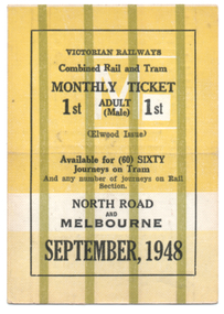
Ephemera - Rail & Tram Monthly ticket, Victorian Railways (VR), Sept. 1948
... North Road to Melbourne, though the rail portion only provided... North Road to Melbourne, though the rail portion only provided ...Victorian Railways Rail & Tram Monthly Periodical with conditions of travel on the inside. See reference page 124/125 and Figure 6-33. All tickets were available for 60 only tram trips, but allowed unlimited rail trips with 60 separate squares for a tram conductor to punch. This ticket is for First class travel, from North Road to Melbourne, though the rail portion only provided for first-class travel. Ticket No. 002 for September 1948. Colour of the ticket and markings varied for each month. Ticket has been cancelled with two red lines on one side.Demonstrates a Victorian Railways Rail and Tram monthly ticket for a specific section or trip on the St Kilda Brighton tramway. May have been used as a training sample.Printed card ticket, heavy card, coloured, with a crease in the middle so it could be folded.tickets, vr, vr trams, victorian railways, st kilda brighton tramway, monthy -
 Whitehorse Historical Society Inc.
Article, Orchard estate land set to become townhouses, 2013
... . of Junction and Surrey Roads Blackburn North, formerly part... Blackburn North Nos. 59-67 Cock Herbert Junction Road Blackburn ...Report of sale of a 1.03 hectare property on cnr. of Junction and Surrey Roads Blackburn North.Report of sale of a 1.03 hectare property on cnr. of Junction and Surrey Roads Blackburn North, formerly part of an orchardReport of sale of a 1.03 hectare property on cnr. of Junction and Surrey Roads Blackburn North.surrey road, blackburn north nos. 59-67, cock, herbert, junction road, blackburn north, orchards -
 Whitehorse Historical Society Inc.
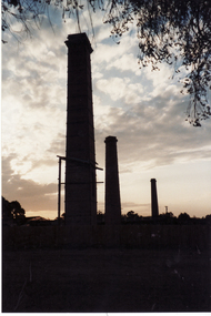
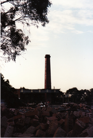
Photograph, Vitclay, 1995
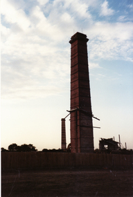
... Road, Blackburn North, looking West from Primrose Street.... Mitcham melbourne vitclay springfield road blackburn north ...Vitclay Chimneys prior to demolition in 1995. Springfield Road, Blackburn North, looking West from Primrose Street.vitclay, springfield road, blackburn north, potteries, clay industries -
 Whitehorse Historical Society Inc.
Photograph, Vitclay, 1995
... Road, Blackburn North, looking West from Primrose Street.... Mitcham melbourne vitclay springfield road blackburn north ...Vitclay Chimney, prior to demolition in 1995. Springfield Road, Blackburn North, looking West from Primrose Street.vitclay, springfield road, blackburn north, potteries, clay industries -
 Whitehorse Historical Society Inc.
Photograph, Blackburn High School, 2012
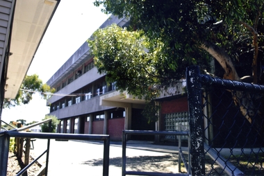
... buildings on the corner of Springfield and William Road, Blackburn... and William Road, Blackburn North - 2012 Blackburn High School ...Blackburn High School was opened in 1956. It was built on land previously covered with orchards owned by Mr Ron Pearce who was famous for growing cherries. In 1980 the school celebrated their silver jubilee. Blackburn High School has long been known for its successful music education program.Coloured photograph of recent Blackburn High School buildings on the corner of Springfield and William Road, Blackburn North - 2012blackburn high school, secondary schools, schools -
 Whitehorse Historical Society Inc.
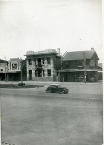
Photograph, State Savings Bank of Victoria, Mitcham
... of Victoria, Mitcham, taken from the north side of Whitehorse Road..., Mitcham, taken from the north side of Whitehorse Road State ...Black and white photograph of the State Savings Bank of Victoria, Mitcham, taken from the north side of Whitehorse Roadstate savings bank of victoria, mitcham, banks -
 Ringwood and District Historical Society
Uniform - Windcheater, Rugger, School windcheater - purple with yellow lettering and logo - Norwood High School circa 1980, c.1980
... Glendale Road, North Ringwood. Acquired July 2011.... Road Ringwood North melbourne Given to the Ringwood Historical ...Given to the Ringwood Historical Society by Margaret Williams - her daughter's windcheater used in the 1980'sSchool windcheater - purple with yellow lettering and logo - Norwood High School. +Additional Keywords: Williams, Margaret, 161 Glendale Road, North Ringwood. Acquired July 2011.Norwood High School -
Whitehorse Historical Society Inc.
Article, Concern At Road Plans, 15/01/1997 12:00:00 AM
... for postponement of finalisation of 10 year north eastern regional road...Whitehorse Historical Society Inc. 2-10 Deep Creek Road ...The Koonung Mullum Freeway Association calls for postponement of finalisation of 10 year north eastern regional road strategy.The Koonung Mullum Freeway Association calls for postponement of finalisation of 10 year north eastern regional road strategy until return of elected Councillors on 15th March 1997.The Koonung Mullum Freeway Association calls for postponement of finalisation of 10 year north eastern regional road strategy.freeways, koonung mullum forestway association, vicroads, city of whitehorse -
Whitehorse Historical Society Inc.
Map, Cadastral Map System, 2005
... Land Victoria map of section of Blackburn North, inc... dimensions. Middleborough Road Blackburn North Joseph Street ...Land Victoria map of section of Blackburn North.Land Victoria map of section of Blackburn North, inc. Middleborough Road, Joseph Street and Chapman Street. Scale: 1:1500. With Lot Nos. and block frontage dimensions.Land Victoria map of section of Blackburn North. middleborough road, blackburn north, joseph street, blackburn north, chapman street, blackburn north -
 Tarnagulla History Archive
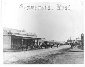
Photograph of Commercial Road, Tarnagulla, June 1866
... Monochrome photograph looking north down Commercial Road... photograph looking north down Commercial Road, Tarnagulla from ...Murray Comrie Collection. Copy of an 1866 photograph by Aimé Marchand. Thomas Comrie's Exchange Store was at south end of Commercial Road, it has since been destroyed. In June 1866, Aimé Marchand (1846-1910) made a series of fourteen photographs which were submitted to the 1866-67 Melbourne Intercolonial Exhibition, where they earned a 1st Class Honorable Mention. This is one of those fourteen images. Of French or Belgian origin and possibly formerly an assayer in California, Marchand appears to have begun his practice of photography in Tarnagulla around 1865 as an assistant to A.B. Clay. By the following year he had settled in Portland, where he opened the Royal Photographic Studio in Gawler Street. From his base in Portland he toured surrounding districts, offering portrait and view services. Little else is known about his life. He appears to have left Australia in 1878. A misprint of his name in a local directory as Annie Marchand created the misconception that he was one of only a few named women photographers in the colonies. Monochrome photograph looking north down Commercial Road, Tarnagulla from the Wayman Street corner, opposite Thomson and Comrie's Exchange Store (at south end of Commercial Road).tarnagulla, views, thomas comrie, comrie exchange store, commercial road, local people, residents, aimé marchand, photographers -
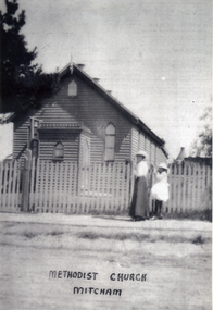 Whitehorse Historical Society Inc.
Photograph, Methodist Church - Mitcham
... the building was moved to a site in Mitcham Road, just north... in Mitcham Road, just north of Whitehorse Road. The church ...In 1887, land on the south east corner of Whitehorse Road and Richards Street, Mitcham was purchased and in 1888 a weatherboard church was erected. This early church was used until 1921, when the building was moved to a site in Mitcham Road, just north of Whitehorse Road. The church was enlarged and re-opened in 1921Black and white photograph of the Mitcham Methodist Church which was erected in 1888, on the corner of Whitehorse Road and Richard Street, Mitchammethodist church, mitcham -
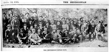 Tarnagulla History Archive
Photographs: The Newbridge Rifle Club (The Bendigonian), The Newbridge Rifle Club (The Bendigonian), October 22, 1901 (original)
... The Newbridge Rifle Club Butts were behind a big hill north... were behind a big hill north of road to Llanelly. Formed ...The Newbridge Rifle Club Butts were behind a big hill north of road to Llanelly. Formed in 1900 for rifle practice during the Boer War. Range of 500 yards. Brigade Captain Bob Douglas. Murray Comrie Collection. Two copies of a monochrome photograph, image depicting a large group of men assembled in an outdoor setting, some holding firearms. Printed caption reads: 'The Newbridge Rifle Club' Title printed on top of page reads 'The Bendigonian' and 'October (?) 22 1901'. This is a poor quality copy of an older original, possibly a news clipping. Copy probably made by Murray Comrie in the 1960s.Accompanying note identifies some subjects: Standing: 1. Will Hart (?) 2. _________ 3. John Brown 4. Donald Joyner 5. Geo. Daws 6. _______ 7. Nat Ramsay 8._______ 9.__________ 10. Alf Michael 11. Bod Hamilton 12. Jack Bruce 13. Vince Pola 14. Frank Bruce 15. Eli Summers 16. ____ 17. ____ 18. ______ 19. Bob Chamberlain 20. P. Rayner 21. Ted Skinner 22. Geo. Martin 23. Bill Michael. Sitting: 1. ______ 2.______ 3. ______ 4. Will Ramsay 5. Nat Hart 6. Bob Douglas (in uniform) 7. Jim Joyner 8. Steve Hatt 9. Bob McKenzie 10. Charlie Summers (in uniform) 11. William Bridge (in uniform) 12. Tom Michael (in uniform). (Not sure if this matches the photo very well. Note filed in M. Comrie research notes (general).)newbridge, sports, recreation, shooting, clubs, rifle club, military, boer war -
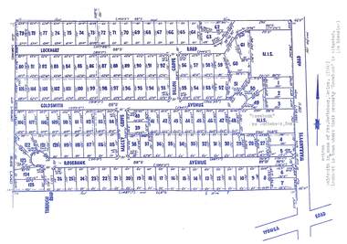 Ringwood and District Historical Society
Map, Subdivision Plan - Rosebank Avenue area, North Ringwood, Vic. - circa 1960s
... "Rosebank" property, Warrandyte Road, Ringwood North. Subdivision... surrounding "Rosebank" property, Warrandyte Road, Ringwood North ...Single page plan printed on green background showing allotments included in un-named subdivision layout surrounding "Rosebank" property, Warrandyte Road, Ringwood North. Subdivision includes Through Road, Rosebank Avenue, Macey Grove, Goldsmith Avenue, Dillon Grove, Lockhart Road, and Warrandyte Road.Typewritten notation against "Rosebank" property - "Mrs Godbehear, Snr.". "Goldsmith is maiden name of Mrs. Godbehear, Senior. (1960). Lockhart is town where their property "Rosebank" is situated. (In Riverina)". Additional Rosebank Avenue allotments blueprint clipping on light cardboard backing incldes handwritten title reference LP57659. -
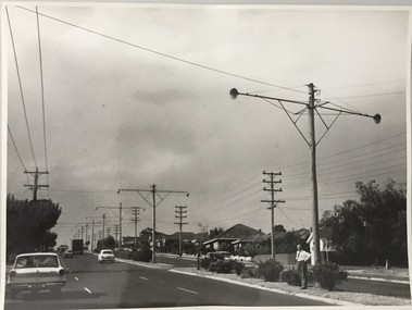 Kew Historical Society Inc
Photograph, Stuart Tompkins Studio, Electricity Supply Poles, Warrigal Road, Holmesglen, 1965
... Council. The photograph of Warrigal Road, north of Holmesglen.... Photographed for Kew City Council 8/2/65. No.3 Warrigal Road - North.... No.3 Warrigal Road - North of Holmesglen looking north. Wooden ...Research provided by Stuart Tompkins Studio, Box Hill, into alternatives for median strip street lighting to be used in Burke Road, Kew. The photographers identified variants in different suburbs appropriate to Kew's needs. The series from which the photograph is drawn provides a snapshot by a commercial photographic studio of each named vicinity in 1965 as well as providing examples of public works infrastructure being commissioned by local government in the 1960s. The photos originally formed part of the Engineering Department's files in the City of Kew before being donated to the kew Historical Society.Electricity Supply Poles, Warrigal Road, Holmesglen, 1965. Stuart Tompkins Studio provided this photograph for the Kew City Council. The photograph of Warrigal Road, north of Holmesglen looking north depicts wooden poles with bracket light fittings. These were the same as those proposed for Kew, except the lights and fittings were not to be 350 watt. Mercury lamps were preferred. [There are three copies of this photograph in the Collection.] Typed inscription on reverse: "Electricity Supply Poles. Photographed for Kew City Council 8/2/65. No.3 Warrigal Road - North of Holmesglen looking north. Wooden poles with bracket fittings same as those proposed for Kew except lights and fittings are not for 250 watt c. c. mercury lamps proposed. Wooden pole 3' up 11 3/4" dia." Studio stamp: "Stuart Tompkins Studio. 547 Station Street, Box Hill. WX1439."stuart tompkins studio, warrigal road (holmesglen) 1965, street lighting -
 Whitehorse Historical Society Inc.
Photograph, Vitclay, 1995
... by demolished sheds. Springfield Road, Blackburn North, looking North... Mitcham melbourne vitclay springfield road blackburn north ...Vitclay Chimney, prior to demolition in 1995, surrounded by demolished sheds. Springfield Road, Blackburn North, looking North-West.vitclay, springfield road, blackburn north, potteries, clay industries -
 Whitehorse Historical Society Inc.
Photograph, Our Lady of Fatima
... on the way to Whitefriars Monastery, along Whitehorse Road, Looking... Whitehorse Road, Looking north. Our Lady of Fatima Photograph ...Black and white photo of procession of Our Lady of Fatima on the way to Whitefriars Monastery, along Whitehorse Road, Looking north.whitefriars seminary, our lady of fatima procession, whitehorse road -
 Whitehorse Historical Society Inc.
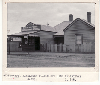
Photograph, H.W. Poyntz Tea Rooms Blackburn, C1918
... North side of Blackburn Road near Railway Gates... and Refreshment Rooms North side of Blackburn Road near Railway Gates H.W ...3 copies of H.W. Poyntz Post Office and Refreshment Rooms North side of Blackburn Road near Railway Gatespoyntz, henry -
Canterbury History Group
Photograph - Hazeldene, [1985]
... Balwyn Road, Canterbury, north side taken from the north/west.... of "Hazeldene" 8 Balwyn Road, Canterbury, north side taken from ...Black and white photograph of exterior of "Hazeldene" 8 Balwyn Road, Canterbury, north side taken from the north/west.canterbury, hazeldene, balwyn road, verandahs, cast iron work, gardens, danks family -
 Eltham District Historical Society Inc
Photograph - Aerial Photograph, Landata, Eltham North, Vic, Apr. 1972
... North Primary School, Eltham North bounded by Allendale Road... North Primary School, Eltham North bounded by Allendale Road ...Centred on present day Eltham North reserve near Eltham North Primary School, Eltham North bounded by Allendale Road to north, Bellevue Road to south, Zig Zag Road and Beard Street to east and Ryans Road to west. Historic Aerial Imagery Source: Landata.vic.gov.au Aerial Photo Details: Project No :985 Project : MELBOURNE 1972 Run : 26 Frame : 190 Date : 04/1972 Film Type : B/W Camera : RC10 Flying Height : 5700 Scale : 9600 Film Number : 2636 GDA2020 : 37°41'52"S, 145°08'52"E MGA2020 : 336705, 5826102 (55) Melways : 11 J12 (ed. 42)aerial photo, neil webster collection, 1972-04, allendale road, beard street, bellevue road, eltham, eltham north, eltham north reserve, melway 11j12, ryans road, zig zag road, eltham north primary school -
 Uniting Church Archives - Synod of Victoria
Printing block, c1959
... The image is of the Brooklyn Church, 9 Paringa Road, Altona...The image is of the Brooklyn Church, 9 Paringa Road, Altona ...The image is of the Brooklyn Church, 9 Paringa Road, Altona North. ?PresbyterianWooden block with metal plate on one side and photographic image on the other.brooklyn church -
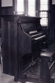 Whitehorse Historical Society Inc.
Photograph, Organ in Methodist Church, Mitcham
... was removed to a site in Mitcham Road, just north of Whitehorse Road... was removed to a site in Mitcham Road, just north of Whitehorse Road ...The earliest Methodist Church was on the corner of Whitehorse Road and Richards Street, Mitcham. In 1912 the church was removed to a site in Mitcham Road, just north of Whitehorse Road. By 1967 most of their buildings had been moved to the Presbyterian site on the corner of Whitehorse and Doncaster East Roads, Mitcham. Later the two denominations became the Uniting ChurchPhotograph of an organ in the Mitcham Methodist Church some time before the church closed in 1967. David Parker was long time organist at the church.methodist church, mitcham -
 Mt Dandenong & District Historical Society Inc.
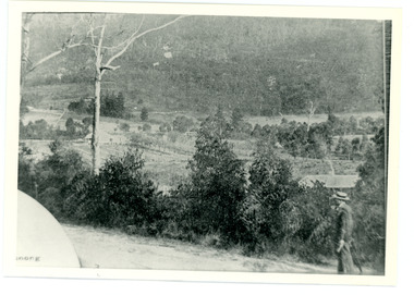
Photograph
... Dandenong Road, Montrose about 275 metres north of Sheffield Road.... from Mt Dandenong Road, Montrose about 275 metres north ...This photograph was taken c1908 and shows the view from Mt Dandenong Road, Montrose about 275 metres north of Sheffield Road.Black and white photograph showing a man in a white hat walking up a dirt road wth bush a nd a house roof to his right.mt dandenong, montrose, sheffield road -
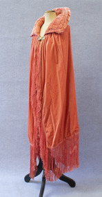 Brighton Historical Society
Cape, Opera cape, circa late 1920s
... aviatrix Amy Johnson in her North Road home in the early 1930s. Amy...) to a reception for English aviatrix Amy Johnson in her North Road home ...This velvet opera cape was worn by Agnes Emmeline "Dot" McCowan (nee Iredell, 1887-1969) to a reception for English aviatrix Amy Johnson in her North Road home in the early 1930s. Amy Johnson achieved worldwide fame in 1930 when she became the first woman to fly solo from England to Australia. Dot was the fourth child, and only surviving daughter, of Dr Charles Lesingham Maynard Iredell and Frances Keziah Iredell (née Hill), both formerly of Regents Park, London. Her parents had arrived in Australia in 1885 after Charles, a medical specialist, lost his money and house in the financial crash of 1880. In Melbourne, Charles established a reputation as an ear, nose and throat specialist and counted Dame Nellie Melba among his patients. Dot was schooled at Fairlight College in St Kilda. After falling from a tree at the age of twelve, she developed curvature of the spine. While recuperating, she took a correspondence course in theory and harmony of music with the Royal College of Music, London. She continued to pursue music after her recovery, ultimately winning an international scholarship to study piano and singing in Leipzig, Germany, but did not take up the offer due to her father's objections. She instead remained in Melbourne, where she put her skills to use as a music teacher. After her first fiancé disappeared at sea, Dot found happiness again with George Drummond. George owned a substantial property in Manjimup, Western Australia, and the couple planned to settle there after the wedding. It was not to be. Like many Australian men, George was killed in action on the Western Front during the First World War. It had become customary in George's wealthy family to give each son's bride a gift of one thousand pounds. Though Dot and George were never able to marry, the family nevertheless honoured the custom, and between their generous financial gift and her own teaching income, Dot was able to buy a well-appointed home at 9 North Road, Brighton for herself and her parents. The house remained in the family for many decades. In 1923, at the age of thirty-six, Dot met and fell in love with Alexander James McCowan. They were married on 28 February 1924; the reception was held in the North Road house.Salmon pink velvet opera cape with a padded collar and long fringe. Fastens at collar with a pair of circular metal clasps engraved with floral designs and accentuated with purple enamel. Silk lining.agnes emmeline iredell, agnes emmeline mccowan, opera cape, 1920s, 1930s, amy johnson -
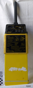 Flagstaff Hill Maritime Museum and Village
Equipment - EPIRB Transmitter
... North Road Hainault, Ilford Essex IG6 2UR" "ARMED / SAFE..."" "LOKATE LTD. New North Road Hainault, Ilford Essex IG6 2UR" "ARMED ...This distress EPIRB unit (Emergency Position Indication Radio Beacon) was found on the beach at Levy's Point, Warrnambool, in December 2000 by a Warrnambool resident. Local police were alerted at the time. This distress signal unit is a world-wide COSPAS/SARSAT, satellite assisted, SAR (Search and Rescue) system for location of distress transmissions emitted by an EPIRB. Offshore cruising vessels must have such a unit as part of its essential safety equipment. This model EPIRB relies on four satellites with orbit times of approximately 100 minutes. Earlier units relied solely on aircraft flying overhead to detect and forward on the EPIRB’s location to Search And Rescue authorities, whereas this new system utilises satellites. An employee from the Lokata firm provided additional information about the Lokata EPIRB units. They had a machined aluminium case with labels that were also made on site. The units could be activated manually or automatically released when a magnetic switch in the case casing was activated. This later model, circa 1983, would have been mounted externally on a vessel's bulkhead in a spring-loaded, stainless-steel protective 'skeleton' mounting, The unit released when the water pressure sensor detected a set time it was under the water, in a similar way that life crafts were released. Each unit was registered to a particular vessel - the vessel's details on this unit are indecipherable. The Lokata Company was established in 1970, designing and manufacturing marine products including communications. The company no longer makes products with the “Lokata” brand. In 2001 Sartech Engineering Ltd. took over the support for the Lokata EPIRB beacons. This emergency location device is a late 20th century invention to help save lives at sea. It adds to the history of maritime life, its risks, the lives lost as sea, and the many inventions aimed as rescuing and saving lives. The local area is notorious for the number of lives lost through shipwreck. It also carries stories of heroic efforts to save lives, and other inventions to help reduce the chance of accidents at sea.EPIRB unit; “Emergency Position Indication Radio Beacon”. A distress communication unit for sending a distress location transmission in an emergency at sea. The EPIRB is a yellow, rectangular box with dials, buttons, indicator lights and instruction. An antenna protrudes from the top of the unit. The EPIRB unit sends a 406P (X) EPIRB, with 406M-Hz frequency, 48-hour duration signal. The maker was LOKATA Ltd in England. Remnants of a white label remain on the side. Circa 1980s."NAME OF VESSEL 'SERVICE IF SELF TEST FAILS' " “LO-KATA” moulded into the body. "406P (X) EPIRB" “Model 406” "Lokata Type No 92408" "UK Type approved to MPT 1278" "Class 2" "Made by Lokata Ltd, Falmouth Cornwall England TR10 8AE"" "LOKATE LTD. New North Road Hainault, Ilford Essex IG6 2UR" "ARMED / SAFE / TRANSMIT / CODE / DISPLAY / SET / wait / pass / fail / TEST" "IDENTIFIER / 1349:24034234N" [some characters may be different] "COUNTRY / DENMARK" "VESSEL IDENTITY / 124 [the rest is indecipherable]flagstaff hill, warrnambool, shipwrecked-coast, flagstaff-hill, flagstaff-hill-maritime-museum, maritime-museum, shipwreck-coast, flagstaff-hill-maritime-village, emergency position indicating radio beacon, epirb, lokata ltd, marine safety equipment, satellite transmitting beacon, safety equipment, distress signal, life saving, safety at sea, shipwreck location, lo-kata, falmouth, emergency, beacon, radio signal, communication, marine equipment -
 Ringwood and District Historical Society
Photograph, Kubis Estate, North Ringwood in April 1978. View of the lake site looking east. The wall was where the track bends. The rope tree was on the hillside beyond the track bend
... of the "Kubis" Estate, Ringwood North, including road works to Debbie... Road Ringwood North melbourne E548 N35 This photo was taken ...E548 N35 This photo was taken from almost the same spot as the 1976 one. Part of a 51-photo record of the development of the "Kubis" Estate, Ringwood North, including road works to Debbie Place, Kubis Drive, Werac Drive, Manuelo Drive, Iluka Place and Glenvale Road. From the Jack Lundy Clarke collection. -
 Eltham District Historical Society Inc
Photograph, Jim Connor, Main Road, Eltham, 14 Jan 2017
... at Main Road looking north... at Main Road looking north Tomorrow's history documented today ...Eltham Gateway, Intersection of Antoinette Boulevard at Main Road looking northTomorrow's history documented todayeltham, jim connor collection, main road, eltham gateway, antoinette boulevard -
Whitehorse Historical Society Inc.
Map, before 1890
... Road in the west, Burwood Road to the south to north... Road to the south to north of Canterbury Road. Later additions ...Early map showing location and areas of plots and their owners' names between Heatherdale Road in the east and Springvale Road in the west, Burwood Road to the south to north of Canterbury Road. Later additions to 1969Early map showing location and areas of plots and their owners' names between Heatherdale Road in the east and Springvale Road in the west, Burwood Road to the south to north of Canterbury Road. Later additions to 1969Early map showing location and areas of plots and their owners' names between Heatherdale Road in the east and Springvale Road in the west, Burwood Road to the south to north of Canterbury Road. Later additions to 1969mitcham, vermont, nunawading