Showing 1315 items matching "parliament"
-
 Orbost & District Historical Society
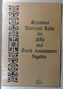
book, E-Gee Printers, Gippsland Electoral Rolls for 1856 and Stock Assessment Payable, 1985
The Electoral Act 1856 was passed through Parliament o March 13, 1856. Victoria was the first Australian colony, and the first legislature anywhere in the world, to adopt the practice of the secret ballot. Victoria's constitution prescribed that the Parliament was to be bicameral, consisting of an upper house, the Legislative Council and a lower house, Legislative Assembly. Men were entitled to vote according to the qualifications described in this book - the right to vote in each house was dependent on status - educational qualifications, income and for either literacy. Two names are registered for the Orbost district: James Dickson and J.C. McLeod.This item is a useful research tool.A 16 pp paper back book which has a clear plastic cover. The covers are beige coloured with the title "Gippsland Electoral Rolls for 1856 and Stock Assessment Payable" in blak print. On the left hand side is a vertical pattern in black print. The book contains an alphabetical list of persons claiming or supposed to be entitled to Vote in the Election of a Member for the District. It lists the needed qualifications of electors followed by the Voters Roll for Legislative Assembly, 1856 and the Voters Roll for Legislative Council, 1856 . It then lists the Stock Assessments, 1856.voting-registers-victoria -
 Greensborough Historical Society
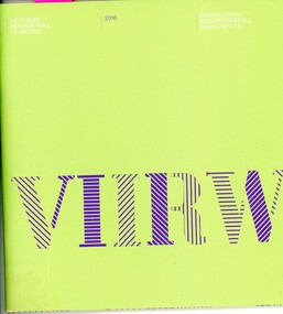
Booklet, Victoria. Women and Royal Commission Branch, Victorian honour roll of women 2016, 2016_03
Lists 20 new inductees into the Victorian Honour Roll of Women in 2016 and outlines the contribution each has made in their area of expertise. Of particular interest is Sherryl Garbutt, former Member for Greensborough in the Victorian Parliament.36 pages, colour illustrationsvictorian honour roll of women, sherryl garbutt -
 Glenelg Shire Council Cultural Collection
Book, Borough of Portland - Acts of Council, 1864
Two volumes. Volume 1 & 2 Red leather bound spine and cover corners. Light red textured covers. Red leather label on centre of front cover with gold text. Gold graphics on spine. Hand written contents page. Contents are acts of Parliament of Victoria relating to Local governmentlocal government, victorian history, council -
 Federation University Historical Collection
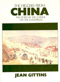
Book, Jean Gittins, The Diggers from China: the story of the Chinese on the goldfields, 1981, 1981
Soft covered book called 'the Diggers from Chine: the Story of the Chinese on the goldfields'. The book is 148 pages and contents include the Celestial empire, the journey, Mountains of gold, Off to the Diggings, Toil and Strife, the way they lived. Appendix A is the report submitted to the Victorian Parliament by the Select committee on the Subject of Chinese Immigration in 1857.chinese, goldfield, lambing flat, immigration, mining, gold, geoffrey blainey -
Bendigo Historical Society Inc.
Document - HARRY BIGGS COLLECTION: OLD POLICE BARRACKS, 25/9/1951
Document. Harry Biggs Collection. A letter from P. T. Byrnes, Minister of Public Works to The Hon. L. W. Galvin, MLA, Parliament House, Melbourne dated 25.9.1951. In the letter P. T. Byrnes is telling The Hon. Galvin that the Education Dept. wants to retain use of the Old Police Barracks.P. T. Byrnes Minister of Public Worksorganization, club/society, community, harry biggs collection, old police barracks -
 Ballarat Tramway Museum
Administrative Record - Meeting Minutes, State Electricity Commission of Victoria (SECV), the SEC and the City of Ballarat and Borough of Sebastopol, Oct. 1929
Demonstrates a consultation process and yields information about the process that saw the eventual take over of the ESCo and MESCo tramways by the SECMinutes - 23 carbon copy foolscap sheets - minutes or transcript of a meeting between the SEC and the City of Ballarat and Borough of Sebastopol 28/10/1929 to regarding the SEC take over and agreements with the locals councils, pending authorisation by Parliament. Sir John Monash led the SEC group Has a list of attendees. trams, tramways, minutes, sec, geelong, ballarat, bendigo, city of ballaarat, borough of sebastopol -
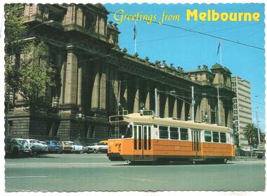 Melbourne Tram Museum
Postcard, Biscay Greetings, "Greetings form Melbourne", c1990
Postcard - serrated edge, featuring Z3 179 in Spring St in front of Parliament House, route 88 destination City. Has on the rear a message to David Webb about a forthcoming tour with tram 661, 41c stamp and cancellation date of 14 May 1990. Biscay Greetings postcard No. BG 148trams, tramways, postcards, z class, spring st, tours, tram 179 -
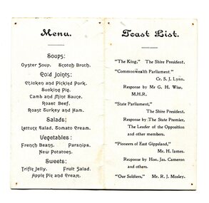 Orbost & District Historical Society
menu, 1916
This event was held on 12th January, 1916 and was held at the Mechanics' Hall. F.A. Nixon was the Shire President. The toast list included toasts to the king, the commonwealth and state parliaments as well as to the pioneers and old soldiers of East Gippsland.This item reflects an event held in Orbost in the early 20th century.A small white menu with black print. On the front are the details of the event, a state parliamentary party dinner with the Orbost Shire emblem at the top. On the back is the menu and the toast list.menu shire-orbost parliamentary-dinner -
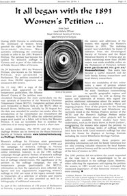 Greensborough Historical Society
Article - Article, Journal, Vicki Court, It all began with the 1891 Women's Petition..., by Vicki Court, 2008_12
Account of the indexing project providing an index to the names and addresses of the women who signed the Women's Petition in 1891, which is available online on the Parliament of Victoria's website. The Women's Petition sought equal voting rights for women.1 p. article from Ancestor, Vol. 29, No. 4, December 2008womens suffrage petition, monster petition, womens suffrage, women's petition 1891 -
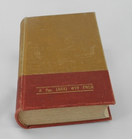 4th/19th Prince of Wales's Light Horse Regiment Unit History Room
Book, Australian Army, Australian Edition of Manual of Military Law 1941
Law manual applicable to Australian Army personnel from 1941. This effectively applied British military law. In 1982 the Defence Force Discipline Act of the Australian Parliament established a framework of military law for Australia's circumstances. Hard cover bookOn front cover in gold lettering- "A Sqn (ARA) 4/19 PWLH" On fly leaf, rubber stamps - "A SQN 1 CAV REGT. Inscription in red ink - "This book is the personal property of ; -J.B.Larkman" and rubber stamp - "WO2 SSM A SQN" On title page - Rubber stamps - "A Sqn (ARA) 4/19 PWLH" and "A SQN 1 CAV REGT" Detailed records of amendments entered in red ink on Amendments pages from Serial 1, 30 Nov 41 to Serial 9, 31 July 1948 military law, world war 2 -
Moorabbin Air Museum
Document (Item) - Copy of the Ansett Letter, The Ansett Letter... Your Reference Copy
Copy of the Ansett Letter, originally sent by Reginald Ansett to all Federal Members of Parliament in order to lay out Ansett's position relative to the Government airline, TAA. Ansett argued his company was at a competitive disadvantage. -
Bendigo Trades Hall Council & Literary Institute Inc.
Book, Parlimentary Debates 20th December, 1916 to 16th March, 1917
Hard Bind Book with pages 10297 - 11708Commonwealth Of Australia, Parliamentary Debates. 20th December, 1916 to 16th March, 1917. VII. George V. Volume LXXXI. Pages 10297 - 11708 and Index. 6th Parliament. 1st Session. Mr Fenton. -
Bendigo Trades Hall Council & Literary Institute Inc.
Book, Parliamentary Debates 18 December 1918 to 6 August 1919
Hard bound book containing pages 9651-11248Commonwealth of Australia Parliamentary Debates 18th December 1918 to 6 August 1919 IX & X George V. Volume LXXXVIII Pages 9651-11248 7th parliament 2nd session Mr Fenton -
Bendigo Trades Hall Council & Literary Institute Inc.
Book, Parliamentary Debates 13th Jan to 22nd Mar 1926
Hard Bind Book with pages 1-1824Commonwealth of Australia Parliamentary Debates. 13th January to 22nd March 1926. 16 George V. Volume 112. Pages 1-1824. 10th Parliament 1st Session (First Period). Mr Fenton -
Bendigo Trades Hall Council & Literary Institute Inc.
Book, Parliamentary Debates 2nd Mar to 24th Mar 1927
Hard Bind Book with pages 1-1085 Commonwealth of Australia Parliamentary Debates. 2nd March to 24th March 1927. 17 George V. Volume 115. Pages 1-1085. 10th Parliament 1st Session (second Period) Mr Fenton -
Bendigo Trades Hall Council & Literary Institute Inc.
Book, Parliamentary Debates 6th Feb to 6th Mar 1952
Hard Binder Book with Pages 1-903 Commonwealth of Australia Parliamentary Debates 6th Feb. to 6th Mar. 1952 Volume 216 Pages 1-903 20th Parliament 1st Session (third period) Hon. P. J. Clarey MP -
 Ballarat Tramway Museum
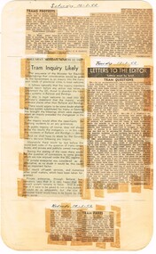
Newspaper, State Electricity Commission of Victoria (SEC) and The Courier Ballarat, Tram Inquiry likely, Mar. 1962
Yields information about the view of The Courier, and locals about the mooted closure of the tramway system and reporting on the proposal in particular local views and the setting up of the Save the Tramway Committee.Foolscap sheet of plain paper, with rounded corners, with 4 newspaper cuttings, concerning the mooted closure of the Ballarat Tram system March 1962. All from The Courier, unless noted otherwise. 1 - "Tram Protests" - 4 letters - 10/3/62 - aged people, lack of a car, Council operated, buses not as good, alternatives 2 - "Tram Enquiry Likely"- Editorial - 12/3/1962 - reporting - government supporting an enquiry, alternatives, Geelong residents, bus operators and private enterprise. 3 - "Tram Questions" - 13-3-62 - set of 2 longer letters - one from an ex Tramwaymen - gives alternative control / operator system and one about political control. 4 - "Tram Fares" - 14/3/62 - would bus operators support the current fare system, pensioners etc - at the time it was an expense to the SEC.closure, letter to the editor, editorial, sec, parliament, fares -
 Ballarat Tramway Museum
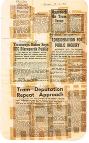
Newspaper, State Electricity Commission of Victoria (SEC) and The Courier Ballarat, Tramways Union says SEC disregards public, Mar. 1962
Yields information about the view of The Courier, and locals about the mooted closure of the tramway system and reporting on the proposal in particular local views and the setting up of the Save the Tramway Committee.Foolscap sheet of plain paper, with rounded corners, with 6 newspaper cuttings, concerning the mooted closure of the Ballarat Tram system March 1962. All from The Courier, unless noted otherwise. 1 - "Note of Warning" - 8/3/62 - from Mr. J J Sheehan regarding loss of jobs. 2 - "Tram Retention" - 8/3/62 - special committee of Council - notes Cr. Roff 3 - "Approach on tram issue" - 8/3/62 - noting that it was the SEC (Bolte) that had suggested the trams go - not Govt. Notes Tom Evans and Mr Scott at meeting. 4 - "Tramways Union says SEC Disregards Public" - 9/3/62 - about a letter from the Union to the Borough of Sebastopol. 5 - "Consideration for Public Enquiry" - 9/3/62 - Minister for Electrical Undertakings Mr Reid, responding to Mr Stoneham, Opposition leader about the proposal to close. 6 - "Tram Deputation Repeat Approach" - 10/3/62 - about a forthcoming meeting of the Save the Trams Committee meeting with the local Parliamentarians, traffic issues with buses to Wendouree.closure, letter to the editor, editorial, sec, parliament, fares -
 Ballarat Tramway Museum
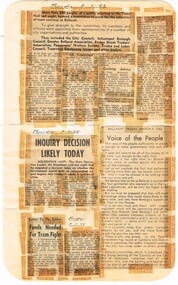
Newspaper, State Electricity Commission of Victoria (SEC) and The Courier Ballarat, Voice of the People, Mar. 1962
Yields information about the view of The Courier, and locals about the mooted closure of the tramway system and reporting on the proposal in particular local views and the setting up of the Save the Tramway Committee.Foolscap sheet of plain paper, with rounded corners, with 5 newspaper cuttings, concerning the mooted closure of the Ballarat Tram system March 1962. All from The Courier, unless noted otherwise. 1 - Untitled report - 8/3/62 - public meeting of 200 people, representatives from a number of bodies, Chair Cr Roff and Mr Courtney - formation of the Save the Trams Committee, including advice from Geelong and City of Launceston running its own transport system. Lists the committee's name. 2 - "Inquiry Decision Likely Today" - 8/3/62 - Quotes Mr Stoneham, Opposition Leader noting recommendation of Sir John Elliot that the MMTB should control all transport in Provincial cities and that Mr Bell Junior had recommended trolley buses. 3 - "Voice of the People" - 9/3/62 - Editorial supportive of public transport, ACT and NT subsidising, united voice. 4 - "Funds Needed for Tram Fight" - 9/3/62 - Cr Roff - seeking funds, not a large amount. 5 - Set of two letters 8/3/62 - about tramway operations, economics and administration.closure, letter to the editor, editorial, sec, parliament, trolley buses -
 Ballarat Tramway Museum
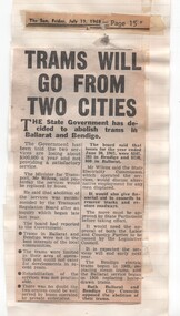
Newspaper, Herald Sun, "Trams will go from two cities", July to Oct 1968
Yields information about the 1968 proposals to close both the Ballarat and Bendigo tramway systems by the state government.Series of newspaper clippings adhered to three quarto lined sheets about the 1968 attempt by the Victorian Government to close the Ballarat and Bendigo tramway systems. .1 - "Trams will go from two cities" - The Sun Friday 19/7/1968, about the Government's decision - gives reasons for the closure. .2 - "Protest over tram protest" - The Sun, 28/8/1968 - with a photo of No. 35 and that the Ballarat Save the Trams Committee not supporting a public protest meeting called by tramway employees. Also has cutting about the State cabinet being delayed by a good train breakdown, a Brisbane train strike and that Country considering the Underground is not vital. .3 - "The Country trams stay" - The Sun Thursday 3/10/1968 - about the Legislative Council not approving the motion to scrap the trams, Labor and Country party combined to defeat the motion. Also cutting on traffic changes to St Kilda Junction. Date of cutting has been taped onto the sheets.closure, ballarat, bendigo, parliament, st kilda junction, sec -
 Ballarat Tramway Museum
Document - Parliamentary 1902, "Electric Trams", 1902
Last page of a report by the Railways Standing Committee 1902. recommends that the State (Victoria) obtains possession of the tramways - looks at the situation in Sydney. At the time Sydney was expanding its electric tram system, Melbourne was reliant on cable trams.Yields information about a view of the Railways Standing Committee in 1902.Photocopy A4 sheet of the last page of a 10 page report dated 6-5-1902, possibly the "Electric Trams" - Parliamentary report - Railways Standing Committee 1902. letters, railways, tramways, reports, public transport, parliament -
 Ballarat Tramway Museum
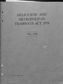
Book, F D Atkinson, Government Printer Melbourne, "Melbourne and Metropolitan Tramways Act 1958 - No. 6311", 1977
Consolidated reprint of the original 1958 Act for the MMTB incorporating amendments up to Act No. 8992, including the Act for the first extension towards Bundoora in 1978. The 1958 Act was a major update of earlier Acts.Demonstrates publishing of Acts of the Victorian Government.Book - 84 pages + cover centre stapled with an additional sheet double sided. Each document have four punch holes.acts, parliament, mmtb, bundoora, tramways, victorian government -
 Melbourne Tram Museum
Newspaper, The Argus, "Railway to Edenhope, Demand for Redgum, use for Road Blocking", 20-1-1927
Provides information on the cost of wood blocking tram tracks in Melbourne with wood blocks - Red gum and Jarrah - part of a Parliamentary enquiry into the construction of a railway to Edenhope. The line was authorised but not built.Yields information about the cost of wood blocks for use in tram tracks.Extract via Trove - 3A4 sheets when printed - Railway to Edenhope, Demand for Redgum, use for Road Blocking" - The Argus 20-1-1927tramways, tram tracks, wood blocks, parliament, edenhope, new railways -
 Melbourne Tram Museum
Document - Personal Papers, H. S McComb, "Consolidation of the Melbourne and Metropolitan Tramways Board Acts", c1955
Set of personal papers - typed carbon copies - various drafts for the fifth and sixth schedules for "Consolidation of the Melbourne and Metropolitan Tramways Board Acts", references to original documents. Includes a comparative table of electric tramways described in part II of the sixth schedule of Act 3732 with the same in the draft of part II of the sixth scheduled for the new consolidation. Proposed alteration to other portions of the MMTB Act of 1928 during consolidation. See Reg Item 2120 for a copy of the Act - 1954 reprint.trams, tramways, mmtb, tramways, parliament, acts of parliament -
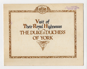 St Kilda Historical Society
Ephemera - Invitation, Visit of Their Royal Highnesses the Duke & Duchess of York, 1927
Invitation from the Commonwealth Government to ceremonies connected with the opening of Parliament House in Canberra on 9 May 1927. Visiting Australia for this purpose were the Duke and Duchess of York (later King George VI and Elizabeth the Queen Mother).Card, folded in half, printed in blue and gold. Affixed inside is a reproduction of a landscape painting Canberra 1927 by Harold B Herbert (1892-1945).The invitation was issued to 'W Nicoll Esq'royal visits, duke and duchess of york, opening of parliament house canberra -
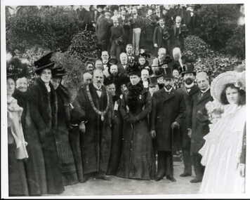 Clunes Museum
Photograph
THE DUKE & DUCHESS OF CORNWALL & YORK - LATER TO BECOME KING GEORGE & QUEEN MARY - DURING THEIR VISIT TO AUSTRALIA IN 1901 FOR THE OPENING OF PARLIAMENT AT FEDERATION. THIS PHOTOGRAPH WAS TAKEN OUTSIDE THE BALLARAR EAST TOWN HALL DURING THE GRAND TOUR..1 FRAMED BLACK AND WHITE PHOTOGRAPH OF THE VISIT TO BALLARAT OF THE DUKE & DUCHESS OF CORNWALL & YORK. .2 - .6 COPIES OF PHOTOGRAPH, VARYING SIZES. ONE LAMINATEDlocal history, photographs, duke and duchess of cornwall & york, federation, 1901 -
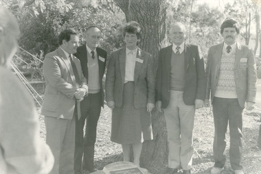 Lakes Entrance Historical Society
Photograph - Johnsonville School, 1986
Five persons named as written on back Barry Murphy Member of Parliament, Jack Froud President Centenary Committee, Val Walton School Council President, Hon. Ian Cathie Minister Education, David Henshaw Headteacher.Black and white photograph of five named people standing behind plaque after the unveiling ceremony at the Centenary Celebrations at primary school Johnsonville Victoriaschools, celebrations -
Federation University Historical Collection
Article - Article - Women, Ballarat Girls' Technical School: Women of Note; Joan Kirner (1938 - 2015)
Joan Kirner was born on the 20th June, 1938, the only child of John Keith Hood and Beryl Edith Cole, whose belief that girls could do anything holds importance in explaining Joan's commitment to improving the status of girls and women Joan graduated from Melbourne University in 1958, and was sent to Ballarat where she taught at the Ballarat Girls' Technical College. Like all women at the time, her marriage to her husband, Ron, a teacher at the Ballarat Junior Technical School in 1960, meant that she was precluded from permanency in the service, an injustice which fueled much of her activism as an education lobbyist and later, as Minister for Education. The birth of three children, and the move back to Melbourne, marked the beginning of Joan's career as a community activist. Joan Kirner's career in politics has two distinctive phases: twelve years in the Victorian Parliament (1982-1994), the remaining decades in community politics. In the Victorian parliament, Joan held the positions of Minister for Conservation, 1985, Minister for Education, 1988, Deputy Premier, 1989, and Victoria's first woman Premier, 1990 to 1992. She retired from parliament in May, 1994. She was a Co-founder of Emily's List which supports women wishing to enter Parliament. Joan Kirner introduced the Victorian Certificate of Education. Awarded Companion of the Order of Australia in 2012 and Centenary Medal in 2001.women of note, joan kirner, joan hood, melbourne university, ballarat girls' technical school, ballarat junior technical school, education lobbyist, minister for education, community activist, victorian parliament, 1982-1994, minister for conservation, deputy premier, first woman premier, emily's list, victorian certificate of education, companion of the order of australia, centenary medal -
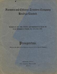 Bendigo Historical Society Inc.
Document - FARMERS AND CITIZENS TRUSTEES COMPANY BENDIGO LTD - PROSPECTUS 1909
Dark grey booklet, A4, 4 pages. On front 'Farmers and Citizens Trustees company Bendigo Limited. Incorporated A.D. 1908 and empowered by Special Act of the Parliament of Victoria ( No 2212) A.D. 1909. Prospectus, filed in the Office of the Registrat General of the State of Victoria. Registered Office, City Chambers, High Street, Bendigo'bendigo, banks, farmers and citizens trustees company -
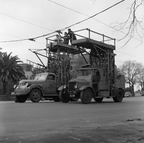 Ballarat Tramway Museum
Negative, Geoff Grant, 19/06/1955 12:00:00 AM
Negative No. N311 and black and white print made by a laser printer (stored in folder ) of the MMTB's tower wagons (the oldest at the time) and No. 2 in Nicholson St. Melbourne, near Parliament House working on a section insulator. Truck No. 2 and Albion No. 8. Negative scanned hi res and imaged updated 21/5/2020.trams, tramways, melbourne, bourke st., nicholson st, tower truck, tram tower wagon