Showing 1809 items matching "planning and development"
-
 Eltham District Historical Society Inc
Slide, Belmont Crescent, Montmorency, c. Mar. 1981
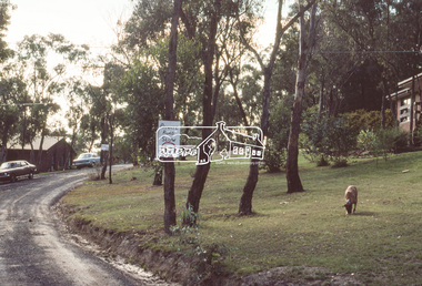
One of a series of images of road infrastructure focussed on Belmont Crescent in Montmorency taken by Eltham Shire Council Planning and Engineering officers. They provide perspective of the changes in housing styles and road development that began sweeping in from the mid 1970s with increasing urbanisation of what was once more outlying suburbs and regions. All images have been identified with GPS35 mm colour positive transparency (1 of 8) Mount - Kodak Kodachrome CardProcessed Mar 1981infrastructure, montmorency, roads, belmont crescent -
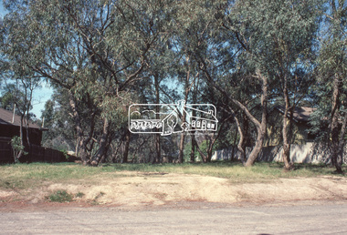
 Eltham District Historical Society Inc
Slide, Belmont Crescent, Montmorency, c. Mar. 1981
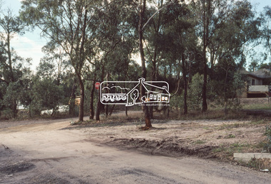
One of a series of images of road infrastructure focussed on Belmont Crescent in Montmorency taken by Eltham Shire Council Planning and Engineering officers. They provide perspective of the changes in housing styles and road development that began sweeping in from the mid 1970s with increasing urbanisation of what was once more outlying suburbs and regions. All images have been identified with GPS35 mm colour positive transparency (1 of 8) Mount - Kodak Kodachrome CardProcessed Mar 1981infrastructure, montmorency, roads, belmont crescent, grand boulevard -
 Hume City Civic Collection
Photograph, c 1978
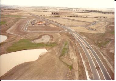
On 4th August 1978 the construction of the Goonawarra Estate commenced. The estate was formerly known as the Goonawarra Farm and overlooked the Sunbury Township and the Jacksons Creek Valley. Plans for the development included a golf course, houses and community and recreational facilities. The golf course opened in 1980 and the housing construction continued throughout the last two decades of the twentieth century and into the twenty first century.A coloured aerial photograph of a display village area under construction. Two lakes are on the LHS of the photograph and Francis Boulevard is in the foreground and the middle distance.goonawarra golf club, goonawarra farm, goonawarra housing estate, housing developments, sharkey, robert b., kilkenny homes, australian ideas homes pty.ltd., glamor homes, craftsmen homes., villa bella homes, george evans collection -
 Hume City Civic Collection
Photograph, c 1978
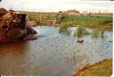
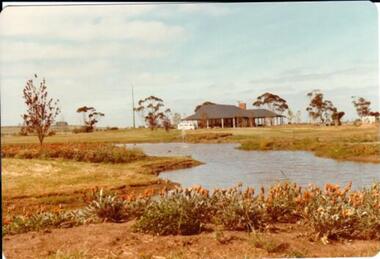
On 4th August 1978 the construction of the Goonawarra Estate commenced. The estate was formerly known as the Goonawarra Farm and overlooked the Sunbury Township and the Jacksons Creek Valley. Plans for the development included a golf course, houses and community and recreational facilities. The golf course opened in 1980 and the housing construction continued throughout the last two decades of the twentieth century and into the twenty first century.A coloured photograph of the reflecting pool at the entrance of the Goonawarra Golf Club. The surrounding area has been landscaped and a display home is in the distance.goonawarra golf club, goonawarra farm, goonawarra housing estate, housing developments, sharkey, robert b., kilkenny homes, australian ideas homes pty.ltd., glamor homes, craftsmen homes., villa bella homes, george evans collection -
 Hume City Civic Collection
Photograph, c 1978
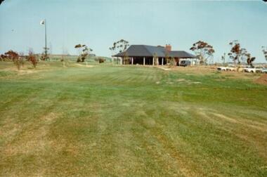
On 4th August 1978 the construction of the Goonawarra Estate commenced. The estate was formerly known as the Goonawarra Farm and overlooked the Sunbury Township and the Jacksons Creek Valley. Plans for the development included a golf course, houses and community and recreational facilities. The golf course opened in 1980 and the housing construction continued throughout the last two decades of the twentieth century and into the twenty first century.A coloured photograph of the clubhouse at the Goonawarra Golf Course taken from the 10th fairway. Parked cars are visible on the RHS of the photograpg and there is a row of gum trees behind the clubhouse.goonawarra golf club, goonawarra farm, goonawarra housing estate, housing developments, sharkey, robert b., kilkenny homes, australian ideas homes pty.ltd., glamor homes, craftsmen homes., villa bella homes, george evans collection -
 Hume City Civic Collection
Photograph, c 1978
On 4th August 1978 the construction of the Goonawarra Estate commenced. The estate was formerly known as the Goonawarra Farm and overlooked the Sunbury Township and the Jacksons Creek Valley. Plans for the development included a golf course, houses and community and recreational facilities. The golf course opened in 1980 and the housing construction continued throughout the last two decades of the twentieth century and into the twenty first century.A coloured photograph of the clubhouse at Goonawarra Golf Course as seen from the 10th green. A small white van is parked ouitside the building. There is a line of trees behind the clubhouse.goonawarra golf club, goonawarra farm, goonawarra housing estate, housing developments, sharkey, robert b., kilkenny homes, australian ideas homes pty.ltd., glamor homes, craftsmen homes., villa bella homes, george evans collection -
 Hume City Civic Collection
Photograph, 1/08/1980
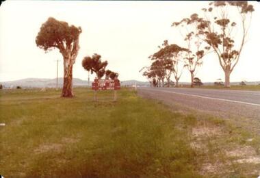
On 4th August 1978 the construction of the Goonawarra Estate commenced. The estate was formerly known as the Goonawarra Farm and overlooked the Sunbury town and the Jacksons Creek valley. Plans for the development included a golf course, houses, community and recreational facilities..The golf course opened in 1980 and the housing construction continued throughout the last two decadesd of the twentieth century and into the twenty firsat century.A coloured photograph showing the signpost indicating the entrance to the Goonawarra Estate from Sunbury Road. Trees are growing on either side of the road and Mt. Holden can be seen across the skyline.goona warra golf club, goonawarra farm, goonawarra housing estate, sharkey, robert b., kilkenny homes, australian ideas homes pty.ltd., craftsmen homes., glamor homes, villa bella homes, mt. holden, george evans collection -
 University of Melbourne, Burnley Campus Archives
Document - Personal files, Andrew Smith's Files, 1981-2022
cactus, cacti, clematis, orchard redevelopment, r. hall, geoff olive, pruning garden, field station, vcah, university of melbourne, burnley, jill kellow, field station redevelopment, field nursery, student gardens, turfgrass, grassy woodland, chris findlay, phil tulk, grasslands, herbaceous border, car park, native garden, restoration native garden, john rayner, hilda kirkhope rockery, herb garden, rainforest garden redevelopment, plant lists, shady walk, salvia, trees, tai-haku cherry, tree management, tree lists, david aldous, grey border -
 Ballarat Tramway Museum
Newspaper, The Courier Ballarat, "Tram site query", 13/05/1972 12:00:00 AM
Newspaper clipping from The Courier, Ballarat, dated Saturday 13/5/1972 titled "Tram site query". Item advising the Ballarat Trades and Labor Council will ask Mr. Tom Evans why the SEC discarded its development plan for the former tram depot site. The TLC Secretary Mr. A. C. Williams spoke about rumours regarding a group of developers interest in the site. One of a large group of newspaper cuttings from John Bainbridge, 7/4/02.sec depot, sale of sec depot -
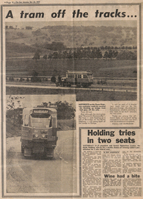 Melbourne Tram Museum
Newspaper, The Sun, “A tram off the tracks”, 22/10/1977 12:00:00 AM
“A tram off the tracks” The Sun, Saturday, Oct 22, 1977 Photos and text Tram # 86 Photos of tram # 86 being transported on semi-trailer on Hume Highway at Beveridge on its way to Orange, NSW. Part of display by Bathurst-Orange Development Corporation, planning to build a new town between the two cities. Trams among the different types of transport being considered to link the proposed town to its neighbours. Tram displays “Brunswick-Moreland Rd” and route number 954.trams, tramways, displays, trucks, z class, transporting trams, tram 86 -
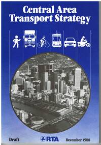 Melbourne Tram Museum
Document - Report, Road Traffic Authority, "Central Area Transport Study", Dec. 1988
Report - 108 pages + card cover, centre stapled, titled "Central Area Transport Study", produced by the Road Traffic Authority as part of the Central Area Transport Strategy (CATS), with a forward by the Minister for Transport Jim Kennan, has a table of contents, figures and tables. Provides a set of Action Plans, looks at future development areas around Melbourne, options, roads, tram and rail lines, cycle and pedestrians. Draft document. See Reg Item 1582 for a March 1991 version.Has pen marks high lighting various paragraphs.trams, tramways, public transport, melbourne, road transport, the met, minister for transport -
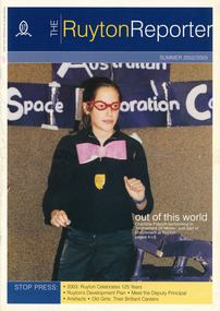 Ruyton Girls' School
Magazine, William Troedel & Co, Ruyton Reporter, 2002
The Ruyton Reporter (formerly known as Ruyton Reports) captures the essential Ruyton Girls' School experience for the broader school community. It has been produced since 1986.The record has strong historic significance as it pertains to one of the oldest girls' school in Victoria, Australia. Ruyton was founded in 1878 in the Bulleen Road, Kew, home of newly widowed Mrs Charlotte Anderson (now High Street South). Thus, the record can be used as a reference example for research into Victorian school history. It also gives insight into the types of activities and events undertaken at Ruyton Girls' School during the period of its production. The record's significance is further enhanced by its exceptionally well-documented provenance, having remained the property of Ruyton Girls' School since its production.Colour publication printed on paper with staple binding. 24 pages.Front Page: PRINT POST APPROVED PP 341999 000226 / R / RECTE ET FIDE LITER / THE RUYTON REPORTER / SUMMER 2002/2003 / out of this world / Charlotte Franich performing in / Tournament Of Minds - just part of / Enrichment at Ruyton: / pages 4+5 / STOP PRESS: 2003: Ruyton Celebrates 125 Years / Ruyton's Development Plan Meet the Deputy Principal / Artefacts Old Girls: Their Brilliant Careers / S4/23 /ruyton girls' school, ruyton, school, students, newsletter, ruyton reports, ruyton news, kew, victoria, melbourne, girls school -
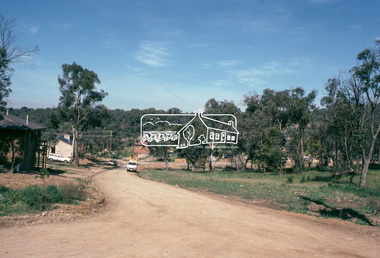
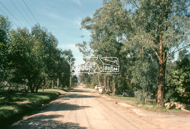
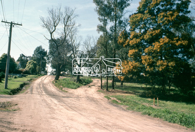
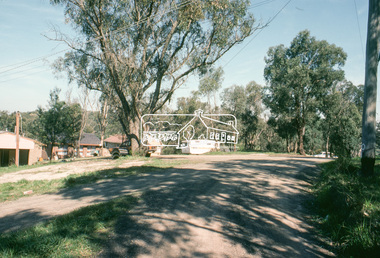
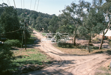
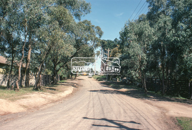
 Eltham District Historical Society Inc
Slide, Quinn Estate, Sackville Street, Montmorency, 15 Sep. 1982
One of a series of images of roads and infrastructure taken by Eltham Shire Council Planning and Engineering officers of the Quinn Estate in Montmorency, Stage 1, Private Street Scheme during construction, September 1982. They provide perspective of the changes in housing styles and road development that began sweeping in from the mid 1970s with increasing urbanisation of what was once more outlying suburbs and regions.35 mm colour positive transparency (1 of15) Mount - Kodak Kodachrome CardProcessed 15 Sep1980housing estate, infrastructure, montmorency, quinn estate, roads, sackville street, private street scheme -
 Eltham District Historical Society Inc
Slide, Quinn Estate, Quinn Way, Montmorency, 15 Sep. 1982
One of a series of images of roads and infrastructure taken by Eltham Shire Council Planning and Engineering officers of the Quinn Estate in Montmorency, Stage 1, Private Street Scheme during construction, September 1982. They provide perspective of the changes in housing styles and road development that began sweeping in from the mid 1970s with increasing urbanisation of what was once more outlying suburbs and regions.35 mm colour positive transparency (1 of15) Mount - Kodak Kodachrome CardProcessed 15 Sep1980housing estate, infrastructure, montmorency, quinn estate, roads, sackville street, private street scheme, quinn way -
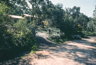
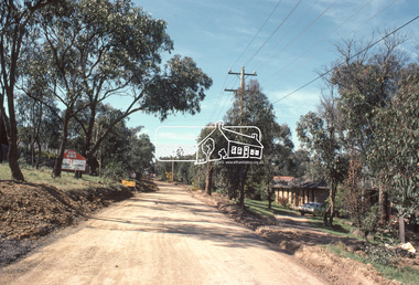 Eltham District Historical Society Inc
Slide, Quinn Estate, Cressy Street, Montmorency, 15 Sep. 1982
One of a series of images of roads and infrastructure taken by Eltham Shire Council Planning and Engineering officers of the Quinn Estate in Montmorency, Stage 1, Private Street Scheme during construction, September 1982. They provide perspective of the changes in housing styles and road development that began sweeping in from the mid 1970s with increasing urbanisation of what was once more outlying suburbs and regions.35 mm colour positive transparency (1 of15) Mount - Kodak Kodachrome CardProcessed 15 Sep1980housing estate, infrastructure, montmorency, quinn estate, roads, private street scheme, cressy street, nicholas lauder real estate -
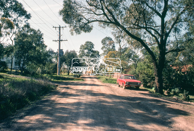
 Eltham District Historical Society Inc
Slide, Quinn Estate, Reichelt Avenue, Montmorency, 15 Sep. 1982
One of a series of images of roads and infrastructure taken by Eltham Shire Council Planning and Engineering officers of the Quinn Estate in Montmorency, Stage 1, Private Street Scheme during construction, September 1982. They provide perspective of the changes in housing styles and road development that began sweeping in from the mid 1970s with increasing urbanisation of what was once more outlying suburbs and regions.35 mm colour positive transparency (1 of15) Mount - Kodak Kodachrome CardProcessed 15 Sep1980housing estate, infrastructure, montmorency, quinn estate, roads, private street scheme, mccarthy grove, reichelt avenue -
 Eltham District Historical Society Inc
Slide, Quinn Estate, Reichelt Avenue, Montmorency, 15 Sep. 1982
One of a series of images of roads and infrastructure taken by Eltham Shire Council Planning and Engineering officers of the Quinn Estate in Montmorency, Stage 1, Private Street Scheme during construction, September 1982. They provide perspective of the changes in housing styles and road development that began sweeping in from the mid 1970s with increasing urbanisation of what was once more outlying suburbs and regions.35 mm colour positive transparency (1 of15) Mount - Kodak Kodachrome CardProcessed 15 Sep1980housing estate, infrastructure, montmorency, quinn estate, roads, private street scheme, reichelt avenue -
 Eltham District Historical Society Inc
Slide, Quinn Estate, Buena Vista Drive, Montmorency, 15 Sep. 1982
One of a series of images of roads and infrastructure taken by Eltham Shire Council Planning and Engineering officers of the Quinn Estate in Montmorency, Stage 1, Private Street Scheme during construction, September 1982. They provide perspective of the changes in housing styles and road development that began sweeping in from the mid 1970s with increasing urbanisation of what was once more outlying suburbs and regions.35 mm colour positive transparency (1 of15) Mount - Kodak Kodachrome CardProcessed 15 Sep1980housing estate, infrastructure, montmorency, quinn estate, roads, private street scheme, buena vista drive -
 Eltham District Historical Society Inc
Slide, Quinn Estate, Reichelt Avenue, Montmorency, 15 Sep. 1982
One of a series of images of roads and infrastructure taken by Eltham Shire Council Planning and Engineering officers of the Quinn Estate in Montmorency, Stage 1, Private Street Scheme during construction, September 1982. They provide perspective of the changes in housing styles and road development that began sweeping in from the mid 1970s with increasing urbanisation of what was once more outlying suburbs and regions.35 mm colour positive transparency (1 of15) Mount - Kodak Kodachrome CardProcessed 15 Sep1980housing estate, infrastructure, montmorency, quinn estate, roads, private street scheme, footpaths and gutters, reichelt avenue -
 Eltham District Historical Society Inc
Slide, Quinn Estate, Reichelt Avenue, Montmorency, 15 Sep. 1982
One of a series of images of roads and infrastructure taken by Eltham Shire Council Planning and Engineering officers of the Quinn Estate in Montmorency, Stage 1, Private Street Scheme during construction, September 1982. They provide perspective of the changes in housing styles and road development that began sweeping in from the mid 1970s with increasing urbanisation of what was once more outlying suburbs and regions.35 mm colour positive transparency (1 of15) Mount - Kodak Kodachrome CardProcessed 15 Sep1980housing estate, infrastructure, montmorency, quinn estate, roads, private street scheme, reichelt avenue -
 Eltham District Historical Society Inc
Slide, Quinn Estate, Reichelt Avenue, Montmorency, 15 Sep. 1982
One of a series of images of roads and infrastructure taken by Eltham Shire Council Planning and Engineering officers of the Quinn Estate in Montmorency, Stage 1, Private Street Scheme during construction, September 1982. They provide perspective of the changes in housing styles and road development that began sweeping in from the mid 1970s with increasing urbanisation of what was once more outlying suburbs and regions.35 mm colour positive transparency (1 of15) Mount - Kodak Kodachrome CardProcessed 15 Sep1980housing estate, infrastructure, montmorency, quinn estate, roads, private street scheme, reichelt avenue -
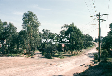
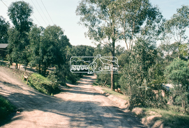
 Eltham District Historical Society Inc
Slide, Quinn Estate, McCarthy Grove, Montmorency, 15 Sep. 1982
One of a series of images of roads and infrastructure taken by Eltham Shire Council Planning and Engineering officers of the Quinn Estate in Montmorency, Stage 1, Private Street Scheme during construction, September 1982. They provide perspective of the changes in housing styles and road development that began sweeping in from the mid 1970s with increasing urbanisation of what was once more outlying suburbs and regions.35 mm colour positive transparency (1 of15) Mount - Kodak Kodachrome CardProcessed 15 Sep1980housing estate, infrastructure, montmorency, quinn estate, roads, private street scheme, mccarthy grove -
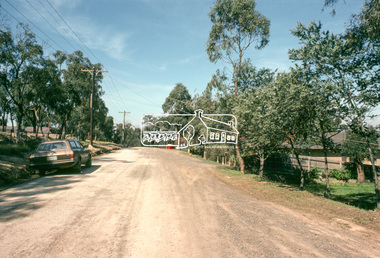
 Eltham District Historical Society Inc
Slide, Quinn Estate, Sackville Street, Montmorency, 15 Sep. 1982
One of a series of images of roads and infrastructure taken by Eltham Shire Council Planning and Engineering officers of the Quinn Estate in Montmorency, Stage 1, Private Street Scheme during construction, September 1982. They provide perspective of the changes in housing styles and road development that began sweeping in from the mid 1970s with increasing urbanisation of what was once more outlying suburbs and regions.35 mm colour positive transparency (1 of15) Mount - Kodak Kodachrome CardProcessed 15 Sep1980housing estate, infrastructure, montmorency, quinn estate, roads, private street scheme, sackville street, t-bowl -
 Eltham District Historical Society Inc
Slide, Quinn Estate, Reichelt Avenue, Montmorency, 15 Sep. 1982
One of a series of images of roads and infrastructure taken by Eltham Shire Council Planning and Engineering officers of the Quinn Estate in Montmorency, Stage 1, Private Street Scheme during construction, September 1982. They provide perspective of the changes in housing styles and road development that began sweeping in from the mid 1970s with increasing urbanisation of what was once more outlying suburbs and regions.35 mm colour positive transparency (1 of15) Mount - Kodak Kodachrome CardProcessed 15 Sep1980housing estate, infrastructure, montmorency, quinn estate, roads, private street scheme, reichelt avenue -
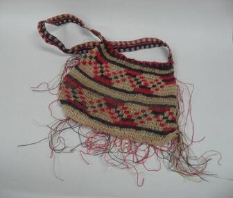
 City of Whittlesea
Accessory (item) - Handbags, Handmade Handbag
In March 2014 Tracey Mallett, Manager Organisation Planning at the City of Whittlesea, represented the City of Whittlesea on a visit to the Buka Urban Council in Bougainville, Papua New Guinea, on behalf of the International Women’s Development Agency. During her trip, Tracey acquired two hand made bags and Shell necklace which she donated to the City of Whittlesea Civic History Collection.handbags, handmade -
 City of Whittlesea
Accessory (item) - Handbags, Handmade, natural dyed fibre Handbag
In March 2014 Tracey Mallett, Manager Organisation Planning at the City of Whittlesea, represented the City of Whittlesea on a visit to the Buka Urban Council in Bougainville, Papua New Guinea, on behalf of the International Women’s Development Agency. During her trip, Tracey acquired two hand made bags and Shell necklace which she donated to the City of Whittlesea Civic History Collection.handbags, handmade -
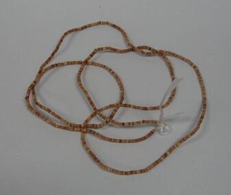 City of Whittlesea
Accessory (item) - Necklaces, Handmade, shell and synthetic fibre necklace
In March 2014 Tracey Mallett, Manager Organisation Planning at the City of Whittlesea, represented the City of Whittlesea on a visit to the Buka Urban Council in Bougainville, Papua New Guinea, on behalf of the International Women’s Development Agency. During her trip, Tracey acquired two hand made bags and Shell necklace which she donated to the City of Whittlesea Civic History Collection.handbags, handmade