Showing 657 items matching "plenty river greensborough"
-
 Greensborough Historical Society
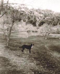
Photograph - Digital image, Old orchard at Partington Flat, 1930c
Remnants of the Partington orchard at Greensborough on land that is now the Partingtons Flat reserve in Greensborough. Charles Partington and family came to Melbourne in the 1840s and moved to Greensborough where they farmed along the Plenty River. This dog belonged to Jessie Partington.Digital copy of black and white photograph.partingtons flat, partington family -
 Greensborough Historical Society
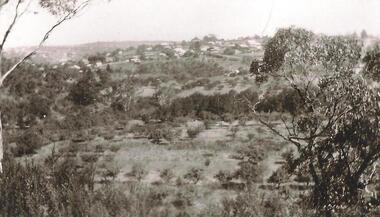
Photograph - Digital Image, Partingtons Flat and Whatmough Park taken from hill, 1930c
The Partington and Whatmough families came to Melbourne in the 1840s and moved to Greensborough where they farmed along the Plenty River. The Partingtons Flat Reserve and Whatmough Park were part of their land holdings and are now Banyule Council owned reserves and sporting fields.Digital copy of black and white photograph.partington family, whatmough family, whatmough park, partingtons flat -
 Greensborough Historical Society
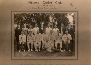
Photograph (copy), Hillcrest Cricket Club: photograph and article, 1931-1932
The Hillcrest Cricket Club is shown in the 1931-32 season. The photograph is named. The photo is accompanied by a handwritten short history of the club by Ray Hooper: "Hillcrest C.C.- Hillcrest Cricket Club was situated between Mountainview Road and … Street at the top of the hill. Where it became flat more or less where River Street met Mountainview Road (straight up). The land was owned by Mr J Ellis (senior) who allowed the local men to make a cricket pitch so they could form a cricket team and enter in the Eltham District Cricket Association (1925-1930). As you can see Mr Ellis Senior (by photo) became president and both his sons played for Hillcrest C.C. My father also played and I can just remember W Mills (Captain), H.Padget, H.Johnson, J.Parks and H.Weidlich (as I got older). Ray Hooper." Copy of group photograph and handwritten article.Group photograph is named.hillcrest cricket club, ray hooper -
 Greensborough Historical Society
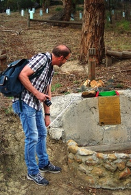
Photograph - Digital image, Marilyn Smith, Unveiling of new plaque at the Pioneer Children's Cemetery, April 2016, 02/04/2016
On 02/04/2016, Greensborough Rotary and Greensborough Hstorical Society members gathered to unveil an updated plaque at the Pioneer Children's Cemetery on the Plenty River. These photos show the new plaque and Steve Whatmough viewing the plaque. Steve is a descendant of the Whatmough family whose children, with their cousins the Partingtons, were buried in this place. More photos of this event can be found at the GHS Resource Centre. Digital copy of colour photograph.greensborough historical society, pioneer childrens cemetery, steve whatmough, rotary club of greensborough -
 Greensborough Historical Society
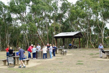
Photograph - Digital image, Marilyn Smith, Blue Lake BBQ, February 2016, 27/02/2016
... Plenty Lower Plenty melbourne Group of Greensborough Historical ...Group of Greensborough Historical Society members at the Blue Lake BBQ in February 2016. Blue Lake is in Yellow Gum Park in the Plenty Gorge. More photos of this event can be found at the GHS Resource Centre.Digital copy of colour photograph.greensborough historical society, plenty river, blue lake, yellow gum park -
 Greensborough Historical Society
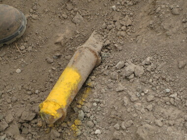
Photograph - Digital image, Dennis Ward, Axle in situ at Partington's Flat, 27/03/2010
... uncovered near the Plenty River trail. From a Greensborough pioneer ...This axle is believed to be from one of the vehicles (possibly a jinker) used by the Partington family on the Willis Vale property. It is shown after being uncovered near the Plenty River trail.From a Greensborough pioneer familyDigital copy of colour photograph.partington family, willis vale -
 Greensborough Historical Society
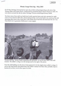
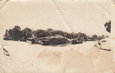
Article, John Gibson, Plenty Gorge Park dig May 2015, 23/05/2015
Account of a dig carried out by Heritage Victoria at the site of the Thomas flour mill, a three-story building with a small cottage built in 1855, which ceased operation in 1863. Article written by GHS member John Gibson.5 p., black text and photographsmoses thomas, flour mill, plenty river -
 Greensborough Historical Society
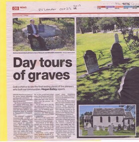
Newspaper Clipping, Diamond Valley Leader, Day tours of graves, 23/10/2013
Dennis Ward talks about his Nillumbik and Banyule cemetery tours in 2013. Includes information on St Helena Cemetery at St Katherine's Church, the Pioneer Children's Cemetery on the Plenty River and the nearby Batman Apple Tree.2 p., text and colour images. 2 copies.dennis ward, st helena cemetery, batman apple tree, cemeteries, pioneer childrens cemetery -
 Greensborough Historical Society
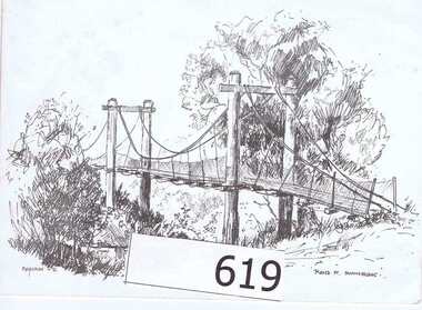
Greeting Card, G E Kerry, Rand Street Swingbridge, 1980c
The sketch portrayed is by Ron Reynolds and was printed the book "Greensborough and Greenhills" in 1973. This is a Christmas greeting to Jessie Angus (nee Partington).The Rand St Swing bridge allowed easy access to Greensborough railway station and shops for those who lived on the eastern side of the Plenty River.A white greeting card made from stiffened card and folded at the left side.A personal greeting to Jessie Angus (nee Partington)written on both inside pages.ron reynolds, jessie angus, partington, rand st, swing bridge, plenty river -
 Greensborough Historical Society
Plan, Plan of Manatunga Circuit Greensborough subdivision, 1970_
Plan of Manatunga Circuit subdivision. Prepared by O'Connor and Beveridge (land surveyors) for Development Underwriting (developers). Plan of subdivision. Part of Crown Portion 3. Parish of Nillumbik, County of Evelyn.An original example of a subdivision plan in the expanding suburb of Greensborough. The 1960s and 1970s saw this area develop from a rural farming area to a suburb.Plan of subdivision. Printed on buff paper, hand coloured. Mounted on cardboard. Includes 2 small cards attached.Various handwritten comments. Small cards from Survey Branch, Office of Titles.greensborough, manatunga circuit, diamond creek road, plenty river drive -
![Article, Memoirs History 1808 -1883 [extract], 1808-1883](/media/collectors/4f729f5697f83e03086015b8/items/51c8f41e2162ef1ef0b051f7/item-media/51c8fab22162ef1ef0b0592f/item-fit-380x285.jpg) Greensborough Historical Society
Greensborough Historical SocietyArticle, Memoirs History 1808 -1883 [extract], 1808-1883
These pages are an extract from "Memoirs History 1808-1883" pages 345-350. This is John Lindsay Beale's account of the formation of the Greensborough Roads Board and Robert William Whatmough's participation on that Board.The Whatmough and Beale families were pioneers in the Greensborough district. This primary source discusses the difficulties of finding a compromise between those living adjacent to the Plenty River and building and maintaining a roadway between Greensborough and Melbourne.4 pages of typed text. An extract from "Memoirs History 1808 -1883" pages 345 - 350.greensborough roads board, beale, whatmough -
 Greensborough Historical Society
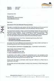
Document, Amendment C78 to the Nillumbik Planning Scheme, 03/09/2012
The planning scheme amendment is to extend protection to a group of Pioneer Children's graves and an historic apple tree.The graves are from the pioneering Whatmough and Partington families. The apple tree is the surviving remnant of a former orchard on the site and is believed to have been purchased from the estate of John Batman.A 16 page collection of documents sent to GHS Committee member Anne Paul regarding an amendment to the Nillumbik Planning Scheme.Niljohn batman, batman apple tree, whatmough, partington, plenty river, pioneer childrens graves, plenty river trail, nillumbik shire council, greensborough, c78 -
 Greensborough Historical Society
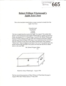
Article, Robert William Whatmough's Apple Tree Chest, 1880_
... of an apple tree washed down the Plenty River to Greensborough in 1878 ...A brief history of Robert Whatmough's apple tree chest as inscribed on paper and attached to inside lid of chest.This chest was made from the trunk of an apple tree washed down the Plenty River to Greensborough in 1878. 1 page of text with line drawingwhatmough, apple tree chest -
 Greensborough Historical Society
Article, History of Batman's Apple Tree, 1835o
This is a timeline of the Apple Tree's history from c1835 to 1966. Information is taken from various printed sources.This is possibly the oldest apple tree in Victoria. It was planted on the banks of the Plenty River in 1841.2 typed pages, 2 copies.apples, john batman, robert whatmough, frederick nevin flintoff, plenty river, batman apple tree -
 Greensborough Historical Society
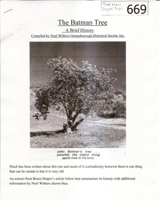
Article, The Batman Tree: a brief history, 1835o
A compilation of information on the Batman Apple Tree collected and written by Noel Withers.This is possibly the oldest apple tree in Victoria. It was planted on the banks of the Plenty River in 1841.5 pages of text and illustrations.batmans apple tree, noel withers, john batman, robert whatmough, frederick nevin flintoff, plenty river, 1841 -
 Greensborough Historical Society
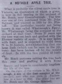
Article, A notable apple tree, 09/04/1910
This article, first published in 1910, reports on the 'old' tree planted near Greensborough.This is possibly the oldest apple tree in Victoria. It was planted on the banks of the Plenty River in 1841.3 pages of text and illustration. First published in "Leader' newspaper Melbourne 1910.batmans apple tree, apples, john batman, robert whatmough, frederick nevin flintoff, plenty river, 1841 -
 Greensborough Historical Society
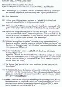
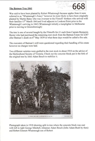
Article, The Batman Tree 1841, 15/03/1841c
Brief history of the early life of the Batman Apple Tree in Greensborough. Compiled in 2011.This is possibly the oldest apple tree in Victoria. It was planted on the banks of the Plenty River in 1841.One page of text and illustration.batmans apple tree, apples, john batman, robert whatmough, frederick nevin flintoff, plenty river, 1841 -
 Greensborough Historical Society
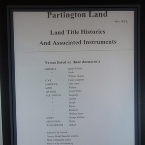
Folder of Documents, Partington land: Land Title Histories and Associated Instruments, 1826o
Land title documents trace the ownership of land owned by the Partington family of Greensborough.The Partington family are Greensborough pioneers and have lived in the area since the 1840s.Folder of copies of land title documents. 36 pages. partington, plenty river, banyule city council, shire of heidelberg, shire of diamond valley -
 Greensborough Historical Society
Article, History of Plenty River Children's Cemetery; by Anne Paul, 1848-1860
The unmarked graves of the children of two Greensborough pioneer families lie in a private cemetery on the Plenty River. Burials occurred between 1848 and 1860.The significance lies in the association with two of the pioneer families of the Greensborough district. Descendants of both families still live in the area.2 printed pages of text, one page map (item 848).pioneer childrens cemetery, plenty river, partington, whatmough -
 Greensborough Historical Society
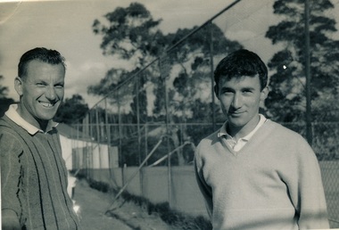
Photograph, Greensborough Tennis Club, 1960s, 1963c
... Tennis Club near Plenty River mid 1960s. Barry's parents lived.... (right). Greensborough Tennis Club near Plenty River mid 1960s ...From caption on back: Photograph of Robert (Bob) Maurer (left) and Barry Keith Taylor, now dec. (right). Greensborough Tennis Club near Plenty River mid 1960s. Barry's parents lived behind the Commercial Bank of Australia in Main Street; Greensborough. He attended Ivanhoe Grammar early 1960s. Very good tennis player.Original photograph of Greensborough Tennis Club players 1960s.Black and white photograph of two men at tennis club.Caption on back of photo.greensborough tennis club, robert maurer, barry keith taylor, rosemary isaacs -
 Greensborough Historical Society
Photograph - Digital image, Charles Marshall et al, View of two small branches of the Nile River, 1917_
Photograph of two small branches of the Nile River, Cairo.Digital copy of black and white photograph"View of two small branches of the Nile Cairo"charles marshall, world war 1, cairo -
 Greensborough Historical Society
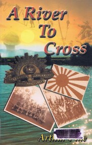
Book, Indra Publishing et al, A River to cross, by Arthur Pike, 2001_
A fictional account of an Australian soldier's memories of World War II and his travels to Japan 50 years later.Paperback, 222p.world war 2 -
 Greensborough Historical Society
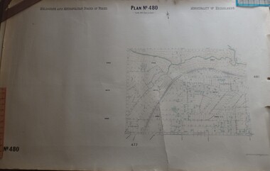
Map, Melbourne & Metropolitan Board of Works, MMBW Plan No.480, 17/10/1949
... MMBW plan of part of central Greensborough, from Plenty... Greensborough, from Plenty River in North to Grimshaw Street in South ...MMBW plan of part of central Greensborough, from Plenty River in North to Grimshaw Street in South, Sellars Street in West to Kerr Street in East.Map shows buildings and topography for the area.MMBW plan, black and colour ink on beige parchment, 4 copies."Scale:160 feet to 1 inch"melbourne and metropolitan board of works, mmbw, greensborough -
 Greensborough Historical Society
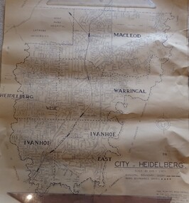
Map, City of Heidelberg. Engineers Dept, City of Heidelberg, 1960s
Map of the City of Heidelberg from the Yarra River in the South to North of Watsonia Military Camp. Shire of Diamond Valley is shown to the north.Map showing municipal and ward boundaries, black text on light brown paper."Scale: 20 CHS = to 1 IN"city of heidelberg -
 Greensborough Historical Society
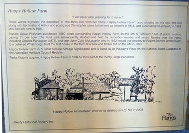
Photograph - Digital Image, Happy Hollow plaque, 24/10/2006
Photograph of details on the Happy Hollow plaque and descendants of past owners of Happy Hollow unveiling the commemorative plaque. This plaque was laid by Plenty Historical Society. Digital copies of 3 colour photographs.happy hollow, plenty river, john mclaughlin, charles partington, robert emmett whatmough, parks victoria -
 Greensborough Historical Society
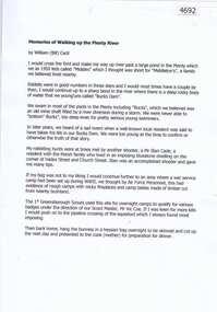
Document, Bill Cecil, Memories of walking up the Plenty River, by William (Bill) Cecil, 1950o
Bill Cecil remembers activities from his youth including rabbit hunting on the Plenty River1 page, typescriptplenty river, bill cecil -
 Greensborough Historical Society
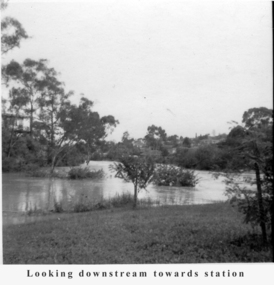
Photograph - Digital Image, Tony Fitton, Plenty River flood 1960s, 1960s
The Plenty River in flood, 1960s. Photos taken by Tony Fitton. Digital copy of black and white photographs.Captions on imageplenty river, floods -
 Greensborough Historical Society
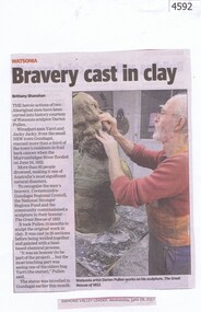
Newspaper Clipping, Diamond Valley Leader, Bravery cast in clay, 28/06/2017
The heroic actions of two Aboriginal men have been carved into history courtesy of Watsonia sculptor Darien Pullen.News article 1 page, black text, colour image.watsonia, aboriginal, murrumbidgee river flood, darien pullen -
 Greensborough Historical Society
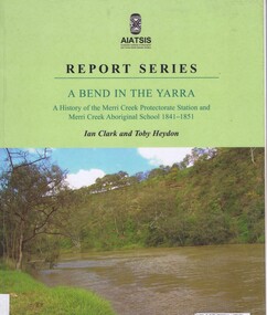
Book, Ian D. Clark et al, A Bend in the Yarra: a history of the Merri Creek protectorate Station and Merri Creek Aboriginal School 1841-1851, by Ian D. Clark and Toby Heydon, 2004_
A history of Aboriginal cultural institutions in colonial Victoria, in this book the interaction between Wurundjeri people and government officials and settlers at the confluence of the Merri Creek and Yarra River.Paperback book, 90 p. black & white illusmerri creek, aborigines victoria -
 Greensborough Historical Society
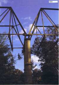
Photograph, Maroondah aqueduct pipe bridge 2011, 2011_
in 1891 the Watts River (near Healesville) was tapped. It supplied water to Melbourne, via the Maroondah aqueduct. The Maroondah Reservoir, northeast of Melbourne, was completed in 1927 and water was piped via the Maroondah aqueduct to the northern suburbs. It was replaced by large pipes in the 1980s. Parts of the aqueduct structure remain.Copy of colour photographaqueduct pipe bridge greensborough, maroondah aqueduct