Showing 2158 items
matching reef
-
 Bendigo Historical Society Inc.
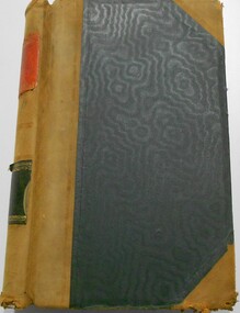
Document - MCCOLL, RANKIN AND STANISTREET COLLECTION: NAPOLEON REEF GOLD MINE CO NL SHARE REGISTER
Share register, green cover and buff spine and corners. 'Share register' and " Napoleon Reef Gold Mine Co. NL" printed on spine. Alphabetical index of shareholders in front of book. Dates from 1940 - 1941 on entries.business, mining, napoleon reef gold mine nl -
 Bendigo Historical Society Inc.
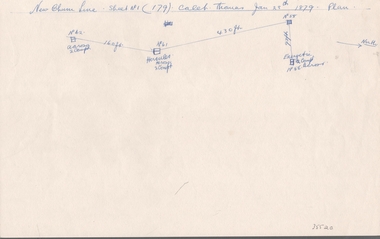
Document - NEW CHUM LINE OF REEF - SKETCH OF MINES ALONG THE NEW CHUM LINE OF REEF
Sketch of mines along part of the New Chum Line Of Reef. Sheet No 1 (179). Caleb Thomas Jan 28th 1879. Plan. Hercules and Energetic Mines on drawing, 430 feet apart. Albert Richardson Collectiondocument, gold, new chum line of reef, sketch of mines along the new chum line of reef, hercules, energetic, caleb thomas -
 Stawell Historical Society Inc
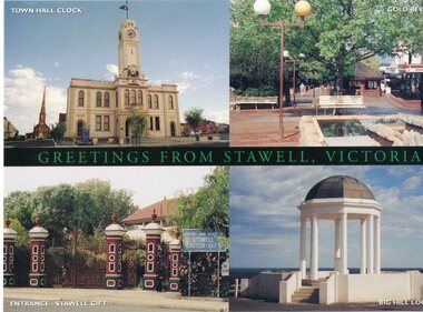
Postcard, postcard with 4 views of stawell
Town Hall Stawell, Gold Reef Mall, Central Park Gates, Big Hill MemorialPostcard showing four views of StawellStawellstawell -
 Torquay and District Historical Society
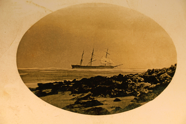
Photograph - Photograph (copy), Scammel Collection
Photo shows the Joseph H Scammel stranded on the reef off Point Danger Torquay in 1891One of the many ships wrecked on the coast of southern Victoria.Sepia photographshipwrecks great ocean road victoria -
 Ballarat Heritage Services
Photograph - Digital photographs, L.J. Gervasoni, Hooded Plovers Flying, Killarney Beach, 2015, c2015
Killarney Beach is located at the end of Mahoney's Road. It is sheltered from wave action by offshore reefs. Colour photograph of Hooded Plovers flying at Killarney Beach, Victoria. killarney beach, killarney, beach, coast, ocean, hooded plovers, birds, flying, seascape -
 Ballarat Heritage Services
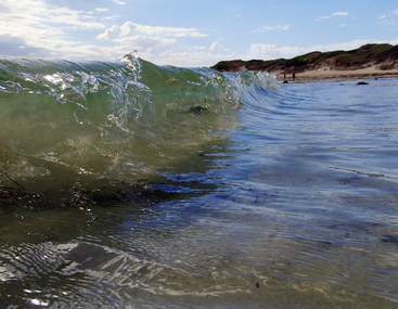
Photograph - Digital photographs, L.J. Gervasoni, Wavelet at Killarney Beach, 2016, c2016
Killarney Beach is located at the end of Mahoney's Road. It is sheltered from wave action by offshore reefs. Colour photograph of a wavelet at Killarney Beach.beach, wave, killarney, killarney beach, killarney, victoria, coast, ocean, seascape, landscape -
 Ballarat Heritage Services
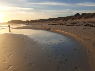
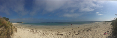
Photograph - Photograph - Colour, Clare Gervasoni, Killarney Beach, Victoria, 26/12/2019
Killarney Beach is located at the end of Mahoney's Road. It is sheltered from wave action by offshore reefs. Panoramic photograph of Killarney Beach, Victoria.killarney beach, coast, beach -
 Ballarat Heritage Services
Photograph - Photograph - Colour, Clare Gervasoni, Killarney Beach, Victoria, 26/12/2019
Killarney Beach is located at the end of Mahoney's Road. It is sheltered from wave action by offshore reefs. Colour photograph of Killarney Beach, Victoria.killarney beach, coast, beach -
 Ballarat Heritage Services
Photograph - Photograph - Colour, Clare Gervasoni, Killarney Beach, New Year's Eve, 2016, 31/12/2016
Killarney Beach is located at the end of Mahoney's Road. It is sheltered from wave action by offshore reefs. A number of beach scenes at dusk showing Killarney Beach. killarney beach, seaside, new year's eve, beach -
 Ballarat Heritage Services
Photograph - Photograph - Colour, Killarney Beach, 2016, 24/12/2016
Killarney Beach is located at the end of Mahoney's Road. It is sheltered from wave action by offshore reefs. Colour photograph of Killarney Beachkillarney beach, seaside, coastal -
 Bendigo Historical Society Inc.
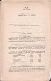
Document - GARDEN GULLY LINE OF REEF, LEASE BLOCKS 5360 AND 5361
Two page document titled ' Report on lease blocks Nos. 5360 and 5361 Garden Gully line of reef, Bendigo. Produced by the Department of Mines 1899. The area described is about 'one mile and a quarter southeast from the centre of the city of Bendigo, immediately south of the Great Southern Gold Mining Company's workings and is intersected by two auriferous gullies ... Salomon's Gully and Derwenter's Gully'. The alluvial deposits, the Garden Gully line, the Great Souther Co.and old workings are discussed in the paper. A map of the Garden Gully line of reef is attached to the report, showing claimholders and mine names along that section of the reef. Mines named on the map: Great Southern Garden Gully United Ulster Londonderry Burrows Horwoods Sea Amalgamated Garden Gully United Victory and Pandora Unity Carlisle and Garden Gully and Passbye United Cornish United Koch's PioneerJames Stirling, Government Geologistbendigo, mining, garden gully line of reef mines -
 Federation University Historical Collection
Book, Report on the Little Bendigo or Nerrena Gold-Field, Ballarat, 1901, 1901
Blue soft covered foolscap book of 4 pages. The book includes a folded, colour contour plan shewing reefs and Surface Works Little Bendigo Gold Field and an Underground Survey of Mines, Metropolitan, Monte Cristo Linelittle bendigo, nerrena, h.s. whitelaw, william baragwanath, geology, monte christo, monte cristo, neerena, nerrina, plans, mining cgt -
 Bendigo Historical Society Inc.
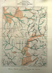
Map - STRUGNELL COLLECTION: HUSTLER'S LINE OF REEFS, BENDIGO, September 1913
Map, Hustler's Line of Reefs, Great Extended Hustler's Mine Plan,Plate No X (10).Bulletin No 33 Signed H.A.Whitelaw Underground survey Office Bendigo September 1913 Drawing has a table showing depths of levelsUnderground Survey Office, Bendigo.map, bendigo, great extended hustler's mine -
 Bendigo Historical Society Inc.
Map - STRUGNELL COLLECTION: HUSTLER'S LINE OF REEFS, BENDIGO, September 1913
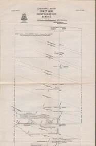
Map, Hustler's Line of Reefs, Comet Mine, Longitudinal Section.Plate No.XXV1 (26).Bulletin No 33 Signed H.A.Whitelaw Underground survey Office Bendigo September 1913 Drawing shows the vertical shaft descending to over 1692 feetUnderground Survey Office, Bendigo.map, bendigo, comet mine -
 Bendigo Historical Society Inc.
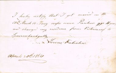
Document - ANCIENT ORDER OF FORESTERS NO. 3770 COLLECTION: CORRESPONDENCE
Note from Lorenz Valentine mentioning that got married on 30th March 64 and his wife's name was Pauline. He also changed his residence from Victoria reef to Sparrowhawk Gully. Dated April 20th 1864.societies, aof, correspondence, ancient order of foresters no. 3770 collection - correspondence, pauline valentine, lorenz valentine -
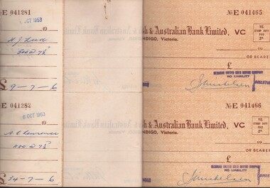 Bendigo Historical Society Inc.
Document - MCCOLL, RANKIN AND STANISTREET COLLECTION: NAPOLEON REEF/DEBORAH UNITED - CHEQUE BOOK, 1953/59
Document: Double height cheque book from 'The English, Scottish & Australian Bank Limited, with the first section stamped Napoleon Reef Gold Mining Co and folded - Rear section stamped Deborah United Gold Mining Co.MCCOLL RANKIN & STANISTREETorganization, business, gold mine accounting., mccoll rankin & stanistreet -
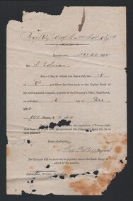 Bendigo Historical Society Inc.
Document - BARKLY REEF GOLD MINING COMPANY SHARE ACCOUNT, 1875
Document. Barkly Reef Gold Mining Company Share Account to J Dolman dated 22 Nov 1875 being for 100 shares for the above named company. Document is signed by Hay?, Manager. Document is printed by Gillingham, Eaglehawk.cottage, miners, barkly reef gold mining company share account, j dolman, hay, gillingham eaglehawk -
 Bendigo Historical Society Inc.
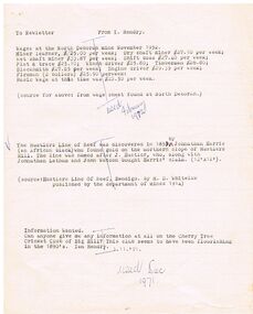
Document - WAGES AT THE NORTH DEBORAH MINE NOVEMBER 1952
Typed notes detailing the wages of various mine workers and also the Basic Wage at the time. Also mentions the discovery of the Hustlers Reef by Johnathan Harris and if anyone can give information on the Cherry Tree Cricket Club of Big Hill.document, typed notes detailing the wages of various mine workers and also the basic wage at the time. also mentions the discovery of the hustlers reef by johnathan harris and if anyone can give information on the cherry tree cricket club of big hill. typed notes detailing the wages of various mine workers and also the basic wage at the time. also mentions the discovery of the hustlers reef by johnathan harris and if anyone can give information on the cherry tree cricket club of big hill. -
 Bendigo Historical Society Inc.
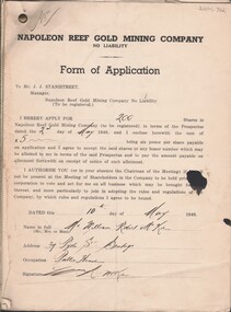
Document - MCCOLL, RANKIN AND STANISTREET COLLECTION: NAPOLEON REEF GOLD MINING CO. N.L, May 1940
Documents: 46 pages Form of Application for shares in Napoleon Reef, addressed to Mr J.J. Stanistreet (Manager) from the prospectus dated 2nd May 1940, signed and dates from 1 May 1940 - 14 May 1940.organization, business, industrial - mining, mccoll rankin & stanistreet, mining, gold mining, napoleon reef -
 Bendigo Historical Society Inc.
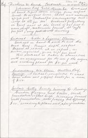
Document - MCCOLL, RANKIN AND STANISTREET COLLECTION: NEW MONUMENT GMC N/L - QUOTATION FOR SUPPLY OF MINING TRUCKS, 16/2/1939
Document. 2 letters to Mr Mooney and plans for mining truck. Mr Andrew Mooney Monument Hill Co on the front of the folder. Also 3 reprints from the Bendigo Advertiser 'Work on Inner Reef at Central Deborah' in the folder.McColl, Rankin & Stanistreetorganization, business, new monument gmc n/l, mccoll, rankin & stanistreet, new monument gmc n/l, monument hill company, gold mining, quotation for mining trucks, mr a mooney -
 Bendigo Historical Society Inc.
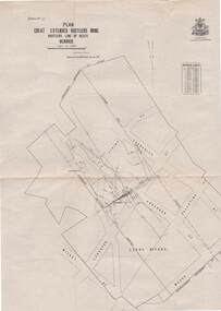
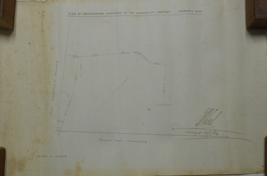
Plan - MARKS COLLECTION: PLAN OF UNDERGROUND WORKINGS CINDERELLA COMPANY, JOHNSON'S REEF
Plan on heavy parchment paper: on top of plan 'Plan of the underground workings Cinderella Company, Johnson's Reef' Lh side of plan 'Kent Company's Ground' on bottom: Tipper and Company. Written on bottom surveyed 13/7/64.bendigo, mining, cinderella company -
 Bendigo Historical Society Inc.
Map - COMET MINE - PLAN OF COMET MINE
Plan of the Comet Mine on the Hustler's Line of Reefs Bulletin No 33, Plate No XXIV signed by H S Whitelaw, Underground Survey Office Bendigo, September 1913. Upper and Lower Levels and approximate boundaries shown. Depths shown.Geological Survey of Victoriamining, parish map, hustler's line of reefs, comet mine plan bulletin no 33 plate no xxiv -
 Moorabbin Air Museum
Document (Item) - Ansett South Molle Island Advertisement, South Molle Island
Provides information about Ansett's packaged holidays on South Molle Island, near the Great Barrier Reef. -
 Ballarat Heritage Services
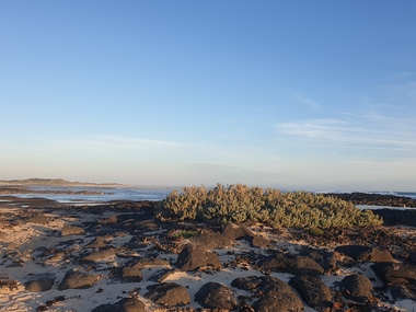
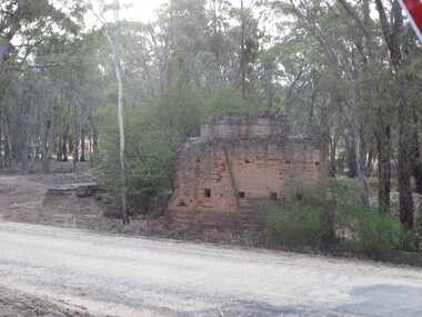
Photograph - Photograph - Colour, Steele's Pioneer Mine Ruins, Yandoit, 2016, 18/01/2016
Steele's Reef was opened in 1859 along with a number of other reefs in the Yandoit area. The reef was worked by small mining parties until the late 1880s. In 1887, the Steele's Reef Quartz Mining Company fixed steam pumping machinery and commenced sinking a shaft. The company were unable to find a profitable ore body and after two years work closed down. By this time their shaft had reached a depth of 150 feet. The mine was then taken over by the Pioneer Quartz Mining Company who appear not to have worked the mine. In 1906, the Steele's Pioneer Company commenced work, erecting a winding winch at the old shaft sunk by the Steele's Company. The next year the company erected a 10-head battery, set of poppet legs, a pumping engine. Sinking the shaft a further 100 feet, the company struggled to find payable ore and soon closed down.Colour photographs of the remnants of Steele's mine at Yandoit, Victoria. steele's mine, yandoit, mining, ruins -
Bendigo Historical Society Inc.
Map - HUSTLER'S & CHRISTMAS LINES OF REEFS - PLAN OF LINES OF SECTION OF REEFS
Underground Survey of Mines Bendigo. Plan of Cross Section Lines Shewing Connections with Trigonometrical Stations and Base Lines. 13/3/99 Signed ? Stirling. Places and mines mentioned Speciman Hill, Tambour Major, Lansell's 180, Victory and Pandora, Great Extended Hustler's, Windmill Hill on Victoria Reef. Next part of map is a Plan of Lines of Section between the Hustler's and Christmas Lines of Reefs. 8/3/99. Signed ?. Transverse Section. Shows Tambour Major Co., near the Christmas Line of Reef, Crosscuts and their depth, geological features and stone encountered. Then shows Thistle Line, Charshalton Line, Napoleon Line, Nell Gwynne Line, New Chum Line, Lansell's No 180 with levels, depths and geological features. Drawing is continued in three parts to fit on paper. Lansell's East Shaft with levels and depths, geological features and stone encountered. Sheepshead Line, Old Shaft, Garden Gully Line, Victory and Pabndora Co with crosscuts, depths, geological features and stone encountered. Paddy's Gully Line, Derby Line, Millers Line, Hustler's Line, Great Extended Hustler's Co with levels, depths, geological features and stone encountered. A note beside a Saddle Reef: 360,000 pounds paid in dividends from this reef. Average ounces per ton gold noted where found. Reference Table for stone and geological features. Datum Line 700 feet above Sea Level Unscannedmining, parish map, hustler's & christmas lines of reefs, plan of lines of section of reefs, ? stirling, specimen hill, tambour major, lansell's 180, victory & pandora, great extended hustler's, windmill hill, victoria reef, tambour major co, christmas line, hustler's line, thistle line, carshalton line, napoleon line, nell gwynne line, new chum line, lansell's no 180, lansell's east shaft, sheepshead line, old shaft, garden gully line, paddy's gully line, derby line, miller's line, hustler's line, great extended hustler's co -
 Bendigo Historical Society Inc.
Book - H. A & S. R. WILKINSON COLLECTION: SHARE REGISTER BOOK
Leather bound share register book. On the front inside page a note in pencil: given by Cath Ferguson - Balmoral Drive - 03/07/1998 to James Lerk, also a stamp McDonald's Reefs Gold Mining Company No Liability. The book has 243 pages the first 56 pages are cut. Company recorded in the book are: New Charscharlton (?), New Chum Syncline, Central Napoleon, Ironbark South, Central Deborah. South Virginia, New Don, Castley Syndicate, Napoleon Reefs, Deborah Limited. The book covers the years from 1934 to 1940. -
 Bendigo Historical Society Inc.
Document - ALBERT RICHARDSON COLLECTION: MINING CONTRACTS
One page document with information from Dickers Mining Records, Contracts 23.11.1861, page 15. Mine listed are Johnson Reef Gold Mines Co. To put down a winze to 305 feet level. Contract for carting away tailings, contract for putting in x cut and materials. Gibbs and Lazarus Claim, contract to sink the cut East Reef; Londonderry Co's Claim contract to erect horse and poppet heads; Sailors Gully Quartz Mining Co., erection of engine and boiler, brick foundation 15 ft high, fixing bob of pump.bendigo, mining, mining contracts -
 Bendigo Historical Society Inc.
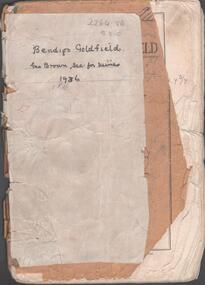
Booklet - Albert Richardson Collection: Bendigo Goldfield, MInes Department, Victoria 1936, 1936
Albert Richardson was an expert on the history of the Bendigo Goldfield. The Albert Richardson Park at Victoria Hill, is named in his honour. He was a prominent member of the Bendigo Historical Society. Fifty one page booklet. On front page: Bendigo Goldfield, issued by Geo Brown, Secretary for Mines, under the authority of The Hon. E.J. Hogan, M.L.A., Minister of Mines. Mines Department, Melbourne, Victoria, Australia, 1936.Content includes: historical information; recent development and future prospects, geology and lines of reef. Reef lines described are: Tysons, Lightning Hill, Hustlers, Derby, Paddy's Gully, Garden Gully, Deborah, Sheepshead, New Chum, Nell Gwynne, British and Foreign, Napoleon, Lancashire, Carshalton, Thistle, Christmas and Birds. On front cover 'Bendigo Goldfield, Geo Brown, Sec. for Mines, 1936' written in black pen. On first page 'A.Richardson, 29 Harrison Street, Bendigo' The booklet is annotated throughout by Albert Richardson, for example, the mines along the New Chum Line are further described with their date of formation, sill heights and area of claim.albert richardson, gold mining, goldfield, reef lines, 1936 -
 Bendigo Historical Society Inc.
Map - HUSTLER'S REEF NO 1 MINE - TRANSVERSE SECTION OF THE HUSTLER'S REEF NO 1 MINE
Map of a transverse Section of the Hustler's Reef No 1 Mine on the hustler's Line of Reefs Bulletin No 33, Plate No XXI. Map shows poppet legs at 801.07 feet above Sea Level and drawing of shaft with the different levels. Also shown are geological features and stone encountered. Geological Survey of Victoria emblem H Herman, Director, W Dickson, Secretary of Mines and The Hon. J. Drysdale Brown MLC Minister of Mines. Signed by H S Whitelaw, Underground Survey Office Bendigo, September 1913. This item has not been scanned or photographed.mining, parish map, hustler's reef no 1 mine, hustler's line of reefs, geological survey of victoria, underground survey office bendigo, h s whitelaw, h herman, w dickson, the hon j drysdale brown -
 Bendigo Historical Society Inc.
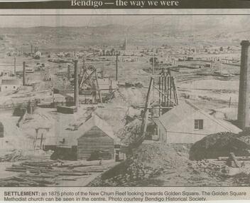
Newspaper - JENNY FOLEY COLLECTION: SETTLEMENT
Bendigo Advertiser ''The way we were'' from 2000. Settlement: an 1875 photo of the New Chum Reef looking towards Golden Square. The Golden Square Methodist church can be seen in the centre. Photo courtesy Bendigo Historical Society.newspaper, bendigo advertiser, the way we were