Showing 576 items matching "route map"
-
 Melbourne Tram Museum
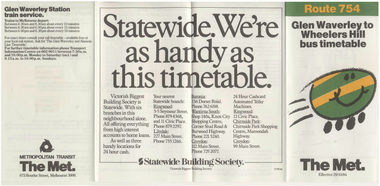
Ephemera - Timetable, Metropolitan Transit Authority (MTA), Bus Route 754, Glen Waverley to Wheelers Hill, Oct. 1984
... . Provides a map, description of route, time points, timetable.../1984. Provides a map, description of route, time points ...Printed fold out timetable for Bus Route 754, Glen Waverley to Wheelers Hill, published by The Met, effective 29/10/1984. Provides a map, description of route, time points, timetable, ticketing information (Travel cards and Neighbourhood tickets) and the Glen Waverley Railway station and train service. Has a sponsored advert by the Statewide Building Society. Has logos of the Met. Folded into four.trams, tramways, tickets, the met, bus services, timetables, neighbourhood tickets -
 Melbourne Tram Museum
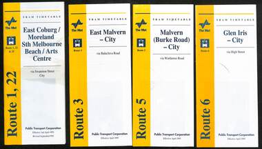
Ephemera - Timetable, Public Transport Corporation (PTC), Set of 24 The Met tram timetables, 1995
... / Moreland Sth Melbourne Arts centre tram service, Route 1 and 22... Transport Corporation. Provides a map, description of route, time ...Set of 24 The Met Public Timetables.Demonstrates tram timetables published by The Met during 1995..1 - Printed 20 page book stapled timetable for East Coburg / Moreland Sth Melbourne Arts centre tram service, Route 1 and 22, dated April 1995. The "The Met" logo, was published by the Public Transport Corporation. Provides a map, description of route, time points, timetable, ticketing information, some ticketing information, introduction by the relevant Depot, including a photo - and an image of a tram available for hire as a party tram. .2 - Route 3 - East Malvern - City - April 1995 .3 - Route 5 - Malvern (Burke Road - City - April 1995 .4 - Route 6 - Glen Iris - City - April 1995 .5 - Route 8 - City - April 1995 .6 - Route 11 - City - April 1995 .7 - Route 11 - City - Nov. 1995 .8 - Route 12 - Sth Melbourne Beach and St Kilda Beach - City - April 1995 .9 - Route 16 - St Kilda Beach - City - April 1995 .10 - Route 19 - North Coburg - City - Nov 1994, revised 8/1995 .11 - Route 48 - North Balwyn - City - 30/4/1995, revised 9/1995 .12 - Route 64 - East Brighton - City - April 1995 .13 - Route 64 - East Brighton - City - Nov. 1995 .14 - Route 67 - Carnegie - City - April 1995 .15 - Route 67 - Carnegie - City - August 1995 .16 - Route 69 - Kew Cotham Road - St Kilda Beach - April 1995 .17 - Route 70 - Wattle Park - City - April 1995 .18 - Route 72 - Camberwell - City - April 1995 .19 - Route 75 - East Burwood - City - April 1995, revised 8/1995 .20 - Route 78/79 - North Richmond - St Kilda Beach or Prahran - April 1995 .21 - Route 86 - Bundoora - City - Oct 1995. .22 - Route 109 - Port Melbourne - Mont Albert April 1995 .23 - Route 109 - Port Melbourne - Mont Albert August 1995 .24 - La Trobe St Service - City - East Melbourne April 1995trams, tramways, tickets, the met, tram services, timetables, route 69, route 1, route 22, route 3, route 5, route 6, route 8, route 11, route 12, route 16, route 19, route 48, route 64, route 72, route 75, route 78, route 79, route 86, la trobe st - east melbourne, route 67, route 70, route 109 -
 Melbourne Tram Museum
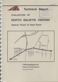
Document - Report, TTM Consulting, "Evaluation of North Balwyn Fairway, Balwyn Road to Harp Road", May. 1985
Approx a 70 page, comb bound, report by TTM Consulting in May 1985, titled "Evaluation of North Balwyn Fairway, Balwyn Road to Harp Road" for the Public Transport Corporation. Evaluates the impact of a Fairway along the North Balwyn tram route. Principal conclusions given on page - tram travel times in both AM and PM peaks were virtually unchanged. Document has many tables at rear, graphs and maps.Stamped on cover and inside page "Discarded from PTC Library 19 Oct 1989" and "1985" in red ink on front cover.trams, tramways, north balwyn, fairways, traffic control, tram priority -
 Melbourne Tram Museum
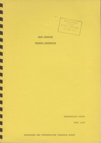
Document - Report, Melbourne & Metropolitan Tramways Board (MMTB), "East Preston Tramway Extension - Feasibility Study July 1976", Jul. 1976
Ninety three page, plus yellow covers, plastic cover on front and bound with a brown coloured comb binder report titled "East Preston Tramway Extension - Feasibility Study July 1976", by the MMTB. Looks at the costs, construction, operating cots, revenue, proposals considered and patronage for the extension of the East Preston tramway in various stages. Has a number of maps, figures, tables, plans, property acquisition, extension to Preston Institute of Technology, road layouts, bus routes and analysis of costs.Stamped on cover and inside page "Discarded from PTC Library 19 Oct 1989".trams, tramways, east preston, mill park, latrobe university, tramway proposals, mmtb -
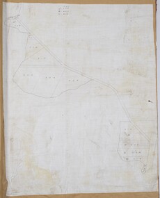 Bacchus Marsh & District Historical Society
Map, Lerderderg Gorge Road Goodmans Creek to Gisborne Road
The date of this map and its purpose has not been established. It was possibly produced to indicate landholders who were impacted by works along the Lerderderg Gorge Road. A single page paper map showing various blocks of land along the route of the Lerderderg Gorge Road near Bacchus Marsh from Goodmans Creek to the point where the road joins with Gisborne Road. The map is pasted into a bound volume containing 76 maps or plans in total. High resolution digital image stored on BMDHS computer network. bacchus marsh victoria maps, lerderderg gorge road bacchus marsh maps -
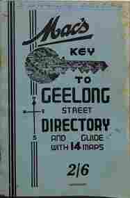 Ballarat Tramway Museum
Map, A W Hedley, McHardy's Publications, "Mac's key to Geelong Street Directory", late 1930s
Geelong Street Directory - "Mac's Key to Geelong", 14 maps, giving a directory of streets, suburb listing and abbreviations, Municipal and Public offices of Government departments and a list of Justices of the Peace. Shows the tram routes and rail lines. Has many advertisements for Geelong businesses or products. Possibly late 1930s as map 1 does not show the line to the Beach.Yields information about Geelong suburbs and businesses, late 1930sPrinted booklet - 40 pages + card cover, centre stapled.On front cover "To be retained in D/S's Office" in ink and on page 1 "Ex B. Weedon with thanks"tramways, geelong, maps -
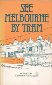 Ballarat Tramway Museum
Book, de Lacy Lowe et al, "See Melbourne by Tram", 1982
Book titled "See Melbourne by Tram" written by de Lacy Lowe, illustrated by Ceri Vaughan, published 1982. Gives a description of 22 Melbourne tram routes with a stop description (not all stops covered) and sketches associated with the location. Has an index in the rear pages.Yields information about Melbourne Trams, their routes and what to see in 1982.Book - 160 pages + card cover with maps on inside covers.Has a handwritten gift notation of 1982 on page 2.trams, tramways, melbourne, tram routes, tram stops, tourist guides, illustrations -
 Moorabbin Air Museum
Booklet (Item) - Ansett-ANA Information and Route Maps Customer Handouts - Souvenir Flight Folders
... Booklet Ansett-ANA Information and Route Maps Customer ... -
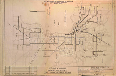 Ballarat Tramway Museum
Map, State Electricity Commission of Victoria, "Geelong & Suburbs Showing Bus Routes and former Tramway Routes", 19-3-1968
... Map or drawing titled "Geelong & Suburbs Showing Bus Routes ...Map or drawing titled "Geelong & Suburbs Showing Bus Routes and former Tramway Routes", dated 19-3-1968, SEC Drawing No. VD6/144A.Demonstrates an SEC document showing a comparison between Geelong tram routes and the 1968 bus routes.Map or drawing No. VD6/144A, folded into 3.tramways, secv, geelong, buses, maps -
 Bendigo Historical Society Inc.
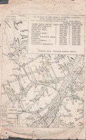
Document - MINING REPORTS - MAP OF PART OF THE BENDIGO GOLDFIELD INCLUDING WHITE HILLS AND EAGLEHAWK
BHS CollectionMap of part of the Bendigo Goldfield including White Hills and Eaglehawk. Map shows reef lines, gullies, railway line, tram route, type of rock, name of mine, Calls and Dividends. Also Deepest Mine Victoria Quartz 4614 ft. Names of Mines are Garden Gully United, Great Ext'd Hustlers, Johnson's Reef, South New Moon, New Moon, Catherine Reef, Virginia, Central Red White & Blue, Ironbark, Kock's Pioneer, Carlisle and the Hercules & Energetic. Map is part of the Albert Richardson Collection of mining documents and research. document, gold, mining reports, mining reports, map of part of the bendigo goldfield including white hills and eaglehawk, pabst bendigo goldfield, garden gully united, great ext'd hustlers, johnson's reef, south new moon, new moon, catherine reef, virginia, central red white & blue, ironbark, kock's pioneer, carlisle, hercules & energetic. victoria quartz -
 Bendigo Military Museum
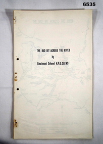
Journal - Royal Australian Survey Corps - The Bad Bit Across the River - LtCol HPG Clews 1934, LTCol HPG Clews RASvy, 1934
... of party members on foot. The map shows the routes taken.... of party members on foot. The map shows the routes taken. Royal ...This Journal "The bad bit across the River" was written by - LtCol HPG Clews in 1934 and is about his experiences around the Colo River approximately 60 miles NW of Sydney, NSW. LtCol Clews was a remarkable man and his achievements were just as remarkable. He is affectionately known as "The Major." He served in the British Army 1909 - 1911 with the Sherwood Foresters. He then served in the Royal Australian Survey Corps from 1912 - 1949 and then served as the Senior Surveyor with the Snowy Mountains Authority from 1950-1958. A Survey Cairn is errected in Khancoban to record his life 1890 - 1980. This Journal records the field trip to establish Survey Control in very rugged country by a handful of party members on foot. The map shows the routes taken.14 x foolscap pages stapled and two hole punched. The Journal includes a map, 7 x pages of typed text and 4 x Annexesroyal australian survey corps, rasvy, fortuna, army survey regiment, army svy regt, asr, 2nd field survey company -
 Ballarat Tramway Museum
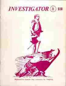
Document, John M Moore, "Investigator" - Geelong Historical Society - Geelong Tramways, 1983
1 - Investigator Journal of the Geelong Historical Society - issue 54 - March 1979 with an article on Geelong Street names 2 - ditto - issue 71 - with a detailed article on the formation history of Geelong Trams by John M Moore including photos. Establishment of MESCo, J J Jobbins, construction, tracks, buses, practical jokes, map, trams and decorated cars. Also has an article about Geelong Stret names 3 - Scan of issue 72 - Continued from item 2 - route descriptions, 1930s improvement, WW2, tram cars, staff changes, with photos. Report on the closure of the Geelong Tramway System in March 1956, including the presentation of conductor's bells from tram 23 to Cr Camereon and the Mayor of Geelong Cr Fidge. Gives notes on the replacement bus services, events of the last trams and those involved on the day such as Driver Stanley Parker and Conductor Eric Sweetten. See item 9117 for a bell presented to Depot Foremen S Irwin.Yields information about the history of Geelong tramways and its operations.Two copies of the Geelong Historical Society journal "investigator" Nos. 54 and 71 - printed A5 centre stapled and one A4 copy of issue 72 article on Geelong tramways.tramways, state electricity commission of victoria, geelong, tramcars, secv, closure, mesco -
 Victorian Railway History Library
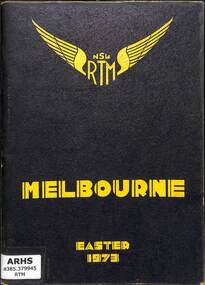
Book, The New South Wales Rail Transport Museum, Melbourne Easter 1973, 1973
A tour program detailing the route and travel information for the special train from Sydney to Melbourne with 3801 and 3820 run by the New South Wales Rail Transport Museum over the Easter holidays in 1973.maps, p.52.non-fictionA tour program detailing the route and travel information for the special train from Sydney to Melbourne with 3801 and 3820 run by the New South Wales Rail Transport Museum over the Easter holidays in 1973.railroad preservation - victoria - history, tourist trains - victoria - history -
 Ballarat Tramway Museum
Administrative record - Book, Andersons' printing, "Ballaarat Tramways", Jan. 1888
Book with an index or table of contents, listing all the documents relating to the establishment of the Ballaarat Tramways (the horse tram operator) including, references to Legislation and orders in council, original tender conditions, the contract between the Council and Edward Thomson, Specifications for the construction, delegation to the operator, and plan of routes. Last document dated 17/1/1888.Yields information about the establishment of the Ballarat horse trams, Councils and the operator.Bound book, with end papers, 20 pages, patterned covers, titled with a label on the front cover - "Ballaarat Tramways"Has an old ownership note on the inside front cover.secv, tramways, horse trams, city of ballaarat, ballaarat tramway company, tenders, specifications, operations, maps -
 Bendigo Historical Society Inc.
Map - BENDIGO BUS ROUTES, 1934 - 1958 ?
... Map: Bendigo bus Routes, State Electricity Commission... Bus Routes Map: Bendigo bus Routes, State Electricity ...Map: Bendigo bus Routes, State Electricity Commission of Victoria, Electricity Supply Department. Printed on the bottom right hand corner F.E.B 23-12-47 , R.L.A. 5-9-58, 19-9-34, 27-11-37. 4 Mapsmap, bendigo, transport, state electricity commission, bendigo bus routes -
 Narre Warren and District Family History Group
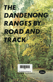
Book, Sandra Bardwell, The Dandenong Ranges by Road and Track, 1981
Tour routes in the Dandenong Ranges, including maps.64 p.; 22 cmnon-fictionTour routes in the Dandenong Ranges, including maps.dandenong ranges, tourism, cardinia reservoir, emerald lake park, aura vale lake, crystal brook park, bimbimbie wildlife park, guidebook -
 Falls Creek Historical Society
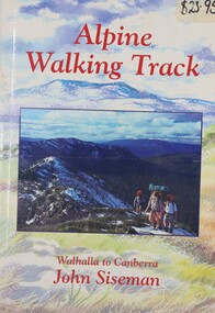
Book - Alpine Walking Track - Walhalla to Canberra, John Siseman, 1993
A guide for travellers of the Alpine Walking Track which stretches 750 kilometres through three major alpine nationals parks, ascends the highest mountains in Victoria, New South Wales and the Australian Capital Territory. It features information about alternative routes and side trips. and is illustrated, with maps and photographs.A light hearted look at the world of skiing featuring cartoons.non-fictionA guide for travellers of the Alpine Walking Track which stretches 750 kilometres through three major alpine nationals parks, ascends the highest mountains in Victoria, New South Wales and the Australian Capital Territory. It features information about alternative routes and side trips. and is illustrated, with maps and photographs.alpine walking track, bushwalking, walhalla -
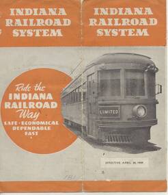 Ballarat Tramway Museum
Ephemera - Timetable, Indiana Railroad, "Indiana Railroad system, Timetable, April 30, 1939" - Wal Jack Collection, Apr. 1932
Eight page (folded) timetable for the Indiana Railroad (Interurban Traction Co.) in receivership at time (see page 2), map of page 1, showing routes and connecting lines, bus services, services, days run etc. Record images added 20/8/2013.On each timetable in pencil, whether traction operated or bus (coach), where coach, crossed out in pencil.indiana railroad (electric cars), indianapolis, terre haute, timetables -
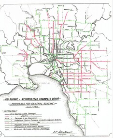 Melbourne Tram Museum
Poster, Association of Railway Enthusiasts (ARE), "General Scheme for Future Tramways", 1998
Laminated A3 poster or sheet titled "General Scheme for Future Tramways", prepared by the Association of Railway Enthusiasts in 1998 extracted from the MMTB Annual Report for 1923. Has comments on the scheme, new lines, proposals and shows the lines proposed. Map shows cable lines, existing electric lines, tramways proposed to be abandoned (Rathdowne St), Domain Road, alternative routes, railways and railway tram routes. Includes a photo of tram 105. 2nd copy - not lamined - folded into three vertically. See also Reg Item 2089 for an original of this document.trams, tramways, mmtb, general scheme, new track, closure, construction, routes, tram 105 -
Ballarat Tramway Museum
Document, State Electricity Commission of Victoria (SECV), "Evidence to be given at the inquiry into Public Transport Facilities at Ballarat", 4/1968
Details the history of the Ballarat system, take over by the SEC and the conditions of that take over by the SEC, reconstruction, financial losses incurred by the SEC, decline in passengers, its suitability, condition of the infrastructure and rolling stock. Its unsuitability to extend, effectiveness of the Geelong conversion, ability of private bus operators, tramway employees, methods of abandonment, tram tracks, overhead and impact on the electricity supply system. Dated 2/4/1968. Has a table showing the income and losses and population from 1935 to 1967, a coloured graphical presentation of tramway statistics, sheet of Fares and Charges for Ballarat. Attached to the rear of the document was an advertisement for Ballarat Tramways fare sections (See Reg Item 8039) and a map showing tram and bus services - drawing No. VX4/1/1. Attached to the second copy is drawing VD6/144, showing Geelong bus routes and former tram routes. See item 8038 for the Bendigo document dated May 1968. Yield information and demonstrates the SEC's attitude to trams in Ballarat and their finances. Report, 13 foolscap pages + three attachments stapled on left hand side, titled "Evidence to be given at the inquiry into Public Transport Facilities at Ballarat" Two copies held.secv, ballarat, trams, tramways, sec, reports, closure, history, buses, submissions -
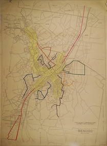
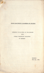 Ballarat Tramway Museum
Document - Report, State Electricity Commission of Victoria (SECV), "Evidence to be given at the inquiry into Public Transport Facilities at Bendigo", May. 1968
Details the history of the Bendigo system, take over by the SEC and the conditions of that take over by the SEC, reconstruction, financial losses incurred by the SEC, decline in passengers, its suitability, condition of the infrastructure and rolling stock. Its unsuitability to extend, effectiveness of the Geelong conversion, ability of private bus operators, tramway employees, methods of abandonment, tram tracks, overhead and impact on the electricity supply system. Has a table showing the income and losses and population from 1935 to 1967, a coloured graphical presentation of tramway statistics, sheet of Fares and Charges for Ballarat. Attached to the rear of the document was an advertisement for Ballarat Tramways fare sections (See Reg Item 8039) See item 9835 for the Ballarat report dated April 1968. At the rear of the second copy is drawing VX4/2/1 showing bus and tram routes in Bendigo and VD6/144A for Geelong. See Reg Item 8046 for a separate map which may have been part of this report.Yield information and demonstrates the SEC's attitude to trams in Bendigo and their finances.Report 15 Foolscap sheets, duplicated and three attachments, was stapled in the top left hand corner, titled "Evidence to be given at the inquiry into Public Transport Facilities at Bendigo" Presented 28/5/1968. Two copies held.trams, tramways, reports, closure, bendigo, history, buses, submissions -
 Melbourne Tram Museum
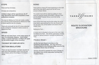
Document, Yarra Trams, "Route 70 Deviation Brochure", 5/1999
Document issued to crews at the time of the opening of the Batman Ave Deviation in June 1999. Pamphlet dated 31/5/1999. Wikipedia Reference for the route dates the use from 6/6/1999. Has a map, notes on the tram stop, speed, section insulators and the siding. Published by Yarra Trams.Demonstrates a Yarra Trams pamphlet at the time of the relocation of route 70 from the Batman Ave terminus to its operation via Flinders St and the Exhibition St bridge.Document - or pamphlet - titled "Route 70 Deviation Brochure" - A4 sheet, 3 fold DL.tramways, route 70, yarra trams, new tramways, batman ave, new track -
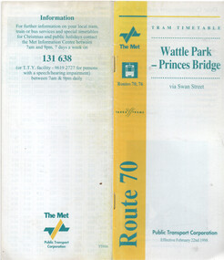 Melbourne Tram Museum
Ephemera - Timetable - route 70 - Wattle Park - Princes Bridge, The Met, 2/1998
... as well, and PTC name on the rear cover. Has a map of the route... as well, and PTC name on the rear cover. Has a map of the route ...Timetable - route 70 - Wattle Park - Princes Bridge, dated 22/2/1998, published by The Met, with Yarra Trams logo as well, and PTC name on the rear cover. Has a map of the route, forward by Geoff Lockwood Operations Supt of Camberwell depot, the Met Fare system, an advert for tram hire, timing points, and contact information.Demonstrates a timetable at the time of the formation of Yarra Trams when it was operated by The Met and the PTC.Timetable - printed, centre stapled, 24 pages.tramways, timetables, route 70, wattle park, the met, yarra trams -
 Victorian Railway History Library
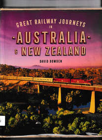
Book, Bowden, David, Great Railway Journeys in Australia & New Zealand, 2017
A look at 35 trips that highlight some of the most interesting, scenic and rewarding railway journeys in Australia and New Zealand. They include the renowned long-distance journeys, such as The Indian Pacific in Australia that takes travellers on a three-day trip from Perth to Sydney or the The Northern Explorer in New Zealand’s North Island that stretches from Wellington to Auckland, as well as those that traverse stunning scenery, such as New Zealand’s TranzAlpine train or the Spirit of the Outback in Australia. There are also routes on which restored steam locomotives operate and other lines included for the wonder of their engineering. Trains are a great way to travel in these countries, taking you at ground level past superb scenery that often cannot be seen by any other means of transport. David Bowden’s entertaining text describes the route, the major features of interest along the way and any special technical details about the locomotive or the track.index, ill, maps, p.157.non-fictionA look at 35 trips that highlight some of the most interesting, scenic and rewarding railway journeys in Australia and New Zealand. They include the renowned long-distance journeys, such as The Indian Pacific in Australia that takes travellers on a three-day trip from Perth to Sydney or the The Northern Explorer in New Zealand’s North Island that stretches from Wellington to Auckland, as well as those that traverse stunning scenery, such as New Zealand’s TranzAlpine train or the Spirit of the Outback in Australia. There are also routes on which restored steam locomotives operate and other lines included for the wonder of their engineering. Trains are a great way to travel in these countries, taking you at ground level past superb scenery that often cannot be seen by any other means of transport. David Bowden’s entertaining text describes the route, the major features of interest along the way and any special technical details about the locomotive or the track.railroad travel - australia, railroad travel - new zealand -
 Victorian Railway History Library
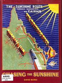
Book, Burke, David, Chasing The Sunshine: The Sunshine Route Through Queensland to Cairns, 2009
A history of the building of the railway from Brisbane to Cairns in Queensland.index, ill, maps, p.154.non-fictionA history of the building of the railway from Brisbane to Cairns in Queensland.railroad construction - australia - history, railroad construction - queensland - history -
 Phillip Island and District Historical Society Inc.
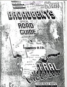
Booklet, Broadbent's Official Road Guide incorporating Central Victoria 55th Edition, About 1951
... contains maps, plans of routes, a detailed description of roads... contains maps, plans of routes, a detailed description of roads ...These are only the pages relevant to Phillip Island from the guide. Broadbent's Official Road Guides Company took over George R. Broadbent's business in 1935. In 1963, it changed its name to Broadbent's Road Maps Pty. Ltd. Each Victorian guide contains maps, plans of routes, a detailed description of roads, mileage, hotels, garages, guesthouses, shops etc.HistoricalFoolscap sized, black and white photocopied pages stapled into booklet.broadbent's guides, guesthouses, shops, hotels, rothsay guesthouse, cowes main garage, co-operative society, hislop's newsagency, wagner's butchery, the nobbies tea rooms -
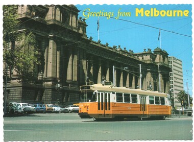 Melbourne Tram Museum
Postcard, Biscay Greetings, Z3 179 outside Parliament house, c1990
Postcard - serrated edges, with title "Greetings from Melbourne", featuring a photograph of Z3 179 outside Parliament house, c1990. Tram fitted with a trolley pole running a route 88. Produced by Biscay Greetings, postcard BG 148, with a map of Australia and the location of Melbourne marked. Divided back with space for stamp and address. 2nd copy added 30/8/2020trams, tramways, z3 class, parliament, route 88, spring st, tram 179 -
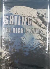 Falls Creek Historical Society
Book - Skiing the High Plains, Harry Stephenson, 1982
... is accompanied by a map of the route and photos taken along the way ...This history of the Ski Exploration of Victoria's Alpine Area contains descriptions of all the great pioneering tours of the 1920s and 1930s as recorded and documented by members of those parties at the completion of their trips. Every tour story is accompanied by a map of the route and photos taken along the way. This is an historic document, recapturing and recording achievements by the pioneers who cut the first ski tracks across our Alpine Winter Wonderland, and whose names are a "Who's Who" of the earliest years of Victorian skiing. In addition, this book contains sections of superb full-page photographs of the mountains in winter, taken by noted Australian mountain skier-photographers.The extensive volume of 432 pages including maps and photographs. The endpapers include maps of the High Plains. A dedication and acknowledgements are included and it has been signed by the author. This history of the Ski Exploration of Victoria's Alpine Area contains descriptions of all the great pioneering tours of the 1920s and 1930s as recorded and documented by members of those parties at the completion of their trips. Every tour story is accompanied by a map of the route and photos taken along the way. This is an historic document, recapturing and recording achievements by the pioneers who cut the first ski tracks across our Alpine Winter Wonderland, and whose names are a "Who's Who" of the earliest years of Victorian skiing. In addition, this book contains sections of superb full-page photographs of the mountains in winter, taken by noted Australian mountain skier-photographers. high plains history, history of skiing victoria, bogong high plains -
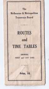 Melbourne Tram Museum
Map, Melbourne & Metropolitan Tramways Board (MMTB), "Routes and Time tables showing first and last cars", c1927
Folded map (5 x 3) by Melbourne and Metropolitan Tramways Board, c1927, of Melbourne tramways, showing tram routes (cable, electric and VR), railway lines, major points of interest and major streets. Titled "Routes and Time tables showing first and last cars". On rear shows maps of lines for the Eastern, Southern, Connection to Beaches and the Essendon, Maribyrnong and West Coburg lines. Dated c1927, shows the St Kilda Road lines to electric. On the bottom right hand corner has a reference to the Tramway Tourist Car - and the tours it does. (Reg Item 800 dated March 1927, shows the tram under construction). Second copy from Keith Kings Collection - in poor condition - added 10/8/2017The VR line has various hand written notations indicating it.trams, tramways, map, mmtb, tourist trams, y class, vr, cable trams, routes, timetables -
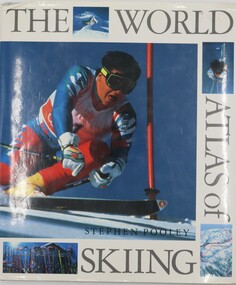 Falls Creek Historical Society
Book - The World Atlas of Skiing, Stephen Pooley, 1990
Skiing is the most exhilarating and popular winter sport in the world. The number of skiers has expanded every year since the advent of cheaper travel in the 1960s and an increased affluence brought a new group of ski enthusiasts to the slopes. The professional sport has also expanded and attracts a very large television audience. The World Atlas of Skiing looks at over 50 of the most prestigious and beautiful ski resorts in the world. From the older and more established destinations, like St Moritz, Gstaad, Kitzbühel, and St Anton in the Alps, and the chic American resorts of Aspen, Vail and Jackson Hole, to the huge, new custom-built skiing areas such as the Trois Vallees and Val d'Isere in Europe and Taos and Ski the Summit in the U.S. The continuing expansion of the sport has meant that one can ski in most parts of the world from Scotland and Russia to Australia, New Zealand and India. Each resort is illustrated with specially commissioned artworks which show the runs - from the nursery slopes to the most demanding which only the most experienced skiers attempt - ski lifts, cable cars as well as other distinctive features, such as the langlauf routes. The history and events of international championships - Winter Olympics or World Cup - that have given particular character to the resort are described, as well as the skiing greats who have mastered them.A volume of 190 pages including a table of contents, index, photographs and maps describing popular ski resorts around the world. It is divided into sections of Europe, The Americas and The Rest of the World.non-fictionSkiing is the most exhilarating and popular winter sport in the world. The number of skiers has expanded every year since the advent of cheaper travel in the 1960s and an increased affluence brought a new group of ski enthusiasts to the slopes. The professional sport has also expanded and attracts a very large television audience. The World Atlas of Skiing looks at over 50 of the most prestigious and beautiful ski resorts in the world. From the older and more established destinations, like St Moritz, Gstaad, Kitzbühel, and St Anton in the Alps, and the chic American resorts of Aspen, Vail and Jackson Hole, to the huge, new custom-built skiing areas such as the Trois Vallees and Val d'Isere in Europe and Taos and Ski the Summit in the U.S. The continuing expansion of the sport has meant that one can ski in most parts of the world from Scotland and Russia to Australia, New Zealand and India. Each resort is illustrated with specially commissioned artworks which show the runs - from the nursery slopes to the most demanding which only the most experienced skiers attempt - ski lifts, cable cars as well as other distinctive features, such as the langlauf routes. The history and events of international championships - Winter Olympics or World Cup - that have given particular character to the resort are described, as well as the skiing greats who have mastered them.skiing travel books, ski resorts of the world