Showing 3062 items matching "scales"
-
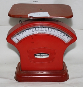 Southern Sherbrooke Historical Society Inc.
Persinware 501 kitchen scales
Red metal scales. Square shaped dish. Dial weighs up to 16oz. Has knurled knob for adjustments.On dial says "To weigh 16oz by 1/8oz" and "domestic use only" -
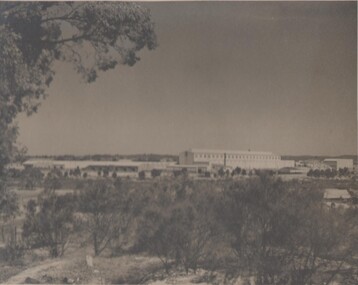 Bendigo Historical Society Inc.
Photograph - BENDIGO ORDINANCE FACTORY COLLECTION: LARGE SCALE VIEW OF THE DEVELOPMENT OF THE ORDINANCE FACTORY SITE, 1950s
large scale photograph covering the full development of the Ordinance Factory site Black & white photo, large format -
 University of Melbourne, Burnley Campus Archives
Plan, Bundoora Extended Care Centre, 1996
South View to Building, Section Elevation by Karin Smith dated 01.06.1996, p3 of 3. Scale 1:50.karin smith, bundoora, bundoora extended care centre -
University of Melbourne, Burnley Campus Archives
Plan, Victorian College of Agriculture and Horticulture Small Residential Landscape, 1980-1990
Tracing paper Concept Drawing by John Doe Number 1/3. Scale 1:250. (2 sheets)landscape design, residential -
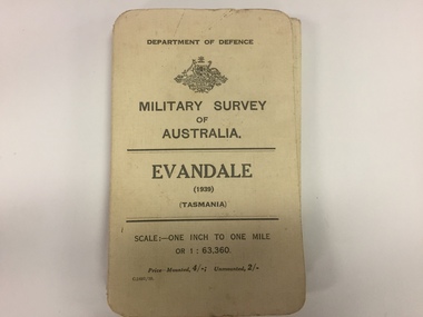 The 5th/6th Battalion Royal Victoria Regiment Historical Collection
Map, Military Survey of Australia. Evandale (1939) (Tasmania), 1939
Fabric backed colour map, with card cover that folds into a small book. Scale one inch= one mile.military, survey, map, tasmania, ww2, wark vc club -
Glenelg Shire Council Cultural Collection
Plan - Plans / Line drawings - Port of Portland Authority, Portland Harbour Trust Commissioners Fishermen's breakwater, Victoria, 05/03/1974
PORT OF PORTLAND AUTHORITYFront: '3' black texta, top right corner -
Glenelg Shire Council Cultural Collection
Plan - Plans / Line Drawings - Port of Portland Floor Plan layout and footings Marine Department depot, Victoria, n.d
PORT OF PORTLAND AUTHORITYFront: '6' black texta, top right corner -
Glenelg Shire Council Cultural Collection
Plan - Plans / Line Drawings - Port of Portland Authority Slipway Vessel 'Atlantic Clipper', Portland, Victoria, 11/11/1986
PORT OF PORTLAND AUTHORITYFront: 'Deadline PM. WED 3rd DEC JOB NO 3008' BLACK PEN, BOTTOM LEFT '20' - black texta, top right corner -
University of Melbourne, Burnley Campus Archives
Plan, Melbourne Girls College, 1980s?
Coloured, laminated, Concept Plan for Courtyard between Portables and East Elevation Main Building. Scale 1:100. Student: Redna Moore, on reverse.melbourne girls college, redna moore, students, courtyard -
University of Melbourne, Burnley Campus Archives
Plan, Gerner Sanderson Faggetter Cheesman, Hay's Paddock, 1981
Sketch Plan dated September 1981, by Gerner Sanderson Faggetter Cheesman, Drawing No 200.01. Scale 1:100.gerner sanderson faggetter cheesman, hay's paddock, kew, parks -
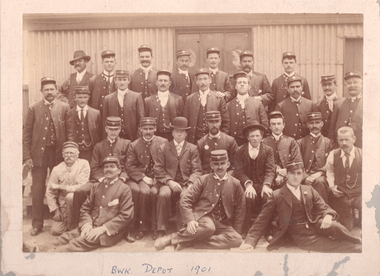 Melbourne Tram Museum
Photograph - Cable tram crews Brunswick Depot, August 1901
Photograph of cable tram crews and staff at Brunswick Depot, dated 1901 - shows 23 men in cable tram traffic uniform and five men in office or workshop clothing.Yields information about the Brunswick cable tram depot staff and crews in 1901.Black and white photograph mounted on embossed partly stippled card. Second image, converted to gray scale and straightened.On underside of photo "BWK Depot 1901" in ink and on rear "Sunday August 1901" and "Brunswick Depot" in ink.cable trams, crews, brunswick depot, officers, workshops -
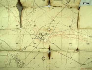 Bendigo Military Museum
Map - TRENCH MAP, FRANCE WW1, 1917
Areas covered on this map are, “Bullecourt, Reincourt, Hendecourt”. Item relates to William Alexander No 502 AIF. Refer Cat No 3746.3 for his service details.Trench map, France, scale 1:10,000, German trenches in red, trenches corrected to 6.4.1917, Edition 2.map, france, trench -
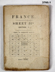 Bendigo Military Museum
Map - MAPS, FRANCE WW1, 1915 - 1917
(.1) Areas covered by this map, Somain to Valenciennes, Ramillies to Beaudignies. (.2) Areas covered on this map, Bellicourt to Tupigny, St Quentin to Guise. (.3) Areas covered on this map, Heslin to lens, Domart to Baupaume. (.4) Areas covered on this map, Dieppe to Le Quesnoy, Monville to Bonniers. (.5) Same as (.2) Items relate to William Alexander No 502 AIF. Refer 3746.3 for his service details.(.1) Map, France, sheet 51A, Edition 1, scale 1:40,000, Ordnance survey 1916, gauze lined, rear has glossary of terms French to English. (.2) Map, France, sheet 62B, first edition, scale 1:40,000, Ordnance survey December 1917, gauze lined, rear has glossary of terms French to English. (.3) Map France, Lens 11, scale 1:100,000, OSO 1915, gauze lined. (.4) map, France, Dieppe 16, scale 1:100,000, general staff No 2364, War Office 19– gauze lined. (.5) Map, France (same as (.2)(.2 & .5) On rear hand written “124 A.L.T.M.B P179/5maps, france -
 Federation University Historical Collection
Map - Geological, Tallangatta, New South Wales: 1:250,000 Geological Series, SJ 55-3, 1966, 1966
Compiled by the Geological Survey of N.S.W., Division of Regional Geology. Topographical base compiled from Snowy Mountains Hydro Electrical Authority, Department of Lands, County maps and Snowy Lease Map. Other sheet adjoin this map. There are 13 formation sections grouped into 9 - Quaternary, Tertiary, Middle Devonian, Lower to Middle Devonian, Lower Devonian, Upper Silurian, Silurian, Upper Ordovician and Ordovician.Large coloured map showing geological features, faults, bores, rivers and mineral deposits.Scale of map, longitude and latitude, river names. "Tallangatta 1:250,00" written in black pen.tallangatta, new south wales, geological survey, topographical base, snowy mountains hydro electrical authority, department of lands, snowy lease map, department of mines, quaternary, tertiary, middle devonian, lower to middle devonian, lower devonian, uper siluran, silurian, upper ordovician, ordovician -
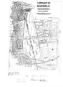 Halls Gap & Grampians Historical Society
Map - Photocopy
Photocopy of map of Heatherlie TownshipTownship of Heatherlie; Parish of Boroka; County of Borung; scale measurement; R.O. Robson Authorised Surveyormaps, heatherlie township -
 Halls Gap & Grampians Historical Society
Map - Coloured
Map showing layout for township of HeatherlieTownship of Heatherlie; Parish of Boroka; County of Borung; scale measurement; R.O. Robson Authorised surveyormaps, heatherlie township -
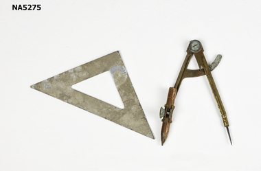 Whitehorse Historical Society Inc.
Instrument - Compass & Set Square, C 1950's
Example of school equipment, c 1950'sExample of equipment used in the teaching of geometry.Example of school geometry equipment.C E H engraved on reverse of set square. Mathematic scales on face of set square.school equipment, geometry -
 Ballarat Tramway Museum
Document - Photocopy, City of Ballaarat, Plan of Gardens, 1920s?
Photocopy - No Number, no date, other than BTM Number 228, No title – plan showing roads and trees in the Gardens area, early drawings, many roads on the east side of Lake Wendouree not built . Photocopy onto heat sensitive paper – 9 separate sheets joined with tape. An additional sheet added at the St. Aidans end showing roads – in pencil. Probably compiled for the BTPS by Bill Kingsley for planning purposes.Has “228” in biro on rear of sheet, and “Scale 100 foot to 1 inch” on front of sheet.trams, tramways, signals, forest city signals, equipment, electrical engineering -
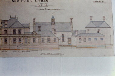 Kew Historical Society Inc
Slide - Architectural Drawing, Kew Public Offices, 1887
A civic campaign for new public offices developed in Kew in the 1880s. After much deliberation, the location chosen was the junction of Bulleen and Cotham Roads. The buildings were designed by George Watson and John Henry Harvey, architects within the Department of Public Works (Victoria). Building was commenced in 1887, and after one year, the buildings were opened. The Post Office was transferred to the new Commonwealth Government in 1901. The Police Station and Court House, sold by the Victorian Government to the City of Boroondara in 2007, are now a community cultural centre and performing arts venue.The buildings were listed on the Victorian Heritage Register Register (HO885) in 1991. They are historically and architecturally significant to the State Of Victoria because Watson and Harvey's designs exhibit diversity in integrating civil offices, they accommodate the apex of road junctions, and they demonstrate a departure from the contemporaneously favoured High Victorian Classical to the Queen Anne style in the design of civic buildings. 35mm colour transparency of an original plan by George Watson and John Henry Harvey, architects of the Department of Public Works (Victoria), in 1887 for New Public Offices at Kew. This plan was copied by the donor from an original held at the Commonwealth Archives in Brighton (Vic). The copy was made to illustrate a report that the donor made on ‘The functional planning design, building materials and construction methods of the Kew Post Office’ as part of course work at RMIT.NEW PUBLIC OFFICES KEW / SCALE 8 FEET TO ONE INCH / COTHAM ROAD ELEVATIONkew court house, kew police station, kew post office, architectural drawings, khs - slides, new public offices -- kew (vic.), architecture — queen anne style -
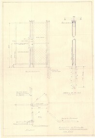 Falls Creek Historical Society
Plan - Diagram of Turnstile for New Chairlift
Bob (Herman) Hymans (a former member of the Royal Netherlands Navy was born in Bloemendaal, Holland on 30th September 1922. During World War II he fought against the Japanese in the Dutch East Indies (now Indonesia) and was imprisoned in Changi and on the Burma Railway. After gaining qualifications as a Ski Instructor, Bob arrived in Falls Creek in May 1950. Working as an Instructor and Supervisor at Bogong Lodge, Bob decided his future was in accommodation. He was successful in negotiating an indenture for land from the State Electricity Commission (SEC). It took Bob two years to build his Grande Coeur Chalet but, tragically, it was burned down in August 1961. Bob also built the first Chairlift in Australia. This was a single chairlift and the structure was built from wooden electricity poles. He was constantly full of new ideas and proposals for the village. Bob Hymans died on 7th May 2007. This Collection of documents and letters tells the story of Bob’s endeavours to develop Falls Creek into the ski village it is today. This map is significant because it documents plans made by Bob Hymans for Falls CreekThis diagram is part of Bob Hymans documents. It is a detailed plan, including elevation, detail of pivot and the general arrangement views of a turnstile. This is part of overall plans for the construction of a new chairlift at Falls Creek. At bottom of diagrams: PLAN TURNSTILE/ GENERAL ARRANGEMENT Scale 1 1/2" = 1'- 0"map of falls creek, falls creek leases, falls creek 1980s -
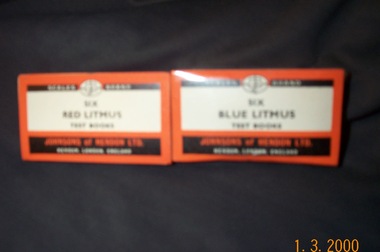 Clunes Museum
Functional object - LITMUS PAPER TEST BOOKS, JOHNSONS OF HENDON LTD
THESE ITEMS WERE USED IN THE CLUNES HOSPITAL, VICTORIA, AUSTRALIA.1 PKT 16 RED LITMUS TEST BOOKS .2 PKT 6 BLUE LITMUS TEST BOOKSSCALES BRAND, JOHNSON TEST BOOKS. THERE IS A COMPREHENSIVE RANGE OF JOHNSON TEST BOOKS, WRITE FOR LISTlocal history, medical pharmacy, medical -
The Ed Muirhead Physics Museum
Length Standards, NPL Certified, Archives
Certificate of Examination for #64 of one 6 inch glass scale, one 6 inch steel scale, and one 6 inch end gauge for Professor Lyle. 3 page document (copy) from National Physical Laboratory, Teddington. Paper held together with pin. (See also #63) -
Tatura Irrigation & Wartime Camps Museum
Water Wheel Accuracy Tester, Late 1900s
Used by State Rivers and Water Supply Commission prior to their privatisation about 1990.A clear tube with sand inside - similar to an egg timer. Used to measure the accuracy of water wheels over a half minute or less. Measurements marked on outside and related to one revolution. The blue scales relate to small meter outlets(wheels), yellow scales related to large meter outlets(wheels).Figures of rates relating to measurement of water in one revolution.irrigation, victoria state rivers and water supply commission, water wheel -
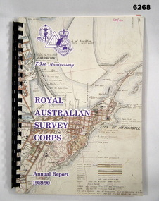 Bendigo Military Museum
Administrative record - 75th Anniversary of the Royal Australian Survey Corps - Annual Report 1989/90, Royal Australian Survey Corps, 1990
Royal Australian Survey Corps Annual Report 1989/90 of all mapping and charting carried out during that periodAn A4 booklet, glossy pages, map index of all mapping scales, 17 pages and Annexes, plastic ring bindingroyal australian survey corps, rasvy, fortuna, army survey regiment, army svy regt, asr -
 Greensborough Historical Society
Maps, Mont Park, Gresswell, Larundel, 01/08/1949
Map of Mont Park area, including Larundel, Gresswell and Kingsbury Farm, between Plenty Road and Waiora Road, as at 1949, including buildings. Map of Mont Park area, including Larundel, Gresswell and Kingsbury Farm. Ink & pencil. Scale: 200': 1 inch49/147, R. G. H.mont park, larundel, gresswell watsonia, kingsbury -
Glenelg Shire Council Cultural Collection
Sculpture - Model - Portland Harbour, n.d
PORT OF PORTLAND COLLECTIONScale model of Portland Harbour in display case. Case: four sided, pyramidal, on collapsible legs. Portland Harbour Developmentportland harbour, scale model, structure, harbour development -
 Glenelg Shire Council Cultural Collection
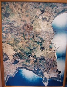
Photograph - Photograph - aerial view of Portland, 1988
Census Project No. 1995. Portland Dec. 1988.Aerial view of the "City of Portland" and surrounding rural area to a scale of 1:10,000 Aerial Photomosaic of Portland Bay, 1988Front: (no inscriptions) Back: (no inscriptions)aerial photography, central portland, portland harbour -
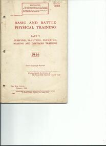 4th/19th Prince of Wales's Light Horse Regiment Unit History Room
Booklet, Basic and Battle Physical Training Part V, 1946, Feb 1946
Soft covered booklet covering jumping, vaulting, climbing, scaling and obstacle training. With line drawings of various training skillsWO Code No 7048army physical training -
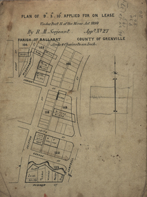 Federation University Historical Collection
Plan, Lease Applied for by R.M. Serjeant, c1890, c1890
Plan of a lease showing streets around Skipton and Windermere Streets, Redan. Scale 4 chains to 1 inch (!:3168)serjeant, r.m.serjeant, robert m. serjeant, george street, skiptn street, windermere stret, rubicon stret, cobdon street, ascot street, lease, redan, ballarat, robert malachi serjeant, band of hope and albion mine -
Port Melbourne Historical & Preservation Society
Map - Melbourne and suburbs, MMBW, 8 Dec 1909
MMBW map of Melbourne and suburbs - Record plan up to July 1st 1913 (scale 3/4" = 1 mile)engineering - board of works, calder e oliver, russwaul(?)