Showing 3153 items matching "south west"
-
 Whitehorse Historical Society Inc.
Article, Shopping centre facelift, 1983
... A new building for the south-west corner of Whitehorse Road.... A new building for the south-west corner of Whitehorse Road ...A new building for the south-west corner of Whitehorse Road and Station Street Mitcham.A new building for the south-west corner of Whitehorse Road and Station Street Mitcham. The upper floor offices are to be occupied by the legal firm, Mulcahy, Mendelson and Round. The site was originally that of the Hill Hotel.A new building for the south-west corner of Whitehorse Road and Station Street Mitcham. mitcham shopping centre, whitehorse road, mitcham, station street, mitcham, mendelson, roger, mulcahy, mendelson and round, hill hotel, mitcham -
 Whitehorse Historical Society Inc.
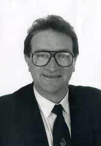
Photograph, Peter Allan - Councillor
... , Councillor, West Ward, August 1986 to August 1989 and South West Ward..., August 1986 to August 1989 and South West Ward August 1990 ...Black & white photograph of Peter John, Anthony Allan , Councillor, West Ward, August 1986 to August 1989 and South West Ward August 1990 to December 1994, City of Nunawading.allan, peter, city of nunawading -
 8th/13th Victorian Mounted Rifles Regimental Collection
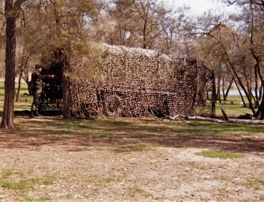
Photograph
... with camouflage net,during " B " vehicle exercise in south west Victoria... " vehicle exercise in south west Victoria conducted by 8/13 ...Exercise of this type aimed to practice driver skills, map reading, camouflage and concealment. The 8th/13th Victorian Mounted Rifles was raised as a regiment of the Royal Australian Armoured Corps on 1 May 1948 with Headquarters in Melbourne and squadrons in Sale, Benalla/Wangaratta and Albury. In 1955 Regimental Headquarters moved to Wangaratta and a second squadron was located at Albury. The Sale squadron transferred to 4th/19th Prince of Wales’s Light Horse. In 1977 8/13 VMR Regiment was reduced to an independent squadron A Squadron 8th/13th Victorian Mounted Rifles and in 1991 was linked with 4th/19th Prince of Wales’s Light Horse forming the VMR Squadron of that regiment.Colour photograph of truck in scrub-land covered with camouflage net,during " B " vehicle exercise in south west Victoria conducted by 8/13 Victorian Mounted Rifles, c. 1986. -
 Queen Victoria Women's Centre
Photograph, 5 February 1996
... south west. in 2015 is the QV square towards the QVWC office... of building facing south west. in 2015 is the QV square towards ...Colour photograph. North exterior wall of building facing south west. in 2015 is the QV square towards the QVWC office and the QVWC building's north entrance. Taken during restoration inspection. building construction, historic buildings, cultural structures and establishments -
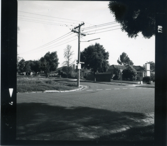
 Ringwood and District Historical Society
Photograph, Intersection of Warrandyte Road with Old Warrandyte Road and Tortice Dr. 1981
... Written on back of photograph, "19/6/81. Looking south..., "19/6/81. Looking south-west from intersection of Warrandyte ...Written on back of photograph, "19/6/81. Looking south-west from intersection of Warrandyte Road with Old Warrandyte Road and Tortice Dr." -
Lara RSL Sub Branch
Silk Maps, Four Collective maps
... fabric....Hong Kong /Canton.Map 3Cloth Map East Java South West... Kong /Canton.Map 3Cloth Map East Java South West Pacific.Map 4 ...Scientific or research signifigance.Map 1....Silk Fabric ... "Western Pacific.Map 2....Silk fabric....Hong Kong /Canton.Map 3Cloth Map East Java South West Pacific.Map 4....Arakan/Irrawaddy fabric map.MMap 4....Restricted..Edition 1 -gsgsFabric Map 1;1,000,000 Map 3....No 25 Timor/No 26 East Java .Map 2 Hong Kong/Canton restricted MAP 1,NACI - HO. No.S 12. -
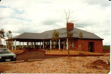 Hume City Civic Collection
Photograph, 1/10/1978
... A coloured photograph of the clubhouse taken from the south... photograph of the clubhouse taken from the south west ...On 4th August 1978 the construction of the Goonawarra Housing Estate commenced. The estate was formerly known as the Goonawarra Farm and overloked the Sunbury town area and Jacksons Creek valley. Plans for the new development included a gold course, housing, community and recreational facilities. The construction continued througout the last two decades of the twentieth century and into the twenty first century.A coloured photograph of the clubhouse taken from the south west at the Goonawarra Golf Club. The surrounding garden has been planted out with trees and has been mulched. A green car is on the LHS of the photograph.goonawarra farm, goonawarra golf club, goonawarra housing estate, sharkey, robert b., kilkenny homes, australian ideas homes pty.ltd., craftsmen homes., glamor homes, villa bella homes, george evans collection -
 Flagstaff Hill Maritime Museum and Village
Mast Collar, c. 1886
... on a reef close to the shore west of Peterborough, South West... OF HALLADALE, wrecked off the coast of Peterborough, South West... of Peterborough, South West Victoria, on November 14th. All 29 crew ...The husband of the donor of this mast collar chanced to be staying a night at a motel in Peterborough, along the Great Ocean Road in Victoria. He had a keen interest in maritime items and recognise the mast collar at the motel’s back fence line. The motel owner told his guest the story of a customer, a doctor, who had organised and paid for divers to raise the mast collar from a local shipwreck, the Falls of Halladale. Shortly afterwards the doctor passed away, so the mast collar had remained at the motel site. The owner was leaving the motel the following week and wasn’t at all interested in the artefact. He was very happy for his guest to remove it. It took five men to load the mast collar up for the trip to the new owner’s two storey shed in Ballarat. It stayed there undercover, in the company of his collection of 5 buggies, for the next 40 or so years until the property was for sale. A friend, who realised the significance of the mast collar, suggested that it be donated to Flagstaff Hill Maritime Village where other artefacts from the Falls of Halladale, such as the slate tiles, were on display. This mast collar, or masthead, from the Falls of Halladale would have been used to join two sections of one of the tall masts. As sailing ships became larger there was a need for taller masts or spars, which became difficult or impossible to find. To overcome this problem mast was divided into sections; lower and top or upper mast (on some of the ‘tall ships’ a mast could be divided into three or even four sections). The Falls of Halladale was a four-masted British barque built-in 1886. On what turned out to be her fatal journey, she had left New York for Melbourne in late 1908. She ran aground on a reef close to the shore west of Peterborough, South West Victoria, on November 14th. All 29 crew eventually landed safely onshore. The wrecked ship stayed on the reef for several months as locals watched the sails slowly deteriorate. The salvaged cargo included slate tiles, as mentioned above, and many of these have been used on the roof of buildings at the Flagstaff Hill Maritime Village. The iron-hulled, four-masted barque, the Falls of Halladale, was a bulk carrier of general cargo. She left New York in August 1908 on her way to Melbourne and Sydney. In her hold, along with 56,763 tiles of unusual beautiful green American slates (roofing tiles), 5,673 coils of barbed wire, 600 stoves, 500 sewing machines, 6500 gallons of oil, 14400 gallons of benzene, and many other manufactured items, were 117 cases of crockery and glassware. Three months later and close to her destination, a navigational error caused the Falls of Halladale to be wrecked on a reef off the Peterborough headland at 3 am on the morning of the 15th of November, 1908. The captain and 29 crew members all survived, but her valuable cargo was largely lost, despite two salvage attempts in 1908-09 and 1910. ABOUT THE ‘FALLS OF HALLADALE’ (1886 - 1908) Built: in1886 by Russell & Co., Greenock shipyards, River Clyde, Scotland, UK. The company was founded in 1870 (or 1873) as a partnership between Joseph Russell (1834-1917), Anderson Rodger and William Todd Lithgow. During the period 1882-92 Russell & Co., standardised designs, which sped up their building process so much that they were able to build 271 ships over that time. In 1886 they introduced a 3000 ton class of sailing vessel with auxiliary engines and brace halyard winches. In 1890 they broke the world output record. Owner: Falls Line, Wright, Breakenridge & Co, 111 Union Street, Glasgow, Scotland. Configuration: Four masted sailing ship; iron-hulled barque; iron masts, wire rigging, fore & aft lifting bridges. Size: Length 83.87m x Breadth 12.6m x Depth 7.23m, Gross tonnage 2085 ton Wrecked: the night of 14th November 1908, Curdies Inlet, Peterborough south west Victoria Crew: 29 The Falls of Halladale was a four-masted sailing ship built-in 1886 in Glasgow, Scotland, for the long-distance cargo trade and was mostly used for Pacific grain trade. She was owned by Wright, Breakenridge & Co of Glasgow and was one of several Falls Line ships, all of which were named after waterfalls in Scotland. The lines flag was of red, blue and white vertical stripes. The Falls of Halladale had a sturdy construction built to carry maximum cargo and able to maintain full sail in heavy gales, one of the last of the ‘windjammers’ that sailed the Trade Route. She and her sister ship, the Falls of Garry, were the first ships in the world to include fore and aft lifting bridges. Previous to this, heavily loaded vessels could have heavy seas break along the full length of the deck, causing serious injury or even death to those on deck. The new, raised catwalk-type decking allowed the crew to move above the deck stormy conditions. This idea is still used today on the most modern tankers and cargo vessels and has proved to be an important step forward in the safety of men at sea. On 4th August 1908, with new sails, 29 crew, and 2800 tons of cargo, the Falls of Halladale left New York, bound for Melbourne and Sydney via the Cape of Good Hope. The cargo on board was valued at £35,000 and included 56,763 tiles of American slate roofing tiles (roof slates), 5,673 coils of barbed wire, 600 stoves, 500 sewing machines, 6,500 gallons of oil, 14,400 gallons of benzene, plumbing iron, 117 cases of crockery and glassware and many other manufactured items. The Falls of Halladale had been at sail for 102 days when, at 3 am on the night of 14th November 1908, under full sail in calm seas with a six knots breeze behind and misleading fog along the coast, the great vessel rose upon an ocean swell and settled on top of a submerged reef near Peterborough on the south-west Victoria’s coast. The ship was jammed on the rocks and began filling with water. The crew launched the two lifeboats and all 29 crew landed safely on the beach over 4 miles away at the Bay of Islands. The postmistress at Peterborough, who kept a watch for vessels in distress, saw the stranding and sent out an alert to the local people. A rescue party went to the aid of the sailors and the Port Campbell rocket crew was dispatched, but the crew had all managed to reach shore safely by the time help arrived. The ship stayed in full sail on the rocky shelf for nearly two months, attracting hundreds of sightseers who watched her slowly disintegrate until the pounding seas and dynamiting by salvagers finally broke her back, and her remains disappeared back into deeper water. The valuable cargo was largely lost, despite two salvage attempts in 1908-09 and 1910. Further salvage operations were made from 1974-1986, during which time 22,000 slate tiles were recovered with the help of 14 oil drums to float them, plus personal artefacts, ship fittings, reams of paper and other items. The Court of Marine Inquiry in Melbourne ruled that the foundering of the ship was entirely due to Captain David Wood Thomson’s navigational error, not too technical failure of the Clyde-built ship. The shipwreck is a popular site for divers, about 300m offshore and in 3 – 15m of water. Some of the original cargo can be seen at the site, including pieces of roof slate and coils of barbed wire. This mast collar is significant due to its association with the ship FALLS OF HALLADALE, which is listed on the Victorian Heritage Register, VHR S255 The Falls of Halladale shipwreck is listed on the Victorian Heritage Register (No. S255). She was one of the last ships to sail the Trade Routes. She is one of the first vessels to have fore and aft lifting bridges. She is an example of the remains of an International Cargo Ship and also represents aspects of Victoria’s shipping industry. The wreck is protected as a Historic Shipwreck under the Commonwealth Historic Shipwrecks Act (1976). Mast collar, steel, salvaged from the shipwreck FALLS OF HALLADALE, wrecked off the coast of Peterborough, South West Victoria. Oval shaped a band of metal with a straight band of same heights attached between the long sides. Two metal loops are attached to the outside of the oval shape, next to the crossing band. flagstaff hill, warrnambool, shipwrecked coast, flagstaff hill maritime museum, maritime museum, shipwreck coast, flagstaff hill maritime village, great ocean road, falls of halladale, shipwreck peterborough vic, sailing ship mast collar, masthead of sailing ship, falls of halladale mast collar, masthead, mast collar, ship rigging 1908, russell & co. -
Glenelg Shire Council Cultural Collection
Postcard - Postcard - Princess Margaret Rose Cave, n.d
... , SOUTH WEST VICTORIA, AUSTRALIA'.... border, with black print 'PRINCESS MARGARET ROSE CAVE, SOUTH WEST ...Full colour photo/postcard of the interior of one of the Princess Margaret Rose Caves, showing stalagmites and stalactites; white border, with black print 'PRINCESS MARGARET ROSE CAVE, SOUTH WEST VICTORIA, AUSTRALIA'.postcard, tourism -
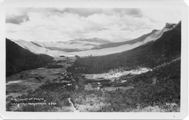 Halls Gap & Grampians Historical Society
Postcard - B/W
... is running south-west..... Buildings are also visible in middle area. View is running south ...Photo on card was taken by Gilbert Rogers, a photographer and tour guide during the 1930s. This postcard is one of a series.Depicts as valley with mountains on both sides. Cleared land can be seen on either side of a road which runs through the valley. Buildings are also visible in middle area. View is running south-west.scenery, fyans valley -
Glen Eira Historical Society
Document - Historic Conservation Areas Project
... ’ North Ward East Ward South Ward West Ward Kooyong Road Neerim ...Contains 4 items relating to historic conservation: 1/Five newsletters (one page each newsletter, dated 07/1975, 08/1975, 09/1975, 10/1975 and the final one 12/1975) describing how the project evolved, project funds, progress, study method, project 1 report, project 2 report and summary as no further funds available. Project was to include all of Melbourne but funding did not allow this. Note: newsletters stamped with Caulfield Historical Society. 2/Letter (one page on official city of Caulfield letterhead) from Andrew Rodda (manager planning) to Hazal Ford (dated 13/11/1989) describing ‘council resolved on 18/07/1989 to proceed with preliminary conservation survey’ and mentions that a copy is included. 3/Preliminary conservation survey for the City of Caulfield (nine pages) describing background, study area, budget, purpose, study outline, timeframe, report format, ownership, tasks and background information (mentions number and types of houses and properties as at 1986 and 1988) and a map of City of Caulfield. 4/Booklet (28 pages) titled ‘Heritage Area – Caulfield North Draft Heritage Guidelines July 1999 – City of Glen Eira’, containing Caulfield North Heritage Area, cultural heritage, Heritage Overlay Area, architectural description, common architectural forms and features, development guidelines, key design checklist. It includes a map of the Caulfield North Heritage Overlay Area, two illustrations about the development envelope and many black-and-white photographs of houses and architectural features.historic conservation areas project niven barbara, newsletters, town planning, historic buildings, heritage studies, housing, royal historical society of victoria (rhsv), read michael, plans, local government, historical societies, committee for urban action (cua), national trust, hopkins sherry ms., ford hazel, preliminary conservation survey, town planning, heritage studies, rodda andrew, city of caulfield, housing estates, victoria national estate grants program, australia icomos, burra charter, buildings structures and establishments, land surveys, suburbs, historic buildings, architectural significance, ‘caulfield’s heritage study’, soloman geulah dr., caulfield library, dandenong road, nepean highway, hotham street, iknerman road, orrong road, north road, poath road, ‘plan of the city of caulfield’, north ward, east ward, south ward, west ward, kooyong road, neerim road, bambra road, balaclava road, shire of caulfield, railways, world war 1914-1918, depression 1929-1939, rippon lea, labassa, parks, mansions, community services, ‘caulfield north draft heritage guidelines july 1999’, city of glen eira, caulfield north heritage area, glen eira heritage management plan, mayfield grove, normanby avenue, carnarvon street, glenferrie street, arthur street, malakoff street, normanby road, heritage advisory service, construction materials, victorian style, mediterranean style, spanish mission style, californian bungalow style, federation style, architectural style, architectural features, heritage conservation design, building construction, building regulations, aboriginal peoples, carnarvon road -
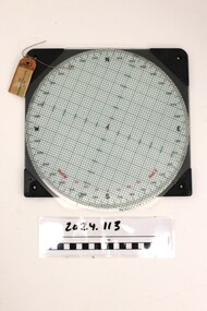 National Vietnam Veterans Museum (NVVM)
Instrument - Plotting Board, M19
... North, South, East , West / Rotating disc calibrated..., South, East , West / Rotating disc calibrated with numbers ...Standard issue item as used by Australian servicemen during conflict in Vietnam (1962-1973). Plotting boards are a secondary means of firing control for all mortars. The user can determine deflection, azimuth, and range.The M19 plotting board consists of a rotating disk of transparent plastic and a removable range arm (missing), both attached to a flat round white grid base.North, South, East , West / Rotating disc calibrated with numbersplotting board, m19, mortar -
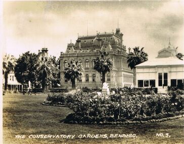 Bendigo Historical Society Inc.
Photograph - LESLIE JOHN BAGUST COLLECTION: THE CONSERVATORY GARDENS, 1940
... . View south west through the gardens towards Bull Street.... View south west through the gardens towards Bull Street ...Leslie John Bagust Collection. Black & White Photo The Conservatory Gardens Bendigo 1940 Tourism Postcard Collection Series. View south west through the gardens towards Bull Street and the Bendigo Law Courts.bendigo, tourism, the conservatory gardens bendigo, http://www.bendigo.ws/bendigo-attractions/bendigo-gardens/conservatory-gardens.html -
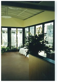 Queen Victoria Women's Centre
Photograph, c.1997
... renovations works have been competed. Taken facing south west... south west. There is a room divider in the foreground, left ...Colour photograph. Interior of level 5 atrium after renovations works have been competed. Taken facing south west. There is a room divider in the foreground, left of frame. Stained glass window seen in background. historic buildings, cultural structures and establishments, christmas, official events -
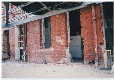 Queen Victoria Women's Centre
Photograph, August 1996
... Colour photograph. Ground floor acing south west into QVWC... south west into QVWC tower in what was to be the cafe. Entrances ...Colour photograph. Ground floor acing south west into QVWC tower in what was to be the cafe. Entrances show access corridors to ormer towers. New structure for roof seen with black tarp. Taken during restoration inspectionbuilding construction, historic buildings, cultural structures and establishments -
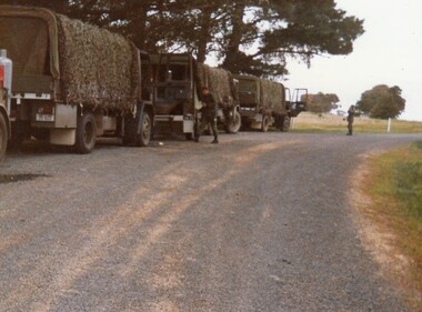 8th/13th Victorian Mounted Rifles Regimental Collection
Photograph
... Victorian Mounted Rifles ' B ' vehicle exercise in south-west... Victorian Mounted Rifles ' B ' vehicle exercise in south-west ...Unarmoured vehicles were classified as ' B ' vehicles. Armoured vehicles were claswsified as " A " vehicles. The 8th/13th Victorian Mounted Rifles was raised as a regiment of the Royal Australian Armoured Corps on 1 May 1948 with Headquarters in Melbourne and squadrons in Sale, Benalla/Wangaratta and Albury. In 1955 Regimental Headquarters moved to Wangaratta and a second squadron was located at Albury. The Sale squadron transferred to 4th/19th Prince of Wales’s Light Horse. In 1977 8/13 VMR Regiment was reduced to an independent squadron A Squadron 8th/13th Victorian Mounted Rifles and in 1991 was linked with 4th/19th Prince of Wales’s Light Horse forming the VMR Squadron of that regiment.Colour photograph of trucks halted on roadside during 8/13 Victorian Mounted Rifles ' B ' vehicle exercise in south-west Victoria, c. 1986. Skills practiced were driving and maintenance, radio communications and map reading. -
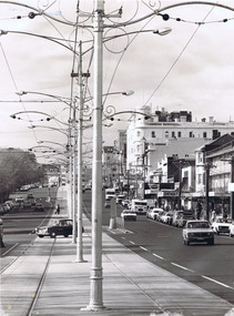
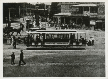 Ballarat Tramway Museum
Photograph - Black & White Photograph/s, The Bendigonian, Jan. 2005
... and the south west corner buildings in the photograph. Features a three... on the south west corner of Charing Cross, featuring an advertisement ...Black and White copy print contained within the Wal Jack Bendigo and Geelong Album, see Reg Item 5003 for more details. Photo of Charring cross looking from Pall Mall towards High St and the south west corner buildings in the photograph. Features a three window ESCo. tramcar In the background are the buildings on the south west corner of Charing Cross, featuring an advertisement for The Age, Cooperative Distribution centre, Warrens View Point Hotel, Hamptons Newsagency and Connelly & Co. Copied by Keith Kings from The Bendigonian 3/1/1905. On rear in ink " SA776 Bendigo A 3 window saloon at Charring Cross" Copied ex "The Bendigonian 3/1/1905."trams, tramways, bendigo, charing cross, esco -
Whitehorse Historical Society Inc.
Article, Smear campaign on Cr Cooper fails, 1991
... Cr Cooper of South West Ward, City of Nunawading... McPhee Peter Spurr Noel Rose Joseph Cr Cooper of South West Ward ...Cr Cooper of South West Ward, City of Nunawading, was victorious at the municipal election after an attempt to sabotage his campaign by circulating sensationalized pamphlets urging residents not to vote for him.Cr Cooper of South West Ward, City of Nunawading, was victorious at the municipal election after an attempt to sabotage his campaign by circulating sensationalized pamphlets urging residents not to vote for him. Full details of election given with some comments by candidates.Cr Cooper of South West Ward, City of Nunawading, was victorious at the municipal election after an attempt to sabotage his campaign by circulating sensationalized pamphlets urging residents not to vote for him. local government, city of nunawading, cooper, les, morgan, joan, rawlings, andrew, van der hyde, sid, plummer, jan, mcphee, peter, spurr, noel, rose, joseph -
 Whitehorse Historical Society Inc.
Photograph, Doncaster East Road, Mitcham, No.35, 2006
... Coloured photo of south - west side of the Winchcombe... road mitcham no.35 Coloured photo of south - west side ...Coloured photo of south - west side of the Winchcombe family home on the corner of Doncaster East and Glen Roads, Mitcham in 2006 Mrs. Winchcombe, nee Ireland is related to the Ireland family who were orchardists and florist in Mitcham area in the early 1900s.winchcombe family, ireland family, doncaster east road, mitcham, no.35 -
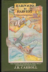 Port Fairy Historical Society Museum and Archives
Book, Warrnambool Institute Press, Harpoons to harvest : the story of Charles and John Mills, pioneers of Port Fairy / J.R. Carroll, 1989
... settlers in the South West ... the stories of the early settlers in the South West The story ...The story of Charles and John Mills, pioneers of Port Fairy. Includes genealogical information.xv, 286 p., [12] p. of plates : ill., geneal. tables, maps, ports. Includes index. Geneal. tables on lining papers. Bibliography: p. 225-260non-fictionThe story of Charles and John Mills, pioneers of Port Fairy. Includes genealogical information. maritime, mills, john brabyn, 1810-1877, charles frederick, 1812-1855, mills family, pioneers -- victoria -- port fairy -- biography, pioneers -- tasmania -- biography, australian history, biography, exploration, genealogy, harbour master, mills : charles and john, mills brothers, port fairy, shipping, warrnambool history, whaling, wrecks, book -
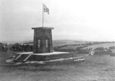 Surrey Hills Historical Society Collection
photograph, Ken Hall, Beckett Park Soldiers War Memorial c1932, c1980
... with the memorial in the foreground and looking to the south-west... with the memorial in the foreground and looking to the south-west ...Copy negative by Ken Hall from a c1933 City of Camberwell brochure. The original appears to have had a crease mark across it as this is evident on both copies.Black and white photo of the First World War memorial erected on the high point in Beckett Park, Balwyn. Taken with the memorial in the foreground and looking to the south-west. The Australian flag is flying on top of the monument and in the background are rows of trees dividing largely clear land.On the rear: Copy 1: "1153 Repeat of No 164" in top left hand corner in lead pencil in Jocelyn Hall's hand. Copy 2: "1153 Repeat of No 164" in top left hand corner in lead pencil in Jocelyn Hall's hand and "Soldiers War Memorial / Beckett Park / Erected 1918" in blue biro centre right.first world war, war memorial, beckett park -
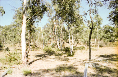 Eltham District Historical Society Inc
Photograph, Hohne's Hill, opposite Eltham Lower Park, c.Mar. 1983
... Hohnes Hill Reserve opposite Eltham Lower Park, south west... melbourne Hohnes Hill Reserve opposite Eltham Lower Park, south west ...Hohnes Hill Reserve opposite Eltham Lower Park, south west sideRoll of 35mm colour negative film, 4 stripsKodak Safety 5035eltham lower park, hohnes reserve -
 St Kilda Historical Society
Postcard - Photograph Streetscape, Fitzroy St, St Kilda
... view from south west end of Fitzroy St looking north east... Carlisle Street St Kilda melbourne view from south west end ...view from south west end of Fitzroy St looking north eastblack and white photograph -
 Whitehorse Historical Society Inc.
Photograph, Burwood Technical School
... Burwood Technical School was located on the south west... on the south west corner of Middleborough and Elgar Roads schools ...Burwood Technical School was located on the south west corner of Middleborough and Elgar RoadsStrip of four coloured aerial photo of the Burwood Technical School Buildings taken sometime between 1986 and 1992.schools, burwood technical school -
 Whitehorse Historical Society Inc.
Photograph, Corner Victoria & Edward Streets, Mitcham, c 1987
... and Edwards Streets, Mitcham; looking south and west c. 1987... and Edwards Streets, Mitcham; looking south and west c. 1987 Corner ...Photograph taken prior to the building of the Coles supermarket and car parkBlack and white photograph of the corner of Victoria and Edwards Streets, Mitcham; looking south and west c. 1987victoria street, mitcham, edward street -
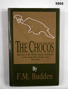 Bendigo Military Museum
Book - BOOK, MILITIA INFANTRY BATTALION, F. M. BULDEN, "The Chocos", 1987
... Battalions/ in the South West Pacific Area/ 1941-1945"... Battalions/ in the South West Pacific Area/ 1941-1945" Books ..."THE CHOCOS" - "The story of the Militia Infantry Battalions/ in the South West Pacific Area/ 1941-1945"Hard cover book with dust cover. Hard cover - cardboard, mid green buckram, gold print front and spine. Dust cover - paper, mid green and gold print on front, spine and back. Illustrated in white print, front one, back two map outlines of Islands. 314 pages, paper, cut, plain, white. Illustrated black and white photographs and maps.books, battalions, pacific war, 1941-1945, ww2 -
Glenelg Shire Council Cultural Collection
Photograph - Contact Print - S.S. Eumeralla, Portland, 1900s
... and passengers along the south west coast of Victoria.... was a steamship and transported cargo and passengers along the south west ...The SS Eumeralla was a steamship and transported cargo and passengers along the south west coast of Victoria.Black and white contact print from glass plate negative. Image shows rear deck of SS Eumeralla, with numerous passengers.ss eumeralla, steamship, cargo, cargo carrier -
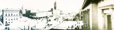 City of Ballarat Libraries
Photograph - Card Box Photographs, Panorama view of Sturt Street, Ballarat circa 1903
... Panoramic view of Sturt Street looking south west taken... south west taken from the GPO Building. Panorama Sturt Street ...Panoramic view of Sturt Street looking south west taken from the GPO Building.panorama, sturt street, streetscape, building, public, commerical -
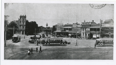 Ballarat Tramway Museum
Photograph - Black & White Photograph/s, The Bendigonian, Jan. 2005
... and the south west corner buildings in the photograph. Features three... and the south west corner buildings in the photograph. Features three ...Black and White copy print contained within the Wal Jack Bendigo and Geelong Album, see Reg Item 5003 for more details. Photo of Charring cross looking from Pall Mall towards High St and the south west corner buildings in the photograph. Features three ESCo trams, 2 x two window and 1 x 3 window at the location. In the background are the buildings on the south west corner of Charing Cross, featuring an advertisement for The Age, Cooperative Distribution centre, Warrens View Point Hotel, Hamptons Newsagency and Connelly & Co. Copied by Keith Kings from The Bendigonian 3/1/1905. On rear in ink " SA776 Tramcars at Charing Cross, Note" 3 window saloon" Copied ex "The Bendigonian 3/1/1905."trams, tramways, bendigo, charing cross, esco -
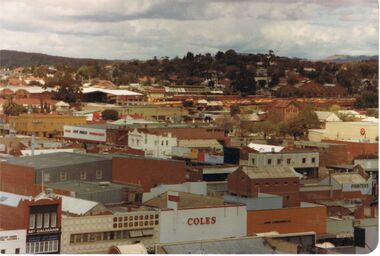 Bendigo Historical Society Inc.
Photograph - VIEW FROM OLD BENDIGO POST OFFICE CLOCK TOWER LOOKING SOUTHWEST TOWARDS QUARRY HILL
... View from old Bendigo Post Office Clock Tower South West... Tower South West in the direction of Quarry Hill. Names ...View from old Bendigo Post Office Clock Tower South West in the direction of Quarry Hill. Names that appear on buildings are Coles, McCalmans, Bolton printers, New World Supermarket, Hopetoun hotel Target, and above these show buildings on the Bendigo Railway Station site.bendigo, history, buildings/streetscapes, coles, mccalmans, printers (boltons), new world supermarket, target, hopetoun hotel, and railway yards and buildings.