Showing 601 items matching "victoria. department of planning "
-
 Federation University Historical Collection
Map - Geological Survey, J. Phillips, Geological Survey of Victoria - Ballarat, 1857, 10/1858
Geological map of the Ballarat District featuring four colours.ballarat, geological, geology, geological plan, main road, camp, golden point, pennyweight hill, clayton hill, ballaarat cemetery, bakery hill, specimen hill, soldiers hill, nightingale lead, native youth black hill flat, white flat, mining, mines, eureka lead, old post office hill -
 Wodonga & District Historical Society Inc
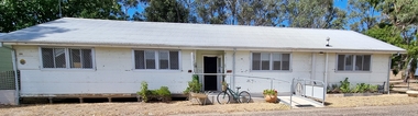
Photograph - Hut 97 Bonegilla Migrant Experience
Bonegilla Army Base and Migrant Reception Centre began when funds were allocated to build Bonegilla Army Camp in June 1940. Builders began to erect about 600 huts prior to the Army moving in during September of that year. Between 1942 - 1943 it was enlarged to 848 buildings. In 1947 Bonegilla Reception and Training Centre began operating with the Army providing transport, security and catering services. From 1949 until 1965 the Bonegilla Reception and Training Centre operated without a military presence. Bonegilla Migrant Reception and Training Centre was made up of 24 blocks. It had its own churches, banks, sporting fields, cinema, hospital, police station and railway platform. It became the largest and longest operating reception centre in the post-war era. More than 300,000 migrants passed through its doors between 1947 and 1971, with most of those originating from non-English speaking European countries. From1965 with the increased Australian commitment to the Vietnam War and the need to find accommodation to train National Servicemen for Vietnam, the Army negotiated with the Department of Immigration to take over several blocks at Bonegilla. In 1971 the Reception Centre closed and the site reverted to the Army. After 1971 the Army undertook a major site redevelopment with the construction of Latchford Barracks as the Army Apprentice School. Later Latchford Barracks was redeveloped into part of the Army Logistic Training Centre. Between 1978 and 1982, nearly all of the centre was demolished in a major redevelopment. The new replacement buildings were formally opened as Latchford Barracks in 1983. Demolition of the buildings prompted calls for recognition of the site and the role it had played in Australia’s post-World War II Immigration program. After much discussion between the Department of Army and Heritage and local groups about the significance of the site, the Australian Heritage Commission proceeded with its listing on the Register of the National Estate. A Conservation Management Plan was prepared for Block 19 in 1996. The Army transferred Block 19 to the Victorian Government. In 2002 Heritage Victoria listed Block 19 on the State Heritage Register, giving attention to both the migrant and army connections with the site. Hut 97 at Bonegilla Migrant Experience is the home of the Wodonga & District Historical Society Inc.This image is significant because it records a building which is part of the Bonegilla Migrant Reception Centre which played a critical role as the largest and longest operating Migrant Reception Centre in Australia.A colour photo of Hut 97 at Block 19, Bonegilla Migrant Experience, now the home of Wodonga & District Historical Society Inc.hut 97 bonegilla migrant experience, wodonga & district historical society, immigration australia -
 Falls Creek Historical Society
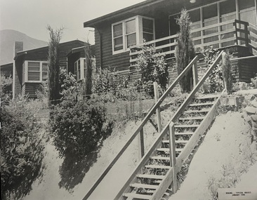
Photograph - Bogong Alpine Village Houses 1946
The images in the Bogong Village Collection were displayed in Bogong Jack’s Tavern for over 20 years and were donated to the Falls Creek Museum when the Tavern closed in 2021. In 1939, the State Electricity Commission of Victoria established a field headquarters at Bogong to house workers and their families for the Kiewa Hydroelectric Scheme which ran from the 1930s to the 1960s. The workmen's camp was originally started with tents and was called Junction Camp. By 1947, the village supported 300 workers and their families. It included 40 houses, a hostel for single staff, a post office, a police station, a medical centre, and a primary school. The staff hostel was known as Kiewa House. At the completion of the Scheme, in the 1960s, the village was opened to public/tourism use. In 1968 the Victorian Education Department acquired the camp buildings and four houses from the State Electricity Commission of Victoria to establish an Outdoor Education Centre which operated for over 50 years. The Kiewa Hydroelectric Scheme was privatized in the 1990s and sold to Southern Hydro, before being acquired by AGL in 2005. In 2023 the Grollo Group signed a 73 year sublease on Bogong Village and has plans for its redevelopment as a workers’ village.These images are significant because they capture the development of Bogong Village as an important element of the Kiewa Hydroelectric Scheme in Victoria.Two black and white images featuring houses in Bogong Village in January 1946. They are constructed of weatherboard, with brick chimneys and tin roofs. Timber steps lead up to the front door and a garden has been planted in front of the house.bogong alpine village, bogong high plains, bogong houses 1946 -
 Falls Creek Historical Society
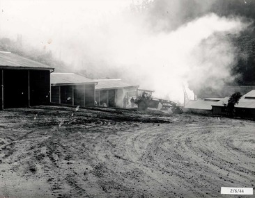
Photograph - Bogong Alpine Village 1944
The images in the Bogong Village Collection were displayed in Bogong Jack’s Tavern for over 20 years and were donated to the Falls Creek Museum when the Tavern closed in 2021. In 1939, the State Electricity Commission of Victoria established a field headquarters at Bogong to house workers and their families for the Kiewa Hydroelectric Scheme which ran from the 1930s to the 1960s. The workmen's camp was originally started with tents and was called Junction Camp. By 1947, the village supported 300 workers and their families. It included 40 houses, a hostel for single staff, a post office, a police station, a medical centre, and a primary school. The staff hostel was known as Kiewa House. At the completion of the Scheme, in the 1960s, the village was opened to public/tourism use. In 1968 the Victorian Education Department acquired the camp buildings and four houses from the State Electricity Commission of Victoria to establish an Outdoor Education Centre which operated for over 50 years. The Kiewa Hydroelectric Scheme was privatized in the 1990s and sold to Southern Hydro, before being acquired by AGL in 2005. In 2023 the Grollo Group signed a 73 year sublease on Bogong Village and has plans for its redevelopment as a workers’ village.These images are significant because they capture the development of Bogong Village as an important element of the Kiewa Hydroelectric Scheme in Victoria.A collection of four black and white images capturing the weather conditions in the Bogong area in June 1944bogong alpine village, bogong high plains, bogong june 1944 -
 Falls Creek Historical Society
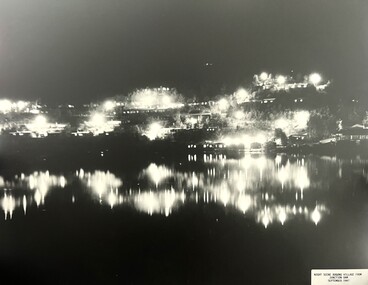
Photograph - Bogong Alpine Village 1947
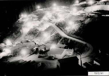
The images in the Bogong Village Collection were displayed in Bogong Jack’s Tavern for over 20 years and were donated to the Falls Creek Museum when the Tavern closed in 2021. In 1939, the State Electricity Commission of Victoria established a field headquarters at Bogong to house workers and their families for the Kiewa Hydroelectric Scheme which ran from the 1930s to the 1960s. The workmen's camp was originally started with tents and was called Junction Camp. By 1947, the village supported 300 workers and their families. It included 40 houses, a hostel for single staff, a post office, a police station, a medical centre, and a primary school. The staff hostel was known as Kiewa House. At the completion of the Scheme, in the 1960s, the village was opened to public/tourism use. In 1968 the Victorian Education Department acquired the camp buildings and four houses from the State Electricity Commission of Victoria to establish an Outdoor Education Centre which operated for over 50 years. The Kiewa Hydroelectric Scheme was privatized in the 1990s and sold to Southern Hydro, before being acquired by AGL in 2005. In 2023 the Grollo Group signed a 73 year sublease on Bogong Village and has plans for its redevelopment as a workers’ village.These images are significant because they capture the development of Bogong Village as an important element of the Kiewa Hydroelectric Scheme in Victoria.Two black and white images capturing Bogong Village by night and the spillway at Junction Dam.bogong alpine village, bogong high plains, bogong 1947 -
 Falls Creek Historical Society
Photograph - Jack Maddison Leading horses on the Bogong High Plain
The images in the Bogong Village Collection were displayed in Bogong Jack’s Tavern for over 20 years and were donated to the Falls Creek Museum when the Tavern closed in 2021. In 1939, the State Electricity Commission of Victoria established a field headquarters at Bogong to house workers and their families for the Kiewa Hydroelectric Scheme which ran from the 1930s to the 1960s. The workmen's camp was originally started with tents and was called Junction Camp. By 1947, the village supported 300 workers and their families. It included 40 houses, a hostel for single staff, a post office, a police station, a medical centre, and a primary school. The staff hostel was known as Kiewa House. At the completion of the Scheme, in the 1960s, the village was opened to public/tourism use. In 1968 the Victorian Education Department acquired the camp buildings and four houses from the State Electricity Commission of Victoria to establish an Outdoor Education Centre which operated for over 50 years. The Kiewa Hydroelectric Scheme was privatized in the 1990s and sold to Southern Hydro, before being acquired by AGL in 2005. In 2023 the Grollo Group signed a 73 year sublease on Bogong Village and has plans for its redevelopment as a workers’ village. John Maddison and his wife Mary Padman emigrated from London to Australia in 1850 with their five sons. Jack (John James William Maddison) was one of their great grandsons. In 1877 Jack’s grandfather George Maddison selected land between the East and West Kiewa branches of the Kiewa River - known as the "Island". It is now known as Mount Beauty. The Maddison family built Aertex Hut at the top of T Spur at Mt. Bogong for use when grazing cattle. It later became known as Maddison's Hut. Staircase Spur walking track at Bogong was formerly known as Maddison’s Track as it is the path once used by the Maddison family to drive their cattle on to the high plains. These images are significant because they feature the son of a pioneering family on the Bogong High Plains.A black and white photograph of Jack Maddison leading horses on the Bogong High Plains.bogong alpine village, bogong high plains, maddison family mt beauty, maddison's hut, aertex hut, -
 Falls Creek Historical Society
Photograph - Bogong Alpine Village and Howman's Dam Camp 1948
The images in the Bogong Village Collection were displayed in Bogong Jack’s Tavern for over 20 years and were donated to the Falls Creek Museum when the Tavern closed in 2021. In 1939, the State Electricity Commission of Victoria established a field headquarters at Bogong to house workers and their families for the Kiewa Hydroelectric Scheme which ran from the 1930s to the 1960s. The workmen's camp was originally started with tents and was called Junction Camp. By 1947, the village supported 300 workers and their families. It included 40 houses, a hostel for single staff, a post office, a police station, a medical centre, and a primary school. The staff hostel was known as Kiewa House. At the completion of the Scheme, in the 1960s, the village was opened to public/tourism use. In 1968 the Victorian Education Department acquired the camp buildings and four houses from the State Electricity Commission of Victoria to establish an Outdoor Education Centre which operated for over 50 years. The Kiewa Hydroelectric Scheme was privatized in the 1990s and sold to Southern Hydro, before being acquired by AGL in 2005. In 2023 the Grollo Group signed a 73 year sublease on Bogong Village and has plans for its redevelopment as a workers’ village.These images are significant because they capture the development of Bogong Village as an important element of the Kiewa Hydroelectric Scheme in Victoria.Two images capturing the depiction Bogong Village and the Howman's Dam Camp 1948bogong alpine village, bogong high plains, bogong 1947 -
 Falls Creek Historical Society
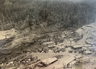
Photograph - Aerial View of Bogong Alpine Village
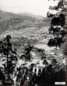
The images in the Bogong Village Collection were displayed in Bogong Jack’s Tavern for over 20 years and were donated to the Falls Creek Museum when the Tavern closed in 2021. In 1939, the State Electricity Commission of Victoria established a field headquarters at Bogong to house workers and their families for the Kiewa Hydroelectric Scheme which ran from the 1930s to the 1960s. The workmen's camp was originally started with tents and was called Junction Camp. By 1947, the village supported 300 workers and their families. It included 40 houses, a hostel for single staff, a post office, a police station, a medical centre, and a primary school. The staff hostel was known as Kiewa House. At the completion of the Scheme, in the 1960s, the village was opened to public/tourism use. In 1968 the Victorian Education Department acquired the camp buildings and four houses from the State Electricity Commission of Victoria to establish an Outdoor Education Centre which operated for over 50 years. The Kiewa Hydroelectric Scheme was privatized in the 1990s and sold to Southern Hydro, before being acquired by AGL in 2005. In 2023 the Grollo Group signed a 73 year sublease on Bogong Village and has plans for its redevelopment as a workers’ village.These images are significant because they capture the development of Bogong Village as an important element of the Kiewa Hydroelectric Scheme in Victoria.An aerial view of Bogong Village and surrounds, date unknown.bogong alpine village, bogong high plains, aerial photos bogong village -
 Falls Creek Historical Society
Photograph - Bogong Alpine Village 1940
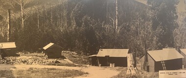
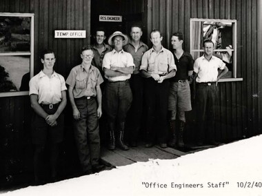
The images in the Bogong Village Collection were displayed in Bogong Jack’s Tavern for over 20 years and were donated to the Falls Creek Museum by the Liz Krien & the Bogong Village Trust Board when the Tavern closed in 2021. In 1939, the State Electricity Commission of Victoria established a field headquarters at Bogong to house workers and their families for the Kiewa Hydroelectric Scheme which ran from the 1930s to the 1960s. The workmen's camp was originally started with tents and was called Junction Camp. By 1947, the village supported 300 workers and their families. It included 40 houses, a hostel for single staff, a post office, a police station, a medical centre, and a primary school. The staff hostel was known as Kiewa House. At the completion of the Scheme, in the 1960s, the village was opened to public/tourism use. In 1968 the Victorian Education Department acquired the camp buildings and four houses from the State Electricity Commission of Victoria to establish an Outdoor Education Centre which operated for over 50 years. The Kiewa Hydroelectric Scheme was privatized in the 1990s and sold to Southern Hydro, before being acquired by AGL in 2005. In 2023 the Grollo Group signed a 73 year sublease on Bogong Village and has plans for its redevelopment as a workers’ village.These images are significant because they capture the development of Bogong Village as an important element of the Kiewa Hydroelectric Scheme in Victoria.A collection of 10 black and white images capturing the development of Bogong Alpine Village. They depict development of the new village, the surrounding area and some staff members during 1940.bogong alpine village, bogong 1940, bogong high plains -
 Falls Creek Historical Society
Photograph - Bogong Alpine Village 1943
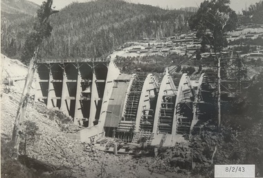
The images in the Bogong Village Collection were displayed in Bogong Jack’s Tavern for over 20 years and were donated to the Falls Creek Museum when the Tavern closed in 2021. In 1939, the State Electricity Commission of Victoria established a field headquarters at Bogong to house workers and their families for the Kiewa Hydroelectric Scheme which ran from the 1930s to the 1960s. The workmen's camp was originally started with tents and was called Junction Camp. By 1947, the village supported 300 workers and their families. It included 40 houses, a hostel for single staff, a post office, a police station, a medical centre, and a primary school. The staff hostel was known as Kiewa House. At the completion of the Scheme, in the 1960s, the village was opened to public/tourism use. In 1968 the Victorian Education Department acquired the camp buildings and four houses from the State Electricity Commission of Victoria to establish an Outdoor Education Centre which operated for over 50 years. The Kiewa Hydroelectric Scheme was privatized in the 1990s and sold to Southern Hydro, before being acquired by AGL in 2005. In 2023 the Grollo Group signed a 73 year sublease on Bogong Village and has plans for its redevelopment as a workers’ village.These images are significant because they capture the development of Bogong Village as an important element of the Kiewa Hydroelectric Scheme in Victoria.A collection of seven black and white images capturing the development of Bogong Alpine Village and the Pretty Valley area during 1943.bogong alpine village, bogong high plains, bogong 1943 -
 Falls Creek Historical Society
Photograph - Bogong Alpine Village 1942
The images in the Bogong Village Collection were displayed in Bogong Jack’s Tavern for over 20 years and were donated to the Falls Creek Museum when the Tavern closed in 2021. In 1939, the State Electricity Commission of Victoria established a field headquarters at Bogong to house workers and their families for the Kiewa Hydroelectric Scheme which ran from the 1930s to the 1960s. The workmen's camp was originally started with tents and was called Junction Camp. By 1947, the village supported 300 workers and their families. It included 40 houses, a hostel for single staff, a post office, a police station, a medical centre, and a primary school. The staff hostel was known as Kiewa House. At the completion of the Scheme, in the 1960s, the village was opened to public/tourism use. In 1968 the Victorian Education Department acquired the camp buildings and four houses from the State Electricity Commission of Victoria to establish an Outdoor Education Centre which operated for over 50 years. The Kiewa Hydroelectric Scheme was privatized in the 1990s and sold to Southern Hydro, before being acquired by AGL in 2005. In 2023 the Grollo Group signed a 73 year sublease on Bogong Village and has plans for its redevelopment as a workers’ village.These images are significant because they capture the development of Bogong Village as an important element of the Kiewa Hydroelectric Scheme in Victoria.A collection of four black and white images capturing the development of Bogong Alpine Village and the Pretty Valley area during 1942.bogong alpine village, bogong high plains, bogong 1942 -
 Falls Creek Historical Society
Photograph - Bogong Alpine Village 1941
The images in the Bogong Village Collection were displayed in Bogong Jack’s Tavern for over 20 years and were donated to the Falls Creek Museum when the Tavern closed in 2021. In 1939, the State Electricity Commission of Victoria established a field headquarters at Bogong to house workers and their families for the Kiewa Hydroelectric Scheme which ran from the 1930s to the 1960s. The workmen's camp was originally started with tents and was called Junction Camp. By 1947, the village supported 300 workers and their families. It included 40 houses, a hostel for single staff, a post office, a police station, a medical centre, and a primary school. The staff hostel was known as Kiewa House. At the completion of the Scheme, in the 1960s, the village was opened to public/tourism use. In 1968 the Victorian Education Department acquired the camp buildings and four houses from the State Electricity Commission of Victoria to establish an Outdoor Education Centre which operated for over 50 years. The Kiewa Hydroelectric Scheme was privatized in the 1990s and sold to Southern Hydro, before being acquired by AGL in 2005. In 2023 the Grollo Group signed a 73 year sublease on Bogong Village and has plans for its redevelopment as a workers’ village.These images are significant because they capture the development of Bogong Village as an important element of the Kiewa Hydroelectric Scheme in Victoria.A collection of four black and white images capturing the development of Bogong Alpine Village. They depict development of the new village, the surrounding area and some staff members during 1941.bogong alpine village, bogong high plains, bogong 1941 -
 Bendigo Historical Society Inc.
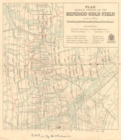
Map - DEPARTMENT OF MINES VICTORIA : PLAN SHOWING PORTION OF THE BENDIGO GOLD FIELD
... DEPARTMENT OF MINES VICTORIA : PLAN SHOWING PORTION OF THE...Department of Mines Victoria. Plan showing portion... J. J. Department of Mines Victoria. Plan showing portion ...Department of Mines Victoria. Plan showing portion of the Bendigo Gold Field. On the back is written, in ink, J. J. Tyler 1937 Northern Area. (He was a teacher at Bendigo High - see donation notes). Across the bottom of the map is written ' M. Hill cr. Myrtle & Barnard' .The named reef lines have been numbered with ink across the bottom of the map. The gullies have been coloured with green pencil and a red pencil line is drawn through the western side of the map. Additional information: anticlinal axial lines at surface, alluvial workings, shaft sites, area of Main Goldfield, Deepest mine workings, Gold output of field to 1935, and Dividends paid 1870 - 1935.bendigo, gold mining, bendigo gold field. gold mining. tyler, j. j. -
 Bendigo Historical Society Inc.
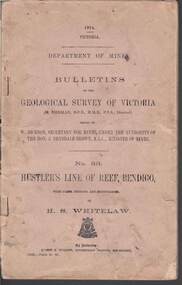
Book - STRUGNELL COLLECTION: DEPARTMENT OF MINES: 1914 GEOLOGICAL SURVEY OF VICTORIA. HUSTLERS LINE OF REEF, 1914
Book, Department of Mines, Bulletins of the Geological Survey of Victoria, No.33, Hustler's Line Of Reef, Bendigo, with plans,sections, and photographs, by H.S.Whitelaw. 13833, Price 2s.6d.`Back cover shows J.A. and J.A Strugnell , 12 Mulbar St Swan Hill 3585 .Albert J. Mullett, Government Printer, Melbourne.book, bendigo, hustler's line of reef -
 Glenelg Shire Council Cultural Collection
Plan - Plans / Line Drawings - Port of Portland Floor Plan layout and footings Marine Department depot, Victoria, n.d
PORT OF PORTLAND AUTHORITYFront: '6' black texta, top right corner -
 Bacchus Marsh & District Historical Society
Map, Bacchus Marsh Region Parish Plans: Folded set of maps
Set of Victorian Lands Department Parish Plans covering the township of Bacchus Marsh and surrounding districts. Folded. BMDHS Location: AR/SU27/D2: Map Drawersmaps bacchus marsh region, bacchus marsh victoria maps, interim record -
University of Melbourne, Burnley Campus Archives
Plan, E.T. Brear, Glenferrie Primary School - Library/Art Craft Upgrade, 1987
Public Works Department, Victoria. Glenferrie Primary School Library- Art/Craft Upgrade. Site Plan No 87-579 A1. Scale 1:500. Drawn by E.T. Brear on 30.3.87.glenferrie primary school, e.t. brear, hawthorn, victoria. public works department -
University of Melbourne, Burnley Campus Archives
Plan, Wilsons Promontory8119-I and Glennie 8119-IV, 1971
State Aerial Survey Plan of Wilsons Promontory and Glennie. Dated 1971. Provisional Compilation of Sheets 8119-I and 8119-IV from Commonwealth Department of National Development Photography for the Department of Crown Lands and Survey Victoria. Students made excursions to Wilsons Promontory.wilsons promontory, glennie group, anser group, bass strait, aerial survey -
University of Melbourne, Burnley Campus Archives
Plan, Garden Advisory Centre Summer House. Landscape working drawing 1:50, 1985
Copy of Landscape Working Drawing for the Agriculture Research Institute by the Public Works Department, Victoria No 85-523 L1/1 dated 30.01.1985. Scale 1:50.garden advisory centre, summer house, agriculture research institute, victoria public works department, landscape drawing, burnley gardens -
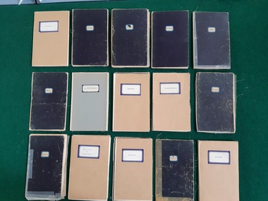
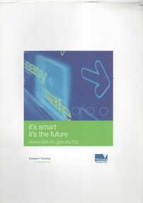 Melbourne Tram Museum
Document - Folder with papers, Transport Ticketing Authority, "it's smart - it's the future", Jul, 2005
Set of 8 documents in a white card folder July 2004 about the introduction of Victorian "Smartcard" ticketing system, published by the Victorian Transport Ticketing Authority. Used for a press handout. .1 - Printed card sheet folder to provide a folder with the title "it's smart - it's the future", published by the Authority. .2 - Press or Media Release - Premier of Victoria - 12 July 2005, issued by Steve Bracks, about the new ticketing system, and the companies involved and the basis of the proposed system. (two pages) .3 - News Release from Kamco - Keane Australia micropayment consortium - about the company and their proposals for the new system. ( 3 pages) .4 - Printed company information sheet about the companies involved - Keane Australia, Ascom AG, ERG Group and Giesecke & Devrient (G&D) (2 pages) .5 - Fact Sheet 01 - about the system, issued by the Authority about the proposals, tender period and the planned date for introduction. (1 page) .6 - Fact Sheet 03 - about the selection of KAMCO (1 page) .7 - Q&A sheet for use by operator staff in answering customer enquiries - about the system, KAMCO, costs, notes the end of Metcards and trials. (2 pages) .8 - Q&A sheet - what it means for you and your business? - about timing, fares and zones, staff training, Metcard, use and further information. (2 pages) Note: From Wikipedia accessed 1/1/2016 "The Transport Ticketing Authority (TTA) was a statutory authority within the Department of Transport in the State Government of Victoria, Australia. It was established in June 2003 to manage Victoria's interest in the OneLink Metcard public transport ticketing system contract, and to procure and manage the new ticketing system for Victoria, eventually known as myki. On 10 February 2010, the Minister for Public Transport replaced Gary Thwaites, chief executive of the Transport Ticketing Authority (TTA), with Bernie Carolan, the then head of Metlink.[1][2] On 1 January 2013, as the third stage of the implementation of the Public Transport Development Authority Act 2011, Public Transport Victoria assumed the responsibilities of the TTA,[3] which was formally abolished on 1 July 2013."trams, tramways, minister for transport, transport ticketing authority, myki, tickets, metcard -
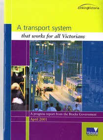 Melbourne Tram Museum
Book, Department of Infrastructure (DOI), "A transport system that works for all Victorians", Apr. 2001
Report or Book - 28 A4 pages, full colour centre stapled printed on gloss paper titled "A transport system that works for all Victorians", published as a progress from the Bracks Government, April 2001. Includes a message from Peter Batchelor. Looks at the forward planning for transport in Victoria, including various public transport projects.trams, tramways, planning, doi, m>tram, spencer st, public transport, railways -
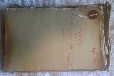 Melbourne Tram Museum
Document - Folder with papers, Public Works Department, "16/298 - Tramway Along Victoria St, Barkers Road and High Street to Burke Road", 1914 to 1916
Folder with papers or file with manila covers, secured with white cloth shoelace type retaining mechanism and red Bakelite type clips containing papers concerned with the construction of the tramway extension at Victoria Bridge (to run alongside the cable tram), the conversion of Kew Horse Tramway and construction of a new electric tramway to Burke Road - titled "16/298 - Tramway Along Victoria St, Barkers Road and High Street to Burke Road". Compiled by the Public Works Department of Victoria - generally dated 1914 to 1916 Shows the nature of the paperwork required for an Act of Parliament to authorise the work, orders in Council, drafts, actual copies of Parliamentary documents, letters to and from Councils, Members of Parliament, PMTT, plans, bridges and footpaths. Includes letters with the City of Collingwood, Kew and Richmond.trams, tramways, kew, high st, victoria st, bridges, collingwood, barkers rd, construction, cable trams, burke rd, pmtt, public works department, parliament -
 Melbourne Tram Museum
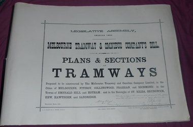
Document - Folder, Jack Cranston, "Melbourne Tramway & Omnibus Company's Bill - Plans and Sections - Tramways - March 1882", 1994
Consists of five sheets with notes about the proposed horse tram system for Melbourne, prepared by Jack Cranston. Includes extract and notes on the parliamentary enquiry and the possibility of a cable tram system. The coloured sheet is from another copy held at the former VicTrack Malvern Museum. Images from the latter set of documents - Sept 2024. 35 Sheets of details on the plans and sections of proposed horse tram lines throughout Melbourne. Produced as part of the work undertaken by Jack Cranston for the Department of Transport / Heritage Victoria - see Reg Item 584. On rear cover ink and on page 2 of the folder is a note on the source of the document. See Inscriptions.Yields information about the proposed horse tram lines by MTOCo that were later developed as cable tram lines.Folder - photocopies or copy prints, A1 approx. size, 45 sheets, clipped together with two black side binders, titled - "Melbourne Tramway & Omnibus Company's Bill - Plans and Sections - Tramways - March 1882". On rear cover sheet, handwritten in black ink - "Constructed and compiled by Jack Cranston by permission from The Ambleside Museum Ferntree Gully Victoria. This is a copy of Original Size Folio"trams, tramways, cable trams, horse trams, mto co, melbourne -
 Melbourne Tram Museum
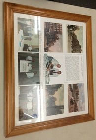
Photograph - Framed Photographs, Department of Transport, "Presentation of an Essay to the Department of Transport Victoria, March 1994", Mar. 1994
Set of 9 postcard, document or images framed with a wooden frame at the time of the "Presentation of an Essay to the Department of Transport Victoria, March 1994". Has a white backing for postcards and photos, approx. 145 x 100. Items have been placed it appears on an under backing. Glazed, craftwood backing secured with staples into the frame. On the rear has a printed label with a red border on white paper with the number "27" in black. From Top left to bottom right: , Postcard of Swanston St with St Pauls, Note about the presentation and the work undertaken by Jack Cranston, Postcard of Queens Bridge Melbourne, looking north from the south side of the Yarra, Postcard of Flinders St, Photo of Jack Cranston with Minister for Transport, Alan Brown MP, Postcard of Collins St Melbourne, Photo of presentation party - Jack Cranston, Con O'Carroll, Robert Wilson, Graham Jones, Robert Green, John Keating and Alan Brown., Photo of Alan Brown, Jack Cranston and Kim Wells holding the Plans and Sections folder (see Reg Item 583)., Photo of Alan Brown and Jack Cranston.trams, tramways, cable trams, horse trams, mto co, melbourne -
 Bendigo Historical Society Inc.
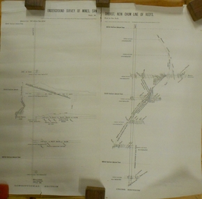
Plan - MARKS COLLECTION: UNDERGROUND SURVEY OF MINES SANDHURST NEW CHUM LINE OF REEF
Plan, divided into two sheets, on top of sheet Underground survey of mines Sandhurst, New Chum Line of Reef. Surveyed by Caleb Thomas under the direction of Charles W. Langtree, Acting Secretary for Mines and Water Supply and Acting Chief Mining Surveyor for the Colony of Victoria. Drawn by Arthur Everett, Mining Department, Melbourne, 1884.bendigo, mining, new chum line of reef -
 Department of Energy, Environment and Climate Action
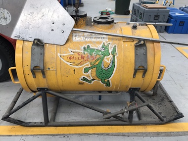
Aerial Drip Torch (ADT) or "Dragon"
The Aerial Drip Torch (ADT) was an idea conceived in Canada in the 1970s by John Muraro It was developed in 1982 by the New Zealand Forest Service to become the Ashley Aphid Helitorch. Forestry Tasmania acquired one of the machines and modified it in February 1987. Also known as a dragon helitorch it consisted of a large 135-litre tank containing jellied petrol, a displacement pump, propane ignition system, burner nozzle and fire extinguisher system. It was first trialled in Victoria at Swifts Creek in 1991 and the Aerial Drip Torch (ADT) has now become standard practice.Two Aerial Drip Torches (ADTs) were built in the 1990s by the Fire Equipment Development Centre at North Altona, They were developed in conjunction with the Department of Conservation and Land Management in Western Australia. The first was trialled during the 1991/92 autumn burning season. The machine proved to be successful and a second machine was introduced in 1998 to assist with burning operations across the State. The ADTs were commonly used for regeneration burning (controlled burning of logging slash). The first ADT introduced in 1992 had a dry weight of 160kg and a capacity of 130 litres, providing about an hour of operation. Following initial use, systematic modifications were adapted including improved ignition of gel at the drop tube, installation of an air bleed valve at the pump to assist pump priming and improved mounting brackets for the CO2 bottles and propane canister attached to the machine. The second, and lightweight ADT, introduced in 1998 had a dry weight of 68kg and a capacity of 200 litres due to a smaller lightweight frame and plastic (Polyfin) tank. In operation the ADT is suspended below a helicopter via four strops attached to the vessel and a cable to the helicopter cargo hook. Gelled fuel is dispensed via a drop tube which is attached to the pump outlet of the machine, and ignited via a gas torch. Safety features built into the first ADT were: a brass melting plug designed to be activated at 200 C bursting disc designed to burst at170 Kpa should the vessel over pressurise. a pressure relief valve set to 35 Kpa ( vessel operated between 16 &34 Kpa) a low pressure sensor designed to shut down the machine should the vessel pressure drop below 15Kpa. the vessel is filled with CO2 above the gelled fuel to eliminate ignition with in the vessel. CO2 is used to expel any residue of ignited gel from the drop tube to prevent ignition when flying outside the boundaries of the burning area. See FIRE EQUIPMENT NOTE - 46 [ https://drive.google.com/file/d/1CKtcH-3rUlrtbE9dkNP27PYT2-raVVhF/view ]forests commission victoria (fcv), bushfire, bushfire aviation, planned burning -
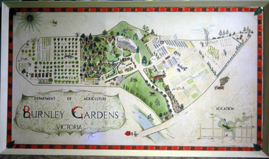 University of Melbourne, Burnley Campus Archives
Album - Colour print, colour 35mm slide, CD, Picture of Plan of Burnley Gardens, 1965
(1) Photograph of hand drawn and coloured framed picture of Burnley Gardens which used to hang in the passage in the Administration Building (missing). (2) CD of picture. (3) Postcard of picture, "Department of Agriculture Burnley Gardens Victoria". On reverse, "VCAH Horticultural College Centenary 1891-1991 Burnley". "Name Alan Gilbert Dept Vice Chancellor The University of Melbourne Parkville Victoria 3052"burnley gardens, administration building, vcah, horticultural college, centenary, alan gilbert, a l mitchel, plan of site -
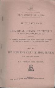 Bendigo Historical Society Inc.
Book - MINING REPORTS - THE CONFIDENCE GROUP OF MINES BULLETIN NO 41
Light brown covered booklet 'Bulletins of the Geological Survey of Victoria issued by W Dickson, Secretary for Mines, Under the Authority of the Hon. S Barnes M L A Minister of Mines. No 41 The Confidence Group of Mines, Bendigo with Plans and Sections by H S Whitelaw, Field Geologist, dated 1918. Mines mentioned are: Confidence Extended Mine, Confidence Tribute Company and the Central Windmill Hill Mine. Mentioned in the report are crushings and gold yield, details of levels, names of leases along the reef. Extracts from Mine Manager's Half-yearly Reports, 1878-1915 of tons crushed and gold yield. Plans and sections of the Confidence Extended Mine on the Garden Gully Line of Reefs are: Plate I General Plan of All Levels, Plans of Levels Plate No II, Plans of Levels Plate No III, Transverse Section Plate No IV, Longitudinal Section Plate No V, and Central Windmill Hill Mine Transverse Section Plate No VI. Plates signed by H S Whitelaw 17 & 18/6/16 and 20/7/16. Booklet if part of the Albert Richardson Collection. book, bendigo, mining reports, mining reports, the confidence group of mines bulletin no 41, confidence extended mine, confidence tribute company, central windmill hill mine, department of mines, bulletins of the geological survey of victoria, w dickson, the hon s barnes, h s whitelaw, h j green, mr robert eddy, mr w h cundy, j foster, c j thompson -
Lakes Entrance Historical Society
Book, Victoria Buildings and Builders - Gippsland, 1998
Architectural drawings by Victorian Public Works Department. Lists plans of many public Buildings in Gippsland, and illustrates examples of schools, courthouses and Latrobe Bridge. Contains bibliography.architecture -
Lakes Entrance Historical Society
Book, Department of Conservation and Natural Resources, Draft Gippsland Lakes Fisheries, 1995
Draft management plan inviting comments from all user groups of the Gippsland Lakes Victoriafishing industry, recreation, birds