Showing 599 items matching "weir"
-
 Federation University Historical Collection
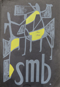
Booklet, J.A. Hoskin & Son, Ballarat School of Mines Students' Magazine, 1946, 1946
Ballarat School pf Mines Council, Members of Staff, List of Full Course Students' 1946, Magazine Committee, Editorial, Editor's Notes, News and Notes, Obituary - W. S. Stuckey, The Head - A. F. Heseltine, Staff 1946, The Literary Society, Science Section, Art Section, S.M.B. Sports Committee 1946, Senior Sport, Commercial Notes, Preparatory Girls, Junior Technical School Section, Junior Technical School Ballarat Students' 1946,White and yellow front soft covered magazine with green and blue font. 92 pages including advertisements.ballarat school of mines, magazine, j. walter, k. whiter, k. bremner, d. spence, n. reave, p. banfield, r. sudholz, n. lumsden, j. procter, p. wilson, j. jolly, s. parker, j. mckenzie, b. burgess, p. maloney, f. daykin, m. mcleod, dr. j. r. pound, p. marxsen, f. g. procter, c. fairbank, d. williams, c. hoffman, t. trengrove, n. t. bunning, d. t. kellock, a. f. heseltine, cr. h. l. coburn, gwen spiers, max berlyn, dr. h. hirst, w. s. stuckey, e. j. mcconnon, f. l. collins, a. w. bridson, j. j. hanrahan, h. brew, g. w. cornell, j. t. collins, r. w. whitla, s. mayo, n. bunning, l. o. brown, g. v. bergin, r. r. watson, t. kellock, a. j. murdoch, r. w. richards, a. c. miller, a. v. gilpin, t. r. gordon, r. p. flower, h. yates, d. mullins, w. wilkinson, l. hillman, a. johnson, a. jones, m. fogarty, h. darby, j. allsop, w. paterson, a. lambert, h. goldsmith, m. mctaggett, c. king, m. harland, n. w. penrose, r. r. calder, s. williams, c. f. jeffrey, d. i. johnston, j. sutherland, r. h. lonie, f. e. ferguson, b. law, j. lochhead, david coburn, peter marxsen, jack scala, kingsley bremner, douglas dean, alan wison, doris pengalley, roma sudholz, ken palmer, winnie beckwith, tonie hilton, jean waller, david hobson, w. rowe, john procter, neville reeve, joan walter, robert allen, mrs smail, betty young, william blackie, alfred mckenzie, peggy crosbie, dawn williams, lloyd lehmann, j. waller, p. crosbie, w. beckwith, w. stevens, o. whitworth, d. harper, d. judd, j. blainey, d. coburn, r. mawby, m. connell, i. mclachlan, d. dean, r. holliocke, d. jelbart, f. savage, b. hewitt, m. murray, g. sewell, l. pattenden, n. morton, w. wray, b. sherritt, r. jillet, n. hornbuckle, j. sewell, m. walsh, m. ross, m. james, n. sewell, r. gladman, n. pitcher, h. duncan, p. gleeson, edna stevens, reita rowe, rosemary gillett, roy mawby, kevin whiter, robert morgan, don lucas, laurie krausgrill, j. hanrahan, w. sutherland, b. bowman, l. clifton, w. coad, i. james, k. eberhart, g. jukes, k. dean, k. george, r. montgomery, t. aggett, r. hocking, m. grinham, m. lawless, k. cartledge, g. clifton, d. halson, g. hindson, w. haire, r. sargent, m. mccarthy, a. spicer, w. nunn, m. tweedale, ronald healey, howard mcwilliam, l. weir, r. watson, gilbert j. troplis, l. wilson, k. spalding, k. east, w. holdsworth, e. jackson, j. anderson, t. shaw, w. whittle, d. morris, w. fisher, g. toplis, a. hughes, w. coles, f. atchison, f. gallagher, t. hewitt, a. ward, w. hon, r. lambert, w. brogden, r. farquhar, j. james, l. keen, i. wilson, s. h. jones -
 Federation University Historical Collection
Magazine - Booklet, Ballarat School of Mines Students' Magazine, 1962, 1962
Ballarat School of Mines Students' Magazine, 1962. Editorial, Prominent Personalities, The Principal's Pages, The Richard W. Richards Medal, The Challenge, Camera Portraits, Conferring of Diplomas, The Highest Distinction - the F. J. Pomeroy Cup, What is Mathematics?, Microliths, Begonia Festival Procession, In a Man's World, Retirement of Mr. Harold Yates, The Eric McGrath Award, Asian Students in the S.M.B., Austral-Asian Relationships, Originality - At What Price?, Sports Awards 1962, Sports, The BEAT Generation, University in Ballarat, Heads of Departments 1873 - , Associates Black soft cover with grey inscriptions and grey and yellow figures on front cover, 72 pagesOn one of the first two loose pages there is the inscription "Copy uncollected by student but paid for, used to cut our advertisers' copy, 15/08/63".ballarat school of mines students' magazine 1962, staff, sports, stanley white, kelvin whitford, eric mcgrath, ian weir, gordon johnson, kerry penna, kevin oscar rogers, robert coutts, graeme waller, anita bitans, noel kelly, john davis, tony brauer, sue davies, h. e. arblaster, w. h. reimann, a. j. bethune, william peter john huberts, d. pollard, john boermans, james william beattie, edward westlake doney, john maxwell gilbert, barbara anne o'conell, helen margaret ross, robert william tantau, jeffery murrell, barry thomas dunstan, juris erdmanis, sr. mary andre power, james william john, walter henry reimann, donald james stewart, ronald william furlong, kenneth joseph howard, allan graham rock, robert geoffrey champneys, denis richard colbourn, wilhelmus peterus johannes huberts, neil herbert andrews, john barry gillick, charles edwin goddard, donald william pope, william henry saggers, ronald charles davis, travers william duncan, brian thomas hickey, robert reginald archer, kaspars bitans, robert william lochhead, tony white, teng seong khoo, robert frederic murrell, john william faulkner, harry w. goldsmith, h. darby, don holmes, j. r. pound, david james, ross gray, harold yates, w. l. moore, teddy gan, m. moissinac, c. gan, b. tanthiem, l. k. oh, b. eng, doug rash, d. holmes, t. c. poh, b. saw, s. wendt, p. malins, d. a. black, g. biddington, borom tanthiem, edward elsbury, w. lancaster, mount isa mines, eric mcgrath award, ballarat school of mines revue, electrolytic zinc companyof australasia limited, m.b. john, b. and g. myers, broken hill associated smelters -
Federation University Historical Collection
Reports, Unidentified Mammal Report, 1970-1990, 1970-1990
The folder or correspondence is the result of a Freedom of Information request made to the Department of of Conservation, Forests and Lands in 2011. The folder was collected for research being conducted by David Waldron.Folder of reports relating to "Big Cats", Thylacines, and other large predators sightings australian mythical animals collection, david waldron, thylacine, sassafras, peter monhorst, jodie hoey, kelvin smith, traralgon south, gormondale, bridgewater, g. mcclure, whorouly, albury, jim walker, andrea westcott, john dawson, nicole walsh, grampians, eddy scott, talbot, lancefield, kalorama, inglewood, gavin cerini, dereel, rosemary fernandez, brian walters, alexandra, unidentified mammel, romsey, bill butterworth, flowerdale, bob hoare, trafalgar, lyn demopolis, broadford, green gully, ian weir, noel pascoe, bruce carter, mount stirling, andrea cooper, stawell, yvonne shepherd, red hills, halls gap, jill reid, puma, w.r.c. hill, caelli -
 Federation University Historical Collection
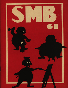
Booklet, Ballarat School of Mines Students' Magazine, 1961, 1961
Ballarat School of Mines Students' Magazine, 1961. Editorial, Prominent Personalities, The Principal's Pages, The Richard W. Richards Medal, Loyalty, Arts v. Science, Hong Kong Today, Conferring of Diplomas, Bath Push, Intellectual Pursuit, Never be a Woman, Man and Morality, The Old and the New, A Gentlemen's Excursion to Beaufort House, Awards 1961, Sports, The History of Electricity, School Council, Members of Staff, Roll Call Red front page soft cover with white inscriptions and black figures on front cover, 72 pagesballarat school of mines students' magazine, staff, sports, john w. boarmans, noel delosa, noel whitcher, bob coutts, noel kelly, les dobie, noel murphy, malcolm peel, peter agrums, ian weir, sue mole, val baker, neil bromley, kevin oscar rogers, h. e. arblaster, richard w. richards, daniel yung, m. b. john, morgan bevan john, sir william hudson, brian arthur bellingham, francis david benjamin, neil albert brogden, geoffrey angus chritian, william davison, brian harold duthie, thomas bernard gallagher, john robert gowan, william john spencer, lawrence grenville trevan, douglas james vendy, michael villani, walter john wynd, graeme robert bromley, david william brown, leonard ernest fox, ralph james hepburn, john gribble holloway, peter john matthews, peter mervyn robinson, chris peter livitsanos, david yan kai chung, thomas henry john coad, john neil mcarthur, john andrew watts, d. pollard, n. r. whitcher, peter agrumsk., e. ooi, t. smith, c. naylor, p. terry, gerald brenan, e. r. mcgrath, j. kavangh, a. bitans -
 Federation University Historical Collection
Book - Ledger, Ballarat School of Mines Rough Minute Book, 1917-1924, 1917-1924
Ledger book with rough minutes of the Ballarat School of Mines Councilballarat school of mines, ballaray school of mines council, minutes, ballarat school of mines council minutes, lancelot austin, returned soldiers, repatriation, maurice copland, h.h, smith, h.v. duncan, plumbing, fredeick martell, wildflower exhibition, factory day, william baragwanath, r. maddern, f. barrow, d. maxwell, w.h. middleton, w.h. humphreys, j.n. dunn, l. lederman, f. saunders, c.e. ludbrook, serjeant scholarship, james barrett, university college in ballarat proposal, a.s.m. polson, d. mclachlan, g. clarkson, w. guy, j. kean, miss poole, e.v. butler, brother keniry, h.b. berry, w.k. bolton, t. hurley, d. ronaldson, t.j. riddle, frederick saunders, r. stephenson, a.o. stubbs, s. weir, w.a. spring, james tulloch, museum -
 Federation University Historical Collection
Document - Documents - Reports, Notes for Staff: Ballarat Institute of Advanced Education, 1972
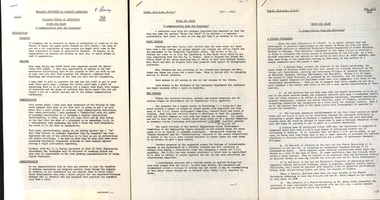
Ballarat Institute of Advanced Education is a predecessor or Federation University3 typed documents from the Ballarat Institute of Advanced Education 1972. .1 Notes for Staff including progress, welcome, administration, new staff appointments, student enrollments etc. .2 Notes for Staff including staff changes, new courses, past principals, enrollments, staff list etc. .3 Notes for Staff including a fourth university, tertiary finance, academic board etc. V. Barry written on top right hand corner of .1 & .2ballarat institute of advanced education, notes for staff, verna barry, e.j. barker, r.p. martin, b.r grainger, j.a.sykes, colin kline, roy schrieke, mark beverlander, ken clements, bill hitchins, lindsay pattenden, tom norwood, bill durant, student union, student residences, coburn and associates, jackson and walker, s.j. weir, mt helen library, albert medal, r.w. richards, anne mills, david ward, geoffrey lyle, rocky hazlett, ray martin, dave jelbart, zig plavina, allan ballard, pat hope, henry moritz, helen ross, roger bodenham, arch mckinnon, frank hogarth, harvey hooper, geoff barrell, jim thyer, john collier, lenore cox, fourth university, craftsmanship certificates, jenny burrell, jennifer hullick, r.w richards death, danny mullins, jack crosbie, harry nicholls, len taylor, library, graham hawley, jack barker -
Federation University Historical Collection
Ephemera - Promotional Material, Arts Academy End of Year Exhibition, 2018, 2018
The Arts Academy End of Year Exhibition is known as 'EYE'.Arts Society booklet, End of Year Exhibition invitation, student promotional material visual arts, myfanwy mclean, brittany brayshaw, toni hedger, beck davies, federation university art society, jill orr, ali dad afzali, malinda cracknell, jamilla cranny, libby mae drummond, brigitte halliwell, carley harris, tonu hedger, angela kenna, tahneil lakin, stephanie reggardo, sue weir, john wrigglesworth, eye, alumni -
 Maffra Sugarbeet Museum
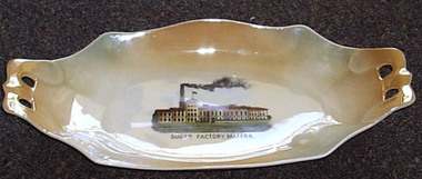
Souvenir Plate
A tangible reminder of how important the sugar beet factory and the sugar beet industry was to Maffra, is the production of souvenir-ware with images of the factory. The Sugar Beet industry was highly significant in the Maffra area for just under 50 years, and led to the construction of the Glenmaggie Weir and the consequent Macalister Irrigation District. The item lacks detailed provenance, but is obviously local.Oblong cream and tan souvenir plate with photograph of "Sugar Factory, Maffra" printed in centre. The ends are extended to form handles, each pierced with two holes.Sugar Factory Maffra [crown] / Victoria / China / Czechoslovakiasugarbeet -
 Maffra Sugarbeet Museum
Book, Cattle Feeding with Sugar Beets, Sugar, Molasses and Sugar Beet Residuum
Frank Pywell was manager of the Maffra Sugar Beet FactoryThe Sugar Beet industry was highly significant in the Maffra area for just under 50 years, and led to the construction of the Glenmaggie Weir and the consequent Macalister Irrigation District. This book is one of a number from the private library of the factory manager, and the entire collection of them provides a unique insight into information available at the time of manufacture. It is unlikely a collection of this breadth on sugarbeet is held anywhere else in Australia.Hardcover book "Cattle Feeding with Sugar Beets, Sugar, Molasses and Sugar Beet Residuum", 1902, 390 pages illus."F.J.Pywell" inside front cover "R.J. Shingles" page preceding title page. Stamp "Technical Library / Department of Agriculture / Melbourne" in several placessugarbeet -
 Bendigo Historical Society Inc.
Newspaper - LONG GULLY HISTORY GROUP COLLECTION: BENDIGO'S CENTURY VOLUME THREE: 1920 - 1929
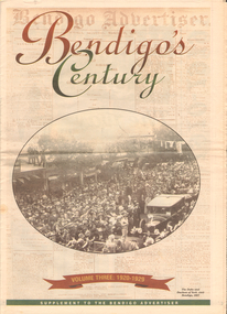
Newspaper supplement titled Bendigo's Century Volume Three: 1920 - 1929. Front page has a photo of The Duke and Duchess of York visit to Bendigo, 1927. Each year has heading of Who's Who, Weather, Sport and Business. First years are 1910 - 1919 titled The way we were. 1920 is titled Prince hailed. 1921 - City racks up a milestone. 1922 - Furore erupts. 1923 - Felons escape from city gaol. 1924 - Bid to finish RSL memorial. 1925 - Foul odour over sewerage plan. 1926 - Lest we forget Bendigo's fallen. 1927 - Royal Visit captures city. 1928 - Four shot in farm tragedy. 1929 - Billie's trip to remember.bendigo, history, long gully history group, the long gully history group - bendigo's century - volume three: 1920 - 1929, bendigo advertiser, duke and duchess of york, cr e m vains, r putnam, a j taylor, j h jackson, w crowley, sandhurst football club, george lansell, st peter's church, bendigo junior technical school, prince of wales, unity mine, mr w wilson, badak tin mining syndicate, mr t w ortonmr h scarborough, mr raleigh, general sir w r birdwood, the soldiers' memorial committee, bendigo city council, rsl memorial hall, captain g c wilson, lietenant r j parer, lieutenant j c mcintosh, cr j p carolin, h k morris, e a morris, turf tavern hotel, rev donald baker, all saints' pro--cathedral, keck's nursery, bendigo amalgamated goldfields, rising sun hotel, leanne mcdonnell, most rev john mccarthy, sir john quick, prime minister billy hughes, state rivers and water supply commission, diptheria, edna stevens, bendigo railway workshops, watson sustenance fund, sir joseph cook, dr lanza, bendigo amalgamated goldfields, bendigo benevolent asylum, miner's phthisis, bendigo gas company, electric light company, bendigo sewerage authority, commonwealth bank, cr curnow, the earl of stradbroke, dame nellie melba, princess theatre, lt-col g hurry, h sw lawson, countess of stradbroke, clunes woollen mills, girton college, mrs polglaise, mrs kennedy, gold discovery memorial, cr m g giudice, victorian co-operative freezing company, bendigo brick and tile company, mr lawson, soldiers' memorial, windermere hotel, toni riley pharmacy, bendigo gaol, mr a a dunstan mla, new red white and blue mine, claude de vere, walter osborne, sir john and lady quick, jonathan smalley, bendigo advertiser, st paul's bells, mr t cambridge, epsom public hall, bendigo school of mines, major lansell, mr h s w lawson, cr david andrew, colonel hurry, mr s bruce, bendigo sewerage authority, eppalock weir scheme, bendigo football league, r s l memorial, major g v lansell, lempriere, mr s m bruce, sandhurst hotel, market square, big hill tunnel, bendigo football league, bendigo united cricket club, south bendigo rex, sacred heart cathedral, hercules mine, gillies, aids & appliance shop, anne caudle centre, fizelle & mulqueen, south new moon mine, bendigo sewerage authority, mr a a kelley, epsom sewerage works, white hills botanical gardens, mr j sternberg mlc, bendigo book of remembrance, bendigo football league, senator general drake-brockman, captain dyett, school of mines, handschin and romus, hanro (aust.) bendigo knitting mills, charles handschin, farmers' union, andrew sunstan mla, country progressive party, john allan, captain g j c dyett, eahlehawk ufs dispensary, data fundamentals, the duke and duchess of york, the hercules mine, cr j a michelsen, lansell family, bendigo agricultural society, huntly shire council, bendigo creek trust, south african war memorial, cr j h curnow, st paul's church of england diamond jubilee, bendigo chamber of commerce, bendigo freezing works, bendigo pottery, bendigo trotting club, new red white and blue mine, the conservatory, cr e g batchelder, hercules mine, billie rigby, bendigo railway station, travellers' aid society, eppalock weir, the state rivers and water supply commission, bendigo railway workshops, frank grove, cr curnow, electric supply company, state electricity commission, australian aero club, bendigo preserving company, jardine, busbridge, feeman, mr h pearce, bfl, fred wood -
 Bendigo Historical Society Inc.
Newspaper - LONG GULLY HISTORY GROUP COLLECTION: BENDIGO'S CENTURY VOLUME FOUR: 1930 - 1939
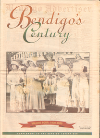
Newspaper supplement titled Bendigo's Century Volume Four: 1930 - 1939. Front page is titled Bendigo's Century and has a photo of some women at the Bendigo Jockey Club, 1930s. Each year has heading of Who's Who, Weather, Sport and Business. First years are 1930 - 1939 titled A look back when. The page has photos of the Eaglehawk Cricket Club's first A Grade cricket premier ship team (1932 - 1933)., The monument to the late Bendigo mining magnate Ernst Mueller in Rosalind Park, The Bendigo Stock Exchange in the early 1930's - pictured are L L Dungey, T Williams, M P Kelly, C Mueller, E Hommoloff, R Kelly, T H Busst, T Hall, R Trembath, E A Woolcock, and C Burridge, the Carshalton mine in 1936 and The Edith and G V Lansell Laboratory at the Bendigo Hospital. 1930 - a photo of St Andrew's Church, the sundial outside the RSL Memorial Hall, The late Monsignor Rooney and The late John Douse Langley. The Ironbark Mine was the top gold producer. 1931 - Radio station goes on air, 1932 - Sir John dies, 1933 Bodyline men come to town, 1934 - Heroic rescues, 1935 - Hospital's new wing opened, 1936 - King mourned, 1937 - Beehive store towers above, 1938 - Mining shows mixed results and 1939 - Outbreak of war sobering.bendigo, history, long gully history group, the long gully history group - bendigo's century - volume four: 1930 - 1939, eaglehawk cricket club, ernst mueller, the bendigo stock exchangel l dungey, t williams, m p kelly, c mueller e hommoloff, r kelly, t h busst, t hall, r tremabath, e a woodcock, c burridge, charshalton mine, edith and g v lansell laboratory, st andrew's church, rsl memorial hall, mr gordon carter, sir john monash, state electricity commission, cr r watson, colonel gt v lansell, empire press congress, bendigo advertiser, mr e j hogan, eppalock weir, lyric theatre, bendigo red cross, mrs george mackay, st andrew's presbyterian church, mrs william hunter, right rev john douse langley, monsignor rooney, bendigo art gallery, the ironbark mine, coliban water, mr w wright, station 3bo, amalgamated wireless of australia ltd, advance bendigo group, the north league, st aidan's orphanage, bendigo freezing works, mr w wright, bendigo advertiser, mr w j stephens, advance bendigo group, north league, garden gully united gold mining company, bendigo football league, sir john quick, john quick snr, ironbark foundry, bendigo evening news, bendigo independent, bendigo advertiser, deakin governmnet, sir charles kingsford smith, southern cross, eppalock weir, bendigo art gallery, the hercules mine, gillies, aids & appliance shop, anne caudle centre, bill woodfull, harold larwood, dr john mccarthy, the hercules, douglas jardine, don bradman, sacred heart cathedral, joseph stapleton, john lynch, bert mcconchie, new red white and blue mine, royal humane society, william james, vernon shaw, south new moon mine, bendigo hospital, bendigo base hospital, duke of gloucester, rsl memorial hall, electricity commission, eaglehawk borough council, the plaza, backhaus estate, amalgamated freezing company, fortuna villa, mrs edith lansell, colonel lansell, the hercules mine, toni riley pharmacy, boardwalk, barkly hyett, the big blue consolidated company, the bendigo hospital, eaglehawk football team, kurmala wing of the bendigo base hospital, sir isaac isaacs, lyric theatre, sir john quick, hanro knitting mills, st luke's toddlers home, st aidan's orphanage, rsl memorial hall, lord and lady huntingfield, cr michelsen, bendigo art gallery, bendigo agricultural show, new blue mine, joseph stapleton, bendigo law association, bendigo hospital committee of management, bendigo rotary club, mr j mcrae, education department, andrew sunstan, sir stanley argyle, bendigo football league, north blue mining company, cr staples, king george v, king edward viii, cr j a michelsen, andrew mclay, bendigo advertiser, cohn bros, mrs wallis simpson, king george vi, capping mine shafts 1936, bendigo art gallery, madge freemen, william john leslie cross, judge wasley, the myer emporium, the baptist church, salvation army, ron masters, the central nell gwyn, sir john quick, leanne mcdonnell, windermere hotel, rev donald baker, john rumbold, central nell gwynne, the beehive building, the beehive store, james buick and co, thomas hope henderson, buick henderson & co, mr goodison, mr r o henderson, lt-col henderson, angus mackay, bendigo sewerage authority, mr s gordon moore, commercial bank of sydney, bendigo advertiser, edward alan morcom, polio, dr gardner kerr, the right rev conald baker, ridley theological college -
 Bendigo Historical Society Inc.
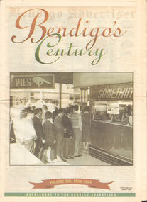
Newspaper - LONG GULLY HISTORY GROUP COLLECTION: BENDIGO'S CENTURY VOLUME SIX: 1950 - 1959
Newspaper supplement titled Bendigo's Century Volume six: 1950 - 1959. Front page has a photo of Gillies' famous corner, 1954. Each year has heading of Who's Who, Weather, Sport and Business. First year is 1950 titled Gillies: it's a Bendigo icon. 1951 is titled It's party time. 1952 - City mourns King George. 1953 - Mining ceases. 1954 - City thrilled at royal visit. 1955 - Push to save old Joss House. 1956 - Olympic fever grips Bendigo. 1957 - State Cabinet visits Bendigo. 1958 - Plan to keep historic mine. 1959 - Water storage woes solved. Back page has the Gillies Story.bendigo, history, long gully history group, the long gully history group - bendigo's century - volume six: 1950 - 1959, gillies' corner, bendigo advertiser, john lienhop mlc, north deborah mine, les gillies, alan gillies, norm gillies, black swan hotel, sir dallas brooks, cr a g weynton, bert mundy, cr poulston, the northern district school of nursing, lister house, the bendigo free library, rev dr c irving, shamrock hotel, sir albert dunstan, the most rev dr john mccarthy, jack davey, 1950 empire games, hercules gold mines, amy castles, ben templeton, cobb & co, cr norman oliver, reg parker, fred amer, les hammer, colonel george victor lansell, john quick, mr l w galvin, mr p j clarey mhr, hanro knitting mills, flooding, bendigo pottery, snow fall, the last lamp-lighter, the north deborah, aids & appliance shop, boardwalk, the late king george vi, the north deborah, beehive building, st paul's, st kilian's, upper reserve, bendigo trades hall, bendigo blackout, bendigo hospital, shamrock hotel, gerald smith, britannia hotel, mr a j harris, william morris (billy) hughes, andrew hampson, deborah anticline, north deborah, central deborah, diamond hill mine, north nell gynne mine, robert ross haverfield, sandhurst commercial courier, arthur moore lloyd, robert ross haverfield, angus mackay, jj casey, james henderson, david stuart, bendigo independent, colonel george lansell, bendigo base hospital, bendigo town hall, victorian electric traction association, the most rev b d stewart, st vincent's memorial college, commonwealth athletic club, south atlas racetrack, harp and shamrock hotel, mr and mrs f drake, cr f w clayton, cr r poulston, j h abbott & co, sir george lansell, clan macleod, bendigo gaol, queen alexandra fountain, belfast hotel, commonwealth bank, st vincent's college, lyric threatre, des duguid, brian cahill, lord's raceway, red white & blue extended gold mining company nl, central napoleon gold miningcompany nl, joss house, harry john, bendigo advertiser, mr leggatt, university of melbourne, anz bank, golden drive-in theatre, bank of australasia, john brown industries, bendigo football league, bendigo trotting club, faith leech, racv, bendigo sewereage authority, bendigo base hospital, bendigo benevolent asylum, henry bolte, jack davey, russell oakley, neville stilwell, channel seven, bendigo's olympic pool, annie caudle centre, strathfieldsaye aerodrome committee, southern airlines, cr d j osborn, cairn curran reservoir, state savings bank, commonwealth bank of australasia, belfast hotel, bennett's arcade, eppalock weir, bendigo cenotaph, sir edmund herring, cr a s craig, bendigo creche, bendigo high school, bendigo pottery, shamrock hotel, the venerable ronald richards, bishop riley, all saints cathedral, mr albert bush, bendigo arcade company ltd, woolworths, bull's head hotel, pike's corner, arcade hotel, upper coliban reservoir, cr tom flood, crystal egg co, sailor's guide, central deborah, central nell gwynne mine, bendigo benevolent home, ron masters, george daniel, eppalock dam, water commission, public works committee, bendigo central victoria telecasters ltd, channel nine, royal princess theatre, sir george lansell, volunteer defence corps, bendigo independent, countess erna cadorin, count ettore cadorin, ernst mueller, sutex pty ltd, dick turner, marco cavasassi -
Tatura Irrigation & Wartime Camps Museum
Photograph, 1936/02
Photo taken by the photographer for Victoria State Rivers and Water Supply CommissionMedium sized black and white photograph. Eildon Reservoir spillway / Concrete structure centre / rock and earth fill dam wall top half / round concrete tower left midway along wall bank.goulburn, irrigation, photo, victoria state rivers and water supply commission, eildon, eildon weir -
Tatura Irrigation & Wartime Camps Museum
Photograph, 1936
Photo taken by the photographer for Victoria State Rivers and Water Supply CommissionMedium sized black and white photograph. Eildon Reservoir dam wall / rock and earth fill wall from above / round concrete tower lower left / water above right / tree covered hill topgoulburn, irrigation, photo, victoria state rivers and water supply commission, eildon, eildon weir -
Tatura Irrigation & Wartime Camps Museum
Photograph, 1936
Photo taken by the photographer for Victoria State Rivers and Water Supply CommissionMedium sized black and white photograph. Eildon Reservoir overall picture - Original reservoir and dam / rock and earth fill dam wall and construction huts left of centre / trees foreground / tree covered hills top left and across top / dam water / with leisure craft near wall.goulburn, irrigation, photo, victoria state rivers and water supply commission, eildon, eildon weir -
Tatura Irrigation & Wartime Camps Museum
Photograph, Goulburn Irrigation System, 1970s
Taken by photographer for State Rivers and Water Supply Commission.Medium sized black and white photograph. Map showing the Goulburn Irrigation System in Northern Victoria including Eildon Reservoir, Waranga Reservoir, Eppalock Reservoir, Eppalock, Cairn Curran, Laancoorie, Tullaroop Reservoirs, the Stuart Murray, Cattanach Canal, East Goulburn Main and Waranga Western Channels.goulburn weir, victorian state rivers and supply commission -
Tatura Irrigation & Wartime Camps Museum
Photograph, May, 1888
Taken by photographer for State Rivers and Water Supply Commission.Medium sized black and white photograph. Wooden trestles across river - coffer dams on left fallen timber foreground lying in water of the river bed.goulburn weir, victorian state rivers and supply commission -
Tatura Irrigation & Wartime Camps Museum
Photograph, 19/12/1946
Taken by photographer for State Rivers and Water Supply Commission.Medium sized black and white photograph. Waranga Reservoir main outlet - Western main channel looking downstream to Waranga. Concrete bridges and control structure join earthen banks of channel. Windmill mid-left of picture.goulburn weir, victorian state rivers and supply commission -
Tatura Irrigation & Wartime Camps Museum
Photograph, 19/12/1946
Taken by photographer for State Rivers and Water Supply Commission.Medium sized black and white photograph. Waranga reservoir - rubble spray wall - 2'0" high - centre foreground - rail lines and trees on right mid picturegoulburn weir, victorian state rivers and supply commission -
Tatura Irrigation & Wartime Camps Museum
Photograph, 19/12/1946
Taken by photographer for State Rivers and Water Supply Commission.Medium sized black and white photograph. Centre picture: Horse drawn scoops dig clay from the borrow pit, and the central horse-drawn cart moves under the bridge to collect clay through an opening in the roof for transport to the embankment.goulburn weir, victorian state rivers and supply commission -
Tatura Irrigation & Wartime Camps Museum
Photograph, 1910
Taken by photographer for State Rivers and Water Supply Commission.Small black and white photograph. Earth embankment level being raised with clay hauled in scoops up the trestle ramp by horse-powered cable and pulleys. Workmen foreground right. Waranga reservoir. goulburn weir, victorian state rivers and supply commission -
Tatura Irrigation & Wartime Camps Museum
Photograph, 1910
Taken by photographer for State Rivers and Water Supply Commission.Small black and white photograph. Waranga Reservoir embankment (north end) man left of picture, looking towards narrow gauge railway line along which the beaching material is transparent from a nearby hill. Windmill left of centre and small boat and house right corner.goulburn weir, victorian state rivers and supply commission -
Tatura Irrigation & Wartime Camps Museum
Photograph, 1953
Taken by photographer for State Rivers and Water Supply Commission.Medium sized black and white photograph. Bucyrus Eric 6 yd. Walking Dragline - scoop filled with earth excavating channel.goulburn weir, victorian state rivers and supply commission -
Tatura Irrigation & Wartime Camps Museum
Photograph, 1950
Taken by photographer for State Rivers and Water Supply Commission.Medium sized black and white photograph. Gradall machine excavating trench for beachinggoulburn weir, victorian state rivers and supply commission -
Tatura Irrigation & Wartime Camps Museum
Photograph, 1953
Taken by photographer for State Rivers and Water Supply Commission.Medium sized black and white photograph. Foreground - Theodolite / Two men / Rock Crusher / Tractor pulling To construct earth fill bank at cattanach canalgoulburn weir, victorian state rivers and supply commission -
Tatura Irrigation & Wartime Camps Museum
Photograph, 1954
Taken by photographer for State Rivers and Water Supply Commission.Medium sized black and white photograph. Workmen laying rock beaching material on the earth fill bank of the cattanach canalgoulburn weir, victorian state rivers and supply commission -
Tatura Irrigation & Wartime Camps Museum
Photograph, 13/04/1918
Taken by photographer for State Rivers and Water Supply Commission.Medium sized black and white photograph. Eildon Reservoir overall picture / dam wall and construction huts left of middle / dam filled with water right of wall / tree covered hills beyond.goulburn weir, victorian state rivers and supply commission -
Tatura Irrigation & Wartime Camps Museum
Book, Nagambie Waterways The way they were, May 2009
History of the Goulburn Irrigation System and the waterways.Collection of early photographs of the area telling the history.Rectangular shaped book, Cover is a B/W photo of the 'Merriwee', boat, owned by W. L Forbes C 1920 with a group of people on board about to enjoy a sailing. There are 92 pages with many B/W photos detailing the history of the waterways.Credits page, supported by the Strathbogie Shire Council.and Nagambie Historical Society.irrigation history, lake nagambie, goulburn weir and environs, life in the area -
Tatura Irrigation & Wartime Camps Museum
Document, Lakeside Leisure, 1989
A guide to storages, features and facilitiesBlue cover with illustrations of activities associated with waterlakeside leisure, eildon dam, goulburn weir, waranga basin, tatura, document, pamphlets -
Tatura Irrigation & Wartime Camps Museum
Book, Harnessed Waters, 1989
Published on occasion of 50th Anniversary of completion of constructionCover showing photographs of stages in the construction on front. At back oval photo of two means of transport related to the areaharnessed waterstatura, construction of weir, formation of lake mulwala, construction, irrigation, books, history, local