Showing 2879 items
matching wellington
-
 Glenelg Shire Council Cultural Collection
Photograph - Sheet of 12 contact prints - Various Portland and local surrounds buildings and landmarks, c. 1970
Sheet of 12 contact prints of rephotographed photographs: Identifying numbers 5721 a, b, c, d, e, f, g, h, i, j, k, l (a) Fishing party, flat rocks Bridgewater (b) Dutton Way (c) Julia Street (d) Steam train (e) Bentinck Street corner (f) Bridge across Salt Creek 'Kingsley' in background (g) Bentinck Street railway station from Customs House (h) Yankee Doodle corner (i) Picnic on banks of river (j) Henty Bay (k) Man holding two bikes Wellington Road/Bentinck Street (l) same as (h) - Bentinck Street railway station from Customs House -
 Melbourne Tram Museum
Slide - Set of 3, Keith Caldwell, 11/3/1960
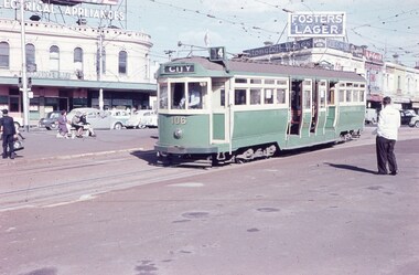
Set of 3 Agfa Colour slide, cardboard mount, by Keith Caldwell of 11 March 1960 of trams at St Kilda Junction. .1 - L 106 arriving at the junction from Wellington St. Tram has the destination of City, route 4. Signals for the trams can been seen on a pole on the left hand side of the photo. .2 - SW6 - as for .1 .3 - W3 668 ditto, from Fitzroy St, showing Moreland, route 15. Has an advert for 3AW. In the background in all photos are adverts for Speedie electrical appliances, Fosters Lager, Stonefell wines, Gilbeys Gin, Penfolds, Stockdale's Bread, Hamburger Max Snack bar, Ardath, Brooks Books.All hand stamped "11 Mar '60"; .1 "L" in ink and .3 "W3" in ink written on.trams, tramways, st kilda junction, signal box, l class, w3 class, tram 106, tram 926, tram 668, sw6 class, wellington st, mmtb, route 4, route 64, route 15 -
 Kew Historical Society Inc
Plan, Melbourne and Metropolitan Board of Works, Borough of Kew : Detail Plan No.1580, 1904
The Melbourne and Metropolitan Board of Works (MMBW) plans were produced from the 1890s to the 1950s. They were crucial to the design and development of Melbourne's sewerage and drainage system. The plans, at a scale of 40 feet to 1 inch (1:480), provide a detailed historical record of Melbourne streetscapes and environmental features. Each plan covers one or two street blocks (roughly six streets), showing details of buildings, including garden layouts and ownership boundaries, and features such as laneways, drains, bridges, parks, municipal boundaries and other prominent landmarks as they existed at the time each plan was produced. (Source: State Library of Victoria)This plan forms part of a large group of MMBW plans and maps that was donated to the Society by the Mr Poulter, City Engineer of the City of Kew in 1989. Within this collection, thirty-five hand-coloured plans, backed with linen, are of statewide significance as they include annotations that provide details of construction materials used in buildings in the first decade of the 20th century as well as additional information about land ownership and usage. The copies in the Public Record Office Victoria and the State Library of Victoria are monochrome versions which do not denote building materials so that the maps in this collection are invaluable and unique tools for researchers and heritage consultants. A number of the plans are not held in the collection of the State Library of Victoria so they have the additional attribute of rarity.Original survey plan, issued by the MMBW to a contractor with responsibility for constructing sewers in the area identified on the plan within the Borough of Kew. The plan was at some stage hand-coloured, possibly by the contractor, but more likely by officers working in the Engineering Department of the Borough and later Town, then City of Kew. The hand-coloured sections of buildings on the plan were used to denote masonry or brick constructions (pink), weatherboard constructions (yellow), and public buildings (grey). The area represented in this detail plan has undergone significant change during the 20th century. The widening of High Street in the 1930s and 1950s involved the shops on the south side of High Street being demolished and later rebuilt to fit the widened street. Another significant loss was the mansion ‘Drayton’ fronting Wellington Street, owned at this stage by Susannah Fenton. Her family name would later to be given to Fenton Way, which was to be built over the grounds of the house following its demolition. The plan of the garden is particularly interesting, containing a batten dome fronting Wellington Street, an ornamental pond, a fountain and a brick and glass conservatory. The notes by the plumbing contractor on this plan are particularly detailed. Pink borders delineate the ownership of the varying parcels of land. Some of the better known owners listed include the real estate agent Cr. Henry de Castres Kellett (bt) and John Padbury, the funeral director. This particular plan provides a clear view of the configuration of the Kew Junction in 1903 and the commercial buildings that surrounded it.melbourne and metropolitan board of works, detail plans, maps - borough of kew, mmbw 1580, cartography -
 Whitehorse Historical Society Inc.
Document - Correspondence, Wartime refugee in Mitcham, 21/10/1998
Letter from Arthur Rose giving details of his life in Mitcham after being brought to Australia by the children's overseas reception board during the 2nd world war.churchward, (mrs), rose, arthur, woodger, jean, batory (ship), wellington, keith, till, alwyn, miller, children's overseas reception board, mitcham state school, no. 2904, world war, 1939 - 1945 -
 Federation University Historical Collection
Postcard, Ballarat School of Mines, c1906, c1906
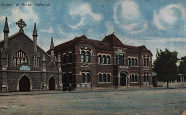
Colour postcard of the Ballarat School of Mines from Lydiard Street South. From left to right the Ballarat School of Mines Museum (Former Wesleyan Church, Administration Building, and former Ballarat Circuit Court (First building of the Ballarat School of Mines)Miss M. Foster C/o Mrs Ruffin 41 Wellington St Geelong West Dear Millie ? your pretty p.l. No. I was not vexed at your not answering my letter. I knoew you had plenty to do. Had a scrummy time at the dance. Weill keep news til later, so as my heart is on fire send me a kiss by wire love to all none to yourself because you are no good. ballarat school of mines, wesleyan church, methodist church, buildings, new classrooms, administration building, ballarat school of mines museum, former ballarat circuit court, m. foster, museum -
 Ringwood and District Historical Society
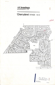
Flyer, Land Sale Advertisement - Cherrydene Estate, Stage 1 & 2, Ringwood, Vic. - 1969
Subdivison map of Cherrydene Estate and double-sided A4 size House & Land price list dated 27/10/1969. Developer - A.V. Jennings Industries (Aust) Ltd., Cnr. Springvale & Wellington Rds., Mulgrave, Vic. Phone 560 8411. Sales Dept. Rep., Leon B. Devine, Phone 560 8411 A/H.435 5311. Subdivision includes Wonga Road, Holyrood Crescent, Clipper Court, Ripley Court, Harwick Close, Bader Court, Towerhill Drive, Nigel Court, Berkley Road, Avis Court, Carmen Close, Frederic Drive, Kenwood Crescent, Adele Court, Marilyn Street, Abbey Court, Baron Court, Kismet Close, Oban Road, Ringwood.Furnished and landscaped display homes are open for your inspection, (see map on reverse side) from 11 a.m. to 5 p.m. Sundays and Holidays, and 2 p.m. to 5 p.m. weekdays and Saturdays. Display homes list for 'Cherrydene' Ringwood - Arundel, Ashmoor, Avalon, Cleveland, Chiltern, Dorset. -
 Melbourne Tram Museum
Document - List, Melbourne & Metropolitan Tramways Board (MMTB), "Salute to Australia Pageant - Australia Day 1st February 1982", "Background details of Vintage Trams in Service", Jan. 1982
List of tramcars used in the Australia Day Pageant, 1982. Prepared by the MMTB, titled "Salute to Australia Pageant - Australia Day 1st February 1982", "Background details of Vintage Trams in Service" for use on 1/2/1982. Printed on both sides of pink sheet of foolscap paper, using a wax stencil and duplicator. Gives details of MMTB 214 (V), Ballarat 27, MMTB 180 (T), Bendigo 19, MMTB 104 (L) and standby tram MMTB 164 (S). Details tram number, date built, for built for, points of interest and present operator. Also lists other vintage passenger vehicle displays in Wellington Parade, abbreviations and list of significant events concerning Melbourne tramways.trams, tramways, australia day, mmtb, melbourne, tramcars, pageant -
 Ballarat Tramway Museum
Postcard - Set of 6 and background card, Ken Flood, "Launceston Municipal Tramways"
The Postcards show trams of Launceston which operated from 1911 to 1952, published by International Railway Postcards of Launceston. The background card gives a short history of Launceston trams and the reproduction of two tickets. 1 - Postcard 1 - No. 11 leads a line up of cars in Elphin Road - Ken Flood 6-3-1948 2 - No 27, Mumford St loop - Ken Flood - 9-10-1948 3 - No. 24 Wellington St, photo Ken Flood, 26-2-1949 4 - No. 9 turns from George St into Cameron St - 25-9-1948 - Photo Ken Flood 5 - No. 26 - Talbot Road terminus - 1-11-1948 - Ken Flood 6 - No. 9 Elphin Road, 13-10-1948 - Ken Flood Yields information about Launceston trams, the Museum having No 14 on display, No. 14 from 2022.Set of 6 black and white postcards and a story card. Each have a caption on the rear and a place for a stamp and address.launceston, tramways, tramcars -
 Kew Historical Society Inc
Slide - 'Reno', St John 's Parade, 1977
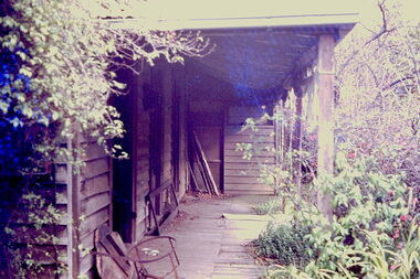
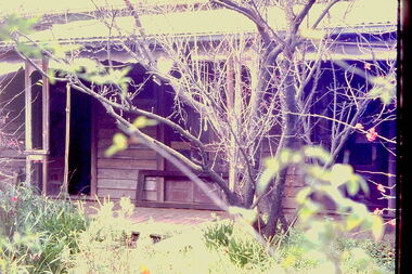
‘Reno’, stood on the east side of St John’s Parade. Its earliest recorded owner was the architect Samuel Cocking who lived there from c.1865 until his death in 1888. The original landholding was bordered by Cotham Road, Glenferrie Road, Wellington Street, and Charles Street. The southern portion of this land included a fine orchard, with many imported trees. The old summer house, at first in the orchard, was later removed to the house garden. The MMBW Detail Plan No.1576 (1904) shows the remaining portion of the original land holding, including a semi-circular pathway at the front, and garden features such as an aviary, a fountain and grotto, and a fernery. The garden including rare plants supplied by Baron Von Mueller, surrounds the cottage in a tangled frenzy. Despite a ‘local significance’ classification by the National Trust, the house was demolished in 1977.Rare photograph of an historically important weatherboard cottage in St John's Parade.Colour positive transparency (slide) of the verandah of 'Reno' in St John's Parade, Kew (demolished 1977). historic houses -- kew (vic.), reno -- st john's parade -- kew (vic.) -
 Kew Historical Society Inc
Slide - 'Reno', St John 's Parade, 1977
‘Reno’, stood on the east side of St John’s Parade. Its earliest recorded owner was the architect Samuel Cocking who lived there from c.1865 until his death in 1888. The original landholding was bordered by Cotham Road, Glenferrie Road, Wellington Street, and Charles Street. The southern portion of this land included a fine orchard, with many imported trees. The old summer house, at first in the orchard, was later removed to the house garden. The MMBW Detail Plan No.1576 (1904) shows the remaining portion of the original land holding, including a semi-circular pathway at the front, and garden features such as an aviary, a fountain and grotto, and a fernery. The garden including rare plants supplied by Baron Von Mueller, surrounds the cottage in a tangled frenzy. Despite a ‘local significance’ classification by the National Trust, the house was demolished in 1977.Rare photograph of an historically important weatherboard cottage in St John's Parade.Colour positive transparency (slide) of the a doorway of 'Reno' in St John's Parade, Kew (demolished 1977). historic houses -- kew (vic.), reno -- st john's parade -- kew (vic.) -
 Kew Historical Society Inc
Slide - 'Reno', St John 's Parade, 1977
‘Reno’, stood on the east side of St John’s Parade. Its earliest recorded owner was the architect Samuel Cocking who lived there from c.1865 until his death in 1888. The original landholding was bordered by Cotham Road, Glenferrie Road, Wellington Street, and Charles Street. The southern portion of this land included a fine orchard, with many imported trees. The old summer house, at first in the orchard, was later removed to the house garden. The MMBW Detail Plan No.1576 (1904) shows the remaining portion of the original land holding, including a semi-circular pathway at the front, and garden features such as an aviary, a fountain and grotto, and a fernery. The garden including rare plants supplied by Baron Von Mueller, surrounds the cottage in a tangled frenzy. Despite a ‘local significance’ classification by the National Trust, the house was demolished in 1977.Rare photograph of an historically important weatherboard cottage in St John's Parade.Colour positive transparency (slide) of the verandah of 'Reno' in St John's Parade, Kew (demolished 1977). historic houses -- kew (vic.), reno -- st john's parade -- kew (vic.) -
 Kew Historical Society Inc
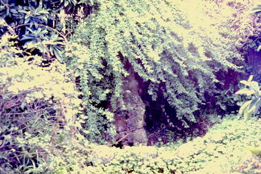
Slide - Grotto of 'Reno', St John 's Parade, 1977
‘Reno’, stood on the east side of St John’s Parade. Its earliest recorded owner was the architect Samuel Cocking who lived there from c.1865 until his death in 1888. The original landholding was bordered by Cotham Road, Glenferrie Road, Wellington Street, and Charles Street. The southern portion of this land included a fine orchard, with many imported trees. The old summer house, at first in the orchard, was later removed to the house garden. The MMBW Detail Plan No.1576 (1904) shows the remaining portion of the original land holding, including a semi-circular pathway at the front, and garden features such as an aviary, a fountain and grotto, and a fernery. The garden including rare plants supplied by Baron Von Mueller, surrounds the cottage in a tangled frenzy. Despite a ‘local significance’ classification by the National Trust, the house was demolished in 1977.Rare photograph of an historically important weatherboard cottage in St John's Parade.Colour positive transparency (slide) of the grotto in the garden of 'Reno' in St John's Parade, Kew (demolished 1977). historic houses -- kew (vic.), reno -- st john's parade -- kew (vic.) -
 Kew Historical Society Inc
Slide - Former Summerhouse in the Garden of 'Reno', St John 's Parade, 1977
‘Reno’, stood on the east side of St John’s Parade. Its earliest recorded owner was the architect Samuel Cocking who lived there from c.1865 until his death in 1888. The original landholding was bordered by Cotham Road, Glenferrie Road, Wellington Street, and Charles Street. The southern portion of this land included a fine orchard, with many imported trees. The old summer house, at first in the orchard, was later removed to the house garden. The MMBW Detail Plan No.1576 (1904) shows the remaining portion of the original land holding, including a semi-circular pathway at the front, and garden features such as an aviary, a fountain and grotto, and a fernery. The garden including rare plants supplied by Baron Von Mueller, surrounds the cottage in a tangled frenzy. Despite a ‘local significance’ classification by the National Trust, the house was demolished in 1977.Rare photograph of an historically important weatherboard cottage in St John's Parade.Colour positive transparency (slide) of the former summerhouse in the garden of 'Reno' in St John's Parade, Kew (demolished 1977). historic houses -- kew (vic.), reno -- st john's parade -- kew (vic.) -
 Kew Historical Society Inc
Slide - 'Reno', St John 's Parade, 1977
‘Reno’, stood on the east side of St John’s Parade. Its earliest recorded owner was the architect Samuel Cocking who lived there from c.1865 until his death in 1888. The original landholding was bordered by Cotham Road, Glenferrie Road, Wellington Street, and Charles Street. The southern portion of this land included a fine orchard, with many imported trees. The old summer house, at first in the orchard, was later removed to the house garden. The MMBW Detail Plan No.1576 (1904) shows the remaining portion of the original land holding, including a semi-circular pathway at the front, and garden features such as an aviary, a fountain and grotto, and a fernery. The garden including rare plants supplied by Baron Von Mueller, surrounds the cottage in a tangled frenzy. Despite a ‘local significance’ classification by the National Trust, the house was demolished in 1977.Rare photograph of an historically important weatherboard cottage in St John's Parade.Colour positive transparency (slide) of the garden of 'Reno' in St John's Parade, Kew (demolished 1977). historic houses -- kew (vic.), reno -- st john's parade -- kew (vic.) -
 Kew Historical Society Inc
Slide - Former Summerhouse in the Garden of 'Reno', St John 's Parade, 1977
‘Reno’, stood on the east side of St John’s Parade. Its earliest recorded owner was the architect Samuel Cocking who lived there from c.1865 until his death in 1888. The original landholding was bordered by Cotham Road, Glenferrie Road, Wellington Street, and Charles Street. The southern portion of this land included a fine orchard, with many imported trees. The old summer house, at first in the orchard, was later removed to the house garden. The MMBW Detail Plan No.1576 (1904) shows the remaining portion of the original land holding, including a semi-circular pathway at the front, and garden features such as an aviary, a fountain and grotto, and a fernery. The garden including rare plants supplied by Baron Von Mueller, surrounds the cottage in a tangled frenzy. Despite a ‘local significance’ classification by the National Trust, the house was demolished in 1977.Rare photograph of an historically important weatherboard cottage in St John's Parade.Colour positive transparency (slide) of the former summerhouse in the garden of 'Reno' in St John's Parade, Kew (demolished 1977). historic houses -- kew (vic.), reno -- st john's parade -- kew (vic.) -
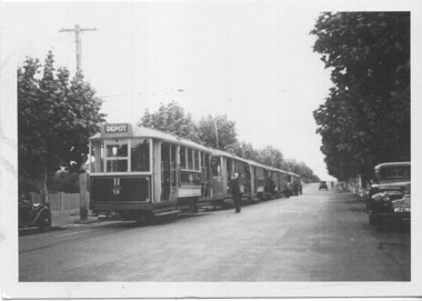
 Kew Historical Society Inc
Photograph - 'Reno', 10 St John's Parade, John T Collins, 1977
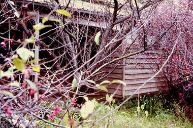
‘Reno’, stood on the east side of St John’s Parade. Its earliest recorded owner was the architect Samuel Cocking who lived there from c.1865 until his death in 1888. The original landholding was bordered by Cotham Road, Glenferrie Road, Wellington Street, and Charles Street. The southern portion of this land included a fine orchard, with many imported trees. The old summer house, at first in the orchard, was later removed to the house garden. The MMBW Detail Plan No.1576 (1904) shows the remaining portion of the original land holding, including a semi-circular pathway at the front, and garden features such as an aviary, a fountain and grotto, and a fernery. The garden including rare plants supplied by Baron Von Mueller, surrounds the cottage in a tangled frenzy. Despite a ‘local significance’ classification by the National Trust, the house was demolished in 1977.Partial view, north side of the weatherboard cottage in St John's Parade, Kew, known as 'Reno' (demolished 1977). Architectural elements revealed in this photo by John T Collins include: two wing, hip roof construction; external buildings at angles to main wing; corrugated iron roofing [over shingles]; brick chimney external to building; unvarnished/unpainted external weatherboards. General dilapidated condition. "Kew 'Reno' 10 St Johns Pde / John Collins, 11 Anderson Road, Hawthorn East, 3123, Film 35B Exposure 27"reno - st john's parade -- kew (vic.), john t collins -
 Kew Historical Society Inc
Photograph - 'Reno', 10 St John's Parade, John T Collins, 1977
‘Reno’, stood on the east side of St John’s Parade. Its earliest recorded owner was the architect Samuel Cocking who lived there from c.1865 until his death in 1888. The original landholding was bordered by Cotham Road, Glenferrie Road, Wellington Street, and Charles Street. The southern portion of this land included a fine orchard, with many imported trees. The old summer house, at first in the orchard, was later removed to the house garden. The MMBW Detail Plan No.1576 (1904) shows the remaining portion of the original land holding, including a semi-circular pathway at the front, and garden features such as an aviary, a fountain and grotto, and a fernery. The garden including rare plants supplied by Baron Von Mueller, surrounds the cottage in a tangled frenzy. Despite a ‘local significance’ classification by the National Trust, the house was demolished in 1977.Partial view, side of the weatherboard cottage in St John's Parade, Kew, known as 'Reno' (demolished 1977). Architectural elements revealed in this photo by John T Collins include: hip roof construction; corrugated iron roofing [over shingles]; unvarnished/unpainted external weatherboards; Externally opening 1860s-style casement window. General dilapidated condition. "Kew 'Reno' 10 St Johns Pde / John Collins, 11 Anderson Road, Hawthorn East, 3123, Film 35B Exposure 26"reno - st john's parade -- kew (vic.), john t collins -
 Kew Historical Society Inc
Photograph - 'Reno', 10 St John's Parade, John T Collins, 1977
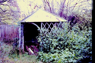
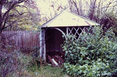
‘Reno’, stood on the east side of St John’s Parade. Its earliest recorded owner was the architect Samuel Cocking who lived there from c.1865 until his death in 1888. The original landholding was bordered by Cotham Road, Glenferrie Road, Wellington Street, and Charles Street. The southern portion of this land included a fine orchard, with many imported trees. The old summer house, at first in the orchard, was later removed to the house garden. The MMBW Detail Plan No.1576 (1904) shows the remaining portion of the original land holding, including a semi-circular pathway at the front, and garden features such as an aviary, a fountain and grotto, and a fernery. The garden including rare plants supplied by Baron Von Mueller, surrounds the cottage in a tangled frenzy. Despite a ‘local significance’ classification by the National Trust, the house was demolished in 1977.Side of the original, relocated summer house of 'Reno' at 10 St John's Parade, Kew, (demolished 1977). Architectural elements revealed in this photo by John T Collins include: four-sided construction; trellis and weatherboard walls; corrugated iron roofing. Re-use as woodshed. General dilapidated condition. "Kew 'Reno' 10 St Johns Pde / John Collins, 11 Anderson Road, Hawthorn East, 3123, Film 35B Exposure 24"reno - st john's parade -- kew (vic.), john t collins -
Tarnagulla History Archive
Smith Letters
John Smith was a carpenter and/or timber merchant who emigrated from England to Australia. He settled in Launceston in 1834-6. In 1836 he married Susannah (of Birmingham, nee Bradney/Bradbury, daughter of a gunsmith). Their first child was born in Launceston in 1837 (records in Wesleyan Church). They set out to try the Californian goldfields but at Tahiti they received such bad news about the Californian goldfields that they changed their minds and returned to Port Phillip. Apparently, John Smith's nephew George died of T.B. less than a year after arriving at Tarnagulla. John Smith, Susannah and two of their 9+ children are buried in St Kilda Cemetery (Wesleyan sector). They were lifelong members of the Wesleyan Church. A John Smith, carpenter was listed as being a business in Wellington St, St Kilda 1856-1860. Donald Clark Collection.Eleven photocopied pages. Four pages are a letter (date circa 1990s) from S.A.S. Smith of England to Lorna Goltz of the Tarnagulla Gold n Rocks Museum. It explains the context of some accompanying photocopied historical letters. All the letters relate to S.A.S. Smith's ancestors who lived in Tarnagulla for a time. The photocopies are of: 1) Letter dated 15th April 1857, written and sent from St Kilda by John Smith 2) Letter dated October 24th, 1866, written and sent from Tarnagulla by John Smith 3) Letter dated October 17, 1866 written and sent from Tarnagulla by George, nephew of John Smith. -
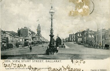 Ballarat Tramway Museum
Postcard, Victoria Stamp Market and Melbourne, Gen. View Sturt Street, Ballarat
Printed black and white postcard of the Sturt St looking west from Grenville St. Has the large gas lamp in the centre of the intersection with Grenville St. Card had a stamp on the photo side, but has been removed - only the remnants of the gum and postmark remain. No horse tram lines visible. Photo assumed to be pre 1887. Written on the front "Best Wishes from Dorrie ?" and date "8/4/06". Printed along the lower edge "Published by Victoria Stamp Market, Melbourne" and "Printed in Germany". On rear is places for stamp, address only. Addressed to Mss L Schwarz, Waiwhitu Road, Lower Hutt, Wellington New Zealand. Written on the stamp position is "The ........ on other side". Titled "Gen. View Sturt Street, Ballarat." along bottom edge of the photo. trams, tramways, sturt st, postcards, grenville st -
Kew Historical Society Inc
Archive (series) - Subject File, Kew Bowling Club (Vic), 1980
Various partiesReference, Research, InformationSecondary valuesSubject file on the former Kew Bowling Club (Vic), founded in 1880 and amalgamated with the Auburn Heights Bowling Club in 1998. The Club was located behind the Kew Recreation Hall at 12-16 Wellington Street, Kew. The file contains both primary and secondary sources. Primary sources include twelve annual reports (1984-85 to 1988-89; 1990-1 to 1996-97); sundry copies of the Club’s newsletter - ‘Kew View’ from the period 1980-95; magazines celebrating the inaugural and second annual ‘Kew Cup’ (1992-93); ephemera such as the programs for the Centenary Dinner (1980); the Club’s Constitution (1987); and research notes and newspaper articles/clippings. The file also includes two copies of the Club’s history. A number of documents relate to the proposed sale of the land by Boroondara Council in 2001. In 2020, KHS accepted into its collection the entire collection and archives of the Kew Bowling Club. These are stored separately.kew - history, sports - lawn bowls - kew (vic), kew bowling club - wellington street - kew (vic)kew - history, sports - lawn bowls - kew (vic), kew bowling club - wellington street - kew (vic) -
 Melbourne Tram Museum
Photograph - Set of 15 Colour Print/s, Bill Davis, mid 1980's to 1990
Set of 15 colour prints of a tram tours in Melbourne, featuring W5 tramcars, 685 (converted) and 782 (unconverted) mid 1980's to 1990. Photos not well focused. .1 - At Albert Park beach terminus, Mills St. .2 - ditto .3 - ditto .4 - Peel St North Melbourne .5 - ditto .6 - ditto .7 - Ascot Vale Road, Showgrounds loop .8 - ditto .9 - Albert St, South Melbourne Beach Loop .10 - ditto .11 - Fletcher St Essendon. .12 - Fletcher St Essendon .13 - Wellington Parade shunt .14 - ditto .15 - ditto Features advertisements on trams for: Spring Valley drinks, Bank of Melbourne, Fox Radio, UDL drinks, All printed on Kodak paper.trams, tramways, mmtb, tours, albert park, showgrounds, wellington parade, peel st, tram 685, tram 782 -
 Melbourne Tram Museum
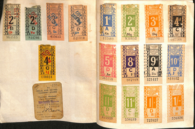
Ephemera - Exercise Book, The Reading Universal, "Tickets", 1950's to 1980's
Exercise or Mapping book - The Reding Universal Mapping book, blue front cover plain paper, holding tickets collected by Keith Stodden. Titled "Tickets". Tickets have been positioned using stamp hinges. Pages 1 to 13 - MMTB imperial, dual and decimal currency tram and bus tickers, including a Munitions workers fare concession certificate, Scholars Concession ticket, swimming, Adelaide. 14 - 15 - SEC and Brisbane tickets 16 - 17 - MTT Adelaide 18 - 24 - MMTB mixed and some railway card 25 - 26 - Sydney 26 - 28 - Hobart 29 - 30 - Mixed - MOTAT, Ferrymead, Brisbane, Hornibrook Highway Toll, 31 - 32- Melbourne Rail, mixed admission, VR Excess Fare 33 - 34 - SEC 35 - 36 - Dunedin 37 - 38 - Christchurch 39 - 41 - Wellington 42 - Auckland 43 - NZR rail 44 - MMTB 45 - 46 - MTT Adelaide, Tallahassee, St Claude 47 - 48 - Ballarat, Bendigo and TMSV 49 - MMTB 50 - TMSV, SPER 51 - Brisbane 52 - Parramatta Park (COTMA), Eurail pass 53 - Hong Kong, Melbourne rail, platform tickets, pram tickets, Begonia Festival car park, 54 - 55- Mixed - NZR, Wellington, 56 - Auckland 57 - 58 - AETM, Adelaide, 59 - 60 Adelaide, MMTB, Exhibition buildings car park, 61 - Radio receiving licence, mixed bus tricks, Ansett, TAA, 62 - cover - mixed - Ansett, TAA, Ballarat ESCo, Melbourne transport Pageant and MTA/The Mettrams, tramways, tickets, the met, mmtb, adelaide, sec, tmsv, sydney, buses -
Kew Historical Society Inc
Archive (sub-series) - Printed Civic Ephemera, Town of Kew et al, 1913-1981
Town Clerk's Office, City of KewPrinted cardsDate orderItems relating to civic events, typically held by mayors of the City of Kew, or invitations from other cities to Council officers or councillors. h h harrison -- town clerk -- borough of kew -- town of kew -- city of kew, w d birrell -- town clerk -- city of kew, civic ephemera - city of kewh h harrison -- town clerk -- borough of kew -- town of kew -- city of kew, w d birrell -- town clerk -- city of kew, civic ephemera - city of kew -
 Mentone Grammar School
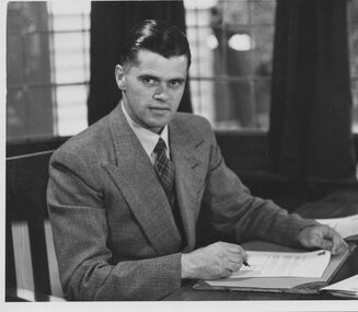
Principal (1939-1960) John Jeffrey Thorold
In October 1939, on the sudden death of his father, Headmaster Charles C Thorold, son, John Jeffery (J.J.) Thorold, a 26-year-old accountant and sole beneficiary and executor was suddenly responsible for 42 students. Numbers had dwindled during the Depression and the situation was so dire, J.J. put the School up for sale. Fortunes changed when the parent of a boarder offered financial support and together with the skeptical backing of Francis Wellington Were, father of J.J.'s step mother, Jessie, the School numbers grew during the war from 50 to 280. The majority of the newcomers were boarders and evacuees from northern Australia as well as England. J.J. adopted the title Principal and worked tirelessly to build the school. He briefly appointed Arthur Burnaby as Headmaster before his search for a permanent Head resulted with the appointment of Lionel Ashley Large in 1945. -
 Ballarat Tramway Museum
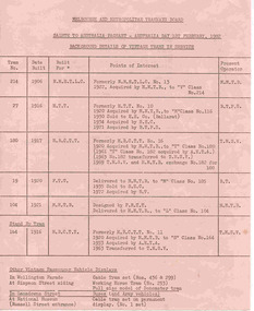
Document - List, Melbourne and Metropolitan Tramways Board (MMTB), "Salute to Australia Pageant - Australia Day 1st February 1982", Jan. 1982
List of tramcars used in the Australia Day Pageant, 1982. Prepared by the MMTB, titled "Salute to Australia Pageant - Australia Day 1st February 1982", "Background details of Vintage Trams in Service" for use on 1/2/1982. Printed on both sides of pink sheet of foolscap paper, using a wax stencil and duplicator. Gives details of MMTB 214 (V), Ballarat 27, MMTB 180 (T), Bendigo 19, MMTB 104 (L) and standby tram MMTB 164 (S). Details tram number, date built, for built for, points of interest and present operator. Also lists other vintage passenger vehicle displays in Wellington Parade, abbreviations and list of significant events concerning Melbourne tramways. 2nd copy added 22/08/04 - has had bottom section of sheet torn off. Images of this item shown.australia day, mmtb, melbourne, tramcars, pageant -
 Kew Historical Society Inc
Photograph, J F C Farquhar, Bird's Eye View Looking West, 1891
At the beginning of the 1890s, the Kew businessman and Town Councillor, Henry Kellett, commissioned J.F.C. Farquhar to photograph scenes of Kew. These scenes included panoramas as well as pastoral scenes. The resulting set of twelve photographs was assembled in an album, Kew Where We Live, from which customers could select images for purchase.The preamble to the album describes that the photographs used the ‘argentic bromide’ process, now more commonly known as the gelatine silver process. This form of dry plate photography allowed for the negatives to be kept for weeks before processing, hence its value in landscape photography. The resulting images were considered to be finely grained and everlasting. Evidence of the success of Henry Kellett’s venture can be seen today, in that some of the photographs are held in national collections.It is believed that the Kew Historical Society’s copy of the Kellett album is unique and that the photographs in the book were the first copies taken from the original plates. It is the first and most important series of images produced about Kew. The individual images have proved essential in identifying buildings and places of heritage value in the district.Before true aerial photography became possible, photographers such as J.F.C. Farquhar were compelled to shoot their images from the highest vantage point. Here, it is presumed to be the roof of Xavier College, from which the panoramic view extends west towards the rise of Studley Park. The houses in the foreground face the southern end of Gellibrand Street. Wellington Street is at an angle to the camera with the Queen Street intersection on the near right. The wooden building behind the large horse paddock on the other side of Gellibrand Street is the Kew Recreation Hall, built 1888, demolished 1960. It was reputed to have one of the finest dancing floors in or around Melbourne. The Bowling Green at the rear of the Hall belonged to the Kew Bowling Club. Further west is the Kew Railway Station on Denmark Street, opened to the public in 1887. At this period, much of Studley Park was locked up in large landholdings, dominated by large mansions such as ‘Byram’. Bird's Eye View Looking Westkew illustrated, kew where we live, photographic books, henry kellett, denmark street, kew recreation hall, kew bowling club, wellington street -
 Kew Historical Society Inc
Photograph, J F C Farquhar, Studley Park Road, 1891
At the beginning of the 1890s, the Kew businessman and Town Councillor, Henry Kellett, commissioned J.F.C. Farquhar to photograph scenes of Kew. These scenes included panoramas as well as pastoral scenes. The resulting set of twelve photographs was assembled in an album, Kew Where We Live, from which customers could select images for purchase.The preamble to the album describes that the photographs used the ‘argentic bromide’ process, now more commonly known as the gelatine silver process. This form of dry plate photography allowed for the negatives to be kept for weeks before processing, hence its value in landscape photography. The resulting images were considered to be finely grained and everlasting. Evidence of the success of Henry Kellett’s venture can be seen today, in that some of the photographs are held in national collections.It is believed that the Kew Historical Society’s copy of the Kellett album is unique and that the photographs in the book were the first copies taken from the original plates. It is the first and most important series of images produced about Kew. The individual images have proved essential in identifying buildings and places of heritage value in the district.In this view of Studley Park Road, looking northeast to the Junction, the photographer invites the viewer to participate in a point-of-view that emphasises the elevated, tranquil vantage point of the hill in contrast to the bustling commercial area in the distance. The view emphasises the exclusiveness of Studley Park, with its high fences behind which a number of significant Kew mansions were concealed. Contemporary advertisements for the sale of mansions in Studley Park Road often included fulsome descriptions of their elaborate formal gardens, as well as paddocks for grazing, stabling and dairies. None can be seen here. The use of high, protective wooden pickets to surround the newly planted avenue of elms on the south side of the road appears to be typical of the period. Similar examples can be seen in early photographs of Wellington and Princess Streets.The horse and carriage, selected as a central focus of the view, reinforces the residential, exclusive nature of this part of Kew in the early 1890s. Studley Park Roadkew illustrated, kew where we live, photographic books, henry kellett -
 Kew Historical Society Inc
Plan - Subdivision Plan, J R Mathers & McMillan, Glenarbor Estate, 1934
Pru Sanderson, in her groundbreaking ‘City of Kew Urban Conservation Study : Volume 2 - Development History’ (1988), summarised the periods of urban development and subdivisions of land in Kew. The periods that she identified included 1845-1880, 1880-1893, 1893-1921, 1921-1933, 1933-1943, and Post-War Development. These periods were selected as they represented periods of rapid growth or decline in urban development. An obvious starting point for Sanderson’s groupings involved population growth and the associated economic cycles. These cycles also highlighted urban expansion onto land that was predominantly rural, although in other cases it represented the decline and breakup of large estates. A number of the plans in the Kew Historical Society’s collection can also be found in other collections, such as those of the State Library of Victoria and the Boroondara Library Service. A number are however unique to the collection.The Kew Historical Society collection includes almost 100 subdivision plans pertaining to suburbs of the City of Melbourne. Most of these are of Kew, Kew East or Studley Park, although a smaller number are plans of Camberwell, Deepdene, Balwyn and Hawthorn. It is believed that the majority of the plans were gifted to the Society by persons connected with the real estate firm - J. R. Mathers and McMillan, 136 Cotham Road, Kew. The Plans in the collection are rarely in pristine form, being working plans on which the agent would write notes and record lots sold and the prices of these. The subdivision plans are historically significant examples of the growth of urban Melbourne from the beginning of the 20th Century up until the 1980s. A number of the plans are double-sided and often include a photograph on the reverse. A number of the latter are by noted photographers such as J.E. Barnes.The little-known Glenarbor Estate comprised 23 allotments bordering Wellington and Denmark Streets and Fenton Avenue. The auction of the allotments in the Estate was held in the Kew Recreation Hall. The purported advantages to Kew are identified on the plan, such as the close proximity of the entrance to the Kew Railway Station and access to shops in Denmark Street. Due to its location, the subdivision was pitched at commercial as well as residential purchasers. The Estate was to cause a crisis in the Kew Council as a majority of councillors voted on 29 May to acquire the entire Estate as the location of a new Town Hall. The Estate was said to be valued at £50,000. A later meeting was to rescind the vote, instead opting for the compulsory acquisition of South Esk on the corner of Charles Street and Cotham Road. That acquisition was to be overturned by the State Government. The debate about the purchase of the Glenarbor Estate by Council coincided with the decision to widen High Street on the South side between Cotham Road and the Junction."D"subdivision plans - kew, glenarbor estate, wellington street, denmark street -
 Kew Historical Society Inc
Plan, Melbourne & Metropolitan Board of Works : Borough of Kew : Detail Plan No.1575, 1905
The Melbourne and Metropolitan Board of Works (MMBW) plans were produced from the 1890s to the 1950s. They were crucial to the design and development of Melbourne's sewerage and drainage system. The plans, at a scale of 40 feet to 1 inch (1:480), provide a detailed historical record of Melbourne streetscapes and environmental features. Each plan covers one or two street blocks (roughly six streets), showing details of buildings, including garden layouts and ownership boundaries, and features such as laneways, drains, bridges, parks, municipal boundaries and other prominent landmarks as they existed at the time each plan was produced. (Source: State Library of Victoria)This plan forms part of a large group of MMBW plans and maps that was donated to the Society by the Mr Poulter, City Engineer of the City of Kew in 1989. Within this collection, thirty-five hand-coloured plans, backed with linen, are of statewide significance as they include annotations that provide details of construction materials used in buildings in the first decade of the 20th century as well as additional information about land ownership and usage. The copies in the Public Record Office Victoria and the State Library of Victoria are monochrome versions which do not denote building materials so that the maps in this collection are invaluable and unique tools for researchers and heritage consultants. A number of the plans are not held in the collection of the State Library of Victoria so they have the additional attribute of rarity.Original survey plan, issued by the MMBW to a contractor with responsibility for constructing sewers in the area identified on the plan within the Borough of Kew. The plan was at some stage hand-coloured, possibly by the contractor, but more likely by officers working in the Engineering Department of the Borough and later Town, then City of Kew. The hand-coloured sections of buildings on the plan were used to denote masonry or brick constructions (pink), weatherboard constructions (yellow), and public buildings (grey). Plan No.1575 shows that in the area bounded by Wellington Street, Edgevale Road, Glenferrie Road, and Cotham Road, there had already been significant subdivision of land and houses constructed. As one of the highest points in Kew, as expected, there were already some significant mansions built on large allotments of land. Many of these mansions are identified by name on the plan such as ‘Kelso’, ‘Abbotsford’, ‘Clarendon’ and ‘Ashlyn’ in Cotham Road. Other houses of equal size are unnamed on the plan.melbourne and metropolitan board of works, detail plans, maps - borough of kew, mmbw 1575, cartography