Showing 31258 items
matching buildings
-
 Ballarat Tramway Museum
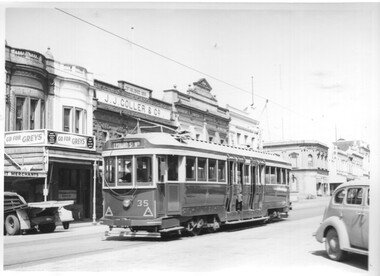
Photograph - Black & White Photograph/s, Charles Craig, 1950's
Yields information about the use of the appearance of tram 35 and Lydiard St North between Mair St and the railway station during the late 1950's.Black and white photograph of Ballarat tram 35, northbound in Lydiard St North with the J J Coller & Co building, Herbert E Smith Merchant in the background. Advert for Greys cigarettes in the view. The buildings on the corner of Mair St are in the view as well. Photo by Charles Craig possibly late 1950's. trams, tramways, lydiard st north, mair st, tram 35 -
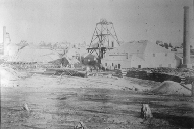
 Bendigo Historical Society Inc.
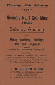
Document - IAN DYETT COLLECTION: AUCTION CATALOGUE - HERCULES NO. 1 GOLD MINE
Brown covered auction catalogue for a sale held on 12th February (no year) at the Hercules No. 1 Gold Mine of Mining Machinery,Buildings, Plant and Equipment by Order Hercules No. 1 Gold Mining Company N. L. Contains descriptions of various machinery and buildings. J. H. Curnow & Son were the auctioneers.business, auctioneers, j h curnow & son pty ltd, ian dyett collection - auction catalogue - hercules no. 1 gold mine, j h curnow & son, j l jamieson & co, the cambridge press -
 Bendigo Historical Society Inc.
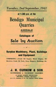
Document - IAN DYETT COLLECTION: AUCTION CATALOGUE - BENDIGO MUNICIPAL QUARRIES - AXEDALE
Three auction catalogues of a sale at the Bendigo Municipal Quarries, Axedale on 2nd September, 1941 of Surplus Machinery, Plant, Buildings and Equipment comprising Crude Oil Engine, Diesel Engine, air Receiver, Crude Oil Tank, Stone Hoppers Buildings, etc. J. H. Curnow & Son were the auctioneers.business, auctioneers, j h curnow & son pty ltd, ian dyett collection - auction catalogue - bendigo municipal quarries - axedale, j h curnow & son, j l jamieson & co, the cambridge press -
 Ballarat Tramway Museum
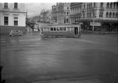
Negative, Wal Jack, late 1940's or early 1950's
Yields information about the Sturt and Lydiard St intersection and tram services.Negative and Digital image of the Wal Jack Ballarat Negative file of No. 21 turning from Sturt St south side into Lydiard St North. Has the Commonwealth Bank building, National Mutual, and Craig's Hotel. The small newsagent kiosk is in the photo. C. Marks Jewellers in the National Mutual building sign. trams, tramways, sturt st, lydiard st north, tram 23 -
 Kiewa Valley Historical Society
Photograph - Folder of Photographs – Photocopied set of black and white photographs (pages 9 - 18) from the display folder put together by KVHS to document life on the Kiewa Valley Hydro-electric Scheme
Although the Kiewa Hydro-Electric Scheme was first proposed in 1911, construction did not commence until 1938. As part of the push to cut electricity costs and diversify supply, the Victorian Government (circa 1930) initiated the conversion from primarily brown coal supply to hydro – electricity. Field investigations during the 1940’s resulted in a new proposal for a scheme that had more than double the capacity of the 1938 scheme. The Kiewa Hydroelectric Scheme became the largest scheme of its kind in the State Of Victoria and the second largest scheme in Australia. The number of personnel involved in the planning and construction of the scheme increased dramatically. During the late 1940’s, most activity centred around the construction of the West Kiewa Power Station, Rocky Valley Reservoir, McKay Creek Power Station and the Bogong Creek Aqueduct.A common thread across all the larger hydro scheme constructions was the need for workers, both qualified and unqualified who came from around the world seeking a new life for themselves and their families. New accommodation and facilities were required for the army of workers engaged in construction in often remote and wild areas. The SEC had a high demand for timber, and set up the first of a number of sawmills at Bogong Creek in 1939 and set up the first hardwood logging in the headwaters of the Kiewa River. These new ‘towns’ such as Mt Beauty and Bogong, survived, serving the needs of operational personnel and their families, and expanding with growth of new industries. Mount Beauty, and to a lesser extent Bogong, are among these places. PHYSICAL: Large A3 size spiral bound display folder containing 21 pages of photocopied black and white photographs of various aspects of the early days of the Kiewa Valley Hydro-electric scheme including equipment, various work sites and photographs of workers and their families. 1-Bridge across Tailrace Channel 1946 2-New Mess building, Mt Beauty 3-Homan’s Gap Saw Mill 4- Diamond Drilling Plant – Big Hill 5-Rocky Valley Camp-Mess Building 6-Parlimentary Party at Rocky Valley 7-No.4 Headrace Tunnel 8- Allis-Chalmers Tractor School 9- SECV Heavy Machinery lined up by road 10- No. 5 Raceline – Balasting Track with improvised truck 1-1946 – Bridge across tailrace channel Page number 9 2-New mess building, Mt Beauty 6.4.46 Page number 10 3- STATE ELECTRICITY COMMISSION OF VICTORIA Date: 10.1.47 Time: 11.40am No K2271 Kiewa Hydro Electric Works Homan’s Gap Saw Mill – Rip Saw Page number 11 4- STATE ELECTRICITY COMMISSION OF VICTORIA Date: 5.10.47 Time: 11am No K4111 Kiewa Hydro Electric Works Diamond Drilling Plant – Big Hill Page number 12 5- STATE ELECTRICITY COMMISSION OF VICTORIA Date: 11.2.48 Time: 3pm No K4277 Kiewa Hydro Electric Works Rocky Valley Camp-Mess Building Page number 13 6- STATE ELECTRICITY COMMISSION OF VICTORIA Date: 15.4.48 Time: 4.30pm No K4397 Kiewa Hydro Electric Works Parlimentary Party at Rocky Valley Page number 14 7- STATE ELECTRICITY COMMISSION OF VICTORIA Date: 22.8.48 Time: 9am No K4668 Kiewa Hydro Electric Works General view of No.4 Headrace Tunnel Page number 15 8-STATE ELECTRICITY COMMISSION OF VICTORIA Date: 5.9.49 Time: 10am No K5180 Kiewa Hydro Electric Works Allis-Chalmers Tractor School – HD 19, Mr I Crossthwaite at Controls Page number 16 9- No markings Page number 17 10- STATE ELECTRICITY COMMISSION OF VICTORIA Date: 7,12.49 Time: 4pm No K5423 Kiewa Hydro Electric Works No. 5 Raceline – Balasting Track with improvised truck. Page number 18 secv; kiewa hydro electric scheme; mt beauty; bogong; construction area -
 St Kilda Historical Society
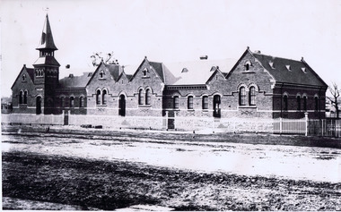
Photograph, St Kilda Primary School, (BrIghton Road) 1882, c. 1882
St Kilda Primary School, (BrIghton Road) 1882, additional notes: built in 1875 On the back: Copy courtesy LaTrobe Library, Melbourne From: Archives Victoria Photographs of State School Buildings. Vol 1. State School, St Kilda (Brighton Road) Hand written: School built 1975. Tower was not moved until some time after 1882. Accompanied by a smaller copy of the same photograph.black and white photograph fair condition unmountedSt Kilda Primary School, (BrIghton Road) 1882, additional notes: built in 1875 On the back: Copy courtesy LaTrobe Library, Melbourne From: Archives Victoria Photographs of State School Buildings. Vol 1. State School, Paterson Bros. Photos. Melbourne. St Kilda (Brighton Road) 1882. School built 1975. Tower was not moved until some time after 1882. D.J Taggart 58 Glenhuntly road, Elwood 3184. St Kilda Historical Collection, 150 Carlisle street, St Kilda. -
 Wodonga & District Historical Society Inc
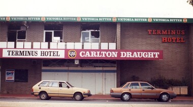
Photograph - Terminus Hotel Wodonga Fire 1998, C. 1998
The Terminus Hotel, Wodonga was built by James Thompson Hatch in 1873, the same year the railway reached Wodonga from Melbourne. It was named due to its close proximity to the railway terminus. It was sold to Messrs George Day and Kenneth McLennan of Albury. It was first licenced to J.G. Morton in January 1874. Annie Allen, from Ireland, took over as licensee of the hotel containing 14 rooms in 1879, after she and her husband, George James Allen, purchased it. In 1887 they added a new wing on the south boundary of the property next to Peter McLean’s store at 81 Sydney Road. The architects for the new wing were Gordon and Gordon. A billiard room, a dining room, and 18 other rooms were added on the vacant block of land between the Hotel and the Bank of Victoria. A balcony 6 feet wide was added on the north side. Included in the plans was the latest patent elevator, later known as a dumb waiter. Allen died in 1889 aged 52, and Annie Allen continued to run the Terminus. She later married John G. Haldon and was licensee of the hotel until December 1898 when the licence was transferred to William Carkeek. Carkeek, from Cornwall, arrived in the colony around 1860 and is considered one of the founders of Tallangatta. In November 1903, the license was transferred to Daniel Crawford, then in 1906 it was transferred to Mr Stephen Carkeek. In 1916 it passed into the hands of Mr H. W. Allen of Rutherglen, son of Mr George James Allen. On 1st June 1998 the Terminus Hotel was destroyed by fire. Estimates of damage range from between a conservative $750,000 to as high as $2 million. The remains of the building were demolished in 1999.The Terminus Hotel was one of the earliest hotels in Wodonga with clear links to the establishment of the railway line. It was an important business and meeting place for social gatherings. On 1st June 1998 the Terminus Hotel was destroyed by fire. Estimates of damage range from between a conservative $750,000 to as high as $2 million. The remains of the building were demolished in 1999. These images capture the extent of damage prior to the demolition. -
 Kew Historical Society Inc
Plan, Melbourne & Metropolitan Board of Works : Borough of Kew : Detail Plan No.1571, 1904
The Melbourne and Metropolitan Board of Works (MMBW) plans were produced from the 1890s to the 1950s. They were crucial to the design and development of Melbourne's sewerage and drainage system. The plans, at a scale of 40 feet to 1 inch (1:480), provide a detailed historical record of Melbourne streetscapes and environmental features. Each plan covers one or two street blocks (roughly six streets), showing details of buildings, including garden layouts and ownership boundaries, and features such as laneways, drains, bridges, parks, municipal boundaries and other prominent landmarks as they existed at the time each plan was produced. (Source: State Library of Victoria)This plan forms part of a large group of MMBW plans and maps that was donated to the Society by the Mr Poulter, City Engineer of the City of Kew in 1989. Within this collection, thirty-five hand-coloured plans, backed with linen, are of statewide significance as they include annotations that provide details of construction materials used in buildings in the first decade of the 20th century as well as additional information about land ownership and usage. The copies in the Public Record Office Victoria and the State Library of Victoria are monochrome versions which do not denote building materials so that the maps in this collection are invaluable and unique tools for researchers and heritage consultants. A number of the plans are not held in the collection of the State Library of Victoria so they have the additional attribute of rarity.Original survey plan, issued by the MMBW to a contractor with responsibility for constructing sewers in the area identified on the plan within the Borough of Kew. The plan was at some stage hand-coloured, possibly by the contractor, but more likely by officers working in the Engineering Department of the Borough and later Town, then City of Kew. The hand-coloured sections of buildings on the plan were used to denote masonry or brick constructions (pink), weatherboard constructions (yellow), and public buildings (grey). This plan is the other half of Plan No.1571 representing the constructions to the west of Wellington Street before and in 1903/4. This plan represents the built environment in Edgevale Road, Wellington Street, Atkins Street, Annadale Street, Mortimer Street, and Cotham Road. Whereas there are smaller allotments and more modest housing stock facing Edgevale Road, larger blocks and more substantial houses are represented facing Cotham Road.melbourne and metropolitan board of works, detail plans, mmbw 1571, cartography -
 Kew Historical Society Inc
Plan, Melbourne & Metropolitan Board of Works : Borough of Kew : Detail Plan No.1575, 1905
The Melbourne and Metropolitan Board of Works (MMBW) plans were produced from the 1890s to the 1950s. They were crucial to the design and development of Melbourne's sewerage and drainage system. The plans, at a scale of 40 feet to 1 inch (1:480), provide a detailed historical record of Melbourne streetscapes and environmental features. Each plan covers one or two street blocks (roughly six streets), showing details of buildings, including garden layouts and ownership boundaries, and features such as laneways, drains, bridges, parks, municipal boundaries and other prominent landmarks as they existed at the time each plan was produced. (Source: State Library of Victoria)This plan forms part of a large group of MMBW plans and maps that was donated to the Society by the Mr Poulter, City Engineer of the City of Kew in 1989. Within this collection, thirty-five hand-coloured plans, backed with linen, are of statewide significance as they include annotations that provide details of construction materials used in buildings in the first decade of the 20th century as well as additional information about land ownership and usage. The copies in the Public Record Office Victoria and the State Library of Victoria are monochrome versions which do not denote building materials so that the maps in this collection are invaluable and unique tools for researchers and heritage consultants. A number of the plans are not held in the collection of the State Library of Victoria so they have the additional attribute of rarity.Original survey plan, issued by the MMBW to a contractor with responsibility for constructing sewers in the area identified on the plan within the Borough of Kew. The plan was at some stage hand-coloured, possibly by the contractor, but more likely by officers working in the Engineering Department of the Borough and later Town, then City of Kew. The hand-coloured sections of buildings on the plan were used to denote masonry or brick constructions (pink), weatherboard constructions (yellow), and public buildings (grey). Plan No.1575 shows that in the area bounded by Wellington Street, Edgevale Road, Glenferrie Road, and Cotham Road, there had already been significant subdivision of land and houses constructed. As one of the highest points in Kew, as expected, there were already some significant mansions built on large allotments of land. Many of these mansions are identified by name on the plan such as ‘Kelso’, ‘Abbotsford’, ‘Clarendon’ and ‘Ashlyn’ in Cotham Road. Other houses of equal size are unnamed on the plan.melbourne and metropolitan board of works, detail plans, maps - borough of kew, mmbw 1575, cartography -
 Phillip Island and District Historical Society Inc.
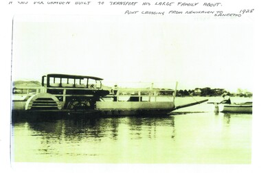
Photograph, Newhaven punt and Nobbies tea house, 1928, 1929
Historical4 A4 photocopies of black & white photos. A large bus on a punt with a person onboard. A small boat with 2 men towing the punt. Land in the background. Wooden building with a group of 6 people standing outside, one looking through telescope.with sloping roof and sign Ye Olde Tea House. Set on barren headland, sea in background with 2 small outbuildngs and a car parked beside building. Other photos show group of cars parked near the same building or on barren headland.A bus Dick Grayden built to transport his large family about 1928. Punt crossing from Newhaven to San Remo. Original tea house at Nobbies. 1929phillip island punt, richard grayden, the nobbies kiosk, point grant, motor car -
 Glenelg Shire Council Cultural Collection
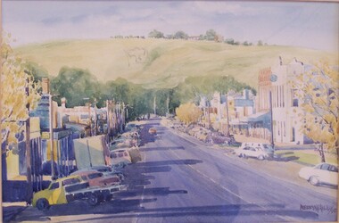
Painting - Painting (Henty Street Casterton), Untitled, 1995
The watercolour painting depicts a street scene with a grass hill in the background. The street forms the centre of the foreground and features a row of buildings and cars on both sides of the street. Long shadows extend from the buildings and trees with yellow leaves frame both edges of the work. Across the middle of the work green trees are used to separate the street from the hill in the background. The large grass hill features an outlined shape (Scout symbol) on the side and a building surrounded by trees on top. The work is mounted and framed in a brown and gold frame with glass.Front: Mervyn Hill/95 Back: Framing by W.D. & C.M. Davis RMB 1256 Casterton 3311 Phone (055) 75 3290 -
 Federation University Historical Collection
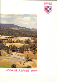
Book, Ballarat University College Annual Report, 1989
The President of Ballarat University College in 1989 was E.T. Oppy.Soft covered book with an aerial photograph of the Mount Helen campus and Mt Buninyong on the cover. The annual report includes a background of the establishment and governance of Ballarat University College, Remote Sensing Laboratory, Naming of E.J. Barker Library, Computer Centre, Financial Statement The report outlines the completion of the following buildings: * Mt Helen Adminsitration Building * Mt Helen Creche *Physical education Office Extension * Geology Annex the following buildings were commenced: * Staff/Student extension * Librarianship/Business Offices 8 Art extensionballarat university college, oppy, barker, e.j. barker library -
 Port Melbourne Historical & Preservation Society
Booklet - Amenities Block, J Kitchen & Sons, Unilever Australia Pty Ltd, 1957
Nineteen page booklet with pale blue card cover (with drawing of Amenities Block) and brighter blue binding. The introduction states that the building is about to be completed and it is for all employees use. Written in 1957 it includes section headings - Progress of amenities, Port Melbourne; Design of the building ; Dining and canteen facilities ; Locker and toilet facilities ; Medical centre ; Entrance and time clocks ; Personnel Department ; Social Club library ; Conference room ; Vehicles; Changes in the use ofbuildings ; Use of the building; and drawing of the layout of each floor.industry - manufacturing, business and traders - soaps/candles, built environment - industrial, workers, unilever australia (holdings) ltd, j kitchen & sons pty ltd -
 Bendigo Historical Society Inc.
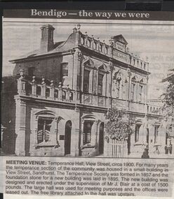
Newspaper - JENNY FOLEY COLLECTION: MEETING VENUE
Bendigo Advertiser "The way we were" from 1999. Meeting venue: Temperance hall, View Street, circa 1900. For many years the temperance section of the community was housed in a small building in View Street, Sandhurst. The Temperance Society was formed in 1857 and the foundation stone for a new building was laid in 1895. The new building was designed and erected under the supervision of Mr. J. Blair at a cost of 1,500 pounds. The large hall was used for meeting purposes and the offices were leased out. The free library attached to the hall was upstairs.newspaper, bendigo advertiser, the way we were -
 Camberwell Girls Grammar School
Photographs - original, Circa 1965
Collection of 21 black and white and 3 colour photographs taken approximately in 1965 of the School buildings and grounds. Views of the Oval with classrooms and J.G. Robinson Hall located near the well-loved fig tree. View of J.G. Robinson Hall and the P.W. Oval taken from the 1955 second storey addition to the Woodstock building. Exterior and interior views of the Woodstock Building including interior views of the science laboratory opened in 1960. The J.G. Robinson Hall was used for a variety of events including assemblies; gymnasium and performances. -
 Melbourne Tram Museum
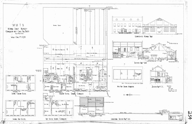
Drawing, Melbourne & Metropolitan Tramways Board (MMTB), "Howard Street Property - conversion into cable car depot", 1925
A4 sheet printed from a pdf file of the "Howard Street Property - conversion into cable car depot". Shows the changes to the buildings in order to provide a running depot for the cable cars that worked the Elizabeth St to Abbotsford line via North Melbourne. Depot required following the closure of the Flemington Road depot when it was converted to electric in July 1925. Drawing not dated. Two current photos of the buildings provided by Mal Rowe - Photos of the front of the buildings - 27/4/2013 and the rear 10/3/2013.trams, tramways, north melbourne, cable trams, conversion, howard st, depot -
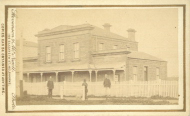 Bacchus Marsh & District Historical Society
Photograph, Court House Main Street Bacchus Marsh 1883
The Court House in Main Street Bacchus Marsh was built in 1858 using local sandstone. It opened in 1859. It has been used for jury trials, a Court of Petty Sessions, a County Court and a Crown Land sales office. Other uses included an office for the Registrar of Births and Deaths, a Diary Inspectors office from 1863-1865, and as meeting rooms for the Bacchus Marsh Roads Board, a forerunner of the Shire Council. It was also used by the Bacchus Marsh Shire Council for its offices until at least 1884. In more recent years it has functioned as a Magistrates Court with weekly court sessions. Small sepia unframed photograph on card with gold border framing photograph. Housed in the album, 'Photographs of Bacchus Marsh and District in 1883 by Stevenson and McNicoll'. The view of the Court House building is seen from the northern side of Main Street looking south or south-east. Three men are standing in of the street in front of the building. The men on the left and the right appear to be police officers. The man in the middle is in civilian clothes and might be an officer or employee of the Court House. A white picket fence is in front of the building. This is no longer present.On the front: Stevenson & McNicoll. Photo. 108 Elizabeth St. Melbourne. COPIES CAN BE OBTAINED AT ANY TIME. On the back: LIGHT & TRUTH inscribed on a banner surmounted by a representation of the rising sun. Copies of this Portrait can be had at any time by sending the Name and Post Office Money Order or Stamps for the amount of order to STEVENSON & McNICOLL LATE BENSON & STEVENSON, Photographers. 108 Elizabeth Street, MELBOURNE. stevenson and mcnicoll 1883 photographs of bacchus marsh and district, courthouses, bacchus marsh court house -
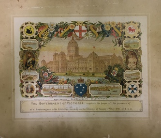 Kew Historical Society Inc
Document - Invitation to the Opening of the Parliament of the Commonwealth, Sands & McDougall Ltd, 1901
The correspondent of the Argus on 10 May 1901 wrote: "The Parliament of the Commonwealth was opened yesterday by the Duke, of Cornwall and York, under a Commission signed by Queen Victoria and subsequently endorsed by King Edward VII. The ceremony was marked by the splendour and solemn impressiveness which befitted its historic importance. An immense assemblage of spectators, drawn mainly, of course, from this state, but in part also from each of the other federated states, and including representatives of other portions of the British Empire and of foreign powers, thronged the spacious, stately, and joyously decorated edifice. The picture was magnificent. It must have printed itself indelibly on the sensitive minds of the thousands of Australians who were privileged to behold it. We may assume that artists will reproduce it in worthy and imperishable forms, and that from generation to generation it will be familiar in the households of the Commonwealth. Our children's children, we may gladly say to-day, will not be ashamed of the function which inaugurated the self-governing rights of the southern British Nation. Nothing was omitted which could add to the grandeur and significance of the occasion. In a broad sense the proceedings were perfectly intelligible to the vast and sympathetic gathering, though the natural limits of a single human voice had to be accepted. The King's son, with his consort and the Governor-General and Lady Hopetoun by his side, and supported by the Governors of the states and other eminent personages, fulfilled his doubly-attested Commission with a simple dignity and a modest manliness altogether admirable. The ceremony was a brilliant spectacle, and, in its sentiment and suggestiveness, an inspiration to a loyal and patriotic people."The document design has artistic and aesthetic merit. While it is not rare, it is representative of the kinds of formal designs used for the Australian Commonwealth celebrations at the time of Federation, and is in excellent condition. Such items as this invitation have local, state and national historic significance as mementoes of a key moment in Australia's history. Locally, the invitation is part of a group of Federation-related items owned by Mrs Grace Tabulo, and displayed at her home - Fairyland - at 57 Malmsbury Street, KewAn invitation, mounted on card to an evening reception at the Exhibition Building, Melbourne, on 9 May 1901, to meet the Duke and Duchess of Cornwall as part of the celebrations of the opening of the first Federal Parliament. A figure of Britannia, in red dress and mailed vest holding a shield like the Union Jack, is on the left of the invitation; she reaches out her hand towards a younger female figure, representing Australia, who is dressed in blue and holds a shield which is white with a blue cross decorated with stars. The writing is on a scroll in the centre of the certificate, and there is a border of vines and vine leaves. The royal crest is at the base of the certificate. Front, printed. gold ink: "His Majesty's Ministers of State for the Commonwealth of Australia request the honour of the presence of / ****l (handwritten) / In the Exhibition Building, Melbourne, on Thursday, 9th May, 1901, to witness / the Opening of the Parliament of the Commonwealth. / Edmund Barton / Prime Minister." Front, bottom left, printed: "The Young Queen / Her hand was still on her sword hilt - the spur was still on her heel ... (and further text) KIPLING'S COMMONWEALTH ODE." Reverse: Mrs G. Tabulo, 57 Malmsbury Streetaustralia -- federation -- 1901, invitations, parliament -- opening -- 1901, grace tabulo -- fairyland -- 57 malmsbury street -- kew (vic.) -
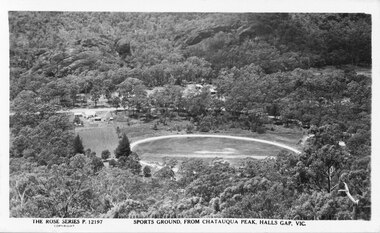 Halls Gap & Grampians Historical Society
Photograph - B/W
This is a postcard of the sports ground in Halls Gap, taken from Chatauqua Peak. It is No. 12197 in the Rose Series of postcards.The photo shows a round clearing (sports ground), seen from above, in the midst of bush. There are some bare strips in the middle of the field and a track around its perimeter. Some buildings are visible to the left of the field and a road runs behind it. There are more buildings just visible through the bush in the centre, on the far side of the road."The Rose Series P. 12197, Sports Ground, from Chatauqua Peak, Halls Gap, Vic" on bottom of postcard.recreation, sport -
Bendigo Historical Society Inc.
Photograph - UNKNOWN MINING PHOTOS - GROUPS OF MINERS
Three black & white photocopies of photos of miners. (a) is a group of 44 miners taken outside a building. They are wearing working clothes and they have a variety of head gear. (b) photo of 53 men and a boy taken in front of a timber structure and heaps of stone. (c) is a photo of a group of 30 miners taken outside a building.photo, unknown mining photos - groups of miners -
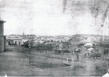 Bendigo Historical Society Inc.
Photograph - MARKET SQUARE 1861, 1861
First town hall - 2 storey building at left. Town Hall Hotel on left. Many single storey building with covered drays and cattle in foreground. Rectangular drain in foreground with gas lamp at corner. Copy of original and very indistinct. James Lerk 28.2.2000 ' Batchelder photo ( copy ) 1861 Market Square'batchelderplace, streetscape, market square -
 Bendigo Historical Society Inc.
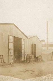
Photograph - ROSELLA PRESERVING FACTORY
Sepia photo, corrugated iron building with 2 double doors. Large building with hip and valley roof. Tall metal ? Tubular chimney at back left. Pallets and containers stacked against wall. On back in ball point pen ' Rosella Factory, Brougham St. In pencil ' new sheds from brick stores'A.W.M Gibbony, ,Pall Mall Bendigoorganization, business, rosella factory -
 Bendigo Historical Society Inc.
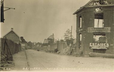
Postcard - ACC LOCK COLLECTION: ESTAIRES AFTER GERMAN OFFENSIVE, POST, 1914-1918
Postcard, WW1, B&W image of Estaires after a German offensive. Damaged/ruined buildings on sides of road. Two signs on building at right - 'Steenwerck Motor Traffic' and 'Estaires'. The latter has two arrows pointing in opposite directions to other towns. Copy Z 24 See also Copy 1401.73postcard, postcard, ww1, france, estaires, ruins -
 Bendigo Historical Society Inc.
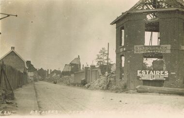
Postcard - ACC LOCK COLLECTION: ESTAIRES AFTER GERMAN OFFENSIVE, POSTCARD, 1914-1918
Postcard, WW1, B&W image of Estaires after a German offensive. Damaged/ruined buildings on sides of road. Two signs on building at right - 'Steenwerck Motor Traffic' and 'Estaires'. The latter has two arrows pointing in opposite directions to other towns. Copy Z 24 See also Copy 1401.108postcard -
 Bendigo Historical Society Inc.
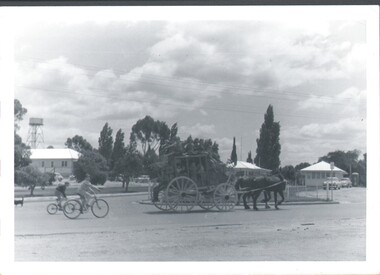
Photograph - HARRY BIGGS COLLECTION: ROYAL MAIL COACH, 1960's
Photograph of a Royal mail Coach drawn by two horses, the coach is full of people with many riding on the top. There are two boys riding bicycles behind the coach, there are several small buildings in the background, a water tank on a tall tower is visible behind the left hand building. The words 'Royal mail' are painted on the side of the coachtopic, objects, transport, royal mail -
 Bendigo Historical Society Inc.
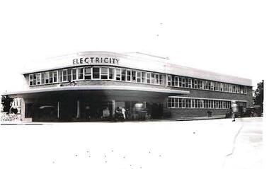
Photograph - S.E.C. VICTORIA, 1941
Black and White Photo, completed S.E.C. Victoria building, Taken March 14 1941, workers putting finishing touches to exterior of the building. person in light coloured clothing crossing the street, two darke coloured vehicles in the background. Rear of photo has 14.3.41 printed in biro and number 53 written in pencil.organization, public utility, electricity company, s.e.c victoria building, sec victoria building -
 Myrtleford and District Historical Society
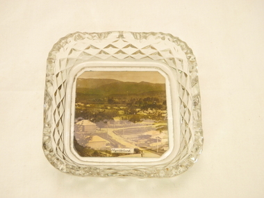
Glass Butter Dish, unknown
Photograph taken in the early 1930's Photographer unknown ? taken for tourism purposes Photograph shows early buildings of Myrtleford.taken from Reform Hill looking towards Mt BuffaloA small, square glass butter mixer. In the base is an early photograph of Myrtleford in the 1930's looking towards Mt Buffalo taken from Reform Hill In the foreground are the homes of early retailers the Robertson's and Glass Families 1870 and 1880 in the middle of the photo is the School Building No 995 and in the distance is an early building of the Butter FactoryPhotograph in base of glass butter mixer is titled 'Myrtleford'glass dish, myrtleford, homes of early retailers, butter factory, state school 995 streetscape -
 Lakes Entrance Regional Historical Society (operating as Lakes Entrance History Centre & Museum)
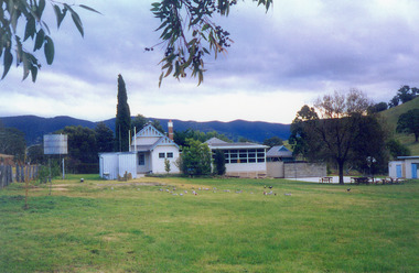
Photograph, 1993
Taken July 1993.Colour photograph of the Ensay Primary School number 2953, East Gippsland. Taken from rear school ground, it shows original timber building with gable roof, brick chimney with chimney pot, portable classroom, playground and out buildings. Large corrugated iron tank on stand at side fence. Ensay Victoriaschools -
 Bendigo Historical Society Inc.
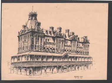
Artwork,other - SHAMROCK HOTEL BY JAN NEIL 1972
Black ink sketch on buff coloured card, titled Shamrock Hotel. Written on the front is Shamrock Hotel Jan Neil 1972. It is a detailed drawing of the Hotel, with no other buildings in it. It is an ornate building of four stories. Written in pencil on the back is: Received 12.9.2002 GB. Derek? Augwin 2/29 Glebe Ave Cheltenham.artwork, shamrock hotel, jan neil -
 Stawell Historical Society Inc
Photograph, North Cross Reef Mine & Mining Scene 1870 -- B/W Photo & Coloured Painting
Mining Scene - North Cross Reef Co.B/W North Cross Reef with buildings, poppet heads, Tailings and wood stack with people. Two colour prints of North cross Reef. One at a different angle to B/W. Second taken further back with wood stacks, tailing dam fenced in beyond poppet heads buildings chimmney's smoking. stawell